2018 Indicators: SST's / MSLP / Sal / Steering / Shear / Instability (Graphic updates at first post)

This is the general tropical discussion area. Anyone can take their shot at predicting a storms path.

Moderator: S2k Moderators

Forum rules

The posts in this forum are NOT official forecasts and should not be used as such. They are just the opinion of the poster and may or may not be backed by sound meteorological data. They are NOT endorsed by any professional institution or STORM2K. For official information, please refer to products from the National Hurricane Center and National Weather Service.

Help Support Storm2K
Message
Author
Ntxw
Storm2k Moderator
Storm2k Moderator
Posts: 21501
Joined: Wed Oct 21, 2009 6:34 pm
Location: DFW, Texas

Re: 2018 Indicators: SST's / MSLP / Sal / Steering / Shear / Instability (Graphic updates at first post)

#921 Postby Ntxw » Sat Aug 25, 2018 9:04 am

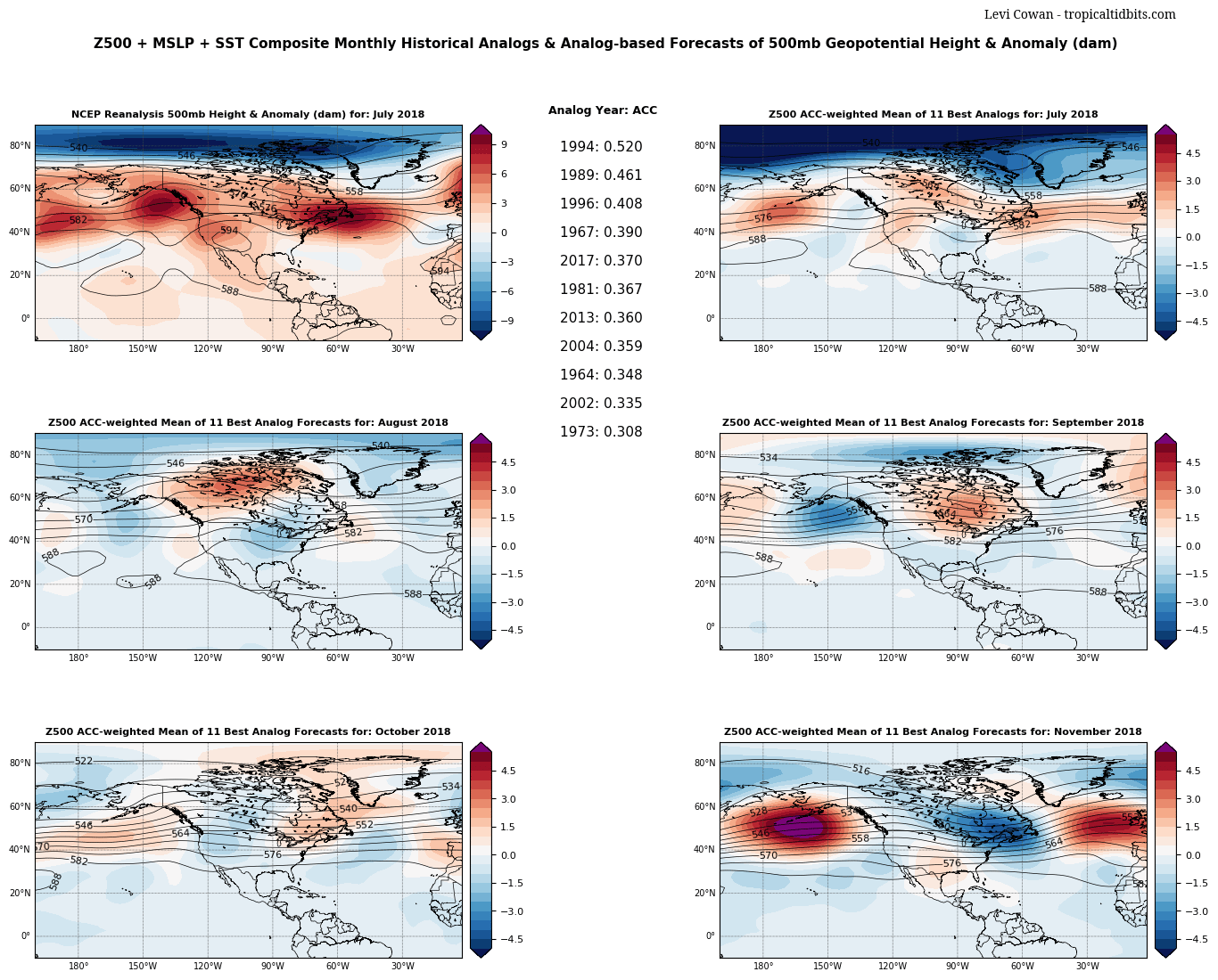
1900hurricane wrote:1994 is a good Eastern Pacific match too. That season features multiple storms tracking west through the Central Pacific, similar to how this year has behaved thus far.

http://upload.wikimedia.org/wikipedia/c ... ry_map.png


The 1994 El Nino did not take off until late September/early October. Took a long time to get going. Also not scientific but the list of names this year for the EPAC/ATL is the same list as 1994.
1 likes   
The above post and any post by Ntxw is NOT an official forecast and should not be used as such. It is just the opinion of the poster and may or may not be backed by sound meteorological data. It is NOT endorsed by any professional institution including Storm2k. For official information, please refer to NWS products.

  Help support Storm2K!
Help Support Storm2K

stormlover2013
Category 5
Category 5
Posts: 2312
Joined: Thu Aug 22, 2013 12:06 pm
Location: Lumberton, Texas

Re: 2018 Indicators: SST's / MSLP / Sal / Steering / Shear / Instability (Graphic updates at first post)

#922 Postby stormlover2013 » Sat Aug 25, 2018 9:16 am

2002 is the best match for this year
0 likes   

Ntxw
Storm2k Moderator
Storm2k Moderator
Posts: 21501
Joined: Wed Oct 21, 2009 6:34 pm
Location: DFW, Texas

Re: 2018 Indicators: SST's / MSLP / Sal / Steering / Shear / Instability (Graphic updates at first post)

#923 Postby Ntxw » Sat Aug 25, 2018 9:23 am

stormlover2013 wrote:2002 is the best match for this year


Global SSTa, NAO, Pacific basin activity, and 500mb analogs matches up with 1994 the closest. 2002 is anecdotal but the numbers don't line up quite as close.

Image
0 likes   
The above post and any post by Ntxw is NOT an official forecast and should not be used as such. It is just the opinion of the poster and may or may not be backed by sound meteorological data. It is NOT endorsed by any professional institution including Storm2k. For official information, please refer to NWS products.


  Help support Storm2K!

Help Support Storm2K


User avatar
cycloneye
Admin
Admin
Posts: 139060
Age: 67
Joined: Thu Oct 10, 2002 10:54 am
Location: San Juan, Puerto Rico

Re: 2018 Indicators: SST's / MSLP / Sal / Steering / Shear / Instability (Graphic updates at first post)

#924 Postby cycloneye » Sat Aug 25, 2018 9:28 am

A reminder of how the 1994 analog season fared.

Image
0 likes   
Visit the Caribbean-Central America Weather Thread where you can find at first post web cams,radars
and observations from Caribbean basin members Click Here

stormlover2013
Category 5
Category 5
Posts: 2312
Joined: Thu Aug 22, 2013 12:06 pm
Location: Lumberton, Texas

Re: 2018 Indicators: SST's / MSLP / Sal / Steering / Shear / Instability (Graphic updates at first post)

#925 Postby stormlover2013 » Sat Aug 25, 2018 9:30 am

Big joe: In addition pattern very much like analog year of 2002, that produced Lili and Isidore, Extensive discussion on weatherbell.com premium on how the US got off lucky and same kind of pattern warrants concern Could have been 2 major gulf hits in 10 days 2002
2002 a major analog year in our forecasts from spring, 1 of 4
Keep in mind that year also set a record the other way.. 2 cat 4s in the gulf within 10 days
0 likes   

User avatar
TheStormExpert
Category 5
Category 5
Posts: 8487
Age: 30
Joined: Wed Feb 16, 2011 5:38 pm
Location: Palm Beach Gardens, FL

Re: 2018 Indicators: SST's / MSLP / Sal / Steering / Shear / Instability (Graphic updates at first post)

#926 Postby TheStormExpert » Sat Aug 25, 2018 9:38 am

Ntxw wrote:
stormlover2013 wrote:2002 is the best match for this year


Global SSTa, NAO, Pacific basin activity, and 500mb analogs matches up with 1994 the closest. 2002 is anecdotal but the numbers don't line up quite as close.

Image

Why is 2017 even considered an analog for this year?
0 likes   
The following post is NOT an official forecast and should not be used as such. It is just the opinion of the poster and may or may not be backed by sound meteorological data. It is NOT endorsed by storm2k.org.

Ntxw
Storm2k Moderator
Storm2k Moderator
Posts: 21501
Joined: Wed Oct 21, 2009 6:34 pm
Location: DFW, Texas

Re: 2018 Indicators: SST's / MSLP / Sal / Steering / Shear / Instability (Graphic updates at first post)

#927 Postby Ntxw » Sat Aug 25, 2018 9:41 am

TheStormExpert wrote:
Ntxw wrote:
stormlover2013 wrote:2002 is the best match for this year


Global SSTa, NAO, Pacific basin activity, and 500mb analogs matches up with 1994 the closest. 2002 is anecdotal but the numbers don't line up quite as close.

https://images2.imgbox.com/2e/31/EThTdkGJ_o.png

Why is 2017 even considered an analog for this year?


Because it looks at the broader picture not just for a hurricane season for instance. All things considered globally. SSTa's in the Atlantic are not a good match to 2017 but higher latitudes 500mb pattern are not dissimilar. With a warming globe sometimes you will often see back to back years showing similarities despite quite opposite events such as Enso due to expanding hadley cells and SST increases. Even with a colder anomaly, that anomaly today is much warmer than actual SSTs back in 1994.

Analogs are not going to give you an exact path, only a stepping stone.
3 likes   
The above post and any post by Ntxw is NOT an official forecast and should not be used as such. It is just the opinion of the poster and may or may not be backed by sound meteorological data. It is NOT endorsed by any professional institution including Storm2k. For official information, please refer to NWS products.


  Help support Storm2K!

Help Support Storm2K


User avatar
CyclonicFury
Category 5
Category 5
Posts: 1975
Age: 25
Joined: Sun Jul 02, 2017 12:32 pm
Location: NC
Contact:

Re: 2018 Indicators: SST's / MSLP / Sal / Steering / Shear / Instability (Graphic updates at first post)

#928 Postby CyclonicFury » Sat Aug 25, 2018 10:03 am

Based on CDAS data, the Atlantic MDR is now warmer than normal for the first time since mid-March. Much of the region is now warm enough to support tropical cyclone development.
5 likes   
NCSU B.S. in Meteorology Class of 2021. Tropical weather blogger at http://www.cyclonicfury.com. My forecasts and thoughts are NOT official, for official forecasts please consult the National Hurricane Center.

User avatar
blp
Category 5
Category 5
Posts: 2805
Age: 45
Joined: Thu Sep 09, 2004 7:51 pm
Location: Miami, FL
Contact:

Re: 2018 Indicators: SST's / MSLP / Sal / Steering / Shear / Instability (Graphic updates at first post)

#929 Postby blp » Sat Aug 25, 2018 12:24 pm

1 likes   
The following post is NOT an official forecast and should not be used as such. It is just the opinion of the poster and may or may not be backed by sound meteorological data. It is NOT endorsed by any professional institution including storm2k.org For Official Information please refer to the NHC and NWS products.

User avatar
Hammy
Category 5
Category 5
Posts: 5594
Age: 40
Joined: Fri May 25, 2012 5:25 pm
Contact:

Re: 2018 Indicators: SST's / MSLP / Sal / Steering / Shear / Instability (Graphic updates at first post)

#930 Postby Hammy » Sat Aug 25, 2018 12:36 pm


Does this mean more west-based activity or simply the season coming in well below forecasts?
0 likes   
The above post is not official and should not be used as such. It is the opinion of the poster and may or may not be backed by sound meteorological data. It is not endorsed by any professional institution or storm2k.org. For official information, please refer to the NHC and NWS products.

User avatar
gatorcane
S2K Supporter
S2K Supporter
Posts: 23499
Age: 46
Joined: Sun Mar 13, 2005 3:54 pm
Location: Boca Raton, FL

Re: 2018 Indicators: SST's / MSLP / Sal / Steering / Shear / Instability (Graphic updates at first post)

#931 Postby gatorcane » Sat Aug 25, 2018 12:47 pm

Looks warmer across the MDR between Lesser Antilles and Africa indeed:

Image
1 likes   

User avatar
NDG
S2K Supporter
S2K Supporter
Posts: 14933
Joined: Sun Jul 09, 2006 10:14 pm
Location: Orlando, FL

Re: 2018 Indicators: SST's / MSLP / Sal / Steering / Shear / Instability (Graphic updates at first post)

#932 Postby NDG » Sat Aug 25, 2018 1:05 pm

SSTs from the NW Caribbean to the GOM to around the Bahamas are >30C, it will be interesting as the TWs start tracking over these very warm waters starting over the next few days.

Image
0 likes   

User avatar
SoupBone
Category 5
Category 5
Posts: 3073
Joined: Tue Sep 20, 2005 5:24 pm

Re: 2018 Indicators: SST's / MSLP / Sal / Steering / Shear / Instability (Graphic updates at first post)

#933 Postby SoupBone » Sat Aug 25, 2018 1:21 pm

Hammy wrote:


Does this mean more west-based activity or simply the season coming in well below forecasts?


I read this as troughs starting to come down in September/October, favoring eastern U.S. solutions. Honestly though, I always have a tough time reading and understanding Meteorology jargon (acronyms).

"Luckily, continued W-CP quasi-stationary forcing like we have now favors a complete 180 in the E US pattern by late Sept/Oct w/ big troughs over E US/Atlantic Canada."
0 likes   
Personal Forecast Disclaimer:
The posts in this forum are NOT official forecast and should not be used as such. They are just the opinion of the poster and may or may not be backed by sound meteorological data. They are NOT endorsed by any professional institution or storm2k.org. For official information, please refer to the NHC and NWS products.

AutoPenalti
Category 5
Category 5
Posts: 3949
Age: 27
Joined: Mon Aug 17, 2015 4:16 pm
Location: Ft. Lauderdale, Florida

Re: 2018 Indicators: SST's / MSLP / Sal / Steering / Shear / Instability (Graphic updates at first post)

#934 Postby AutoPenalti » Sat Aug 25, 2018 1:25 pm

Hammy wrote:


Does this mean more west-based activity or simply the season coming in well below forecasts?

TC’s will have a hard time developing in the MDR because of the sinking air and the mid levels being so dry.
1 likes   
The posts in this forum are NOT official forecasts and should not be used as such. They are just the opinion of the poster and may or may not be backed by sound meteorological data. They are NOT endorsed by any professional institution or STORM2K. For official information, please refer to products from the NHC and NWS.


Model Runs Cheat Sheet:
GFS (5:30 AM/PM, 11:30 AM/PM)
HWRF, GFDL, UKMET, NAVGEM (6:30-8:00 AM/PM, 12:30-2:00 AM/PM)
ECMWF (1:45 AM/PM)

TCVN
is a weighted averaged

Ntxw
Storm2k Moderator
Storm2k Moderator
Posts: 21501
Joined: Wed Oct 21, 2009 6:34 pm
Location: DFW, Texas

Re: 2018 Indicators: SST's / MSLP / Sal / Steering / Shear / Instability (Graphic updates at first post)

#935 Postby Ntxw » Sat Aug 25, 2018 1:30 pm


I think his tweet is implying that the expanded hadley cell will continue the dominance of dry air over the MDR at longer timescales. Weaker gradient of SSTs between the subtropical and TA (tropical atlantic). That's my interpretation of that tweet.
3 likes   
The above post and any post by Ntxw is NOT an official forecast and should not be used as such. It is just the opinion of the poster and may or may not be backed by sound meteorological data. It is NOT endorsed by any professional institution including Storm2k. For official information, please refer to NWS products.


  Help support Storm2K!

Help Support Storm2K


User avatar
MetroMike
Category 3
Category 3
Posts: 826
Joined: Sun Aug 29, 2004 8:13 pm
Location: Tampa Bay
Contact:

Re: 2018 Indicators: SST's / MSLP / Sal / Steering / Shear / Instability (Graphic updates at first post)

#936 Postby MetroMike » Sat Aug 25, 2018 2:53 pm

Ntxw wrote:


I think his tweet is implying that the expanded hadley cell will continue the dominance of dry air over the MDR at longer timescales. Weaker gradient of SSTs between the subtropical and TA (tropical atlantic). That's my interpretation of that tweet.


Yes we are deciphering that. The word "locus" means a center or gathering area, and the word "ascent" of course means upward motion. In this case the SST's have little to say about favorable conditions in the TA.
0 likes   

User avatar
Steve
S2K Supporter
S2K Supporter
Posts: 8606
Joined: Sat Apr 05, 2003 11:41 pm
Location: Not a state-caster

Re: 2018 Indicators: SST's / MSLP / Sal / Steering / Shear / Instability (Graphic updates at first post)

#937 Postby Steve » Sat Aug 25, 2018 3:25 pm

Counter is the JMA model which was on weather bell’s Saturday summary showing a reversal of rising/sinking air patterns favoring much more upward motion in the Atlantic coming after a week to ten days. Bastardi thinks a pulse with up to 4 systems could be between September 1-15 (Ithink were his dates) obviously with ridging entrenched across the western Atlantic. Who knows after that, but I’d still bet on some October homespun action before whenever the season shuts down.

Stay tuned for the tropics revving up shortly is the message.
0 likes   

tolakram
Admin
Admin
Posts: 19165
Age: 60
Joined: Sun Aug 27, 2006 8:23 pm
Location: Florence, KY (name is Mark)

Re: 2018 Indicators: SST's / MSLP / Sal / Steering / Shear / Instability (Graphic updates at first post)

#938 Postby tolakram » Sat Aug 25, 2018 7:26 pm

Instability over the tropical Atlantic has improved somewhat.

Image
0 likes   
M a r k
- - - - -
Join us in chat: Storm2K Chatroom Invite. Android and IOS apps also available.

The posts in this forum are NOT official forecasts and should not be used as such. Posts are NOT endorsed by any professional institution or STORM2K.org. For official information and forecasts, please refer to NHC and NWS products.

User avatar
Kingarabian
S2K Supporter
S2K Supporter
Posts: 15434
Joined: Sat Aug 08, 2009 3:06 am
Location: Honolulu, Hawaii

Re: 2018 Indicators: SST's / MSLP / Sal / Steering / Shear / Instability (Graphic updates at first post)

#939 Postby Kingarabian » Sat Aug 25, 2018 7:34 pm

12z Euro shows the Atlantic MDR opening up for business in the first week of September with much more favorable VP200 anomalies.
0 likes   
RIP Kobe Bryant

User avatar
gatorcane
S2K Supporter
S2K Supporter
Posts: 23499
Age: 46
Joined: Sun Mar 13, 2005 3:54 pm
Location: Boca Raton, FL

Re: 2018 Indicators: SST's / MSLP / Sal / Steering / Shear / Instability (Graphic updates at first post)

#940 Postby gatorcane » Sat Aug 25, 2018 9:39 pm

Another monster wave about to make the splash. Sooner or later you got to assume one of these waves will end up developing:

Image
1 likes   


Return to “Talkin' Tropics”

Who is online

Users browsing this forum: No registered users and 197 guests