2018 Indicators: SST's / MSLP / Sal / Steering / Shear / Instability (Graphic updates at first post)
Moderator: S2k Moderators
Forum rules

The posts in this forum are NOT official forecasts and should not be used as such. They are just the opinion of the poster and may or may not be backed by sound meteorological data. They are NOT endorsed by any professional institution or STORM2K. For official information, please refer to products from the National Hurricane Center and National Weather Service.

Re: 2018 Indicators: SST's / MSLP / Sal / Steering / Shear / Instability (Graphic updates at first post)
I still think 2002 is a good analog year which also had a cool MDR and a developing central based weak El Nino even warmer that this year so far, that year the end of August & September was fairly busy with 9 named systems which 2 became major hurricanes.
0 likes
Re: 2018 Indicators: SST's / MSLP / Sal / Steering / Shear / Instability (Graphic updates at first post)
The MDR has warmed up some over the past few days, the 26 C isotherm now reaches at least the 15th latitude east of the 40th longitude instead of being closer to the 10th latitude during last month.

1 likes

Re: 2018 Indicators: SST's / MSLP / Sal / Steering / Shear / Instability (Graphic updates at first post)
NDG wrote:The MDR has warmed up some over the past few days, the 26 C isotherm now reaches at least the 15th latitude east of the 40th longitude instead of being closer to the 10th latitude during last month.

yep average MDR temps are near zero on the CDAS
0 likes
FSU '24 student pursuing a degree in meteorology. Consult NHC for official information.


Re: 2018 Indicators: SST's / MSLP / Sal / Steering / Shear / Instability (Graphic updates at first post)
I am not liking the setup that has been present so far in July and early August. With the strong High over Newfoundland and low pressure over the Midwest. Its a dangerous combination for landfalls if you have any waves that make it past 40w at a lower latitude.

1 likes
The following post is NOT an official forecast and should not be used as such. It is just the opinion of the poster and may or may not be backed by sound meteorological data. It is NOT endorsed by any professional institution including storm2k.org For Official Information please refer to the NHC and NWS products.
-
Kingarabian

- S2K Supporter

- Posts: 15433
- Joined: Sat Aug 08, 2009 3:06 am
- Location: Honolulu, Hawaii
Re: 2018 Indicators: SST's / MSLP / Sal / Steering / Shear / Instability (Graphic updates at first post)
Just like the EPAC, the Atlantic still needs better atmospheric conditions for there to be decent storms.
1 likes
RIP Kobe Bryant
-
gatorcane

- S2K Supporter
- Posts: 23499
- Age: 46
- Joined: Sun Mar 13, 2005 3:54 pm
- Location: Boca Raton, FL
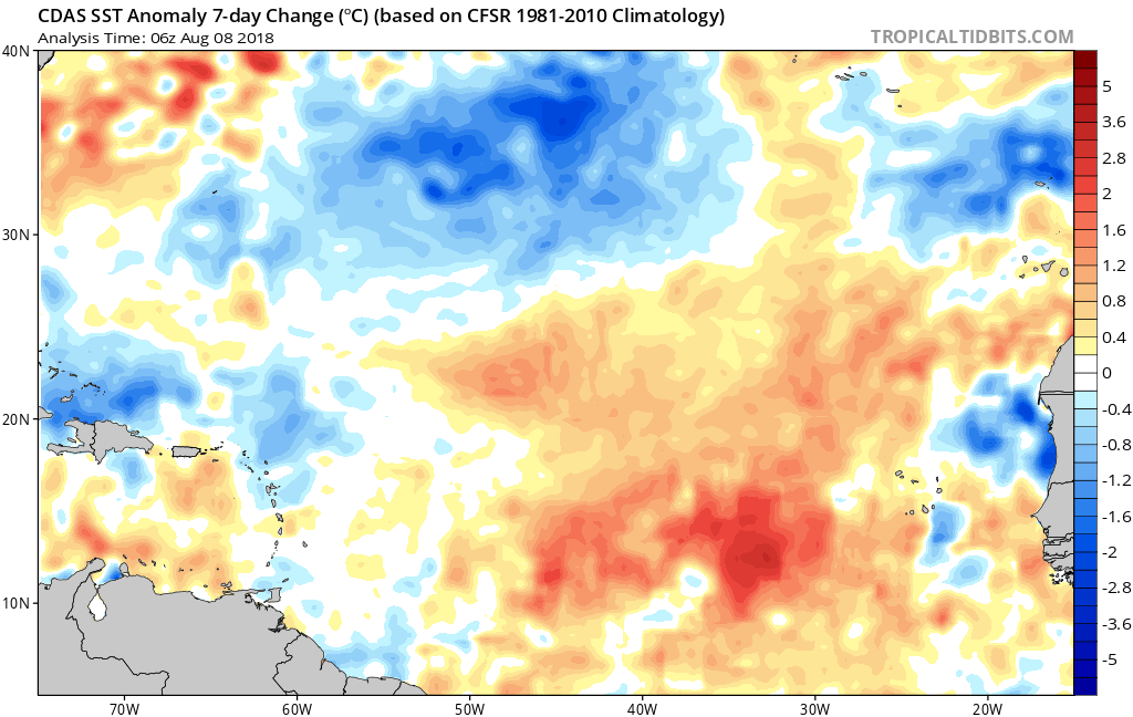
Re: 2018 Indicators: SST's / MSLP / Sal / Steering / Shear / Instability (Graphic updates at first post)
Graphic below shows the extent of warming in the Eastern MDR this past week:
1 likes
-
Hurricaneman

- Category 5

- Posts: 7280
- Age: 43
- Joined: Tue Aug 31, 2004 3:24 pm
- Location: central florida
Re: 2018 Indicators: SST's / MSLP / Sal / Steering / Shear / Instability (Graphic updates at first post)
I’m thinking something big could happen and no model is picking up on it yet, similar to what happened with Beryl or a real extreme example of Joaquin in 2015 as with that system models didn’t pick up on it until it was formed and strengthening so hopefully this isn’t another case of models under developing stuff in the Atlantic and it’s correct and nothing really develops until September
0 likes

Re: 2018 Indicators: SST's / MSLP / Sal / Steering / Shear / Instability (Graphic updates at first post)
Hurricaneman wrote:I’m thinking something big could happen and no model is picking up on it yet, similar to what happened with Beryl or a real extreme example of Joaquin in 2015 as with that system models didn’t pick up on it until it was formed and strengthening so hopefully this isn’t another case of models under developing stuff in the Atlantic and it’s correct and nothing really develops until September
If I recall correctly, this was happening last year as well--many of the models were failing to show anything beyond about 4-5 days out from when they'd form.
0 likes
The above post is not official and should not be used as such. It is the opinion of the poster and may or may not be backed by sound meteorological data. It is not endorsed by any professional institution or storm2k.org. For official information, please refer to the NHC and NWS products.
-
TheStormExpert

- Category 5
- Posts: 8487
- Age: 30
- Joined: Wed Feb 16, 2011 5:38 pm
- Location: Palm Beach Gardens, FL
Re: 2018 Indicators: SST's / MSLP / Sal / Steering / Shear / Instability (Graphic updates at first post)
gatorcane wrote:Graphic below shows the extent of warming in the Eastern MDR this past week:
https://s8.postimg.cc/sn3bpgjhx/cdas-sf ... eatl_1.png
Same thing happened this time last month for it to significantly cool down by months end.
0 likes
The following post is NOT an official forecast and should not be used as such. It is just the opinion of the poster and may or may not be backed by sound meteorological data. It is NOT endorsed by storm2k.org.
-
TheStormExpert
- Category 5
- Posts: 8487
- Age: 30
- Joined: Wed Feb 16, 2011 5:38 pm
- Location: Palm Beach Gardens, FL
Re: 2018 Indicators: SST's / MSLP / Sal / Steering / Shear / Instability (Graphic updates at first post)
Hammy wrote:Hurricaneman wrote:I’m thinking something big could happen and no model is picking up on it yet, similar to what happened with Beryl or a real extreme example of Joaquin in 2015 as with that system models didn’t pick up on it until it was formed and strengthening so hopefully this isn’t another case of models under developing stuff in the Atlantic and it’s correct and nothing really develops until September
If I recall correctly, this was happening last year as well--many of the models were failing to show anything beyond about 4-5 days out from when they'd form.
Yes this is very true, most (if not all) models did not predict the redevelopment of Harvey in the western Gulf of Mexico, heck even several days prior to landfall it was only forecasted to strike as a minimal Cat.1.
1 likes
The following post is NOT an official forecast and should not be used as such. It is just the opinion of the poster and may or may not be backed by sound meteorological data. It is NOT endorsed by storm2k.org.
-
Kingarabian
- S2K Supporter
- Posts: 15433
- Joined: Sat Aug 08, 2009 3:06 am
- Location: Honolulu, Hawaii
Re: 2018 Indicators: SST's / MSLP / Sal / Steering / Shear / Instability (Graphic updates at first post)
TheStormExpert wrote:Hammy wrote:Hurricaneman wrote:I’m thinking something big could happen and no model is picking up on it yet, similar to what happened with Beryl or a real extreme example of Joaquin in 2015 as with that system models didn’t pick up on it until it was formed and strengthening so hopefully this isn’t another case of models under developing stuff in the Atlantic and it’s correct and nothing really develops until September
If I recall correctly, this was happening last year as well--many of the models were failing to show anything beyond about 4-5 days out from when they'd form.
Yes this is very true, most (if not all) models did not predict the redevelopment of Harvey in the western Gulf of Mexico, heck even several days prior to landfall it was only forecasted to strike as a minimal Cat.1.
I remember it clear as day. Euro just showed it out of nowhere, a less than 72 hour window.
0 likes
RIP Kobe Bryant
-
Hurricaneman
- Category 5
- Posts: 7280
- Age: 43
- Joined: Tue Aug 31, 2004 3:24 pm
- Location: central florida
Re: 2018 Indicators: SST's / MSLP / Sal / Steering / Shear / Instability (Graphic updates at first post)
Kingarabian wrote:TheStormExpert wrote:Hammy wrote:
If I recall correctly, this was happening last year as well--many of the models were failing to show anything beyond about 4-5 days out from when they'd form.
Yes this is very true, most (if not all) models did not predict the redevelopment of Harvey in the western Gulf of Mexico, heck even several days prior to landfall it was only forecasted to strike as a minimal Cat.1.
I remember it clear as day. Euro just showed it out of nowhere, a less than 72 hour window.
If I remember everyone scoffed at the Euro with Harvey and were eating crow in the end
2 likes
-
tolakram
- Admin

- Posts: 19165
- Age: 60
- Joined: Sun Aug 27, 2006 8:23 pm
- Location: Florence, KY (name is Mark)
Re: 2018 Indicators: SST's / MSLP / Sal / Steering / Shear / Instability (Graphic updates at first post)
Same thing every year and usually the same posters. Who am I looking at?
S2K thrives on robust, polite, and honest scientific discussions, not whiny schoolyard style posts about how the season or conditions suck or a storm sucks or is somehow not worthy.
Please consider this before making a post here or anywhere else on the forums. Thanks.
S2K thrives on robust, polite, and honest scientific discussions, not whiny schoolyard style posts about how the season or conditions suck or a storm sucks or is somehow not worthy.
Please consider this before making a post here or anywhere else on the forums. Thanks.
15 likes
M a r k
- - - - -
Join us in chat: Storm2K Chatroom Invite. Android and IOS apps also available.
The posts in this forum are NOT official forecasts and should not be used as such. Posts are NOT endorsed by any professional institution or STORM2K.org. For official information and forecasts, please refer to NHC and NWS products.
-
Socalhurcnegirl227
- Category 1

- Posts: 267
- Age: 35
- Joined: Mon Jun 06, 2016 6:39 pm
- Location: Santa Barbara, CA
Re: 2018 Indicators: SST's / MSLP / Sal / Steering / Shear / Instability (Graphic updates at first post)
TheStormExpert wrote:Hammy wrote:Hurricaneman wrote:I’m thinking something big could happen and no model is picking up on it yet, similar to what happened with Beryl or a real extreme example of Joaquin in 2015 as with that system models didn’t pick up on it until it was formed and strengthening so hopefully this isn’t another case of models under developing stuff in the Atlantic and it’s correct and nothing really develops until September
If I recall correctly, this was happening last year as well--many of the models were failing to show anything beyond about 4-5 days out from when they'd form.
Yes this is very true, most (if not all) models did not predict the redevelopment of Harvey in the western Gulf of Mexico, heck even several days prior to landfall it was only forecasted to strike as a minimal Cat.1.
ya i remember this as well, i remember at one point it was only forecasted to be a tropical storm hitting brownsville
0 likes
"I'm a wandress, i'm a one night stand,
dont belong to no city, dont belong to no man
i'm the violence in the pouring rain,
I'm a hurricane"
dont belong to no city, dont belong to no man
i'm the violence in the pouring rain,
I'm a hurricane"
-
CyclonicFury

- Category 5
- Posts: 1971
- Age: 25
- Joined: Sun Jul 02, 2017 12:32 pm
- Location: NC
- Contact:
Re: 2018 Indicators: SST's / MSLP / Sal / Steering / Shear / Instability (Graphic updates at first post)
It wouldn't be too difficult to get a near average season in terms of named storms since we have already had four. ACE will probably be below normal though, since it looks like August won't produce too much. El Niño is developing very slowly and the MDR has warmed a lot recently, so I do think we could see a burst of activity beginning in the last week of August into September.
3 likes
NCSU B.S. in Meteorology Class of 2021. Tropical weather blogger at http://www.cyclonicfury.com. My forecasts and thoughts are NOT official, for official forecasts please consult the National Hurricane Center.

Re: 2018 Indicators: SST's / MSLP / Sal / Steering / Shear / Instability (Graphic updates at first post)
Hurricaneman wrote:Kingarabian wrote:TheStormExpert wrote:Yes this is very true, most (if not all) models did not predict the redevelopment of Harvey in the western Gulf of Mexico, heck even several days prior to landfall it was only forecasted to strike as a minimal Cat.1.
I remember it clear as day. Euro just showed it out of nowhere, a less than 72 hour window.
If I remember everyone scoffed at the Euro with Harvey and were eating crow in the end
Canadian had it continuing across the Yucatan and staying developed. The EC and GFS had it stretched it out and barely closed after it was to exit the peninsula. Euro caught up, but it didn't initially show anything like what the NAM was showing strength wise. I guess we can always fit in a run here or there, but I wasn't impressed with either the Euro or American's mid-range forecast with Harvey. They were unsatisfactory IMHO.
2 likes
Re: 2018 Indicators: SST's / MSLP / Sal / Steering / Shear / Instability (Graphic updates at first post)
This year's been compared to 2002 a lot and I found an interesting satellite image from August 18 that bears a striking comparison to the current satellite appearance, albeit with much deeper convection--most of the tropical convection in the 2002 image being closer to -50C. This was 11 days before anything formed.

2 likes
The above post is not official and should not be used as such. It is the opinion of the poster and may or may not be backed by sound meteorological data. It is not endorsed by any professional institution or storm2k.org. For official information, please refer to the NHC and NWS products.
Re: 2018 Indicators: SST's / MSLP / Sal / Steering / Shear / Instability (Graphic updates at first post)

0 likes
FSU '24 student pursuing a degree in meteorology. Consult NHC for official information.
Re: 2018 Indicators: SST's / MSLP / Sal / Steering / Shear / Instability (Graphic updates at first post)
Here on August 10 we've climbed the first quarter of the climo ramp (a steep upward slope in activity that starts at the beginning of August and runs up until Sept 10). I like to think of the Atlantic hurricane season ramp up as analogous to the process of going broke...slowly at first then all at once. Stuff just tends to start happening/escalating out of nowhere late in the month and into Sept. On a weather forum some degree of impatience goes with the territory but maintaining a historical perspective sure goes a long way. 8-20 is a mere week and a half away.
7 likes
Who is online
Users browsing this forum: cycloneye, Hurricane2022, hurricanes1234, NotSparta, pepecool20, revjohn, zzzh and 153 guests