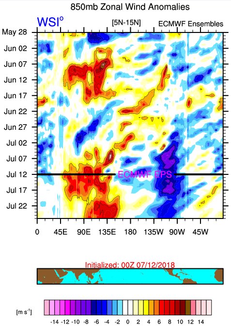
2018 Indicators: SST's / MSLP / Sal / Steering / Shear / Instability (Graphic updates at first post)

This is the general tropical discussion area. Anyone can take their shot at predicting a storms path.

Moderator: S2k Moderators

Forum rules

The posts in this forum are NOT official forecasts and should not be used as such. They are just the opinion of the poster and may or may not be backed by sound meteorological data. They are NOT endorsed by any professional institution or STORM2K. For official information, please refer to products from the National Hurricane Center and National Weather Service.

Help Support Storm2K
Message
Author
User avatar
CyclonicFury
Category 5
Category 5
Posts: 1971
Age: 25
Joined: Sun Jul 02, 2017 12:32 pm
Location: NC
Contact:

Re: 2018 Indicators: SST's / MSLP / Sal / Steering / Shear / Instability (Graphic updates at first post)

#541 Postby CyclonicFury » Wed Jul 11, 2018 2:53 pm

Kingarabian wrote:
NotSparta wrote:
WeatherEmperor wrote:It looks like the PMM had collapsed somewhat. Are there any indications/forecasts that show the PMM going stronger/more positive again??


Sent from my iPhone using Tapatalk


Climate models like to, but the GFS & CFS keep EP trades much stronger than avg, meaning a possibility for a -PMM pattern, imo


Waters W/SW of Baja California have drastically rewarmed this past week:

Image

Also noticeably warmer so far compared to last month at this time:

Image

That's only a tiny portion of the Pacific. Overall, the PMM has significantly weakened since May. This typically happens during the summer, but not quite to this extent.
5 likes   
NCSU B.S. in Meteorology Class of 2021. Tropical weather blogger at http://www.cyclonicfury.com. My forecasts and thoughts are NOT official, for official forecasts please consult the National Hurricane Center.

User avatar
Kingarabian
S2K Supporter
S2K Supporter
Posts: 15433
Joined: Sat Aug 08, 2009 3:06 am
Location: Honolulu, Hawaii

Re: 2018 Indicators: SST's / MSLP / Sal / Steering / Shear / Instability (Graphic updates at first post)

#542 Postby Kingarabian » Wed Jul 11, 2018 2:57 pm

CyclonicFury wrote:
Kingarabian wrote:
NotSparta wrote:
Climate models like to, but the GFS & CFS keep EP trades much stronger than avg, meaning a possibility for a -PMM pattern, imo


Waters W/SW of Baja California have drastically rewarmed this past week:

[img]https://i.imgur.com/Ry3361s.png[img]

Also noticeably warmer so far compared to last month at this time:

[img]https://i.imgur.com/eWXjDPa.gif[img]

That's only a tiny portion of the Pacific. Overall, the PMM has significantly weakened since May. This typically happens during the summer, but not quite to this extent.


The PMM is not the SST's of the entire CPAC and EPAC. Per its definition, its SST config is also very dependent on the waters off Baja California. So the warming we're seeing is not really a tiny portion.

Image
1 likes   
RIP Kobe Bryant

User avatar
NotSparta
Professional-Met
Professional-Met
Posts: 1645
Age: 22
Joined: Fri Aug 18, 2017 8:24 am
Location: Naples, FL
Contact:

Re: 2018 Indicators: SST's / MSLP / Sal / Steering / Shear / Instability (Graphic updates at first post)

#543 Postby NotSparta » Wed Jul 11, 2018 3:59 pm

imo, there's a potential +AMM bkg state setting up

 https://twitter.com/NotSparta_wx/status/1017148562579312640


3 likes   
This post was probably an opinion of mine, and in no way is official. Please refer to http://www.hurricanes.gov for official tropical analysis and advisories.

My website, with lots of tropical wx graphics, including satellite and recon: http://cyclonicwx.com

User avatar
cycloneye
Admin
Admin
Posts: 139028
Age: 67
Joined: Thu Oct 10, 2002 10:54 am
Location: San Juan, Puerto Rico

Re: 2018 Indicators: SST's / MSLP / Sal / Steering / Shear / Instability (Graphic updates at first post)

#544 Postby cycloneye » Thu Jul 12, 2018 5:44 am

@BenNollWeather
Conditions across the deep tropical Atlantic will be unfavorable for organized development over the next several weeks as atmospheric patterns lean in the direction of El Niño.

Don't sleep on the sub-tropical Atlantic, however.


 https://twitter.com/BenNollWeather/status/1017358030139113472


1 likes   
Visit the Caribbean-Central America Weather Thread where you can find at first post web cams,radars
and observations from Caribbean basin members Click Here

AutoPenalti
Category 5
Category 5
Posts: 3949
Age: 27
Joined: Mon Aug 17, 2015 4:16 pm
Location: Ft. Lauderdale, Florida

Re: 2018 Indicators: SST's / MSLP / Sal / Steering / Shear / Instability (Graphic updates at first post)

#545 Postby AutoPenalti » Thu Jul 12, 2018 9:31 am

Season doesn’t really ramp up till August-September, but worth keeping a look out.
0 likes   
The posts in this forum are NOT official forecasts and should not be used as such. They are just the opinion of the poster and may or may not be backed by sound meteorological data. They are NOT endorsed by any professional institution or STORM2K. For official information, please refer to products from the NHC and NWS.


Model Runs Cheat Sheet:
GFS (5:30 AM/PM, 11:30 AM/PM)
HWRF, GFDL, UKMET, NAVGEM (6:30-8:00 AM/PM, 12:30-2:00 AM/PM)
ECMWF (1:45 AM/PM)

TCVN
is a weighted averaged

Eric Webb
Tropical Storm
Tropical Storm
Posts: 154
Joined: Fri Mar 13, 2015 10:42 pm
Contact:

Re: 2018 Indicators: SST's / MSLP / Sal / Steering / Shear / Instability (Graphic updates at first post)

#546 Postby Eric Webb » Thu Jul 12, 2018 11:57 am

The upward tear continues, as long as we at least have weaker trades in the east-central Atlantic associated w/ the WAM/monsoon trough, we should stave off a huge surge in cooling or continuing warming when the MJO gets closer to the central-east Pacific. Most of the spring-summer SST difference U850 anomaly composites I looked at only showed significant slowing of the trades east of the Antilles and many years where the MDR warmed a lot in the summer actually had beefier trades in/around the Caribbean and Antilles vs those that cooled off.
Image
4 likes   

User avatar
Siker
Category 4
Category 4
Posts: 904
Age: 27
Joined: Thu Oct 25, 2012 7:36 pm
Location: Miami, FL

Re: 2018 Indicators: SST's / MSLP / Sal / Steering / Shear / Instability (Graphic updates at first post)

#547 Postby Siker » Thu Jul 12, 2018 12:14 pm

Eric Webb wrote:The upward tear continues, as long as we at least have weaker trades in the east-central Atlantic associated w/ the WAM/monsoon trough, we should stave off a huge surge in cooling or continuing warming when the MJO gets closer to the central-east Pacific. Most of the spring-summer SST difference U850 anomaly composites I looked at only showed significant slowing of the trades east of the Antilles and many years where the MDR warmed a lot in the summer actually had beefier trades in/around the Caribbean and Antilles vs those that cooled off.
Image


Similar to what I asked a few days ago, what sort of changes in Caribbean SST anomalies occurred during your set of years? Did they also warm or was the change in the Eastern Atlantic great enough to offset any cooling (or lack of change) in the Caribbean when looking at the final areal averages?
0 likes   

Eric Webb
Tropical Storm
Tropical Storm
Posts: 154
Joined: Fri Mar 13, 2015 10:42 pm
Contact:

Re: 2018 Indicators: SST's / MSLP / Sal / Steering / Shear / Instability (Graphic updates at first post)

#548 Postby Eric Webb » Thu Jul 12, 2018 12:22 pm

Siker wrote:
Eric Webb wrote:The upward tear continues, as long as we at least have weaker trades in the east-central Atlantic associated w/ the WAM/monsoon trough, we should stave off a huge surge in cooling or continuing warming when the MJO gets closer to the central-east Pacific. Most of the spring-summer SST difference U850 anomaly composites I looked at only showed significant slowing of the trades east of the Antilles and many years where the MDR warmed a lot in the summer actually had beefier trades in/around the Caribbean and Antilles vs those that cooled off.
Image


Similar to what I asked a few days ago, what sort of changes in Caribbean SST anomalies occurred during your set of years? Did they also warm or was the change in the Eastern Atlantic great enough to offset any cooling (or lack of change) in the Caribbean when looking at the final areal averages?


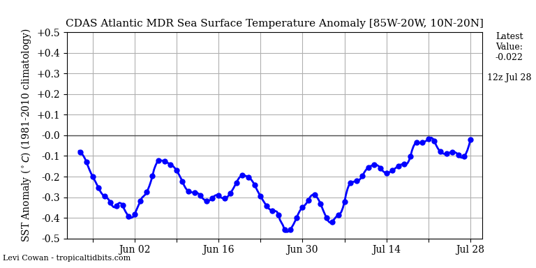
Amazingly, the Caribbean still warmed albeit only slightly in these years that warmed a lot in the summer. The biggest changes occurred in the eastern Atlantic but the entire MDR as a whole warmed. These years that warmed the most in the MDR started off from a significantly cooler base state in the spring.

MAM SST difference years that warmed the most in the MDR - years that cooled the most in the MDR
Image


JJA SST difference years that warmed the most in the MDR - years that cooled the most in the MDR
Image
4 likes   

User avatar
NotSparta
Professional-Met
Professional-Met
Posts: 1645
Age: 22
Joined: Fri Aug 18, 2017 8:24 am
Location: Naples, FL
Contact:

Re: 2018 Indicators: SST's / MSLP / Sal / Steering / Shear / Instability (Graphic updates at first post)

#549 Postby NotSparta » Thu Jul 12, 2018 12:55 pm

This huge tropical wave is a great demonstration of how the active WAM will slow the trades over the MDR.

On the southern side of these waves, trade winds are suppressed significantly, and as they pass, you're left with SW wind anoms.

Image
3 likes   
This post was probably an opinion of mine, and in no way is official. Please refer to http://www.hurricanes.gov for official tropical analysis and advisories.

My website, with lots of tropical wx graphics, including satellite and recon: http://cyclonicwx.com

User avatar
SoupBone
Category 5
Category 5
Posts: 3073
Joined: Tue Sep 20, 2005 5:24 pm

Re: 2018 Indicators: SST's / MSLP / Sal / Steering / Shear / Instability (Graphic updates at first post)

#550 Postby SoupBone » Thu Jul 12, 2018 12:59 pm

NotSparta wrote:This huge tropical wave is a great demonstration of how the active WAM will slow the trades over the MDR.

On the southern side of these waves, trade winds are suppressed significantly, and as they pass, you're left with SW wind anoms.


Beyond weaker steering of systems, what other affect will these potentially have?
1 likes   
Personal Forecast Disclaimer:
The posts in this forum are NOT official forecast and should not be used as such. They are just the opinion of the poster and may or may not be backed by sound meteorological data. They are NOT endorsed by any professional institution or storm2k.org. For official information, please refer to the NHC and NWS products.

User avatar
NotSparta
Professional-Met
Professional-Met
Posts: 1645
Age: 22
Joined: Fri Aug 18, 2017 8:24 am
Location: Naples, FL
Contact:

Re: 2018 Indicators: SST's / MSLP / Sal / Steering / Shear / Instability (Graphic updates at first post)

#551 Postby NotSparta » Thu Jul 12, 2018 1:03 pm

SoupBone wrote:
NotSparta wrote:This huge tropical wave is a great demonstration of how the active WAM will slow the trades over the MDR.

On the southern side of these waves, trade winds are suppressed significantly, and as they pass, you're left with SW wind anoms.


Beyond weaker steering of systems, what other affect will these potentially have?


Causes warming of the MDR, which we are seeing currently
0 likes   
This post was probably an opinion of mine, and in no way is official. Please refer to http://www.hurricanes.gov for official tropical analysis and advisories.

My website, with lots of tropical wx graphics, including satellite and recon: http://cyclonicwx.com

User avatar
KimmieLa
S2K Supporter
S2K Supporter
Posts: 98
Joined: Fri May 25, 2012 10:38 pm
Location: Baton Rouge, LA

Re: 2018 Indicators: SST's / MSLP / Sal / Steering / Shear / Instability (Graphic updates at first post)

#552 Postby KimmieLa » Thu Jul 12, 2018 2:41 pm

NotSparta wrote:
SoupBone wrote:
NotSparta wrote:This huge tropical wave is a great demonstration of how the active WAM will slow the trades over the MDR.

On the southern side of these waves, trade winds are suppressed significantly, and as they pass, you're left with SW wind anoms.


Beyond weaker steering of systems, what other affect will these potentially have?


Causes warming of the MDR, which we are seeing currently


So, does this mean that there will be no El Nino for awhile? Or, do I have this backwards??
0 likes   

tolakram
Admin
Admin
Posts: 19165
Age: 60
Joined: Sun Aug 27, 2006 8:23 pm
Location: Florence, KY (name is Mark)

Re: 2018 Indicators: SST's / MSLP / Sal / Steering / Shear / Instability (Graphic updates at first post)

#553 Postby tolakram » Thu Jul 12, 2018 3:30 pm

This is Atlantic sea surface temps which have no bearing on el nino. Pacific waters in the nino regions are slowly warming and it appears there will be an el nino by winter, possibly by fall.
2 likes   
M a r k
- - - - -
Join us in chat: Storm2K Chatroom Invite. Android and IOS apps also available.

The posts in this forum are NOT official forecasts and should not be used as such. Posts are NOT endorsed by any professional institution or STORM2K.org. For official information and forecasts, please refer to NHC and NWS products.

User avatar
NotSparta
Professional-Met
Professional-Met
Posts: 1645
Age: 22
Joined: Fri Aug 18, 2017 8:24 am
Location: Naples, FL
Contact:

Re: 2018 Indicators: SST's / MSLP / Sal / Steering / Shear / Instability (Graphic updates at first post)

#554 Postby NotSparta » Thu Jul 12, 2018 3:46 pm

tolakram wrote:This is Atlantic sea surface temps which have no bearing on el nino. Pacific waters in the nino regions are slowly warming and it appears there will be an el nino by winter, possibly by fall.


There is some bearing on ENSO, the warmer TATL would tend to suppress an El Niño. They can still occur if other factors are in favor of one, though.
3 likes   
This post was probably an opinion of mine, and in no way is official. Please refer to http://www.hurricanes.gov for official tropical analysis and advisories.

My website, with lots of tropical wx graphics, including satellite and recon: http://cyclonicwx.com

User avatar
Kingarabian
S2K Supporter
S2K Supporter
Posts: 15433
Joined: Sat Aug 08, 2009 3:06 am
Location: Honolulu, Hawaii

Re: 2018 Indicators: SST's / MSLP / Sal / Steering / Shear / Instability (Graphic updates at first post)

#555 Postby Kingarabian » Thu Jul 12, 2018 4:27 pm

Some good chatter on Twitter from Dr. Ventrice and Dr.Klotzbach in regards to the trades:

 https://twitter.com/philklotzbach/status/1017393639453089792


1 likes   
RIP Kobe Bryant

Eric Webb
Tropical Storm
Tropical Storm
Posts: 154
Joined: Fri Mar 13, 2015 10:42 pm
Contact:

Re: 2018 Indicators: SST's / MSLP / Sal / Steering / Shear / Instability (Graphic updates at first post)

#556 Postby Eric Webb » Thu Jul 12, 2018 5:27 pm

If the EPS is correct, the easterly trade winds will be even weaker the rest of July over the Atlantic MDR than what we've seen the past few weeks. This favors continued warming of the MDR for the foreseeable future in spite of MJO interference. Really interested to see what will happen the next time subseasonal forcing aligns over the Atlantic, Africa, and the Indian Ocean.

Image
5 likes   

User avatar
Kingarabian
S2K Supporter
S2K Supporter
Posts: 15433
Joined: Sat Aug 08, 2009 3:06 am
Location: Honolulu, Hawaii

Re: 2018 Indicators: SST's / MSLP / Sal / Steering / Shear / Instability (Graphic updates at first post)

#557 Postby Kingarabian » Thu Jul 12, 2018 5:30 pm

Eric Webb wrote:If the EPS is correct, the easterly trade winds will be even weaker the rest of July over the Atlantic MDR than what we've seen the past few weeks. This favors continued warming of the MDR for the foreseeable future in spite of MJO interference. Really interested to see what will happen the next time subseasonal forcing aligns over the Atlantic, Africa, and the Indian Ocean.

[img]https://pbs.twimg.com/media/Dh6HwjVWsAAyS3o.jpg:large[mg]


Unless the MJO sits in the EPAC, it'll likely be around the 2nd week of August when favorable VP200 anomalies enter the GOM/Atlantic.
1 likes   
RIP Kobe Bryant

User avatar
NotSparta
Professional-Met
Professional-Met
Posts: 1645
Age: 22
Joined: Fri Aug 18, 2017 8:24 am
Location: Naples, FL
Contact:

Re: 2018 Indicators: SST's / MSLP / Sal / Steering / Shear / Instability (Graphic updates at first post)

#558 Postby NotSparta » Thu Jul 12, 2018 5:51 pm

Eric Webb wrote:If the EPS is correct, the easterly trade winds will be even weaker the rest of July over the Atlantic MDR than what we've seen the past few weeks. This favors continued warming of the MDR for the foreseeable future in spite of MJO interference. Really interested to see what will happen the next time subseasonal forcing aligns over the Atlantic, Africa, and the Indian Ocean.

[img]https://pbs.twimg.com/media/Dh6HwjVWsAAyS3o.jpg:large[img]


Seems it comes around to a favorable state by about mid-August

Image
3 likes   
This post was probably an opinion of mine, and in no way is official. Please refer to http://www.hurricanes.gov for official tropical analysis and advisories.

My website, with lots of tropical wx graphics, including satellite and recon: http://cyclonicwx.com

User avatar
NotSparta
Professional-Met
Professional-Met
Posts: 1645
Age: 22
Joined: Fri Aug 18, 2017 8:24 am
Location: Naples, FL
Contact:

Re: 2018 Indicators: SST's / MSLP / Sal / Steering / Shear / Instability (Graphic updates at first post)

#559 Postby NotSparta » Thu Jul 12, 2018 9:45 pm

CFS is trending lower w/ MDR pressures for August.

Image
2 likes   
This post was probably an opinion of mine, and in no way is official. Please refer to http://www.hurricanes.gov for official tropical analysis and advisories.

My website, with lots of tropical wx graphics, including satellite and recon: http://cyclonicwx.com

AutoPenalti
Category 5
Category 5
Posts: 3949
Age: 27
Joined: Mon Aug 17, 2015 4:16 pm
Location: Ft. Lauderdale, Florida

Re: 2018 Indicators: SST's / MSLP / Sal / Steering / Shear / Instability (Graphic updates at first post)

#560 Postby AutoPenalti » Thu Jul 12, 2018 10:24 pm

NotSparta wrote:CFS is trending lower w/ MDR pressures for August.

https://i.imgur.com/mRXSUVU.gif

Looks like it's going to perfectly coincide with the active part of the season (Aug-Sept).
1 likes   
The posts in this forum are NOT official forecasts and should not be used as such. They are just the opinion of the poster and may or may not be backed by sound meteorological data. They are NOT endorsed by any professional institution or STORM2K. For official information, please refer to products from the NHC and NWS.


Model Runs Cheat Sheet:
GFS (5:30 AM/PM, 11:30 AM/PM)
HWRF, GFDL, UKMET, NAVGEM (6:30-8:00 AM/PM, 12:30-2:00 AM/PM)
ECMWF (1:45 AM/PM)

TCVN
is a weighted averaged


Return to “Talkin' Tropics”

Who is online

Users browsing this forum: Brent, Hurricane2022, tolakram, zzzh and 128 guests