2018 Indicators: SST's / MSLP / Sal / Steering / Shear / Instability (Graphic updates at first post)

This is the general tropical discussion area. Anyone can take their shot at predicting a storms path.

Moderator: S2k Moderators

Forum rules

The posts in this forum are NOT official forecasts and should not be used as such. They are just the opinion of the poster and may or may not be backed by sound meteorological data. They are NOT endorsed by any professional institution or STORM2K. For official information, please refer to products from the National Hurricane Center and National Weather Service.

Help Support Storm2K
Message
Author
User avatar
BYG Jacob
Category 3
Category 3
Posts: 893
Age: 26
Joined: Wed Aug 23, 2017 3:46 pm
Location: Tucson, Arizona

Re: 2018 Indicators: SST's / MSLP / Sal / Steering / Shear / Instability (Graphic updates at first post)

#581 Postby BYG Jacob » Fri Jul 13, 2018 10:26 pm

Alyono wrote:
Hypercane_Kyle wrote:Worth pointing out that 2009, despite being relatively inactive, turned two of the most impressive El Nino year CV hurricanes in the last decade: Hurricanes Bill and Fred.


Frances and Ivan have those two covered

Ivanhater to the white courtesy phone please
0 likes   

Eric Webb
Tropical Storm
Tropical Storm
Posts: 154
Joined: Fri Mar 13, 2015 10:42 pm
Contact:

Re: 2018 Indicators: SST's / MSLP / Sal / Steering / Shear / Instability (Graphic updates at first post)

#582 Postby Eric Webb » Fri Jul 13, 2018 10:31 pm

Kingarabian wrote:
NotSparta wrote:
Kingarabian wrote:
To be fair its not just the Euro, the JMA and CFS show the same thing.


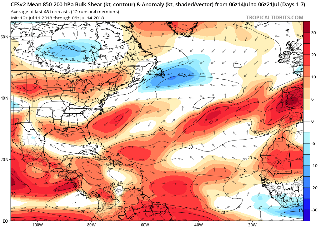
Then something is wrong with all these models wrt the WAM, you don't go from near record territory to much drier than normal in a timeframe like a week or two


I think they're behaving normally when you consider the subsurface pool in the CPAC/EPAC, and the MJO modeled to enter and become "stuck" in the El Nino phases.

It's all wait and see at this point. Mid August will be telling. Eric Blake and Levi Cowan do have a point that this may only be a small 2 week trend in the grand scheme of things.


Levi Cowan and Eric Blake made this statement because they thought the lack of strong, persistent easterly trades was being driven by subseasonal variability. It's extremely obvious with the MJO in the central-western pacific that what we're observing still shouldn't be happening if this was the case, and the next 10 days the trades are going to only get slower even as the east-central MDR appears dry. The drier MDR is arguably even more conducive for more rapid warming because it benefits from both weak trades underneath the AEWs on the northern side of the AEJ and increased insolation that both serve to warm the sea surface, obviously the advection of SAL does block some insolation but this is offset by the lack of large-scale deep convective cloud cover.

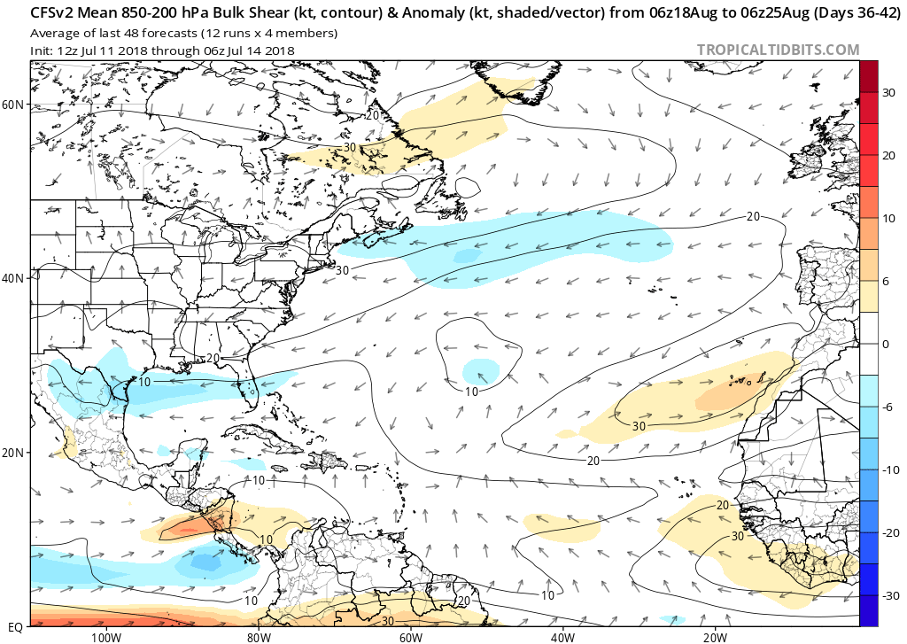
I'll say this again, what we are seeing is not temporary because the trade wind variability is being driven by the monsoon (which is a lower frequency, seasonal phenomena and not higher frequency subseasonal forcing (CCKWs/MJO (which both argue for strong trades over the Atlantic atm). Even these big, poleward displaced, dry waves the next week or two (and possibly beyond) will probably inflict quite a bit of damage to the -AMO as the ECMWF shows...

Image
9 likes   

User avatar
Kingarabian
S2K Supporter
S2K Supporter
Posts: 15432
Joined: Sat Aug 08, 2009 3:06 am
Location: Honolulu, Hawaii

Re: 2018 Indicators: SST's / MSLP / Sal / Steering / Shear / Instability (Graphic updates at first post)

#583 Postby Kingarabian » Sat Jul 14, 2018 1:05 am

:uarrow:

Would African waves crossing into the EPAC also slow trades?
1 likes   
RIP Kobe Bryant

User avatar
NotSparta
Professional-Met
Professional-Met
Posts: 1645
Age: 22
Joined: Fri Aug 18, 2017 8:24 am
Location: Naples, FL
Contact:

Re: 2018 Indicators: SST's / MSLP / Sal / Steering / Shear / Instability (Graphic updates at first post)

#584 Postby NotSparta » Sat Jul 14, 2018 1:10 am

Kingarabian wrote::uarrow:

Would African waves crossing into the EPAC also slow trades?


If they still have strong spin when they have crossed, yes.
2 likes   
This post was probably an opinion of mine, and in no way is official. Please refer to http://www.hurricanes.gov for official tropical analysis and advisories.

My website, with lots of tropical wx graphics, including satellite and recon: http://cyclonicwx.com

User avatar
gatorcane
S2K Supporter
S2K Supporter
Posts: 23499
Age: 46
Joined: Sun Mar 13, 2005 3:54 pm
Location: Boca Raton, FL

Re: 2018 Indicators: SST's / MSLP / Sal / Steering / Shear / Instability (Graphic updates at first post)Aa

#585 Postby gatorcane » Sat Jul 14, 2018 12:43 pm

NotSparta wrote:
Eric Webb wrote:If the EPS is correct, the easterly trade winds will be even weaker the rest of July over the Atlantic MDR than what we've seen the past few weeks. This favors continued warming of the MDR for the foreseeable future in spite of MJO interference. Really interested to see what will happen the next time subseasonal forcing aligns over the Atlantic, Africa, and the Indian Ocean.

[img]https://pbs.twimg.com/media/Dh6HwjVWsAAyS3o.jpg:large[img]


Seems it comes around to a favorable state by about mid-August

https://i.imgur.com/1tEvp6w.gif


The long-range CFS also shows much lower shear anomalies across the entire Atlantic basin come mid to late August compared to now. Wet-phase of MJO + low shear (+possibly warmer than normal SSTs based on latest trends) would mean a favorable setup for development across the MDR. See images below:

Now:
Image

Mid-late August:
Image
0 likes   

User avatar
cycloneye
Admin
Admin
Posts: 139008
Age: 67
Joined: Thu Oct 10, 2002 10:54 am
Location: San Juan, Puerto Rico

Re: 2018 Indicators: SST's / MSLP / Sal / Steering / Shear / Instability (Graphic updates at first post)

#586 Postby cycloneye » Mon Jul 16, 2018 8:42 am

@MJVentrice
Models are calling for a strong convectively coupled Kelvin wave to pass the Atlantic and Africa regions during the final days of July into the first week of August. This wave could produce some things to monitor over the Atlantic during early August.


Image

 https://twitter.com/MJVentrice/status/1018852529407496193


1 likes   
Visit the Caribbean-Central America Weather Thread where you can find at first post web cams,radars
and observations from Caribbean basin members Click Here

User avatar
TheStormExpert
Category 5
Category 5
Posts: 8487
Age: 30
Joined: Wed Feb 16, 2011 5:38 pm
Location: Palm Beach Gardens, FL

Re: 2018 Indicators: SST's / MSLP / Sal / Steering / Shear / Instability (Graphic updates at first post)

#587 Postby TheStormExpert » Mon Jul 16, 2018 8:48 am

:uarrow: I believe the GFS may be starting to pick up on this as in the first day of August it shows something in the Eastern GoM.
0 likes   
The following post is NOT an official forecast and should not be used as such. It is just the opinion of the poster and may or may not be backed by sound meteorological data. It is NOT endorsed by storm2k.org.

User avatar
GCANE
S2K Supporter
S2K Supporter
Posts: 10787
Joined: Mon Oct 22, 2007 8:03 am

Re: 2018 Indicators: SST's / MSLP / Sal / Steering / Shear / Instability (Graphic updates at first post)

#588 Postby GCANE » Mon Jul 16, 2018 1:34 pm

GFS is forecasting the Bermuda High to kick in early next week.
0 likes   

User avatar
wxGuy
Tropical Storm
Tropical Storm
Posts: 104
Joined: Thu Jun 14, 2018 1:50 pm

Re: 2018 Indicators: SST's / MSLP / Sal / Steering / Shear / Instability (Graphic updates at first post)

#589 Postby wxGuy » Mon Jul 16, 2018 1:49 pm

Kelvin waves favor tropical cyclogenesis three days after their peak convection, let's see what it has to offer
0 likes   

User avatar
cycloneye
Admin
Admin
Posts: 139008
Age: 67
Joined: Thu Oct 10, 2002 10:54 am
Location: San Juan, Puerto Rico

Re: 2018 Indicators: SST's / MSLP / Sal / Steering / Shear / Instability (Graphic updates at first post)

#590 Postby cycloneye » Mon Jul 16, 2018 2:13 pm

The July update from ECMWF of MSLP for ASO shows higher pressures almost everywhere in the North Atlantic basin.

In July 2017 it was very different.

Image

Image
0 likes   
Visit the Caribbean-Central America Weather Thread where you can find at first post web cams,radars
and observations from Caribbean basin members Click Here

User avatar
NotSparta
Professional-Met
Professional-Met
Posts: 1645
Age: 22
Joined: Fri Aug 18, 2017 8:24 am
Location: Naples, FL
Contact:

Re: 2018 Indicators: SST's / MSLP / Sal / Steering / Shear / Instability (Graphic updates at first post)

#591 Postby NotSparta » Mon Jul 16, 2018 2:29 pm

cycloneye wrote:The July update from ECMWF of MSLP for ASO shows higher pressures almost everywhere in the North Atlantic basin.

In July 2017 it was very different.

[img]https://i.imgur.com/v2Q1Nvg.png[img]

[img]https://i.imgur.com/qvhieul.png[img]


Where are these forecasts located?
0 likes   
This post was probably an opinion of mine, and in no way is official. Please refer to http://www.hurricanes.gov for official tropical analysis and advisories.

My website, with lots of tropical wx graphics, including satellite and recon: http://cyclonicwx.com

User avatar
SFLcane
S2K Supporter
S2K Supporter
Posts: 9606
Age: 46
Joined: Sat Jun 05, 2010 1:44 pm
Location: Lake Worth Florida

Re: 2018 Indicators: SST's / MSLP / Sal / Steering / Shear / Instability (Graphic updates at first post)

#592 Postby SFLcane » Mon Jul 16, 2018 2:51 pm

cycloneye wrote:The July update from ECMWF of MSLP for ASO shows higher pressures almost everywhere in the North Atlantic basin.

In July 2017 it was very different.

Image

Image


Lol oh boy a complete shut down.. :roll:
0 likes   

User avatar
CyclonicFury
Category 5
Category 5
Posts: 1970
Age: 25
Joined: Sun Jul 02, 2017 12:32 pm
Location: NC
Contact:

Re: 2018 Indicators: SST's / MSLP / Sal / Steering / Shear / Instability (Graphic updates at first post)

#593 Postby CyclonicFury » Mon Jul 16, 2018 2:53 pm

SFLcane wrote:
cycloneye wrote:The July update from ECMWF of MSLP for ASO shows higher pressures almost everywhere in the North Atlantic basin.

In July 2017 it was very different.

Image

Image


Lol oh boy a complete shut down.. :roll:

The Euro has a high bias when it comes to Atlantic SLP. The CFS shows near-average pressures in the Atlantic for ASO, but I think it may have a low bias (not sure about that).
0 likes   
NCSU B.S. in Meteorology Class of 2021. Tropical weather blogger at http://www.cyclonicfury.com. My forecasts and thoughts are NOT official, for official forecasts please consult the National Hurricane Center.

Alyono
Professional-Met
Professional-Met
Posts: 6961
Joined: Fri Apr 26, 2013 3:52 pm
Location: Texas Coast

Re: 2018 Indicators: SST's / MSLP / Sal / Steering / Shear / Instability (Graphic updates at first post)

#594 Postby Alyono » Mon Jul 16, 2018 2:56 pm

EC forecast is for

Starting August 1
8.6 TS (SD of 2.8)
4.6 H (SD of 1.8)

That means, assuming no additional development in July, EC is basically going for 12/7 However, it could easily be as much as 13/8
2 likes   

User avatar
CyclonicFury
Category 5
Category 5
Posts: 1970
Age: 25
Joined: Sun Jul 02, 2017 12:32 pm
Location: NC
Contact:

Re: 2018 Indicators: SST's / MSLP / Sal / Steering / Shear / Instability (Graphic updates at first post)

#595 Postby CyclonicFury » Mon Jul 16, 2018 2:59 pm

Alyono wrote:EC forecast is for

Starting August 1
8.6 TS (SD of 2.8)
4.6 H (SD of 1.8)

That means, assuming no additional development in July, EC is basically going for 12/7 However, it could easily be as much as 13/8

Isn't that more than the last forecast? IIRC Wxman said the last forecast only called for about 7 NS and 3 H.
0 likes   
NCSU B.S. in Meteorology Class of 2021. Tropical weather blogger at http://www.cyclonicfury.com. My forecasts and thoughts are NOT official, for official forecasts please consult the National Hurricane Center.

AutoPenalti
Category 5
Category 5
Posts: 3949
Age: 27
Joined: Mon Aug 17, 2015 4:16 pm
Location: Ft. Lauderdale, Florida

Re: 2018 Indicators: SST's / MSLP / Sal / Steering / Shear / Instability (Graphic updates at first post)

#596 Postby AutoPenalti » Mon Jul 16, 2018 3:00 pm

GCANE wrote:GFS is forecasting the Bermuda High to kick in early next week.

Yep, just in time for August.

Maybe we’ll get a long-trek CV?
0 likes   
The posts in this forum are NOT official forecasts and should not be used as such. They are just the opinion of the poster and may or may not be backed by sound meteorological data. They are NOT endorsed by any professional institution or STORM2K. For official information, please refer to products from the NHC and NWS.


Model Runs Cheat Sheet:
GFS (5:30 AM/PM, 11:30 AM/PM)
HWRF, GFDL, UKMET, NAVGEM (6:30-8:00 AM/PM, 12:30-2:00 AM/PM)
ECMWF (1:45 AM/PM)

TCVN
is a weighted averaged

LarryWx
Category 5
Category 5
Posts: 5694
Joined: Sun Sep 07, 2003 2:04 pm
Location: GA

Re: 2018 Indicators: SST's / MSLP / Sal / Steering / Shear / Instability (Graphic updates at first post)

#597 Postby LarryWx » Mon Jul 16, 2018 3:04 pm

CyclonicFury wrote:
SFLcane wrote:
cycloneye wrote:The July update from ECMWF of MSLP for ASO shows higher pressures almost everywhere in the North Atlantic basin.

In July 2017 it was very different.

Image

Image


Lol oh boy a complete shut down.. :roll:

The Euro has a high bias when it comes to Atlantic SLP. The CFS shows near-average pressures in the Atlantic for ASO, but I think it may have a low bias (not sure about that).


I think the Euro in general tends to have a high bias with SLPs, but not nearly enough to overcome these very high pressures in this forecast. These pressures are off the chart high.
So, even after taking into account bias, the forecast would still be for above normal SLPs.
0 likes   
Personal Forecast Disclaimer:
The posts in this forum are NOT official forecasts and should not be used as such. They are just the opinion of the poster and may or may not be backed by sound meteorological data. They are NOT endorsed by any professional institution or storm2k.org. For official information, please refer to the NHC and NWS products.

User avatar
cycloneye
Admin
Admin
Posts: 139008
Age: 67
Joined: Thu Oct 10, 2002 10:54 am
Location: San Juan, Puerto Rico

Re: 2018 Indicators: SST's / MSLP / Sal / Steering / Shear / Instability (Graphic updates at first post)

#598 Postby cycloneye » Mon Jul 16, 2018 3:04 pm

NotSparta wrote:
cycloneye wrote:The July update from ECMWF of MSLP for ASO shows higher pressures almost everywhere in the North Atlantic basin.

In July 2017 it was very different.

[img]https://i.imgur.com/v2Q1Nvg.png[img]

[img]https://i.imgur.com/qvhieul.png[img]


Where are these forecasts located?


Here is the link.

https://www.ecmwf.int/en/forecasts/charts/catalogue/seasonal_system5_public_standard_mslp?facets=Range,Long%20(Months)&time=2017070100,744,2017080100&stats=tsum
Last edited by tolakram on Mon Jul 16, 2018 3:39 pm, edited 1 time in total.
Reason: added URL tags to fix link
1 likes   
Visit the Caribbean-Central America Weather Thread where you can find at first post web cams,radars
and observations from Caribbean basin members Click Here

User avatar
SoupBone
Category 5
Category 5
Posts: 3073
Joined: Tue Sep 20, 2005 5:24 pm

Re: 2018 Indicators: SST's / MSLP / Sal / Steering / Shear / Instability (Graphic updates at first post)

#599 Postby SoupBone » Mon Jul 16, 2018 3:08 pm

GCANE wrote:GFS is forecasting the Bermuda High to kick in early next week.


The Bermuda High is an almost constant feature though. Do you mean it's forecast to build west?
1 likes   
Personal Forecast Disclaimer:
The posts in this forum are NOT official forecast and should not be used as such. They are just the opinion of the poster and may or may not be backed by sound meteorological data. They are NOT endorsed by any professional institution or storm2k.org. For official information, please refer to the NHC and NWS products.

LarryWx
Category 5
Category 5
Posts: 5694
Joined: Sun Sep 07, 2003 2:04 pm
Location: GA

Re: 2018 Indicators: SST's / MSLP / Sal / Steering / Shear / Instability (Graphic updates at first post)

#600 Postby LarryWx » Mon Jul 16, 2018 3:08 pm

Per that Euro ASO forecast, be extra vigilant in Hawaii!
1 likes   
Personal Forecast Disclaimer:
The posts in this forum are NOT official forecasts and should not be used as such. They are just the opinion of the poster and may or may not be backed by sound meteorological data. They are NOT endorsed by any professional institution or storm2k.org. For official information, please refer to the NHC and NWS products.


Return to “Talkin' Tropics”

Who is online

Users browsing this forum: chaser1, Chris90 and 50 guests