2018 Indicators: SST's / MSLP / Sal / Steering / Shear / Instability (Graphic updates at first post)
Moderator: S2k Moderators
Forum rules
The posts in this forum are NOT official forecasts and should not be used as such. They are just the opinion of the poster and may or may not be backed by sound meteorological data. They are NOT endorsed by any professional institution or STORM2K. For official information, please refer to products from the National Hurricane Center and National Weather Service.
Re: 2018 Indicators: SST's / MSLP / Sal / Steering / Shear / Instability (Graphic updates at first post)
Certainly a decent start, I expected a Chris type storm, they are fairly common in July in developing El Nino seasons, though this one may go further than most. Beryl probably more impressive in terms of location. Chris is Kinda not dissimilar to Hurricane Bill in 1997, but stronger.
Talking of 97, that also had a rapid start with 5/2/0 by end of July.. and that ended up being a very slow season thereafter...of course that had a beastly El Nino developing, but it goes to show a quick start doesn't mean much...and often neither does a slow...
Talking of 97, that also had a rapid start with 5/2/0 by end of July.. and that ended up being a very slow season thereafter...of course that had a beastly El Nino developing, but it goes to show a quick start doesn't mean much...and often neither does a slow...
2 likes
Personal Forecast Disclaimer:
The posts in this forum are NOT official forecast and should not be used as such. They are just the opinion of the poster and may or may not be backed by sound meteorological data. They are NOT endorsed by any professional institution or storm2k.org. For official information, please refer to the NHC and NWS products
The posts in this forum are NOT official forecast and should not be used as such. They are just the opinion of the poster and may or may not be backed by sound meteorological data. They are NOT endorsed by any professional institution or storm2k.org. For official information, please refer to the NHC and NWS products
-
AutoPenalti
- Category 5

- Posts: 3949
- Age: 27
- Joined: Mon Aug 17, 2015 4:16 pm
- Location: Ft. Lauderdale, Florida
Re: 2018 Indicators: SST's / MSLP / Sal / Steering / Shear / Instability (Graphic updates at first post)
Kingarabian wrote::uarrow:
Agreed. This Euro forecast is for ASO basically.
Is it me or has the Euro been subpar so far this season?
2 likes
The posts in this forum are NOT official forecasts and should not be used as such. They are just the opinion of the poster and may or may not be backed by sound meteorological data. They are NOT endorsed by any professional institution or STORM2K. For official information, please refer to products from the NHC and NWS.
Model Runs Cheat Sheet:
GFS (5:30 AM/PM, 11:30 AM/PM)
HWRF, GFDL, UKMET, NAVGEM (6:30-8:00 AM/PM, 12:30-2:00 AM/PM)
ECMWF (1:45 AM/PM)
TCVN is a weighted averaged
- TheStormExpert
- Category 5

- Posts: 8487
- Age: 30
- Joined: Wed Feb 16, 2011 5:38 pm
- Location: Palm Beach Gardens, FL
Re: 2018 Indicators: SST's / MSLP / Sal / Steering / Shear / Instability (Graphic updates at first post)
AutoPenalti wrote:Kingarabian wrote::uarrow:
Agreed. This Euro forecast is for ASO basically.
Is it me or has the Euro been subpar so far this season?
You’re not alone. The Euro has been performing very poorly so far this season. Didn’t even pickup Hurricanes Beryl or Chris and it had been too far west with Alberto and I think it also was off on intensity as well with Alberto.
1 likes
The following post is NOT an official forecast and should not be used as such. It is just the opinion of the poster and may or may not be backed by sound meteorological data. It is NOT endorsed by storm2k.org.
- NotSparta
- Professional-Met

- Posts: 1647
- Age: 22
- Joined: Fri Aug 18, 2017 8:24 am
- Location: Naples, FL
- Contact:
Re: 2018 Indicators: SST's / MSLP / Sal / Steering / Shear / Instability (Graphic updates at first post)
TheStormExpert wrote:AutoPenalti wrote:Kingarabian wrote::uarrow:
Agreed. This Euro forecast is for ASO basically.
Is it me or has the Euro been subpar so far this season?
You’re not alone. The Euro has been performing very poorly so far this season. Didn’t even pickup Hurricanes Beryl or Chris and it had been too far west with Alberto and I think it also was off on intensity as well with Alberto.
Was picking up bogus cyclones from the end of fronts too. That upgrade didn't help it
1 likes
This post was probably an opinion of mine, and in no way is official. Please refer to http://www.hurricanes.gov for official tropical analysis and advisories.
My website, with lots of tropical wx graphics, including satellite and recon: http://cyclonicwx.com
My website, with lots of tropical wx graphics, including satellite and recon: http://cyclonicwx.com
Re: 2018 Indicators: SST's / MSLP / Sal / Steering / Shear / Instability (Graphic updates at first post)
I sure wouldn't use the EC seasonal forecast when it is been brutal in past years. That warm bias it has in the Pacific leads to a sinking air and high pressure bias over the tropical Atlantic
6 likes
Re: 2018 Indicators: SST's / MSLP / Sal / Steering / Shear / Instability (Graphic updates at first post)
KWT wrote:Certainly a decent start, I expected a Chris type storm, they are fairly common in July in developing El Nino seasons, though this one may go further than most. Beryl probably more impressive in terms of location. Chris is Kinda not dissimilar to Hurricane Bill in 1997, but stronger.
Talking of 97, that also had a rapid start with 5/2/0 by end of July.. and that ended up being a very slow season thereafter...of course that had a beastly El Nino developing, but it goes to show a quick start doesn't mean much...and often neither does a slow...
1997 also had zero storms forming in the MDR (including the Caribbean)
This year has had 2, including 1 hurricane. More akin to 2008, which had 2 MDR storms through July, both of which became hurricanes
0 likes
- Kingarabian
- S2K Supporter

- Posts: 15434
- Joined: Sat Aug 08, 2009 3:06 am
- Location: Honolulu, Hawaii
Re: 2018 Indicators: SST's / MSLP / Sal / Steering / Shear / Instability (Graphic updates at first post)
Alyono wrote:KWT wrote:Certainly a decent start, I expected a Chris type storm, they are fairly common in July in developing El Nino seasons, though this one may go further than most. Beryl probably more impressive in terms of location. Chris is Kinda not dissimilar to Hurricane Bill in 1997, but stronger.
Talking of 97, that also had a rapid start with 5/2/0 by end of July.. and that ended up being a very slow season thereafter...of course that had a beastly El Nino developing, but it goes to show a quick start doesn't mean much...and often neither does a slow...
1997 also had zero storms forming in the MDR (including the Caribbean)
This year has had 2, including 1 hurricane. More akin to 2008, which had 2 MDR storms through July, both of which became hurricanes
A TC is a TC, but Beryl still seems freakish to me. Its unique small size allowed it to shield itself from the SAL, and also helped it to strengthen more than expected. A typical normal sized system likely would've ingested more SAL.
0 likes
RIP Kobe Bryant
- TheStormExpert
- Category 5

- Posts: 8487
- Age: 30
- Joined: Wed Feb 16, 2011 5:38 pm
- Location: Palm Beach Gardens, FL
Re: 2018 Indicators: SST's / MSLP / Sal / Steering / Shear / Instability (Graphic updates at first post)
Kingarabian wrote:Alyono wrote:KWT wrote:Certainly a decent start, I expected a Chris type storm, they are fairly common in July in developing El Nino seasons, though this one may go further than most. Beryl probably more impressive in terms of location. Chris is Kinda not dissimilar to Hurricane Bill in 1997, but stronger.
Talking of 97, that also had a rapid start with 5/2/0 by end of July.. and that ended up being a very slow season thereafter...of course that had a beastly El Nino developing, but it goes to show a quick start doesn't mean much...and often neither does a slow...
1997 also had zero storms forming in the MDR (including the Caribbean)
This year has had 2, including 1 hurricane. More akin to 2008, which had 2 MDR storms through July, both of which became hurricanes
A TC is a TC, but Beryl still seems freakish to me. Its unique small size allowed it to shield itself from the SAL, and also helped it to strengthen more than expected. A typical normal sized system likely would've ingested more SAL.
It’s quite normal to see significant SAL outbreaks in July in the Tropical Atlantic. Last season is a good example of why you can’t use this as an early indicator.
Now with Chris reaching and being the 2nd hurricane of the 2018 season on only July 10th I think it’s safe to say that those forecasting only an additional 2 more hurricanes are likely to be too low. I’d lean towards 6 hurricanes this season and IF Chris can reach major status which seems quite possible then I’d go with 3-4 majors in total.
1 likes
The following post is NOT an official forecast and should not be used as such. It is just the opinion of the poster and may or may not be backed by sound meteorological data. It is NOT endorsed by storm2k.org.
- Hurricaneman
- Category 5

- Posts: 7281
- Age: 43
- Joined: Tue Aug 31, 2004 3:24 pm
- Location: central florida
Re: 2018 Indicators: SST's / MSLP / Sal / Steering / Shear / Instability (Graphic updates at first post)
Best analogs I could find are 2014, 2012, and 1991 with a slight possibility of 1992 in terms of track and formation areas and where systems become their strongest and the track of Chris is similar to Arthur in 2014 but about 250 miles farther east but as we all know I’m thinking August is going to have a major hurricane head up the eastern seaboard if the pattern repeats itself like in 1991 or close calls to Bermuda like 2014 so I’m thinking a blend of 1991 and 2014 for a top analog with 2014 being tops. Due to the strong early activity I’ve dropped 1994 from my top analogs
1 likes
- Hurricaneman
- Category 5

- Posts: 7281
- Age: 43
- Joined: Tue Aug 31, 2004 3:24 pm
- Location: central florida
Re: 2018 Indicators: SST's / MSLP / Sal / Steering / Shear / Instability (Graphic updates at first post)
Another thing is that I think above 20N is going to be really busy and somethings are going to form from non tropical origins like Chris for the most part and any tropical wave north of 20 and west of 50
0 likes
-
txwatcher91
- Category 5

- Posts: 1498
- Joined: Tue Aug 02, 2005 2:29 pm
Re: 2018 Indicators: SST's / MSLP / Sal / Steering / Shear / Instability (Graphic updates at first post)
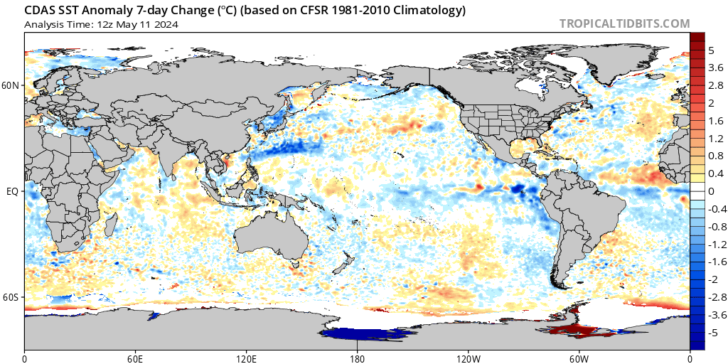
Interesting to note, there is a lot of cooling going on around the world right now with SST's, something you don't expect to see in a developing weak Nino.

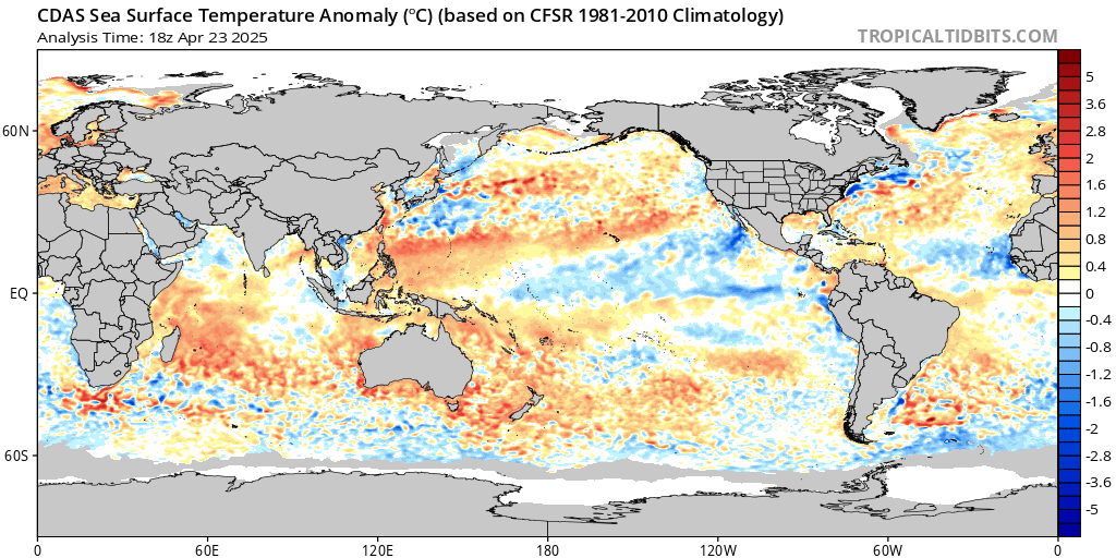
Persistent cold waters around Greenland and more of the Atlantic has cooled off in recent days.


Persistent cold waters around Greenland and more of the Atlantic has cooled off in recent days.

0 likes
- NotSparta
- Professional-Met

- Posts: 1647
- Age: 22
- Joined: Fri Aug 18, 2017 8:24 am
- Location: Naples, FL
- Contact:
Re: 2018 Indicators: SST's / MSLP / Sal / Steering / Shear / Instability (Graphic updates at first post)
txwatcher91 wrote:Interesting to note, there is a lot of cooling going on around the world right now with SST's, something you don't expect to see in a developing weak Nino.
[img]https://www.tropicaltidbits.com/analysis/ocean/cdas-sflux_ssta7diff_global_1.png[img]
Persistent cold waters around Greenland and more of the Atlantic has cooled off in recent days.
[img]https://www.tropicaltidbits.com/analysis/ocean/cdas-sflux_ssta_global_1.png[img]
That Niño 3/1+2 cool tongue looks interesting at first, but I think it has more to do w/ the phase 5 MJO, and a passing suppressive CCKW. That's more subseasonal forcing than any kind of bkg state change away from the progression to Niño. Actually, the MJO moving into phase 6 could kickstart a Niño bkg state. 2009 showed us you don't need constant WWBs for a Niño, and actually had a similar evolution w/ a large July EWB. In addition, the subsurface remains warm.
Besides, those regions are usually going to be cooler even when the Niño begins, since it doesn't seem to be totally east-based/traditional.
1 likes
This post was probably an opinion of mine, and in no way is official. Please refer to http://www.hurricanes.gov for official tropical analysis and advisories.
My website, with lots of tropical wx graphics, including satellite and recon: http://cyclonicwx.com
My website, with lots of tropical wx graphics, including satellite and recon: http://cyclonicwx.com
- NotSparta
- Professional-Met

- Posts: 1647
- Age: 22
- Joined: Fri Aug 18, 2017 8:24 am
- Location: Naples, FL
- Contact:
Re: 2018 Indicators: SST's / MSLP / Sal / Steering / Shear / Instability (Graphic updates at first post)
this month has been full of surprises
2 likes
This post was probably an opinion of mine, and in no way is official. Please refer to http://www.hurricanes.gov for official tropical analysis and advisories.
My website, with lots of tropical wx graphics, including satellite and recon: http://cyclonicwx.com
My website, with lots of tropical wx graphics, including satellite and recon: http://cyclonicwx.com
- CyclonicFury
- Category 5

- Posts: 1973
- Age: 25
- Joined: Sun Jul 02, 2017 12:32 pm
- Location: NC
- Contact:
Re: 2018 Indicators: SST's / MSLP / Sal / Steering / Shear / Instability (Graphic updates at first post)
NotSparta wrote::uarrow:
this month has been full of surprises
It certainly has. A lot of us were thinking July would be quiet (or even completely dead). I was thinking we might see one weak storm along the Gulf Stream this month, but nothing more. Instead, the Atlantic goes on to produce the earliest MDR hurricane in the satellite era (Beryl) and the strongest July hurricane in a decade (Chris). Not to mention the +PMM pattern has collapsed and the Atlantic MDR has been significantly warming recently. Proves how fast things can change in the tropics!
2 likes
NCSU B.S. in Meteorology Class of 2021. Tropical weather blogger at http://www.cyclonicfury.com. My forecasts and thoughts are NOT official, for official forecasts please consult the National Hurricane Center.
-
WeatherEmperor
- S2K Supporter

- Posts: 4806
- Age: 40
- Joined: Thu Sep 04, 2003 2:54 pm
- Location: South Florida
Re: 2018 Indicators: SST's / MSLP / Sal / Steering / Shear / Instability (Graphic updates at first post)
It looks like the PMM had collapsed somewhat. Are there any indications/forecasts that show the PMM going stronger/more positive again??
Sent from my iPhone using Tapatalk
Sent from my iPhone using Tapatalk
1 likes
- NotSparta
- Professional-Met

- Posts: 1647
- Age: 22
- Joined: Fri Aug 18, 2017 8:24 am
- Location: Naples, FL
- Contact:
Re: 2018 Indicators: SST's / MSLP / Sal / Steering / Shear / Instability (Graphic updates at first post)
WeatherEmperor wrote:It looks like the PMM had collapsed somewhat. Are there any indications/forecasts that show the PMM going stronger/more positive again??
Sent from my iPhone using Tapatalk
Climate models like to, but the GFS & CFS keep EP trades much stronger than avg, meaning a possibility for a -PMM pattern, imo
0 likes
This post was probably an opinion of mine, and in no way is official. Please refer to http://www.hurricanes.gov for official tropical analysis and advisories.
My website, with lots of tropical wx graphics, including satellite and recon: http://cyclonicwx.com
My website, with lots of tropical wx graphics, including satellite and recon: http://cyclonicwx.com
- Kingarabian
- S2K Supporter

- Posts: 15434
- Joined: Sat Aug 08, 2009 3:06 am
- Location: Honolulu, Hawaii
Re: 2018 Indicators: SST's / MSLP / Sal / Steering / Shear / Instability (Graphic updates at first post)
NotSparta wrote:WeatherEmperor wrote:It looks like the PMM had collapsed somewhat. Are there any indications/forecasts that show the PMM going stronger/more positive again??
Sent from my iPhone using Tapatalk
Climate models like to, but the GFS & CFS keep EP trades much stronger than avg, meaning a possibility for a -PMM pattern, imo
Waters W/SW of Baja California have drastically rewarmed this past week:

Also noticeably warmer so far compared to last month at this time:

1 likes
RIP Kobe Bryant
Who is online
Users browsing this forum: chaser1 and 79 guests


