Watching Western Caribbean (Is INVEST 91L)
Moderator: S2k Moderators
Forum rules

The posts in this forum are NOT official forecasts and should not be used as such. They are just the opinion of the poster and may or may not be backed by sound meteorological data. They are NOT endorsed by any professional institution or STORM2K. For official information, please refer to products from the National Hurricane Center and National Weather Service.

-
TheAustinMan

- Category 4

- Posts: 994
- Age: 24
- Joined: Mon Jul 08, 2013 4:26 pm
- Location: United States
- Contact:
Re: Watching SW Caribbean
Airmass RGB look at the disturbance, though right now what appears to be a mid-level vort/MCV seems to be stealing the show over the surface vorticity. Radar from San Andres overlaid. You can see the trough and dry conditions aloft over in the Western Caribbean.
341 KB. Source: Airmass RGB data plot generated myself. San Andres radar data from http://meteorologia.aerocivil.gov.co/radar/index/aoi/ADZ/Reflectividad%20de%20Base%200.5%20deg?scroll_x=0&scroll_y=228&menu1=%23&menu1=%5C%22%23%5C%22

341 KB. Source: Airmass RGB data plot generated myself. San Andres radar data from http://meteorologia.aerocivil.gov.co/radar/index/aoi/ADZ/Reflectividad%20de%20Base%200.5%20deg?scroll_x=0&scroll_y=228&menu1=%23&menu1=%5C%22%23%5C%22
4 likes


- Treat my opinions with a grain of salt. For official information see your local weather service.
-
Tireman4

- S2K Supporter

- Posts: 5674
- Age: 58
- Joined: Fri Jun 30, 2006 1:08 pm
- Location: Humble, Texas
- Contact:
Re: Watching SW Caribbean
ROCK wrote:06Z NAVGEM stalls at Texas coast and blows it up!!
I love the NAVY sir. ")
1 likes
Re: Watching SW Caribbean
The 12Z UKMET has no TC.
0 likes
Personal Forecast Disclaimer:
The posts in this forum are NOT official forecasts and should not be used as such. They are just the opinion of the poster and may or may not be backed by sound meteorological data. They are NOT endorsed by any professional institution or storm2k.org. For official information, please refer to the NHC and NWS products.
The posts in this forum are NOT official forecasts and should not be used as such. They are just the opinion of the poster and may or may not be backed by sound meteorological data. They are NOT endorsed by any professional institution or storm2k.org. For official information, please refer to the NHC and NWS products.

Re: Watching SW Caribbean
ROCK wrote:06Z NAVGEM stalls at Texas coast and blows it up!!
And the 12z NAVGEM just has a weak low in the BoC
0 likes
-
cycloneye

- Admin

- Posts: 139009
- Age: 67
- Joined: Thu Oct 10, 2002 10:54 am
- Location: San Juan, Puerto Rico
Re: Watching SW Caribbean
Hey folks,maybe a mention? So far no TWO as they haved released them very very early in past packages. If they dont mention,at least they are watching and discussimg among them.
1 likes
Visit the Caribbean-Central America Weather Thread where you can find at first post web cams,radars
and observations from Caribbean basin members Click Here
and observations from Caribbean basin members Click Here
Re: Watching SW Caribbean
cycloneye wrote:Hey folks,maybe a mention? So far no TWO as they haved released them very very early in past packages. If they dont mention,at least they are watching and discussimg among them.
The lack of even a mention/10% has been underdoing the risk imo. A small risk doesn't mean no risk. They seem to be acting as if it is black and white. Let's see what they do here shortly.
2 likes
Personal Forecast Disclaimer:
The posts in this forum are NOT official forecasts and should not be used as such. They are just the opinion of the poster and may or may not be backed by sound meteorological data. They are NOT endorsed by any professional institution or storm2k.org. For official information, please refer to the NHC and NWS products.
The posts in this forum are NOT official forecasts and should not be used as such. They are just the opinion of the poster and may or may not be backed by sound meteorological data. They are NOT endorsed by any professional institution or storm2k.org. For official information, please refer to the NHC and NWS products.
-
northjaxpro

- S2K Supporter
- Posts: 8900
- Joined: Mon Sep 27, 2010 11:21 am
- Location: Jacksonville, FL
Re: Watching SW Caribbean
NDG wrote:X is where I marked the MLC seen on radar off of the coast of Nicaragua tracking NNE.
https://i.imgur.com/EEyArlW.gif
That is about right NDG..A very prominent MLC there just off the Nicaragua coast.
0 likes
NEVER, EVER SAY NEVER in the tropics and weather in general, and most importantly, with life itself!!
________________________________________________________________________________________
Fay 2008 Beryl 2012 Debby 2012 Colin 2016 Hermine 2016 Julia 2016 Matthew 2016 Irma 2017 Dorian 2019
________________________________________________________________________________________
Fay 2008 Beryl 2012 Debby 2012 Colin 2016 Hermine 2016 Julia 2016 Matthew 2016 Irma 2017 Dorian 2019
-
cycloneye
- Admin
- Posts: 139009
- Age: 67
- Joined: Thu Oct 10, 2002 10:54 am
- Location: San Juan, Puerto Rico
Re: Watching SW Caribbean
Here it is!


Tropical Weather Outlook
NWS National Hurricane Center Miami FL
200 PM EDT Mon Jun 11 2018
For the North Atlantic...Caribbean Sea and the Gulf of Mexico:
A broad area of showers and thunderstorms has persisted over the
southwestern Caribbean Sea for the past several hours. This activity
is associated with a tropical wave over northwestern Venezuela and
a surface trough located just east of Nicaragua interacting with a
large upper-level trough. Little development of this area of
disturbed weather is expected over the next few days due to
interaction with Central America and the Yucatan Peninsula. However,
environmental conditions could become somewhat more conducive for
some limited development when the system moves into the southwestern
Gulf of Mexico by the end of the week. Regardless of development,
this disturbance will produce locally heavy rainfall across portions
of Nicaragua, Honduras, Belize, Guatemala, and the Yucatan Peninsula
through Thursday.
* Formation chance through 48 hours...low...10 percent.
* Formation chance through 5 days...low...20 percent.
$$
Forecaster Stewart
3 likes
Visit the Caribbean-Central America Weather Thread where you can find at first post web cams,radars
and observations from Caribbean basin members Click Here
and observations from Caribbean basin members Click Here
Re: Watching SW Caribbean
1 likes
Personal Forecast Disclaimer:
The posts in this forum are NOT official forecasts and should not be used as such. They are just the opinion of the poster and may or may not be backed by sound meteorological data. They are NOT endorsed by any professional institution or storm2k.org. For official information, please refer to the NHC and NWS products.
The posts in this forum are NOT official forecasts and should not be used as such. They are just the opinion of the poster and may or may not be backed by sound meteorological data. They are NOT endorsed by any professional institution or storm2k.org. For official information, please refer to the NHC and NWS products.
Re: Watching SW Caribbean: 2 PM TWO=10%-20%
Looks like they tagged the trailing piece of vorticity rather than the one with the clear MLC further west. GFS has been unclear as to what actually will develop out of this mess.
0 likes
-
jaguars_22
- Category 1

- Posts: 493
- Joined: Tue Jun 20, 2017 2:26 pm
Re: Watching SW Caribbean: 2 PM TWO=10%-20%
jaguars_22 wrote:Why they mark it so far down in the Caribbean??
I think because that's near the tropical wave, itself.
0 likes
Personal Forecast Disclaimer:
The posts in this forum are NOT official forecasts and should not be used as such. They are just the opinion of the poster and may or may not be backed by sound meteorological data. They are NOT endorsed by any professional institution or storm2k.org. For official information, please refer to the NHC and NWS products.
The posts in this forum are NOT official forecasts and should not be used as such. They are just the opinion of the poster and may or may not be backed by sound meteorological data. They are NOT endorsed by any professional institution or storm2k.org. For official information, please refer to the NHC and NWS products.
-
Aric Dunn
- Category 5

- Posts: 21228
- Age: 41
- Joined: Sun Sep 19, 2004 9:58 pm
- Location: Ready for the Chase.
- Contact:
Re: Watching SW Caribbean: 2 PM TWO=10%-20%
If you are curious.. the circ is circled in my image i posted.earlier. its just north of the coast of panama. Run the loop..
0 likes
Note: If I make a post that is brief. Please refer back to previous posts for the analysis or reasoning. I do not re-write/qoute what my initial post said each time.
If there is nothing before... then just ask
Space & Atmospheric Physicist, Embry-Riddle Aeronautical University,
I believe the sky is falling...
If there is nothing before... then just ask
Space & Atmospheric Physicist, Embry-Riddle Aeronautical University,
I believe the sky is falling...
Re: Watching SW Caribbean: 2 PM TWO=10%-20%
Nice NHC...  finally the mention..now see if it continues to consolidate. Not bad looking right now...yes the NAV trended lower
0 likes
-
CyclonicFury

- Category 5
- Posts: 1970
- Age: 25
- Joined: Sun Jul 02, 2017 12:32 pm
- Location: NC
- Contact:
Re: Watching SW Caribbean: 2 PM TWO=10%-20%
This reminds me a bit of Barry from 2013.
0 likes
NCSU B.S. in Meteorology Class of 2021. Tropical weather blogger at http://www.cyclonicfury.com. My forecasts and thoughts are NOT official, for official forecasts please consult the National Hurricane Center.
-
stormlover2013
- Category 5
- Posts: 2312
- Joined: Thu Aug 22, 2013 12:06 pm
- Location: Lumberton, Texas
-
Aric Dunn
- Category 5
- Posts: 21228
- Age: 41
- Joined: Sun Sep 19, 2004 9:58 pm
- Location: Ready for the Chase.
- Contact:
Re: Watching SW Caribbean: 2 PM TWO=10%-20%
IT matches well with the current surface winds. could also be multiple vorts out there. but as of right now there is a closed wind field and convection firing over that vort as we speak.


1 likes
Note: If I make a post that is brief. Please refer back to previous posts for the analysis or reasoning. I do not re-write/qoute what my initial post said each time.
If there is nothing before... then just ask
Space & Atmospheric Physicist, Embry-Riddle Aeronautical University,
I believe the sky is falling...
If there is nothing before... then just ask
Space & Atmospheric Physicist, Embry-Riddle Aeronautical University,
I believe the sky is falling...
-
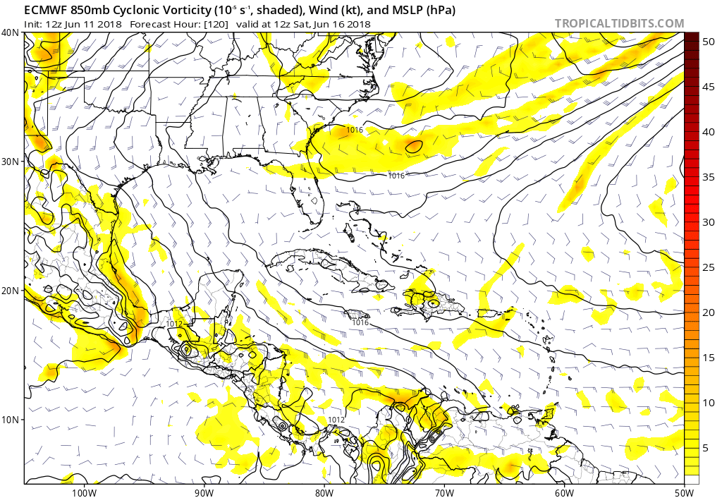
gatorcane

- S2K Supporter
- Posts: 23499
- Age: 46
- Joined: Sun Mar 13, 2005 3:54 pm
- Location: Boca Raton, FL
Re: Watching SW Caribbean: 2 PM TWO=10%-20%
Euro remains dead as a doornail, I would say. Also it seems to get buried in northern Mexico this time out through day 5, so while no rainfall map available on TT site, looks like less rain for Texas on this run:
0 likes

Re: Watching SW Caribbean: 2 PM TWO=10%-20%
Wednesday Morning at DMAX may be the best shot for genesis.

0 likes
Who is online
Users browsing this forum: Cleveland Kent Evans, cycloneye, Hurricaneman, ScottNAtlanta, zzzh and 48 guests