Disturbed Weather in NW Gulf/Texas
Moderator: S2k Moderators
Forum rules

The posts in this forum are NOT official forecasts and should not be used as such. They are just the opinion of the poster and may or may not be backed by sound meteorological data. They are NOT endorsed by any professional institution or STORM2K. For official information, please refer to products from the National Hurricane Center and National Weather Service.
-
stormreader
Disturbed Weather in NW Gulf/Texas
Nice blow up of storms began last evening in NW Carib just east of the Yucatan. This area left in the wake of Invest 91L which moved through a couple of days ago. Shear seems to have relaxed quite a bit in the NW Carib.
Last edited by stormreader on Mon Jun 18, 2018 7:29 am, edited 2 times in total.
1 likes

Re: NW Carib Flare-Up
I just noticed that as well and it looks like Texas will get a double dose of rain out of this.
1 likes
-
Weather150
- Tropical Storm

- Posts: 190
- Joined: Fri Jul 07, 2017 7:46 pm
Re: NW Carib Flare-Up
Just more rain for Texas, I don't see any sort of development out of this. Yes, shear is low, but no model support at all.
0 likes
-
wxman57

- Moderator-Pro Met

- Posts: 23172
- Age: 68
- Joined: Sat Jun 21, 2003 8:06 pm
- Location: Houston, TX (southwest)
Re: NW Carib Flare-Up
Weather150 wrote:Just more rain for Texas, I don't see any sort of development out of this. Yes, shear is low, but no model support at all.
It's another fast-moving tropical wave that we've been tracking for days. No development potential, just more moisture heading for the NW Gulf.
3 likes


Re: NW Carib Flare-Up
This vorticity will merge with the vorticity that composed 91L. You can see it come over the Yucatán at 850mb on the GFS; it’s the lobe on the northeast side of the mess that makes its way to Texas.
1 likes
-
wxman22

- Category 5

- Posts: 1920
- Joined: Mon Jan 30, 2006 12:39 am
- Location: Wichita Falls, TX
- Contact:
Re: NW Carib Flare-Up
The Canadian tries to close off the system tomorrow, and shows the system making landfall on the upper Texas coast maybe as a depression late Sunday night into Monday morning fwiw, not that I believe it... lol but I wouldn't be surprised if the system tried to spin up at the last minute but it would probably not have enough time to develop before moving inland, becoming essentially a "No Name" storm.


1 likes
-
jaguars_22
- Category 2

- Posts: 629
- Joined: Tue Jun 20, 2017 2:26 pm
- Location: Victoria TX
Re: NW Carib Flare-Up
Ya something is weird about the models... GFS shows moderate rainfall. Euro shows alot, icon shows monsoon, Some show closed low some dont... But this thing over the yucatan is looking healthy
Is there a radar out of cozumel
Is there a radar out of cozumel
0 likes


Re: NW Carib Flare-Up
jaguars_22 wrote:Ya something is weird about the models... GFS shows moderate rainfall. Euro shows alot, icon shows monsoon, Some show closed low some dont... But this thing over the yucatan is looking healthy
Is there a radar out of cozumel
ICON seems to think the conditions for former 91L get better after landfall. Perhaps we move into a better phase of the MJO (Phase 2) or maybe the atmosphere is just juiced in a few days for it to do what it's doing. I'm not necessarily buying it since it's the only model that maintains the low pressure over South Texas for as long as it does. I'm not discounting it completely either, but it seems anomalous. It also could be confusing the evolution of the secondary (NW Caribbean) low or possibly expecting some of that energy to transfer to near wherever 91L goes inland. Definitely a weird run.
0 likes
-
stormreader
Re: NW Carib Flare-Up
Siker wrote:This vorticity will merge with the vorticity that composed 91L. You can see it come over the Yucatán at 850mb on the GFS; it’s the lobe on the northeast side of the mess that makes its way to Texas.
I never understood that it was actually two distinct features. That’s why I was surprised to see the secondary flare-up off the Yucatan. So rainfall totals from models actually include precip from this secondary wave. Saw on other thread that CMC hints at closing it off along the upper Texas coast. Also that Houston station posted graphic saying they are monitoring it for formation.
0 likes
-
jaguars_22
- Category 2
- Posts: 629
- Joined: Tue Jun 20, 2017 2:26 pm
- Location: Victoria TX
Re: NW Carib Flare-Up
Seeing another deep blowup right where the "center" could be in this system... Im not a meteorologist but i did stay at a holiday inn...
1 likes
-
stormreader
Re: NW Carib Flare-Up
To the naked eye, it really looks like a lot of moisture associated with this “secondary system” just off the Yucatan. This has to be what models are mainly picking up on as far as rainfall totals. Wonder if projected totals are on the conservative side. Also, on visible, almost looks like beginnings of a mid level circulation just east of the Yucatan coast. At least that’s what it looks like to me.
0 likes
-
CyclonicFury

- Category 5
- Posts: 2032
- Age: 27
- Joined: Sun Jul 02, 2017 12:32 pm
- Location: NC
- Contact:
Re: NW Carib Flare-Up
2 likes
NCSU B.S. in Meteorology Class of 2021. Tropical weather blogger at http://www.cyclonicfury.com. My forecasts and thoughts are NOT official, for official forecasts please consult the National Hurricane Center.

Re: NW Carib Flare-Up
stormreader wrote:To the naked eye, it really looks like a lot of moisture associated with this “secondary system” just off the Yucatan. This has to be what models are mainly picking up on as far as rainfall totals. Wonder if projected totals are on the conservative side. Also, on visible, almost looks like beginnings of a mid level circulation just east of the Yucatan coast. At least that’s what it looks like to me.
That's what we said about 91L, same exact location.
0 likes
-
CyclonicFury
- Category 5
- Posts: 2032
- Age: 27
- Joined: Sun Jul 02, 2017 12:32 pm
- Location: NC
- Contact:
Re: NW Carib Flare-Up
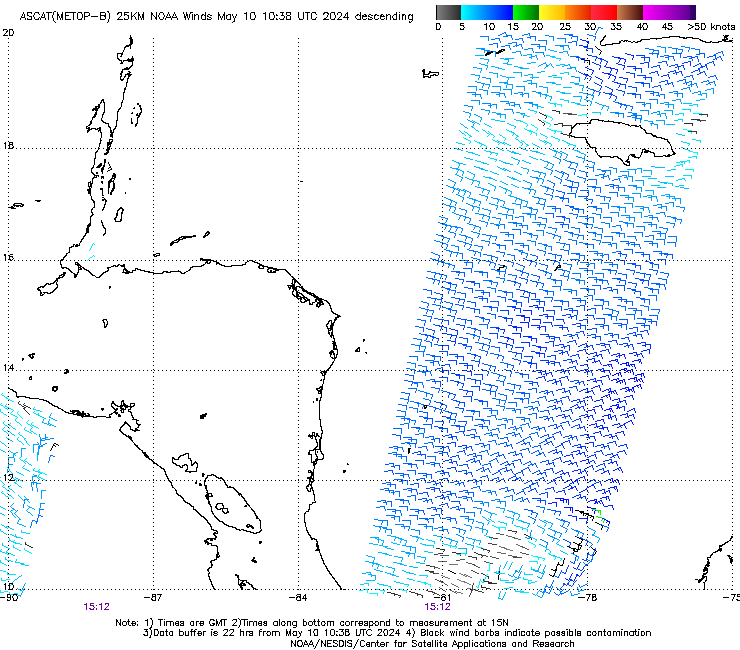
ASCAT shows some wind barbs of 30kts. Appears to be just a wave for now.
0 likes
NCSU B.S. in Meteorology Class of 2021. Tropical weather blogger at http://www.cyclonicfury.com. My forecasts and thoughts are NOT official, for official forecasts please consult the National Hurricane Center.
-
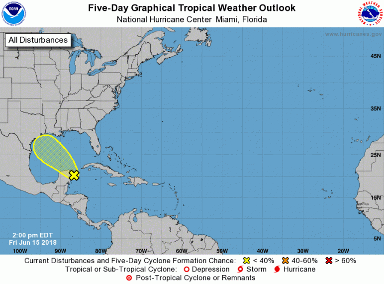
CyclonicFury
- Category 5
- Posts: 2032
- Age: 27
- Joined: Sun Jul 02, 2017 12:32 pm
- Location: NC
- Contact:
Re: NW Carib Flare-Up
2PM TWO 10/10
000
ABNT20 KNHC 151718
TWOAT
Tropical Weather Outlook
NWS National Hurricane Center Miami FL
200 PM EDT Fri Jun 15 2018
For the North Atlantic...Caribbean Sea and the Gulf of Mexico:
A large area of disorganized showers and thunderstorms over the
northwestern Caribbean Sea and the Yucatan Peninsula is associated
with a surface trough. While significant development of this system
is not anticipated, heavy rain and strong gusty winds are occurring
across the Yucatan Peninsula today, and will overspread the central
Gulf of Mexico on Saturday and reach portions of the Texas and
southwestern Louisiana coasts by Sunday. For more details on this
system please see products issued by your local weather office and
High Seas Forecasts issued by the National Weather Service.
* Formation chance through 48 hours...low...10 percent.
* Formation chance through 5 days...low...10 percent.
&&
High Seas Forecasts issued by the National Weather Service can be
found under AWIPS header NFDHSFAT1, WMO header FZNT01 KWBC, and
on the Web at http://ocean.weather.gov/shtml/NFDHSFAT1.shtml.
$$
Forecaster Blake
1 likes
NCSU B.S. in Meteorology Class of 2021. Tropical weather blogger at http://www.cyclonicfury.com. My forecasts and thoughts are NOT official, for official forecasts please consult the National Hurricane Center.
-
Weather150
- Tropical Storm
- Posts: 190
- Joined: Fri Jul 07, 2017 7:46 pm
-
Weather150
- Tropical Storm
- Posts: 190
- Joined: Fri Jul 07, 2017 7:46 pm
-
jaguars_22
- Category 2
- Posts: 629
- Joined: Tue Jun 20, 2017 2:26 pm
- Location: Victoria TX
Re: NW Carib Flare-Up
I thought that high pressure to the east was pushing everything west? How could it hit Louisiana? That path has it going right into houston
0 likes
-
stormreader
Re: NW Carib Flare-Up
jaguars_22 wrote:I thought that high pressure to the east was pushing everything west? How could it hit Louisiana? That path has it going right into houston
Well, there have been several model runs over the past few days which showed precipitation further north toward the upper Texas coast, and some even included heavy precip in extreme SW La (Lake Charles area). Others focused the precip toward south-central Texas. With system moving in over Corpus and heavy rains later over San Antonio. Will see how it plays out, but this "secondary system" seems to be oriented a little further north, so that the rain may be concentrated along the upper Texas coast and even put La in to play. Also, we could very well get a depression, and I wouldn't rule out a tropical storm from this. This has some model support from what I have read here (CMC).
2 likes
-
HurricaneA
- Tropical Low

- Posts: 12
- Age: 26
- Joined: Sat Jun 04, 2016 5:52 pm
- Location: Bryan, TX
Re: NW Carib Flare-Up
jaguars_22 wrote:I thought that high pressure to the east was pushing everything west? How could it hit Louisiana? That path has it going right into houston
The center would move into Texas, but Louisiana would still get rain from it.
0 likes
Who is online
Users browsing this forum: AnnularCane, Sciencerocks and 50 guests