Disturbed Weather in NW Gulf/Texas

This is the general tropical discussion area. Anyone can take their shot at predicting a storms path.

Moderator: S2k Moderators

Forum rules

The posts in this forum are NOT official forecasts and should not be used as such. They are just the opinion of the poster and may or may not be backed by sound meteorological data. They are NOT endorsed by any professional institution or STORM2K. For official information, please refer to products from the National Hurricane Center and National Weather Service.

Help Support Storm2K
Message
Author
User avatar
Clearcloudz
Category 2
Category 2
Posts: 523
Joined: Sun Jun 10, 2018 1:46 pm
Location: Rosenberg TX

Re: Disturbed Weather in Gulf

#141 Postby Clearcloudz » Sat Jun 16, 2018 1:52 pm

TheStormExpert wrote:What the Euro shows doesn’t even look like the 20/20% area. Once again it’s probably the remnants of Carlotta.


NHC leans very heavily on the EURO. Is that why there is only 20 percent instead of a higher percentage since all of the other models are still showing something.
0 likes   

User avatar
MGC
S2K Supporter
S2K Supporter
Posts: 5792
Joined: Sun Mar 23, 2003 9:05 pm
Location: Pass Christian MS, or what is left.

Re: Disturbed Weather in Gulf

#142 Postby MGC » Sat Jun 16, 2018 1:55 pm

So now the Euro is showing a closed low and the GFS isn't? This is looking like the year of the phantom model storm. We shall see, but looks like a very wet couple of days for Texas.....MGC
0 likes   

User avatar
Clearcloudz
Category 2
Category 2
Posts: 523
Joined: Sun Jun 10, 2018 1:46 pm
Location: Rosenberg TX

Re: Disturbed Weather in Gulf

#143 Postby Clearcloudz » Sat Jun 16, 2018 1:58 pm

Its very confusing on how the EURO strengthens the system a little over land.

Image

Image
0 likes   

Cpv17
Category 5
Category 5
Posts: 4319
Joined: Wed Dec 07, 2016 2:24 pm
Location: Wharton/El Campo, TX

Re: Disturbed Weather in Gulf

#144 Postby Cpv17 » Sat Jun 16, 2018 2:02 pm

That’s exactly what I said lol and that’s why I’m not believing it and also not believing that path it would take either. I’ve never seen a storm take that path, ever.
2 likes   

stormreader
Category 5
Category 5
Posts: 1242
Joined: Fri Jun 24, 2011 10:58 am

Re: Disturbed Weather in Gulf

#145 Postby stormreader » Sat Jun 16, 2018 2:10 pm

Sometimes in Oct gulf systems can take a south course for a time, never seen it in June. Almost like it’s showing a small surface vort which is being shunted around a larger mid level circulation. Your guess is as good (or better) than mine.
1 likes   

Cpv17
Category 5
Category 5
Posts: 4319
Joined: Wed Dec 07, 2016 2:24 pm
Location: Wharton/El Campo, TX

Re: Disturbed Weather in Gulf

#146 Postby Cpv17 » Sat Jun 16, 2018 2:12 pm

Crazy CMC makes the most sense to me as of now :eek: :lol:
2 likes   

stormlover2013
Category 5
Category 5
Posts: 2312
Joined: Thu Aug 22, 2013 12:06 pm
Location: Lumberton, Texas

Re: Disturbed Weather in Gulf

#147 Postby stormlover2013 » Sat Jun 16, 2018 2:15 pm

I mean I have never bet against the euro but who knows what will happen
0 likes   

User avatar
Rgv20
S2K Supporter
S2K Supporter
Posts: 2456
Age: 37
Joined: Wed Jan 05, 2011 5:42 pm
Location: Edinburg/McAllen Tx

Re: Disturbed Weather in Gulf

#148 Postby Rgv20 » Sat Jun 16, 2018 2:16 pm

The Euro is showing a trough of low pressure that hangs behind and stalls it in the Western Gulf. 12zWPC has a low pressure area attach to the trough by Day 4.

Image
1 likes   
The following post is NOT an official forecast and should not be used as such. It is just the opinion of the poster and may or may not be backed by sound meteorological data. It is NOT endorsed by any professional institution including storm2k.org For Official Information please refer to the NHC and NWS products.

Ntxw
Storm2k Moderator
Storm2k Moderator
Posts: 21501
Joined: Wed Oct 21, 2009 6:34 pm
Location: DFW, Texas

Re: Disturbed Weather in Gulf

#149 Postby Ntxw » Sat Jun 16, 2018 2:22 pm

ForexTidbits wrote:Its very confusing on how the EURO strengthens the system a little over land.


It's not all that confusing in my opinion. Systems that are not all tropical can do that. One of the Euro biases is that it likes to hang troughs in a westward/stalled movement over the progressive GFS. You have a lot of troughiness in the north, ridge to the northeast and lower pressures coming from the BOC and Carlotta.
2 likes   
The above post and any post by Ntxw is NOT an official forecast and should not be used as such. It is just the opinion of the poster and may or may not be backed by sound meteorological data. It is NOT endorsed by any professional institution including Storm2k. For official information, please refer to NWS products.

  Help support Storm2K!
Help Support Storm2K

User avatar
Clearcloudz
Category 2
Category 2
Posts: 523
Joined: Sun Jun 10, 2018 1:46 pm
Location: Rosenberg TX

Re: Disturbed Weather in Gulf

#150 Postby Clearcloudz » Sat Jun 16, 2018 2:26 pm

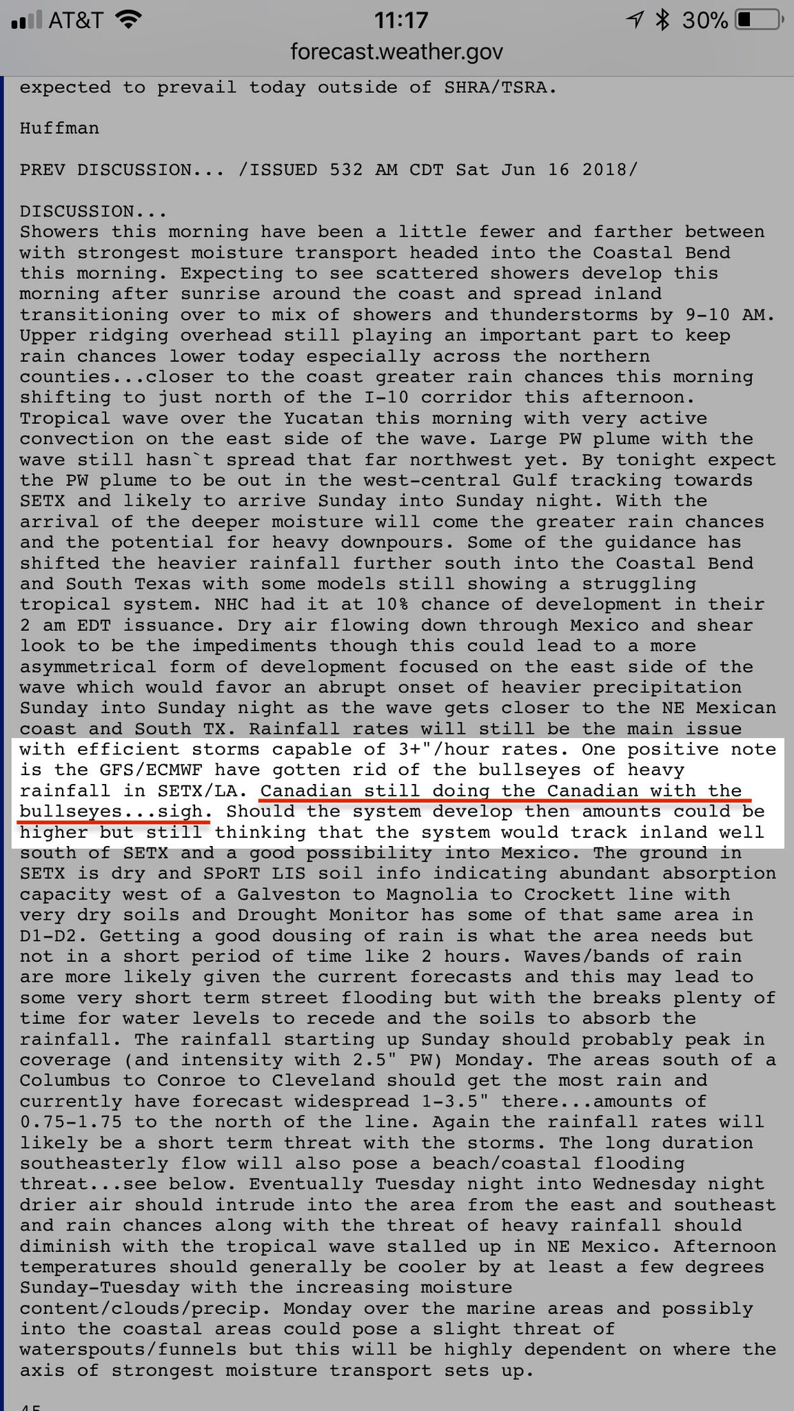
Cpv17 wrote:Crazy CMC makes the most sense to me as of now :eek: :lol:


NWS doesn't buy it

Image
0 likes   

User avatar
Clearcloudz
Category 2
Category 2
Posts: 523
Joined: Sun Jun 10, 2018 1:46 pm
Location: Rosenberg TX

Re: Disturbed Weather in Gulf

#151 Postby Clearcloudz » Sat Jun 16, 2018 2:31 pm

Ntxw wrote:
ForexTidbits wrote:Its very confusing on how the EURO strengthens the system a little over land.


It's not all that confusing in my opinion. Systems that are not all tropical can do that. One of the Euro biases is that it likes to hang troughs in a westward/stalled movement over the progressive GFS. You have a lot of troughiness in the north, ridge to the northeast and lower pressures coming from the BOC and Carlotta.


Makes sense. Thanks
0 likes   

User avatar
Rgv20
S2K Supporter
S2K Supporter
Posts: 2456
Age: 37
Joined: Wed Jan 05, 2011 5:42 pm
Location: Edinburg/McAllen Tx

Re: Disturbed Weather in Gulf

#152 Postby Rgv20 » Sat Jun 16, 2018 3:00 pm

12zECMWF Ensembles have come in more aggressive with Rainfall Totals and the chances for a potential tropical low pressure area for the Western GOM just offshore of NE Mexico/South Texas in the Tuesday thru Thursday time frame.
1 likes   
The following post is NOT an official forecast and should not be used as such. It is just the opinion of the poster and may or may not be backed by sound meteorological data. It is NOT endorsed by any professional institution including storm2k.org For Official Information please refer to the NHC and NWS products.

User avatar
Haris
Category 5
Category 5
Posts: 1808
Joined: Mon Nov 27, 2017 8:19 pm
Location: ( Bee Cave) West Austin, Texas

Re: Disturbed Weather in Gulf

#153 Postby Haris » Sat Jun 16, 2018 3:04 pm

Image

Don’t match euro ...

Trended wetter instead for Central and SE tX
1 likes   
Weather geek and a storm spotter in West Austin. Not a degreed meteorologist. Big snow fan. Love rain and cold! Despise heat!

User avatar
CyclonicFury
Category 5
Category 5
Posts: 1975
Age: 25
Joined: Sun Jul 02, 2017 12:32 pm
Location: NC
Contact:

Re: Disturbed Weather in Gulf

#154 Postby CyclonicFury » Sat Jun 16, 2018 3:20 pm

12z EPS at about a ~50% chance of development
[i mg]http://www.atmos.albany.edu/student/abrammer/graphics/ecmf_tc_data/plots/genesis/ecmf_gen_atl_2018061612.png[/img]
1 likes   
NCSU B.S. in Meteorology Class of 2021. Tropical weather blogger at http://www.cyclonicfury.com. My forecasts and thoughts are NOT official, for official forecasts please consult the National Hurricane Center.

stormreader
Category 5
Category 5
Posts: 1242
Joined: Fri Jun 24, 2011 10:58 am

Re: Disturbed Weather in Gulf

#155 Postby stormreader » Sat Jun 16, 2018 3:31 pm

Rgv20 wrote:The Euro is showing a trough of low pressure that hangs behind and stalls it in the Western Gulf. 12zWPC has a low pressure area attach to the trough by Day 4.

http://i64.tinypic.com/skyi4g.gif

Looks like the disturbance is being pretty much stretched out and absorbed into the diving trough in the western gulf. The upper level flow with the trough is north to south along the Texas coast. Guess any smaller scale surface feature that would develop close to the Texas coast would still be caught within the trough, and at least in the short term moved with the flow from north to south along the coast. At least that’s what the model shows now.
0 likes   

tolakram
Admin
Admin
Posts: 19165
Age: 60
Joined: Sun Aug 27, 2006 8:23 pm
Location: Florence, KY (name is Mark)

Re: Disturbed Weather in Gulf

#156 Postby tolakram » Sat Jun 16, 2018 3:43 pm

REMINDER :)

Do not wrap IMG tags around links to model sites. If you want to post an image then upload it to an image site like imgur or tinypic first.

Thanks.
1 likes   
M a r k
- - - - -
Join us in chat: Storm2K Chatroom Invite. Android and IOS apps also available.

The posts in this forum are NOT official forecasts and should not be used as such. Posts are NOT endorsed by any professional institution or STORM2K.org. For official information and forecasts, please refer to NHC and NWS products.

User avatar
Steve
S2K Supporter
S2K Supporter
Posts: 8606
Joined: Sat Apr 05, 2003 11:41 pm
Location: Not a state-caster

Re: Disturbed Weather in Gulf

#157 Postby Steve » Sat Jun 16, 2018 3:51 pm

Ntxw wrote:
ForexTidbits wrote:Its very confusing on how the EURO strengthens the system a little over land.


It's not all that confusing in my opinion. Systems that are not all tropical can do that. One of the Euro biases is that it likes to hang troughs in a westward/stalled movement over the progressive GFS. You have a lot of troughiness in the north, ridge to the northeast and lower pressures coming from the BOC and Carlotta.


Joe B has it sort of what Alyono said yesterday. The current system moves toward TX and leaves behind a weakness where the next wave coming up intersects leaving big weather potential (many inches to possibly a couple feet of rain) for Deep South Texas and the RGV and certainly the states of Tamaulipas and Nuevo León.

I don’t know if some of the moisture or energy from Carlotta comes up or not. But 91L I think was the leading edge of a deep tropical stream moving toward the Western and Southwestern Gulf. MIMIC shows it well. It is an interesting pattern to watch evolve.
Last edited by Steve on Sat Jun 16, 2018 3:57 pm, edited 1 time in total.
1 likes   

User avatar
Rgv20
S2K Supporter
S2K Supporter
Posts: 2456
Age: 37
Joined: Wed Jan 05, 2011 5:42 pm
Location: Edinburg/McAllen Tx

Re: Disturbed Weather in Gulf

#158 Postby Rgv20 » Sat Jun 16, 2018 3:57 pm

A nice detailed discussion this afternoon from the NWS in Brownsville.

.LONG TERM (Monday through Saturday): In the grand scheme of
things, confidence is high that much of the Rio Grande Valley and
Deep S. Texas is going to get wet, and the current moderate to
severe drought that covers the Lower Valley and King Ranch will be
dented to some degree in for the drought monitor that will be
issued in ten days. The big question remains: How much rain, and
exactly where? The primary models we consider...US GFS and
ECMWF...are in similar camps with the big picture but differ
notably in the details during the key rain period. That key period
remains late Monday night through Wednesday and has been
consistent for a few days so confidence is high on this timing.

What is not so confident is how much rain we actually get. After
coordinating with WPC and liking the more run-to-run consistent
GFS the expectation is for the heaviest rainfall to be in the
coastal counties during the period, tailing off gradually for the
mid Valley through Brooks County with lesser rains across the Rio
Grande Plains and Upper Valley. For now, a lower bound of total
rainfall is in the 2 to 4 inch range east half and 1 to 2 inch
rain west half...all great news for the aforementioned drought
conditions. However...the upper bound? We don`t know just yet. If
deterministic ECMWF were to verify spot on, we`re talking much
more rainfall than described...but a shift of the upper system
farther south or north would change the totals dramatically
downward. Bottom line? We`ll be looking much more closely this
time tomorrow as the start of the "big" rains will be within the
48 hour time frame...and based on most likely and reasonable
worse-case scenarios we`ll hope to have a better idea of the
potential range of rainfall and impacts. Obviously, a situation
more akin to the ECMWF...whose dynamics combined with deep
tropical moisture are quite impressive...would become a more
serious concern for widespread flooding and height of water depth
in poor drainage locations.

After Wednesday the general trend is for lesser rain but still
enough moisture and forcing to keep some mention in the forecast.
Due to spending most time assessing the Monday-Wednesday time
frame made little change to the end of week forecast but will
address Thursday more closely this time tomorrow.

For the sensible weather, then: Monday will see more clouds and
showers, with some embedded thunder. Latest GFS brought the curl
of vorticity over the eastern part of the area and with a bit more
mid level southeast flow confidence is higher in some
rain...though prefer to see deeper moisture and less easterly flow
in the rain-production area than currently shown. For this reason,
have kept rain chances in the likely category but nothing higher.
QPF is up and local downpours could produce an inch or two.

Late Monday night through Midday Tuesday sees deepening southeast
flow and full saturation of the column with precipitable water
values up over 2.5 inches (GFS, similar or higher on the ECMWF)
and the correct position of the upper level features. In the past,
this setup brings the heaviest persistent rainfall between late
night and early afternoon, spreading from coast to inland but
fading a bit approaching the upper Valley and Rio Grande Plains.
Likely to be a late afternoon through midnight `lull` with
atmosphere worked over before things recycle again Tuesday night
into Wednesday with similar results. With the widespread rain and
cloud cover have lowered temperatures into the upper 80s which
could be a few degrees too generous at this point...and will
adjust accordingly in next few days. Note that the ECMWF, should
its solution be closer to reality, would include less of a lull if
at all.

With lowering rain chances (potentially...this is still
uncertain) Wednesday night and beyond have raised daytime
temperatures to close the week...with Thursday an uncertain lower
90s for most areas and back to the lower to mid 90s to close the
week. These lower temperatures will also be influenced by the
amount of water absorbed or still on the ground, as well.

Bottom line? Now is the time to prepare for potential flooding;
tips are on today`s daily briefing at
http://weather.gov/rgv/briefing or on our social media pages.

&&
1 likes   
The following post is NOT an official forecast and should not be used as such. It is just the opinion of the poster and may or may not be backed by sound meteorological data. It is NOT endorsed by any professional institution including storm2k.org For Official Information please refer to the NHC and NWS products.

stormlover2013
Category 5
Category 5
Posts: 2312
Joined: Thu Aug 22, 2013 12:06 pm
Location: Lumberton, Texas

Re: Disturbed Weather in Gulf

#159 Postby stormlover2013 » Sat Jun 16, 2018 4:23 pm

ICOn model sticks to its guns
0 likes   

EasyTiger
Tropical Depression
Tropical Depression
Posts: 54
Joined: Wed Jul 27, 2011 8:42 am
Location: Houston, TX

Re: Disturbed Weather in Gulf

#160 Postby EasyTiger » Sat Jun 16, 2018 4:26 pm

stormlover2013 wrote:ICOn model sticks to its guns


Saw that. How reliable is the ICON for tropical systems?
0 likes   


Return to “Talkin' Tropics”

Who is online

Users browsing this forum: Bing [Bot], cycloneye and 196 guests