Isn't the AMO negative despite the warm anomaly in the subtropics?
https://www.ncbi.nlm.nih.gov/pmc/articles/PMC5593924/
2018 Indicators: SST's / MSLP / Sal / Steering / Shear / Instability (Graphic updates at first post)
Moderator: S2k Moderators
Forum rules

The posts in this forum are NOT official forecasts and should not be used as such. They are just the opinion of the poster and may or may not be backed by sound meteorological data. They are NOT endorsed by any professional institution or STORM2K. For official information, please refer to products from the National Hurricane Center and National Weather Service.

Re: 2018 Indicators: SST's / MSLP / Sal / Steering / Shear / Instability (Graphic updates at first post)
Visioen wrote:Isn't the AMO negative despite the warm anomaly in the subtropics?
https://www.ncbi.nlm.nih.gov/pmc/articles/PMC5593924/
The warm subtropics and cold tropics in part is what the -AMO is, at least spatial SSTa
+AMO is inverse, generally speaking when looking at SSTa reflection to the MSLP pattern, cooler subtropics and warmer tropics over the Atlantic.
3 likes
The above post and any post by Ntxw is NOT an official forecast and should not be used as such. It is just the opinion of the poster and may or may not be backed by sound meteorological data. It is NOT endorsed by any professional institution including Storm2k. For official information, please refer to NWS products.
Help support Storm2K!
-
gatorcane

- S2K Supporter

- Posts: 23499
- Age: 46
- Joined: Sun Mar 13, 2005 3:54 pm
- Location: Boca Raton, FL
Re: 2018 Indicators: SST's / MSLP / Sal / Steering / Shear / Instability (Graphic updates at first post)
Waves over Africa look quite impressive again early season with cyclonic spin evident on the three main waves in this loop. Click link below and speed up loop. One is exiting the coast to tonight, another is over Central Africa, and another is over Far Eastern Africa. Conditions too hostile now for development in MDR (as expected) but these vigorous waves may be an indicator we will see some decent Cape Verde activity again this year come August and September when conditions should improve:
http://rammb.cira.colostate.edu/ramsdis ... display=24
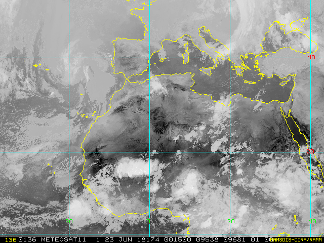
http://rammb.cira.colostate.edu/ramsdis ... display=24
5 likes
-
OuterBanker
- S2K Supporter
- Posts: 1704
- Joined: Wed Feb 26, 2003 10:53 am
- Location: Nags Head, NC
- Contact:
Re: 2018 Indicators: SST's / MSLP / Sal / Steering / Shear / Instability (Graphic updates at first post)
I guess the bottom line is that I don't ever remember water temps being this warm at this time of the year. I don't know the statistics but I imagine it will pose an increased threat in the subtropical region. Specifically the Carolinas and North. Furthermore, it will also allow storms to either maintain their strength or even increase in intensity. That is my major concern.
1 likes

Re: 2018 Indicators: SST's / MSLP / Sal / Steering / Shear / Instability (Graphic updates at first post)
Call me a skeptic, but I think the season will be active precisely because of a robust wave train that may remain present during this season. I keep seeing this in the CFS during August & September. What worries me as the season reaches the peak is it looks like conditions get more favorable for these waves closer to the islands like last year.
Of course the rapid onset of the El Niño could negate this in future runs. Let see how it continues to play out.
CFS
http://www.weatheronline.co.uk/cgi-bin/expertcharts?LANG=en&MENU=0000000000&CONT=noat&MODELL=cfs&MODELLTYP=1&BASE=-&VAR=pslv&HH=396&ARCHIV=0&ZOOM=0&PERIOD=&WMO=
Of course the rapid onset of the El Niño could negate this in future runs. Let see how it continues to play out.
CFS
http://www.weatheronline.co.uk/cgi-bin/expertcharts?LANG=en&MENU=0000000000&CONT=noat&MODELL=cfs&MODELLTYP=1&BASE=-&VAR=pslv&HH=396&ARCHIV=0&ZOOM=0&PERIOD=&WMO=
1 likes
The following post is NOT an official forecast and should not be used as such. It is just the opinion of the poster and may or may not be backed by sound meteorological data. It is NOT endorsed by any professional institution including storm2k.org For Official Information please refer to the NHC and NWS products.
-
AutoPenalti
- Category 5

- Posts: 3949
- Age: 27
- Joined: Mon Aug 17, 2015 4:16 pm
- Location: Ft. Lauderdale, Florida
Re: 2018 Indicators: SST's / MSLP / Sal / Steering / Shear / Instability (Graphic updates at first post)
gatorcane wrote:Waves over Africa look quite impressive again early season with cyclonic spin evident on the three main waves in this loop. Click link below and speed up loop. One is exiting the coast to tonight, another is over Central Africa, and another is over Far Eastern Africa. Conditions too hostile now for development in MDR (as expected) but these vigorous waves may be an indicator we will see some decent Cape Verde activity again this year come August and September when conditions should improve:
http://rammb.cira.colostate.edu/ramsdis ... display=24
Correct me if I’m wrong but is this not an indicator of a passing MJO?
0 likes
The posts in this forum are NOT official forecasts and should not be used as such. They are just the opinion of the poster and may or may not be backed by sound meteorological data. They are NOT endorsed by any professional institution or STORM2K. For official information, please refer to products from the NHC and NWS.
Model Runs Cheat Sheet:
GFS (5:30 AM/PM, 11:30 AM/PM)
HWRF, GFDL, UKMET, NAVGEM (6:30-8:00 AM/PM, 12:30-2:00 AM/PM)
ECMWF (1:45 AM/PM)
TCVN is a weighted averaged
-
Yellow Evan

- Professional-Met

- Posts: 15951
- Age: 25
- Joined: Fri Jul 15, 2011 12:48 pm
- Location: Henderson, Nevada/Honolulu, HI
- Contact:
Re: 2018 Indicators: SST's / MSLP / Sal / Steering / Shear / Instability (Graphic updates at first post)
blp wrote:Call me a skeptic, but I think the season will be active precisely because of a robust wave train that may remain present during this season. I keep seeing this in the CFS during August & September. What worries me as the season reaches the peak is it looks like conditions get more favorable for these waves closer to the islands like last year.
Of course the rapid onset of the El Niño could negate this in future runs. Let see how it continues to play out.
CFS
http://www.weatheronline.co.uk/cgi-bin/expertcharts?LANG=en&MENU=0000000000&CONT=noat&MODELL=cfs&MODELLTYP=1&BASE=-&VAR=pslv&HH=396&ARCHIV=0&ZOOM=0&PERIOD=&WMO=
A robust wave train means very little when conditions in the MDR are not favorable with the present SST configuration. The long range CFS regularly showed sufficient activity months in advance even during the inactive period from 2013-2015, so I don't think that means much.
3 likes
Re: 2018 Indicators: SST's / MSLP / Sal / Steering / Shear / Instability (Graphic updates at first post)
Yellow Evan wrote:blp wrote:Call me a skeptic, but I think the season will be active precisely because of a robust wave train that may remain present during this season. I keep seeing this in the CFS during August & September. What worries me as the season reaches the peak is it looks like conditions get more favorable for these waves closer to the islands like last year.
Of course the rapid onset of the El Niño could negate this in future runs. Let see how it continues to play out.
CFS
http://www.weatheronline.co.uk/cgi-bin/expertcharts?LANG=en&MENU=0000000000&CONT=noat&MODELL=cfs&MODELLTYP=1&BASE=-&VAR=pslv&HH=396&ARCHIV=0&ZOOM=0&PERIOD=&WMO=
A robust wave train means very little when conditions in the MDR are not favorable with the present SST configuration. The long range CFS regularly showed sufficient activity months in advance even during the inactive period from 2013-2015, so I don't think that means much.
I saw it differently the CFS was showing things pretty dead in those years which is why I made my point. I agree the CFS ain't the best but it's not that bad to look at patterns.
1 likes
The following post is NOT an official forecast and should not be used as such. It is just the opinion of the poster and may or may not be backed by sound meteorological data. It is NOT endorsed by any professional institution including storm2k.org For Official Information please refer to the NHC and NWS products.
-
cycloneye

- Admin

- Posts: 139052
- Age: 67
- Joined: Thu Oct 10, 2002 10:54 am
- Location: San Juan, Puerto Rico
Re: 2018 Indicators: SST's / MSLP / Sal / Steering / Shear / Instability (Graphic updates at first post)
2 likes
Visit the Caribbean-Central America Weather Thread where you can find at first post web cams,radars
and observations from Caribbean basin members Click Here
and observations from Caribbean basin members Click Here
-
gatorcane
- S2K Supporter
- Posts: 23499
- Age: 46
- Joined: Sun Mar 13, 2005 3:54 pm
- Location: Boca Raton, FL
Re: 2018 Indicators: SST's / MSLP / Sal / Steering / Shear / Instability (Graphic updates at first post)
cycloneye wrote:Big sal outbreak right now.See loop at link.
http://tropic.ssec.wisc.edu/real-time/s ... E5new.html
Yes but expected this time of year. One thing I notice is that the wave train over Africa seems more north than usual when I loop the loop. But maybe this is normal too? I wonder if the effect might mean a bit less SAL than usual come the peak Cape Verde months as the region would be more moist than usual?
http://rammb.cira.colostate.edu/ramsdis ... display=24
Saved image:
0 likes
-
ScottNAtlanta

- Category 5
- Posts: 1998
- Joined: Sat May 25, 2013 3:11 pm
- Location: Atlanta, GA
Re: 2018 Indicators: SST's / MSLP / Sal / Steering / Shear / Instability (Graphic updates at first post)
cycloneye wrote:Big sal outbreak right now.See loop at link.
http://tropic.ssec.wisc.edu/real-time/s ... E5new.html
Thats pretty much to be expected this time of year and into July. Interesting in that it is confined to north of 20 degrees latitude.
0 likes
The posts in this forum are NOT official forecast and should not be used as such. They are just the opinion of the poster and may or may not be backed by sound meteorological data. They are NOT endorsed by any professional institution or storm2k.org. For official information, please refer to the NHC and NWS products.


Re: 2018 Indicators: SST's / MSLP / Sal / Steering / Shear / Instability (Graphic updates at first post)
gatorcane wrote:cycloneye wrote:Big sal outbreak right now.See loop at link.
http://tropic.ssec.wisc.edu/real-time/s ... E5new.html
Yes but expected this time of year. One thing I notice is that the wave train over Africa seems more north than usual when I loop the loop. But maybe this is normal too? I wonder if the effect might mean a bit less SAL than usual come the peak Cape Verde months as the region would be more moist than usual?
http://rammb.cira.colostate.edu/ramsdis ... display=24
Saved image:
They are further north than normal. I made a post here about a week ago with an image of the northern displacement of rainfall over Africa the past month and a half.
0 likes
-
TheStormExpert

- Category 5
- Posts: 8487
- Age: 30
- Joined: Wed Feb 16, 2011 5:38 pm
- Location: Palm Beach Gardens, FL
Re: 2018 Indicators: SST's / MSLP / Sal / Steering / Shear / Instability (Graphic updates at first post)
1 likes
The following post is NOT an official forecast and should not be used as such. It is just the opinion of the poster and may or may not be backed by sound meteorological data. It is NOT endorsed by storm2k.org.
-
TheStormExpert
- Category 5
- Posts: 8487
- Age: 30
- Joined: Wed Feb 16, 2011 5:38 pm
- Location: Palm Beach Gardens, FL
Re: 2018 Indicators: SST's / MSLP / Sal / Steering / Shear / Instability (Graphic updates at first post)
Too much weight may be getting put on the colder SST’s in the Tropical Atlantic.
https://twitter.com/bobbistorm/status/1011443043873026050
https://twitter.com/crownweather/status/1011443911456428032
https://twitter.com/bobbistorm/status/1011443043873026050
https://twitter.com/crownweather/status/1011443911456428032
2 likes
The following post is NOT an official forecast and should not be used as such. It is just the opinion of the poster and may or may not be backed by sound meteorological data. It is NOT endorsed by storm2k.org.
-
gatorcane
- S2K Supporter
- Posts: 23499
- Age: 46
- Joined: Sun Mar 13, 2005 3:54 pm
- Location: Boca Raton, FL
Re: 2018 Indicators: SST's / MSLP / Sal / Steering / Shear / Instability (Graphic updates at first post)
TheStormExpert wrote:Too much weight may be getting put on the colder SST’s in the Tropical Atlantic.
https://twitter.com/bobbistorm/status/1 ... 3873026050
https://twitter.com/crownweather/status ... 1456428032
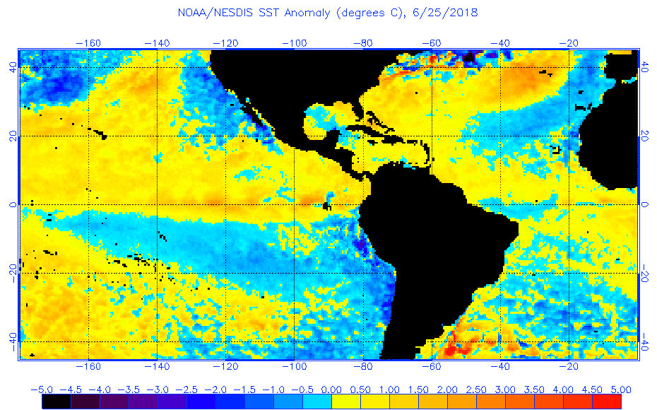
Yes agreed. Also notice how quickly the waters are warming around the Bahamas and Caribbean. Compare image from just 1 week ago:

1 likes
-
TheStormExpert
- Category 5
- Posts: 8487
- Age: 30
- Joined: Wed Feb 16, 2011 5:38 pm
- Location: Palm Beach Gardens, FL
Re: 2018 Indicators: SST's / MSLP / Sal / Steering / Shear / Instability (Graphic updates at first post)
gatorcane wrote:TheStormExpert wrote:Too much weight may be getting put on the colder SST’s in the Tropical Atlantic.
https://twitter.com/bobbistorm/status/1 ... 3873026050
https://twitter.com/crownweather/status ... 1456428032
Yes agreed. Also notice how quickly the waters are warming around the Bahamas and Caribbean. Compare image from just 1 week ago:
https://s22.postimg.cc/uo8pnj5sx/anomw.6.25.2018.gif
https://s22.postimg.cc/ks7mnk7n5/anomw.6.18.2018.gif
Also look at the huge SST gradient at around 50-55W. If these tropical waves can make it to that point and even head north of the Caribbean they’re chances of development drastically increase IMO. Also need to really watch the Gulf.

0 likes
The following post is NOT an official forecast and should not be used as such. It is just the opinion of the poster and may or may not be backed by sound meteorological data. It is NOT endorsed by storm2k.org.
-
tolakram
- Admin
- Posts: 19165
- Age: 60
- Joined: Sun Aug 27, 2006 8:23 pm
- Location: Florence, KY (name is Mark)
Re: 2018 Indicators: SST's / MSLP / Sal / Steering / Shear / Instability (Graphic updates at first post)
If there's one common theme to seasonal predictions it seems that too much weight is always placed on something. 
3 likes
M a r k
- - - - -
Join us in chat: Storm2K Chatroom Invite. Android and IOS apps also available.
The posts in this forum are NOT official forecasts and should not be used as such. Posts are NOT endorsed by any professional institution or STORM2K.org. For official information and forecasts, please refer to NHC and NWS products.
-
txwatcher91
- Category 5
- Posts: 1498
- Joined: Tue Aug 02, 2005 2:29 pm
Re: 2018 Indicators: SST's / MSLP / Sal / Steering / Shear / Instability (Graphic updates at first post)
IMO the warmer waters in the Western Atlantic are more concerning because this is where the chances for landfall significantly increase. Without a strong blocking high in place the Cape Verde storms have a pretty good chance of recurving harmlessly out to sea. With the cooler SST's in the East Atlantic this may just allow the waves to stay weaker and head west until they hit the warmer waters near the Caribbean. We also still have about 1.5-2 months for the water anomalies to change in time for the prime part of hurricane season as well.
1 likes
-
TheStormExpert
- Category 5
- Posts: 8487
- Age: 30
- Joined: Wed Feb 16, 2011 5:38 pm
- Location: Palm Beach Gardens, FL
Re: 2018 Indicators: SST's / MSLP / Sal / Steering / Shear / Instability (Graphic updates at first post)
txwatcher91 wrote:IMO the warmer waters in the Western Atlantic are more concerning because this is where the chances for landfall significantly increase. Without a strong blocking high in place the Cape Verde storms have a pretty good chance of recurving harmlessly out to sea. With the cooler SST's in the East Atlantic this may just allow the waves to stay weaker and head west until they hit the warmer waters near the Caribbean. We also still have about 1.5-2 months for the water anomalies to change in time for the prime part of hurricane season as well.
With chances increasing of an El Niño or El Niño-like conditions the Caribbean should be just as hostile if not more hostile than the Tropical Atlantic.
https://twitter.com/philklotzbach/status/1011747343933235200
2 likes
The following post is NOT an official forecast and should not be used as such. It is just the opinion of the poster and may or may not be backed by sound meteorological data. It is NOT endorsed by storm2k.org.
-
txwatcher91
- Category 5
- Posts: 1498
- Joined: Tue Aug 02, 2005 2:29 pm
Re: 2018 Indicators: SST's / MSLP / Sal / Steering / Shear / Instability (Graphic updates at first post)
TheStormExpert wrote:txwatcher91 wrote:IMO the warmer waters in the Western Atlantic are more concerning because this is where the chances for landfall significantly increase. Without a strong blocking high in place the Cape Verde storms have a pretty good chance of recurving harmlessly out to sea. With the cooler SST's in the East Atlantic this may just allow the waves to stay weaker and head west until they hit the warmer waters near the Caribbean. We also still have about 1.5-2 months for the water anomalies to change in time for the prime part of hurricane season as well.
With chances increasing of an El Niño or El Niño-like conditions the Caribbean should be just as hostile if not more hostile than the Tropical Atlantic.
Yes El Nino could definitely slow things down if the higher wind shear persists into the prime of hurricane season but right now that's still a big question mark as to how quickly it will evolve, how strong, if there will be any lag effect, etc. My main point is that cooler than normal SST's = less active is not always the case, it oftentimes can delay development and increase landfall chances for systems that do form. El Nino development and shear will be the primary driver for an active or slow season and we won't have a good idea on what that'll be like until we get closer and have systems rolling off Africa to monitor.
0 likes
Who is online
Users browsing this forum: aspen, Cat5James, KirbyDude25, Landy and 116 guests