Tropical Wave over the SE Bahamas (Is INVEST 91L)
Moderator: S2k Moderators
Forum rules

The posts in this forum are NOT official forecasts and should not be used as such. They are just the opinion of the poster and may or may not be backed by sound meteorological data. They are NOT endorsed by any professional institution or STORM2K. For official information, please refer to products from the National Hurricane Center and National Weather Service.
-
South Texas Storms

- Professional-Met

- Posts: 4005
- Joined: Thu Jun 24, 2010 12:28 am
- Location: Houston, TX
Re: Tropical Wave in the Turks & Caicos/SE Bahamas
0z Euro ensembles still has several members that take tropical storms south of Houston.
1 likes
-
Bayousaint
- Tropical Low

- Posts: 10
- Joined: Wed Sep 06, 2017 10:08 pm
Re: Tropical Wave in the Turks & Caicos/SE Bahamas
South Texas Storms wrote:0z Euro ensembles still has several members that take tropical storms south of Houston.
Is there a link or picture of this info I can look at?
1 likes
-
Clearcloudz

- Category 2

- Posts: 523
- Joined: Sun Jun 10, 2018 1:46 pm
- Location: Rosenberg TX
-
cycloneye

- Admin

- Posts: 139080
- Age: 67
- Joined: Thu Oct 10, 2002 10:54 am
- Location: San Juan, Puerto Rico
Re: Tropical Wave over the SE Bahamas
06z GFS more bullish.Has a Tropical Storm for Louisiana/Alabama.

0 likes
Visit the Caribbean-Central America Weather Thread where you can find at first post web cams,radars
and observations from Caribbean basin members Click Here
and observations from Caribbean basin members Click Here
-
Dylan

- Professional-Met
- Posts: 337
- Age: 29
- Joined: Mon May 31, 2010 9:50 am
- Location: New Orleans, LA
Re: Tropical Wave over the SE Bahamas
Between the 0Z EURO/UKMET/CMC and the 6Z GFS, you have fairly good consensus of a 35-45kt tropical storm into Louisiana on Wednesday morning.
0 likes
Georges('98), Allison('01), Isidore('02), Lili('02), Frances('04) Ivan('04), Cindy('05), Katrina('05), Rita('05), Gustav('08), Isaac('12), Matthew('16), Harvey('17), Irma('17), Nate ('17), Ida ('21).
Re: Tropical Wave over the SE Bahamas
What are the odds of this becoming a Hurricane with the high Sea Temps and not much disruption in the atmosphere and currents from other systems. Any chance of RI like Harvey last year?
0 likes
Personal Forecast Disclaimer:
The posts in this forum are NOT official forecast and should not be used as such. They are just the opinion of the poster and may or may not be backed by sound meteorological data. They are NOT endorsed by any professional institution or storm2k.org. For official information, please refer to the NHC and NWS products.
The posts in this forum are NOT official forecast and should not be used as such. They are just the opinion of the poster and may or may not be backed by sound meteorological data. They are NOT endorsed by any professional institution or storm2k.org. For official information, please refer to the NHC and NWS products.
-
tropicwatch

- Category 5

- Posts: 3205
- Age: 60
- Joined: Sat Jun 02, 2007 10:01 am
- Location: Panama City Florida
- Contact:
Re: Tropical Wave over the SE Bahamas
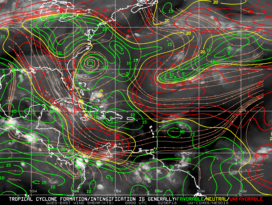
The wind shear has relaxed considerably this morning and there might be a start to some banding features.
0 likes
Tropicwatch
Agnes 72', Eloise 75, Elena 85', Kate 85', Charley 86', Florence 88', Beryl 94', Dean 95', Erin 95', Opal 95', Earl 98', Georges 98', Ivan 2004', Arlene 2005', Dennis 2005', Ida 2009' Debby 2012' Irma 2017' Michael 2018'
Agnes 72', Eloise 75, Elena 85', Kate 85', Charley 86', Florence 88', Beryl 94', Dean 95', Erin 95', Opal 95', Earl 98', Georges 98', Ivan 2004', Arlene 2005', Dennis 2005', Ida 2009' Debby 2012' Irma 2017' Michael 2018'
-
OuterBanker
- S2K Supporter

- Posts: 1704
- Joined: Wed Feb 26, 2003 10:53 am
- Location: Nags Head, NC
- Contact:
Re: Tropical Wave in the Turks & Caicos/SE Bahamas
ForexTidbits wrote:00Z ECMWF Ensemble members
https://weather.us/cyclone-tracks/euro/902-w-263-n/2018090200-240.html
Actually fairly tightly clustered. Looks like ts strength and a La strike. Looks like it will be a flooding concern. Of interest is the North turn after landfall in the GFS instead of along coast to Tx. Of concern though is Florence for the east coast. The forecast fish looks more like a threat in the 00z Euro.
3 likes

Re: Tropical Wave over the SE Bahamas
First visuals will be intresting, looks to be a bit more convection building right now.
0 likes
Personal Forecast Disclaimer:
The posts in this forum are NOT official forecast and should not be used as such. They are just the opinion of the poster and may or may not be backed by sound meteorological data. They are NOT endorsed by any professional institution or storm2k.org. For official information, please refer to the NHC and NWS products.
The posts in this forum are NOT official forecast and should not be used as such. They are just the opinion of the poster and may or may not be backed by sound meteorological data. They are NOT endorsed by any professional institution or storm2k.org. For official information, please refer to the NHC and NWS products.

Re: Tropical Wave over the SE Bahamas
Hard to tell from infrared but seems to still be a LLC near 22.2 -75.4 which should be partially exposed in a couple hours.
0 likes
-
tropicwatch
- Category 5
- Posts: 3205
- Age: 60
- Joined: Sat Jun 02, 2007 10:01 am
- Location: Panama City Florida
- Contact:
Re: Tropical Wave over the SE Bahamas
With time getting short, the NHC might have to go straight to PTC.
0 likes
Tropicwatch
Agnes 72', Eloise 75, Elena 85', Kate 85', Charley 86', Florence 88', Beryl 94', Dean 95', Erin 95', Opal 95', Earl 98', Georges 98', Ivan 2004', Arlene 2005', Dennis 2005', Ida 2009' Debby 2012' Irma 2017' Michael 2018'
Agnes 72', Eloise 75, Elena 85', Kate 85', Charley 86', Florence 88', Beryl 94', Dean 95', Erin 95', Opal 95', Earl 98', Georges 98', Ivan 2004', Arlene 2005', Dennis 2005', Ida 2009' Debby 2012' Irma 2017' Michael 2018'
-
cycloneye
- Admin
- Posts: 139080
- Age: 67
- Joined: Thu Oct 10, 2002 10:54 am
- Location: San Juan, Puerto Rico
Re: Tropical Wave over the SE Bahamas
8 AM TWO=50%/80%

Disorganized showers and thunderstorms over the southeastern and
central Bahamas and adjacent Atlantic waters, including the Straits
of Florida, are associated with a tropical wave interacting with an
upper-level trough. This weather system is expected to move
west-northwestward across the remainder of the Bahamas, southern
Florida, and the Florida Keys during the next day or so and little,
if any, development is expected during that time due to strong
upper-level winds. However, the current unfavorable upper-level
wind pattern is expected to gradually change and become more
conducive for a tropical depression to form over the eastern and
central Gulf of Mexico by Tuesday or Wednesday. This disturbance
will spread locally heavy rains across much of the Bahamas, southern
Florida, and the Keys during the next day or two. See products from
your local weather forecast office for more information.
* Formation chance through 48 hours...medium...50 percent.
* Formation chance through 5 days...high...80 percent.
0 likes
Visit the Caribbean-Central America Weather Thread where you can find at first post web cams,radars
and observations from Caribbean basin members Click Here
and observations from Caribbean basin members Click Here

Re: Tropical Wave over the SE Bahamas
2 likes
Re: Tropical Wave over the SE Bahamas
For those that have been asking here is the latest Euro's ensembles, which in the range of 80-90% of them show development.

2 likes
-
tolakram
- Admin
- Posts: 19165
- Age: 60
- Joined: Sun Aug 27, 2006 8:23 pm
- Location: Florence, KY (name is Mark)
Re: Tropical Wave over the SE Bahamas
SLIDER: http://rammb-slider.cira.colostate.edu/?sat=goes-16&sec=conus&x=6914&y=6253&z=3&im=12&ts=1&st=0&et=0&speed=130&motion=loop&map=1&lat=0&p%5B0%5D=1&opacity%5B0%5D=1&hidden%5B0%5D=0&pause=0&slider=-1&hide_controls=0&mouse_draw=0&s=rammb-slider
COD: http://weather.cod.edu/satrad/exper/?parms=subregional-Bahamas-02-12-1-100-1&checked=map&colorbar=undefined
COD: http://weather.cod.edu/satrad/exper/?parms=subregional-Bahamas-02-12-1-100-1&checked=map&colorbar=undefined
2 likes
M a r k
- - - - -
Join us in chat: Storm2K Chatroom Invite. Android and IOS apps also available.
The posts in this forum are NOT official forecasts and should not be used as such. Posts are NOT endorsed by any professional institution or STORM2K.org. For official information and forecasts, please refer to NHC and NWS products.
Re: Tropical Wave over the SE Bahamas
tolakram wrote:SLIDER: http://rammb-slider.cira.colostate.edu/?sat=goes-16&sec=conus&x=6914&y=6253&z=3&im=12&ts=1&st=0&et=0&speed=130&motion=loop&map=1&lat=0&p%5B0%5D=1&opacity%5B0%5D=1&hidden%5B0%5D=0&pause=0&slider=-1&hide_controls=0&mouse_draw=0&s=rammb-slider
COD: http://weather.cod.edu/satrad/exper/?parms=subregional-Bahamas-02-12-1-100-1&checked=map&colorbar=undefined
Excellent convection building this morning... notice that the tops of the storms near the center of rotation does not appear to be affected all that much by shear...
0 likes

Re: Tropical Wave over the SE Bahamas
I want to be clear. I have read comments about not having a high ceiling. Although not an ideal setup for RI, the pattern is loaded. You only need 24 hrs of a RI setup. Models (even the Euro) can miss it even 36 hours out. The players are on the field. Outflow jets if properly aligned, relaxing shear, moist column, tons of CAPE, and 30C+ SSTs. This should not be over hyped. It should also not he downplayed. Facts are above...so be prepared and hope for the best.
6 likes
Re: Tropical Wave over the SE Bahamas
No kidding, I would love a resources permitting recon for 6z tonight. Enough though LL invests are typically during the day.
0 likes

Re: Tropical Wave over the SE Bahamas
Going to be dicey once it gets in the east GOM.
Heavy shear will be on the west side of the CoC from ULL over Houston area.
Thing to watch is if this could fire off some heavy-duty hot towers to push out the shear.

Heavy shear will be on the west side of the CoC from ULL over Houston area.
Thing to watch is if this could fire off some heavy-duty hot towers to push out the shear.
0 likes
-
tolakram
- Admin
- Posts: 19165
- Age: 60
- Joined: Sun Aug 27, 2006 8:23 pm
- Location: Florence, KY (name is Mark)
Re: Tropical Wave over the SE Bahamas
3 likes
M a r k
- - - - -
Join us in chat: Storm2K Chatroom Invite. Android and IOS apps also available.
The posts in this forum are NOT official forecasts and should not be used as such. Posts are NOT endorsed by any professional institution or STORM2K.org. For official information and forecasts, please refer to NHC and NWS products.
- - - - -
Join us in chat: Storm2K Chatroom Invite. Android and IOS apps also available.
The posts in this forum are NOT official forecasts and should not be used as such. Posts are NOT endorsed by any professional institution or STORM2K.org. For official information and forecasts, please refer to NHC and NWS products.
Who is online
Users browsing this forum: USTropics and 194 guests