Strong Tropical Wave emerging from West Africa (Is INVEST 90L)
Moderator: S2k Moderators
Forum rules

The posts in this forum are NOT official forecasts and should not be used as such. They are just the opinion of the poster and may or may not be backed by sound meteorological data. They are NOT endorsed by any professional institution or STORM2K. For official information, please refer to products from the National Hurricane Center and National Weather Service.
-
chris_fit

- Category 5

- Posts: 3078
- Joined: Wed Sep 10, 2003 11:58 pm
- Location: Tampa Bay Area, FL
- Contact:
Re: Tropical Wave in West Africa
Slightly S/W of previous run at 192 hours - probably irrelevant
0 likes
-
gatorcane

- S2K Supporter

- Posts: 23499
- Age: 46
- Joined: Sun Mar 13, 2005 3:54 pm
- Location: Boca Raton, FL
Re: Tropical Wave in West Africa
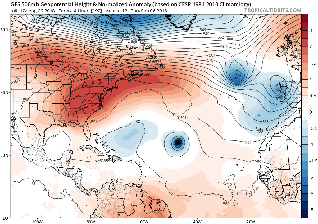
gatorcane wrote:At 192 hours, there is much more ridging over the Northern Atlantic but at that position and strength eventually it should recurve on this run. Question is whether this is the start of a trend?
Bump to new page
0 likes
Re: Tropical Wave in West Africa
chris_fit wrote:Slightly S/W of previous run at 192 hours - probably irrelevant
This should scare Bermuda a little:

937 mb at 228 hrs
Shocked if we don't get an invest based on this GFS run alone.
0 likes
Eyes: Emily '86, Dean '89, Felix '95, Gert '99, Fabian '03, Humberto '19, Paulette '20
-
chris_fit
- Category 5
- Posts: 3078
- Joined: Wed Sep 10, 2003 11:58 pm
- Location: Tampa Bay Area, FL
- Contact:
Re: Tropical Wave in West Africa
up up and away at 240 hours - also nothing really behind it - unlike what the Euro is showing
0 likes
-
cycloneye

- Admin

- Posts: 139071
- Age: 67
- Joined: Thu Oct 10, 2002 10:54 am
- Location: San Juan, Puerto Rico
Re: Tropical Wave in West Africa
Big ACE producer will be if this pans out by GFS.Lowest pressure is 931 mbs.

0 likes
Visit the Caribbean-Central America Weather Thread where you can find at first post web cams,radars
and observations from Caribbean basin members Click Here
and observations from Caribbean basin members Click Here
-
Kazmit

- Category 5
- Posts: 1915
- Age: 21
- Joined: Mon Jul 25, 2016 8:49 am
- Location: Williamsburg VA for college, Bermuda otherwise
Re: Tropical Wave in West Africa
If this makes it to cat 5, this will be the 3rd year in a row with at least one cat 5 in the Atlantic.
2 likes
Igor 2010, Sandy 2012, Fay 2014, Gonzalo 2014, Joaquin 2015, Nicole 2016, Humberto 2019
I am only a tropical weather enthusiast. My predictions are not official and may or may not be backed by sound meteorological data. For official information, please refer to the NHC and NWS products.
I am only a tropical weather enthusiast. My predictions are not official and may or may not be backed by sound meteorological data. For official information, please refer to the NHC and NWS products.
Re: Tropical Wave in West Africa
Kazmit wrote:If this makes it to cat 5, this will be the 3rd year in a row with at least one cat 5 in the Atlantic.
Haha feels crazy to be talking like this when the wave is still over Africa but this is a crazy model run.
3 likes
Eyes: Emily '86, Dean '89, Felix '95, Gert '99, Fabian '03, Humberto '19, Paulette '20

Re: Tropical Wave in West Africa
Hoping that the timing pans out that it just makes it between two highs 12 days out is a bit disconcerting to say the least.
0 likes
-
cycloneye
- Admin
- Posts: 139071
- Age: 67
- Joined: Thu Oct 10, 2002 10:54 am
- Location: San Juan, Puerto Rico
Re: Tropical Wave in West Africa
30%/60%
Tropical Weather Outlook
NWS National Hurricane Center Miami FL
200 PM EDT Wed Aug 29 2018
For the North Atlantic...Caribbean Sea and the Gulf of Mexico:
A vigorous low pressure area associated with a tropical wave is
forecast to form between the coast of Africa and the Cabo Verde
Islands on Thursday. Conditions appears to be favorable for
development, and a tropical depression could form over the weekend
while the system moves west-northwestward near the Cabo Verde
Islands and the adjacent Atlantic. This system is expected to bring
rains and gusty winds to those islands in two or three days, and
interests in that region should monitor the progress of this
disturbance.
* Formation chance through 48 hours...low...30 percent.
* Formation chance through 5 days...medium...60 percent.
$$
Forecaster Avila
1 likes
Visit the Caribbean-Central America Weather Thread where you can find at first post web cams,radars
and observations from Caribbean basin members Click Here
and observations from Caribbean basin members Click Here

Re: Tropical Wave in West Africa
cycloneye wrote:30%/60%Tropical Weather Outlook
NWS National Hurricane Center Miami FL
200 PM EDT Wed Aug 29 2018
For the North Atlantic...Caribbean Sea and the Gulf of Mexico:
A vigorous low pressure area associated with a tropical wave is
forecast to form between the coast of Africa and the Cabo Verde
Islands on Thursday. Conditions appears to be favorable for
development, and a tropical depression could form over the weekend
while the system moves west-northwestward near the Cabo Verde
Islands and the adjacent Atlantic. This system is expected to bring
rains and gusty winds to those islands in two or three days, and
interests in that region should monitor the progress of this
disturbance.
* Formation chance through 48 hours...low...30 percent.
* Formation chance through 5 days...medium...60 percent.
$$
Forecaster Avila

Last edited by SoupBone on Wed Aug 29, 2018 12:57 pm, edited 1 time in total.
4 likes
Personal Forecast Disclaimer:
The posts in this forum are NOT official forecast and should not be used as such. They are just the opinion of the poster and may or may not be backed by sound meteorological data. They are NOT endorsed by any professional institution or storm2k.org. For official information, please refer to the NHC and NWS products.
The posts in this forum are NOT official forecast and should not be used as such. They are just the opinion of the poster and may or may not be backed by sound meteorological data. They are NOT endorsed by any professional institution or storm2k.org. For official information, please refer to the NHC and NWS products.
-
Shell Mound
- Category 5
- Posts: 2434
- Age: 31
- Joined: Thu Sep 07, 2017 3:39 pm
- Location: St. Petersburg, FL → Scandinavia
Re: Tropical Wave in West Africa
ava_ati wrote:Hoping that the timing pans out that it just makes it between two highs 12 days out is a bit disconcerting to say the least.
Ridging would need to be far stronger and deeper to produce a south-of-due-west track. To my eyes, the upcoming ridging is too flat and broken for this system to even threaten Bermuda. This is evident on both the GEFS and EPS ensemble means. Both the GFS and ECMWF indicate fairly quick development and a steady WNW movement through and beyond the Cabo Verde islands. This scenario, given the projected pattern, would only produce a fish, albeit a possible hurricane. So I'm not very concerned about this potential system, and I don't see why anyone else should be, in my humble opinion.
2 likes
CVW / MiamiensisWx / Shell Mound
The posts in this forum are NOT official forecasts and should not be used as such. They are just the opinion of the poster and may or may not be backed by sound meteorological data. They are NOT endorsed by any professional institution or STORM2K. For official information, please refer to products from the NHC and NWS.
-
otowntiger
- Category 5
- Posts: 1787
- Joined: Tue Aug 31, 2004 7:06 pm
- Location: Orlando
Re: Tropical Wave in West Africa
Kazmit wrote:If this makes it to cat 5, this will be the 3rd year in a row with at least one cat 5 in the Atlantic.
And most importantly it looks like it will be a fish. A huge fish, but a fish nonetheless.
1 likes
-
cycloneye
- Admin
- Posts: 139071
- Age: 67
- Joined: Thu Oct 10, 2002 10:54 am
- Location: San Juan, Puerto Rico
Re: Vigorous Low Pressure forms on Thursday between Africa and Cabo Verde Islands
I think at some point on Thursday we will see this area tagged as Invest 90L.
0 likes
Visit the Caribbean-Central America Weather Thread where you can find at first post web cams,radars
and observations from Caribbean basin members Click Here
and observations from Caribbean basin members Click Here
-
cycloneye
- Admin
- Posts: 139071
- Age: 67
- Joined: Thu Oct 10, 2002 10:54 am
- Location: San Juan, Puerto Rico
Re: Vigorous Low Pressure forms on Thursday between Africa and Cabo Verde Islands
12z Euro is much weaker than GFS.
0 likes
Visit the Caribbean-Central America Weather Thread where you can find at first post web cams,radars
and observations from Caribbean basin members Click Here
and observations from Caribbean basin members Click Here
Re: Vigorous Low Pressure forms on Thursday between Africa and Cabo Verde Islands
cycloneye wrote:12z Euro is much weaker than GFS.
What does it say about the track?
0 likes
Eyes: Emily '86, Dean '89, Felix '95, Gert '99, Fabian '03, Humberto '19, Paulette '20
-
cycloneye
- Admin
- Posts: 139071
- Age: 67
- Joined: Thu Oct 10, 2002 10:54 am
- Location: San Juan, Puerto Rico
Re: Vigorous Low Pressure forms on Thursday between Africa and Cabo Verde Islands
plasticup wrote:cycloneye wrote:12z Euro is much weaker than GFS.
What does it say about the track?

1 likes
Visit the Caribbean-Central America Weather Thread where you can find at first post web cams,radars
and observations from Caribbean basin members Click Here
and observations from Caribbean basin members Click Here
-
floridasun78
- Category 5
- Posts: 3755
- Joined: Sun May 17, 2009 10:16 pm
- Location: miami fl
Re: Vigorous Low Pressure forms on Thursday between Africa and Cabo Verde Islands
we love fish 
0 likes
-
gatorcane
- S2K Supporter
- Posts: 23499
- Age: 46
- Joined: Sun Mar 13, 2005 3:54 pm
- Location: Boca Raton, FL
Re: Vigorous Low Pressure forms on Thursday between Africa and Cabo Verde Islands
floridasun78 wrote:we love fish
Fish quiet threads too. Latest GFS continues to show a significant cane recurving over the Central subtropical Atlantic.
But not much commentary here
0 likes
-
cycloneye
- Admin
- Posts: 139071
- Age: 67
- Joined: Thu Oct 10, 2002 10:54 am
- Location: San Juan, Puerto Rico
Re: Vigorous Low Pressure forms on Thursday between Africa and Cabo Verde Islands
40%/70%

Tropical Weather Outlook
NWS National Hurricane Center Miami FL
800 PM EDT Wed Aug 29 2018
For the North Atlantic...Caribbean Sea and the Gulf of Mexico:
A vigorous low pressure area associated with a tropical wave is
forecast to form between the coast of Africa and the Cabo Verde
Islands on Thursday. Conditions appears to be favorable for
subsequent additional development, and a tropical depression is
likely to form by the weekend while the system moves westward or
west-northwestward near the Cabo Verde Islands and the adjacent
Atlantic. This system is expected to bring rains and gusty winds to
those islands in two or three days, and interests in that region
should monitor the progress of this disturbance.
* Formation chance through 48 hours...medium...40 percent.
* Formation chance through 5 days...high...70 percent.
$$
Forecaster Beven
0 likes
Visit the Caribbean-Central America Weather Thread where you can find at first post web cams,radars
and observations from Caribbean basin members Click Here
and observations from Caribbean basin members Click Here
-
toad strangler

- S2K Supporter
- Posts: 4162
- Joined: Sun Jul 28, 2013 3:09 pm
- Location: Earth
- Contact:
Re: Vigorous Low Pressure forms on Thursday between Africa and Cabo Verde Islands
floridasun78 wrote:we love fish
Not me. Bad for my business. But I respect the fish lover.
0 likes
Who is online
Users browsing this forum: Gums, Hurricane2022, nativefloridian, NotSparta and 210 guests