

Coastal Flood Warning
MDZ021>023-112030-/O.EXT.KAKQ.CF.W.0005.000000T0000Z-180912T0200Z/Dorchester-Wicomico-Somerset-825 AM EDT Tue Sep 11 2018...COASTAL FLOOD WARNING NOW IN EFFECT UNTIL 10 PM EDT THISEVENING...* LOCATION...Areas adjacent to the Chesapeake Bay on the lower Maryland Eastern Shore, including tidal tributaries.* TIMING...Through the high tide cycle late this evening.* COASTAL FLOOD IMPACTS...Widespread flooding of vulnerable areas will result in an elevated threat of property damage to homes and businesses near the waterfront and shoreline. Water will be 1 to 2 feet above ground level in some areas resulting in a sufficient depth to close numerous roads and threaten homes and businesses. Flooding will extend inland from the waterfront along tidal rivers and bays resulting in some road closures and flooding of vehicles.PRECAUTIONARY/PREPAREDNESS ACTIONS...A Coastal Flood Warning means that flooding is occurring orimminent. Coastal residents in the warned area should be alertfor rising water...and take appropriate action to protect lifeand property. Be prepared for the possibility of road closuresand flooding of properties. If travel is necessary...do notattempt to drive through water of unknown depth.&&Time of high total tides are approximate to the nearest hour.CAMBRIDGE MDMLLW CATEGORIES - MINOR 3.5 FT, MODERATE 4.0 FT, MAJOR 4.5 FTMHHW CATEGORIES - MINOR 1.5 FT, MODERATE 2.0 FT, MAJOR 2.5 FT TOTAL TOTAL DEPARTURE DAY/TIME TIDE TIDE FROM NORM WAVES FLOOD FT MLLW FT MHHW FT FT IMPACT -------- --------- --------- --------- ------- -------- 11/07 AM 3.8 1.8 1.6 1 MINOR 11/06 PM 3.7 1.7 1.4 1 MINOR 12/07 AM 3.5 1.5 1.2 1 MINOR 12/07 PM 3.4 1.4 1.1 1 NONE 13/07 AM 3.3 1.3 1.1 1 NONE 13/08 PM 3.5 1.5 1.2 2 MINORBISHOPS HEAD MDMLLW CATEGORIES - MINOR 3.3 FT, MODERATE 3.8 FT, MAJOR 4.3 FTMHHW CATEGORIES - MINOR 1.2 FT, MODERATE 1.7 FT, MAJOR 2.2 FT TOTAL TOTAL DEPARTURE DAY/TIME TIDE TIDE FROM NORM WAVES FLOOD FT MLLW FT MHHW FT FT IMPACT -------- --------- --------- --------- ------- -------- 11/03 PM 4.0 1.9 1.4 1 MODERATE 12/04 AM 3.7 1.6 1.2 1 MODERATE 12/04 PM 3.6 1.5 1.0 1 MINOR 13/05 AM 3.6 1.5 1.2 1-2 MINOR 13/05 PM 3.8 1.7 1.3 2 MODERATE 14/05 AM 3.9 1.8 1.7 2 MODERATESAXIS VA TOTAL TOTAL DEPARTURE DAY/TIME TIDE TIDE FROM NORM WAVES FLOOD FT MLLW FT MHHW FT FT IMPACT -------- --------- --------- --------- ------- -------- 11/02 PM 4.3 1.8 1.2 1 12/02 AM 3.8 1.3 0.9 1 12/03 PM 4.0 1.5 0.9 1 13/03 AM 3.5 1.0 0.8 1-2 13/04 PM 3.9 1.4 0.9 2 14/04 AM 3.7 1.2 1.2 2-3&&$$
ATL: FLORENCE - Evacuations, Closings, Webcams, Observations
Moderator: S2k Moderators
Forum rules

The posts in this forum are NOT official forecasts and should not be used as such. They are just the opinion of the poster and may or may not be backed by sound meteorological data. They are NOT endorsed by any professional institution or STORM2K. For official information, please refer to products from the National Hurricane Center and National Weather Service.
Re: ATL: FLORENCE - Evacuations, Closings, Webcams, Observations
Pet-friendly emergency shelters you can choose ahead of Hurricane Florence
Some shelters are not pet-friendly but here are a few that are:
Norfolk:
Pet-friendly shelters are located at Bayview Recreation Center and Berkley Community Center. Like the other shelters, it will be announced when the shelter is available and accepting pets. Be sure to bring your pet’s shelter permitted provisions.
Suffolk:
Nansemond River High School, 3301 Nansemond Parkway (ADA compliant, pet-friendly, generator power for emergency lighting and to support the kitchen freezers only).
If you know of any other pet-friendly shelters email us at desk@wtkr.com.
0 likes
Re: ATL: FLORENCE - Evacuations, Closings, Webcams, Observations
https://www.13newsnow.com/article/news/ ... -592817059
Do remember, shelters ask that you bring enough water and non perishable food to last 3 days for each person.
Don’t forget pet food, and don’t forget a can opener.
Do remember, shelters ask that you bring enough water and non perishable food to last 3 days for each person.
Don’t forget pet food, and don’t forget a can opener.
0 likes
Re: ATL: FLORENCE - Evacuations, Closings, Webcams, Observations
SC governor lifts mandatory evacuation order for Beaufort, Jasper and Colleton counties
http://www.wtoc.com/story/39061644/gov- ... n-counties
http://www.wtoc.com/story/39061644/gov- ... n-counties
0 likes
Re: ATL: FLORENCE - Evacuations, Closings, Webcams, Observations
TYBEE ISLAND, GA (WTOC) -
Even though Georgia is no longer in the cone of uncertainty of Hurricane Florence, it doesn't mean Georgia's coast will not see an impact.
The sun may be shining right now on Tybee Island and people may be enjoying the beach and waves, but at the same time, emergency crews are making sure they have all plans in place just in case any bad weather does come this way.
Chatham Emergency Management Agency (CEMA) has been meeting throughout the day Monday to make sure they have plans in place for Hurricane Florence. Right now, they are operating in condition 4 which means they are actively monitoring the storm and keeping the emergency operations center activated throughout the day. CEMA says they've been coordinating with partners to make sure everything is in order.
One area of concern is the coast, which would include Tybee Island.
"They have a really high risk of rip currents that are going to be affecting them over the next several days," said Dennis Jones, Director of Chatham Emergency Management Agency. "Beach erosion. That's a significant issue for the city of Tybee Island, and we are also entering into a period to where we have above average tides - not associated with the storm. That's just the normal tide sequence."
Tybee Mayor Jason Buelterman says he's encouraging people who live on the island to pay close attention to the hurricane updates and be prepared ahead of time.
http://www.wtoc.com/story/39062730/tybe ... e-florence
0 likes

Re: ATL: FLORENCE - Evacuations, Closings, Webcams, Observations
artist wrote:SC governor lifts mandatory evacuation order for Beaufort, Jasper and Colleton counties
http://www.wtoc.com/story/39061644/gov- ... n-counties
I hope he also stated that it is highly recommended to leave. I'm guessing these are the 3 counties that are outside the cone. I think he should of just changed the time of the mandatory evacuations to noon tomorrow for those counties, so they would still be prepared, then changed it tomorrow morning if it looks like Florence will be coming in at the NC/SC border or further North.
1 likes
Personal Forecast Disclaimer:
The posts in this forum are NOT official forecast and should not be used as such. They are just the opinion of the poster and may or may not be backed by sound meteorological data. They are NOT endorsed by any professional institution or storm2k.org. For official information, please refer to the NHC and NWS products.
The posts in this forum are NOT official forecast and should not be used as such. They are just the opinion of the poster and may or may not be backed by sound meteorological data. They are NOT endorsed by any professional institution or storm2k.org. For official information, please refer to the NHC and NWS products.
Re: ATL: FLORENCE - Evacuations, Closings, Webcams, Observations
Don’t forget to take all your medications with you.
0 likes
Re: ATL: FLORENCE - Evacuations, Closings, Webcams, Observations
Blinhart wrote:artist wrote:SC governor lifts mandatory evacuation order for Beaufort, Jasper and Colleton counties
http://www.wtoc.com/story/39061644/gov- ... n-counties
I hope he also stated that it is highly recommended to leave. I'm guessing these are the 3 counties that are outside the cone. I think he should of just changed the time of the mandatory evacuations to noon tomorrow for those counties, so they would still be prepared, then changed it tomorrow morning if it looks like Florence will be coming in at the NC/SC border or further North.
With the latest Euro, it might of been a big mistake if does what it shows.
1 likes
Personal Forecast Disclaimer:
The posts in this forum are NOT official forecast and should not be used as such. They are just the opinion of the poster and may or may not be backed by sound meteorological data. They are NOT endorsed by any professional institution or storm2k.org. For official information, please refer to the NHC and NWS products.
The posts in this forum are NOT official forecast and should not be used as such. They are just the opinion of the poster and may or may not be backed by sound meteorological data. They are NOT endorsed by any professional institution or storm2k.org. For official information, please refer to the NHC and NWS products.
Re: ATL: FLORENCE - Evacuations, Closings, Webcams, Observations
CHARLESTON, SC (WCSC) -
GasBuddy is now monitoring fuel outages at Lowcountry gas stations as people rush to fill their tanks.
CLICK HERE to search for fuel in your city or town.
South Carolina
https://tracker.gasbuddy.com/?q=South%20Carolina
North Carolina. Quite a few are low
https://tracker.gasbuddy.com/?q=North%20Carolina
Virginia
https://tracker.gasbuddy.com/?q=Virginia
Their fuel tracker is monitoring Lowcountry stations based on whether they have power or fuel.
As of Tuesday morning, GasBuddy showed the lowest prices for gas at around $2.43 per gallon at stations in Charleston and North Charleston.
Stations with fuel and power are indicated with green pins on a map. Those with no power are shown in black. Yellow pins indicate stations with limited fuel options and those with no fuel or power are indicated in red.
Copyright 2018 WCSC. All rights reserved.
http://www.live5news.com/story/39068064 ... d-out-here
0 likes
Re: ATL: FLORENCE - Evacuations, Closings, Webcams, Observations
Charleston and Savannah nws hurricane statement
https://forecast.weather.gov/showsigwx. ... n=-81.0912
https://forecast.weather.gov/showsigwx. ... n=-81.0912
0 likes
Re: ATL: FLORENCE - Evacuations, Closings, Webcams, Observations
Coastal Flood Advisory
Coastal Hazard Message
National Weather Service Jacksonville FL
340 PM EDT Tue Sep 11 2018
FLZ124-125-133-138-GAZ154-166-120900-
/O.CON.KJAX.CF.Y.0005.000000T0000Z-180915T0000Z/
/O.CON.KJAX.RP.S.0021.000000T0000Z-180915T0000Z/
Coastal Nassau-Coastal Duval-Coastal St. Johns-Coastal Flagler-
Coastal Glynn-Coastal Camden-
340 PM EDT Tue Sep 11 2018
...COASTAL FLOOD ADVISORY REMAINS IN EFFECT UNTIL 8 PM EDT
FRIDAY...
...HIGH RIP CURRENT RISK REMAINS IN EFFECT THROUGH FRIDAY
EVENING...
* SURF AND RIP CURRENT RISK...Life-threatening rip currents will
be possible at northeast Florida and southeast Georgia
beaches.
* COASTAL FLOODING...Minor tidal flooding potential around daily
high tides. Minor beach erosion possible. Peak water levels
expected Thursday.
* IMPACTS...Minor tidal flooding may impact low lying areas,
parks, beaches, campgrounds, boat ramps, and some docks around
high tide.
0 likes
Re: ATL: FLORENCE - Evacuations, Closings, Webcams, Observations
SUMMARY OF 500 PM AST...2100 UTC...INFORMATION
----------------------------------------------
LOCATION...27.5N 67.1W
ABOUT 360 MI...580 KM SSW OF BERMUDA
ABOUT 785 MI...1260 KM ESE OF CAPE FEAR NORTH CAROLINA
MAXIMUM SUSTAINED WINDS...140 MPH...220 KM/H
PRESENT MOVEMENT...WNW OR 300 DEGREES AT 17 MPH...28 KM/H
MINIMUM CENTRAL PRESSURE...945 MB...27.91 INCHES
0 likes
Re: ATL: FLORENCE - Evacuations, Closings, Webcams, Observations
If anyone is looking for info you don’t see here, just ask and I will see if I can locate it.
0 likes
Re: ATL: FLORENCE - Evacuations, Closings, Webcams, Observations
SURF: Swells generated by Florence are affecting Bermuda and
portions of the U.S. East Coast. These swells are likely to cause
life-threatening surf and rip current conditions. Please consult
products from your local weather office.
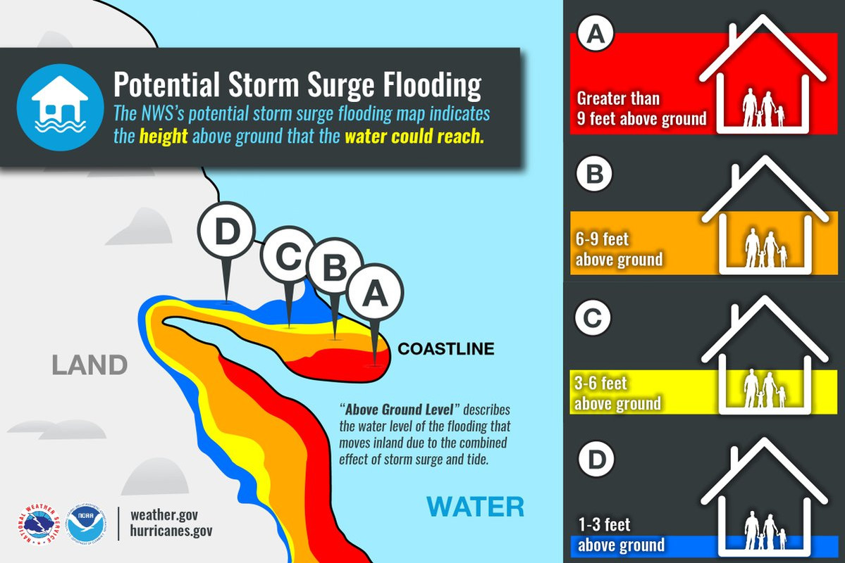
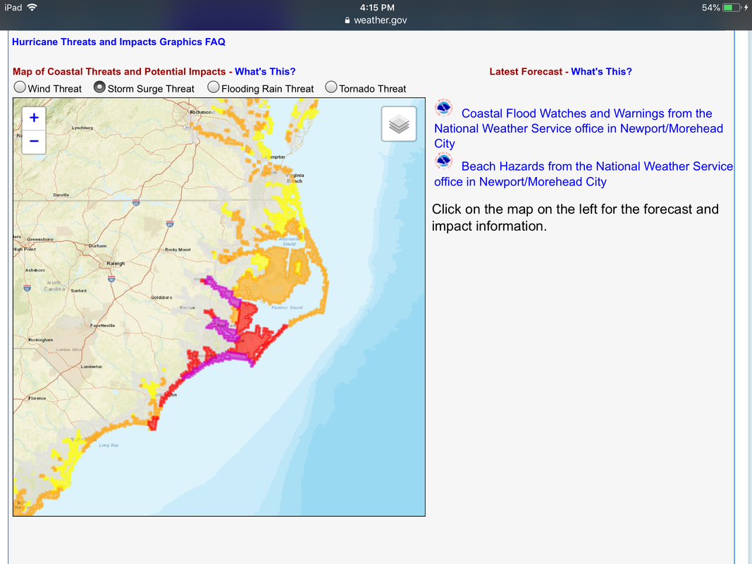
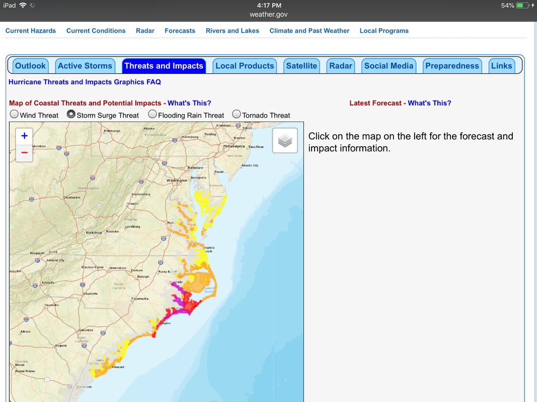
STORM SURGE: The combination of a dangerous storm surge and the
tide will cause normally dry areas near the coast to be flooded by
rising waters moving inland from the shoreline. The water has the
potential to reach the following heights above ground if peak surge
occurs at the time of high tide...
Cape Fear to Cape Lookout, including the Neuse and Pamlico
Rivers...9-13 ft
North Myrtle Beach to Cape Fear...6-9 ft
Cape Lookout to Ocracoke Inlet...6-9 ft
South Santee River to North Myrtle Beach...4-6 ft
Ocracoke Inlet to North Carolina/Virginia Border...4-6 ft
Edisto Beach to South Santee River...2-4 ft
The deepest water will occur along the immediate coast in areas of
onshore winds, where the surge will be accompanied by large and
destructive waves. Surge-related flooding depends on the relative
timing of the surge and the tidal cycle, and can vary greatly over
short distances. For information specific to your area, please see
products issued by your local National Weather Service forecast
office.
portions of the U.S. East Coast. These swells are likely to cause
life-threatening surf and rip current conditions. Please consult
products from your local weather office.
STORM SURGE: The combination of a dangerous storm surge and the
tide will cause normally dry areas near the coast to be flooded by
rising waters moving inland from the shoreline. The water has the
potential to reach the following heights above ground if peak surge
occurs at the time of high tide...
Cape Fear to Cape Lookout, including the Neuse and Pamlico
Rivers...9-13 ft
North Myrtle Beach to Cape Fear...6-9 ft
Cape Lookout to Ocracoke Inlet...6-9 ft
South Santee River to North Myrtle Beach...4-6 ft
Ocracoke Inlet to North Carolina/Virginia Border...4-6 ft
Edisto Beach to South Santee River...2-4 ft
The deepest water will occur along the immediate coast in areas of
onshore winds, where the surge will be accompanied by large and
destructive waves. Surge-related flooding depends on the relative
timing of the surge and the tidal cycle, and can vary greatly over
short distances. For information specific to your area, please see
products issued by your local National Weather Service forecast
office.
0 likes
Re: ATL: FLORENCE - Evacuations, Closings, Webcams, Observations
College football games effected by Hurricane Florence, some moved dates and times, some canceled, some hoping to reschedule.
https://www.usatoday.com/story/sports/n ... 272231002/
https://www.usatoday.com/story/sports/n ... 272231002/
1 likes
Personal Forecast Disclaimer:
The posts in this forum are NOT official forecast and should not be used as such. They are just the opinion of the poster and may or may not be backed by sound meteorological data. They are NOT endorsed by any professional institution or storm2k.org. For official information, please refer to the NHC and NWS products.
The posts in this forum are NOT official forecast and should not be used as such. They are just the opinion of the poster and may or may not be backed by sound meteorological data. They are NOT endorsed by any professional institution or storm2k.org. For official information, please refer to the NHC and NWS products.
Re: ATL: FLORENCE - Evacuations, Closings, Webcams, Observations
Flood Warning
National Weather Service Wilmington NC
1231 AM EDT Wed Sep 12 2018
...The National Weather Service in Wilmington NC has issued a Flood Warning for
the following river in North Carolina...
Northeast Cape Fear Near Burgaw affecting Pender County
PRECAUTIONARY/PREPAREDNESS ACTIONS...
People with interests along the river should take the necessary precautions to
protect life and property from the flood waters.
Additional information is available on our website at weather.gov/ilm under the
"Rivers and Lakes" link.
&&
NCC141-122031-
/O.NEW.KILM.FL.W.0008.180915T0842Z-000000T0000Z/
/BGWN7.3.ER.180915T0842Z.180917T0000Z.000000T0000Z.NO/
1231 AM EDT Wed Sep 12 2018
The National Weather Service in Wilmington NC has issued a
* Flood Warning for
The Northeast Cape Fear Near Burgaw
* from late Friday night until further notice.
* At 11:30 PM Tuesday the stage was 2.36 feet.
* Flood stage is 10.0 feet.
* Major flooding is forecast.
* Forecast...Rise above flood stage by early Saturday morning and continue to
rise to near 20.0 feet by Sunday evening. Additional rises are possible
thereafter.
0 likes
Who is online
Users browsing this forum: No registered users and 147 guests