

SCEMD Retweeted
SCE&G
SCE&G
@scegnews
·
Sep 10
In anticipation of Hurricane
#Florence
's potential impact on the Saluda Basin, we are releasing water from Lake Murray through our Saluda Hydro facility. Right now the lake is at 356.7' and we will continue to manage it throughout the storm. View levels: (link: http://sceg.com/about-us/lakes-and-recreation) sceg.com/about-us/lakes….
ATL: FLORENCE - Evacuations, Closings, Webcams, Observations
Moderator: S2k Moderators
Forum rules

The posts in this forum are NOT official forecasts and should not be used as such. They are just the opinion of the poster and may or may not be backed by sound meteorological data. They are NOT endorsed by any professional institution or STORM2K. For official information, please refer to products from the National Hurricane Center and National Weather Service.
Re: ATL: FLORENCE - Evacuations, Closings, Webcams, Observations
VDEM Retweeted
NWS Blacksburg
NWS Blacksburg
@NWSBlacksburg
·
1h
Very heavy rainfall tracking across eastern Watauga County and northward from Caldwell and Avery County. Flash flooding around Boone and across eastern Watauga County is imminent!
NWS Blacksburg
NWS Blacksburg
@NWSBlacksburg
·
1h
Very heavy rainfall tracking across eastern Watauga County and northward from Caldwell and Avery County. Flash flooding around Boone and across eastern Watauga County is imminent!
0 likes
Re: ATL: FLORENCE - Evacuations, Closings, Webcams, Observations
VDEM Retweeted
8News WRIC Richmond
8News WRIC Richmond
@8NEWS
·
2h
Local schools announce closings in anticipation of Hurricane Florence
(link: http://bit.ly/2MkrmNu) bit.ly/2MkrmNu
8News WRIC Richmond
8News WRIC Richmond
@8NEWS
·
2h
Local schools announce closings in anticipation of Hurricane Florence
(link: http://bit.ly/2MkrmNu) bit.ly/2MkrmNu
0 likes
Re: ATL: FLORENCE - Evacuations, Closings, Webcams, Observations
Georgia EM&HS
Georgia EM&HS
@GeorgiaEMA
·
15h
Some pet friendly sheltering is now available at
@GaStateParks
, where "dry camping" will be available free of charge.
#Florence
evacuees are encouraged to contact park offices directly for assistance. A map of all Georgia State Parks is available at (link: https://gastateparks.org/Map) gastateparks.org/Map.
0 likes
Re: ATL: FLORENCE - Evacuations, Closings, Webcams, Observations
There are currently no evacuation orders or declared states of emergency for Georgia.
0 likes
Re: ATL: FLORENCE - Evacuations, Closings, Webcams, Observations
http://flhurricane.com/cyclone/animatio ... %282018%29 has a bunch of webcam time lapses going (they usually do this for storms)
2 likes
-
ftolmsteen

- Tropical Storm

- Posts: 121
- Joined: Mon Jun 25, 2007 6:34 am
- Location: Port Richey, FL
Re: ATL: FLORENCE - Evacuations, Closings, Webcams, Observations
https://www.ndbc.noaa.gov/images/buoyca ... 2_1610.jpg
Buoy just about took a direct hit. 34 foot waves caught on camera from buoy.
Buoy just about took a direct hit. 34 foot waves caught on camera from buoy.
3 likes

Re: ATL: FLORENCE - Evacuations, Closings, Webcams, Observations
Thanks for that fantastic buoy link. The page for buoy 41048 says that this it is currently adrift. Will be interesting to see where it goes. I looked up its coordinates and it is quite close to the center of Florence right now.
Buoy's last reported location: 30.9921 -70.5382
Florence most recent NHC location: 30.4°N 71.8°W
Buoy page: https://www.ndbc.noaa.gov/station_page.php?station=41048
Buoy's last reported location: 30.9921 -70.5382
Florence most recent NHC location: 30.4°N 71.8°W
Buoy page: https://www.ndbc.noaa.gov/station_page.php?station=41048
1 likes
-
elkiehound
- Tropical Wave

- Posts: 1
- Joined: Tue Sep 11, 2018 3:37 pm
Re: ATL: FLORENCE - Evacuations, Closings, Webcams, Observations
Nice sunset 34 miles offshore NC. https://explore.org/livecams/currently- ... ng-pan-cam
1 likes
-
Jevo

- S2K Supporter

- Posts: 1729
- Age: 46
- Joined: Tue Aug 03, 2004 8:45 pm
- Location: The Flemish Cap
- Contact:
Re: ATL: FLORENCE - Evacuations, Closings, Webcams, Observations
elkiehound wrote:Nice sunset 34 miles offshore NC. https://explore.org/livecams/currently- ... ng-pan-cam
Looks like the site is having issues.. Direct Youtube link to that cam... It's ripping out there right now
https://www.youtube.com/watch?v=deG4NxkouGM
2 likes
Disclaimer: 50% of the time I have no clue of what I am talking about. Chances are I am taking a less than educated guess that sounds good because 10 years ago I stole Mike Watkins book 'The Hurricane and its Impact'. For official information please direct yourself to the NHC and their cadre of weather geniuses.
Re: ATL: FLORENCE - Evacuations, Closings, Webcams, Observations
From yesterday
NHC_TAFB
NHC_TAFB
@NHC_TAFB
Wave heights to 83 ft were measured early this morning under the NE quadrant of Hurricane Florence. These enormous waves are produced by being trapped along with very strong winds moving in the same direction the storm's motion.
NHC_TAFB
NHC_TAFB
@NHC_TAFB
Wave heights to 83 ft were measured early this morning under the NE quadrant of Hurricane Florence. These enormous waves are produced by being trapped along with very strong winds moving in the same direction the storm's motion.
0 likes
Re: ATL: FLORENCE - Evacuations, Closings, Webcams, Observations
Everyone please leave that needs to. Please. 83 ft wave heights measures to the ne of the storm yesterday, according to the NHC.
Stay safe, our thoughts and prayers with all. Check in when you are able. We don’t rest until we hear from everyone.
Stay safe, our thoughts and prayers with all. Check in when you are able. We don’t rest until we hear from everyone.
0 likes
Re: ATL: FLORENCE - Evacuations, Closings, Webcams, Observations
Updated statement from the NHC issued 2 minutes ago-
666
WTNT61 KNHC 131355
TCUAT1
Hurricane Florence Tropical Cyclone Update
NWS National Hurricane Center Miami FL AL062018
1000 AM EDT Thu Sep 13 2018
...HEAVY RAINBANDS WITH TROPICAL-STORM-FORCE WINDS SPREADING ACROSS
THE OUTER BANKS AND COASTAL SOUTHEASTERN NORTH CAROLINA...
...LIFE-THREATENING STORM SURGE AND RAINFALL EXPECTED...
Data from an Air Force Reserve Unit Hurricane Hunter aircraft and
NOAA Doppler weather radars from Morehead City and Wilmington,
North Carolina, indicate that Florence has changed little. Maximum
sustained winds remain near 110 mph (175 km/h). The latest minimum
central pressure based on data from the aircraft is 955 mb (28.20
inches). NOAA Buoy 41025, located near Diamond Shoals, North
Carolina, recently reported a sustained wind of 54 mph...87 km/h
and a gust to 59 mph...94 km/h. A wind gust to 51 mph...81 km/h was
recently reported in Morehead City, North Carolina.
SUMMARY OF 1000 AM EDT...1400 UTC...INFORMATION
----------------------------------------------
LOCATION...33.3N 75.4W
ABOUT 160 MI...255 KM ESE OF WILMINGTON NORTH CAROLINA
ABOUT 205 MI...330 KM E OF MYRTLE BEACH SOUTH CAROLINA
MAXIMUM SUSTAINED WINDS...110 MPH...175 KM/H
PRESENT MOVEMENT...NW OR 315 DEGREES AT 10 MPH...17 KM/H
MINIMUM CENTRAL PRESSURE...955 MB...28.20 INCHES
$$
Forecaster Stewart
0 likes

Re: ATL: FLORENCE - Evacuations, Closings, Webcams, Observations
Jevo wrote:elkiehound wrote:Nice sunset 34 miles offshore NC. https://explore.org/livecams/currently- ... ng-pan-cam
Looks like the site is having issues.. Direct Youtube link to that cam... It's ripping out there right now
https://www.youtube.com/watch?v=deG4NxkouGM
Sure enough. That flag will be in tatters soon. I wonder how long the camera will last out there?
0 likes
Re: ATL: FLORENCE - Evacuations, Closings, Webcams, Observations
NHC_Surge
@NHC_Surge
·
17h
Given the rarity of the magnitude of
#Florence
's storm surge forecast, it can be hard to grasp what that might look like or the impacts it could have on your community. We ask that you heed evacuation orders for your area if issued by local authorities. Time is running short!
@NHC_Surge
·
17h
Given the rarity of the magnitude of
#Florence
's storm surge forecast, it can be hard to grasp what that might look like or the impacts it could have on your community. We ask that you heed evacuation orders for your area if issued by local authorities. Time is running short!
0 likes
Re: ATL: FLORENCE - Evacuations, Closings, Webcams, Observations
https://alerts.weather.gov/cap/wwacapge ... 7dffe69a21
Message: NOAA-NWS-ALERTS-NC125ABC28DF9C.FloodWarning.125ABC36E95CNC.ILMFLSILM.f7ca0c85747112fd85b87f7dffe69a21 from w-nws.webmaster@noaa.gov
Sent: 11:19 EDT on 09-13-2018
Effective: 06:27 EDT on 09-15-2018
Expires: 03:19 EDT on 09-14-2018
Event: Flood Warning
Alert:
...The Flood Warning has been extended for the following rivers...
Northeast Cape Fear Near Burgaw affecting Pender County NC
...Flood Warning now in effect until further notice...
The Flood Warning continues for
The Northeast Cape Fear Near Burgaw.
* from Saturday morning until further notice.
* At 10:30 AM Thursday the stage was 2.60 feet.
* Flood stage is 10.0 feet.
* Major flooding is forecast.
* Forecast...Rise above flood stage by Saturday morning and continue to rise to
near 24.0 feet by early Tuesday morning.
* Impact...At 22.4 feet...12 miles of Highway 53 are underwater,in some cases 7
feet deep, between the Northeast Cape Fear bridge and Maple Hill. All homes
including 60 in River Bend, 20 to 25 in River Birch and 12 in the Alligator
Lake subdivision are flooded. 20 to 30 homes in Holly Shelter estates are
underwater. In the Sandy Bend subdivision, off Shaw Highway, 40 to 50 homes,
which is half of the homes in the subdivision sustain flooding. Portions of
Croomsbridge, Island Creek and White Stocking Roads are underwater.
&&
0 likes
Re: ATL: FLORENCE - Evacuations, Closings, Webcams, Observations
Message: NOAA-NWS-ALERTS-NC125ABC28DA24.StormSurgeWarning.125ABC2A168CNC.MHXTCVMHX.6b6ed11d4e98b808354761316fc1ca6a from w-nws.webmaster@noaa.gov
Sent: 11:05 EDT on 09-13-2018
Effective: 11:05 EDT on 09-13-2018
Expires: 19:15 EDT on 09-13-2018
Event: Storm Surge Warning
Alert:
...HURRICANE WARNING REMAINS IN EFFECT...
...STORM SURGE WARNING REMAINS IN EFFECT...
* LOCATIONS AFFECTED
- Trenton
- Maysville
- Pollocksville
* WIND
- LATEST LOCAL FORECAST: Equivalent Strong Tropical Storm force
wind
- Peak Wind Forecast: 50-65 mph with gusts to 80 mph
- Window for Tropical Storm force winds: until early Saturday
morning
- POTENTIAL THREAT TO LIFE AND PROPERTY: Potential for wind
greater than 110 mph
- The wind threat has remained nearly steady from the
previous assessment.
- PLAN: Plan for extreme wind of equivalent CAT 3 hurricane
force or higher due to possible forecast changes in track,
size, or intensity.
- PREPARE: Last minute efforts should solely focus on
protecting life. The area remains subject to catastrophic
wind damage.
- ACT: Now is the time to shelter from life-threatening wind.
Be ready to move to the safest place inside your shelter if
necessary.
- POTENTIAL IMPACTS: Unfolding
- Potential impacts from the main wind event are unfolding.
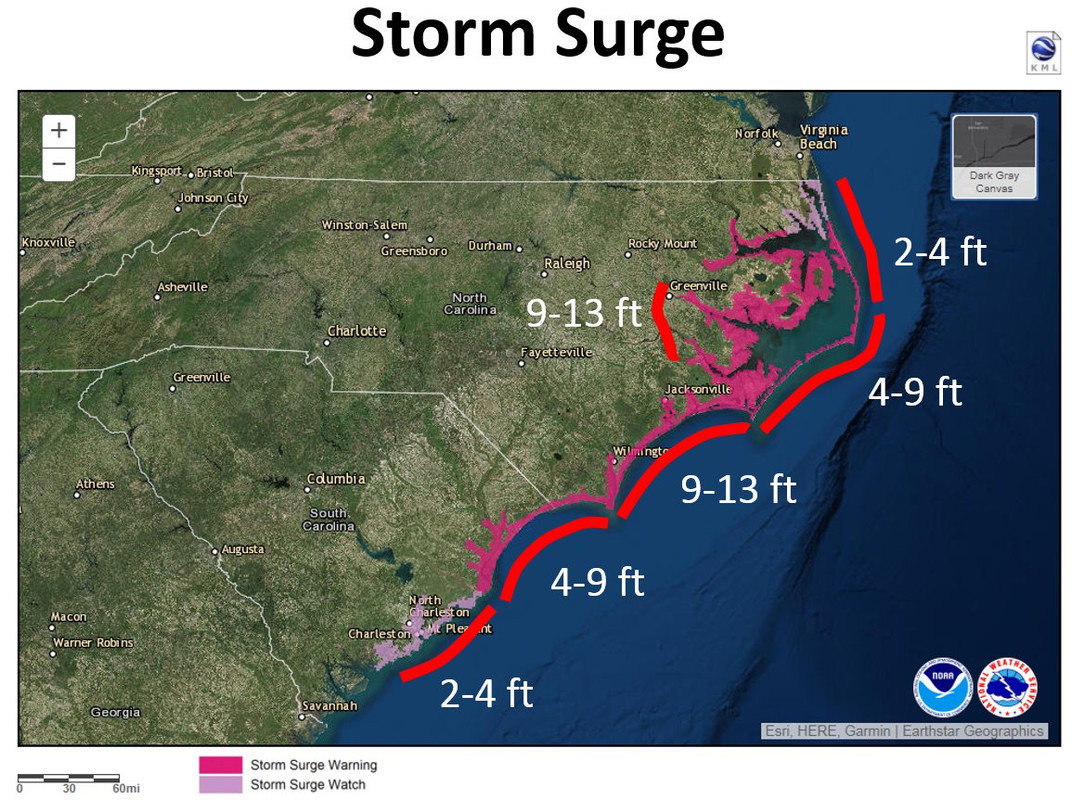
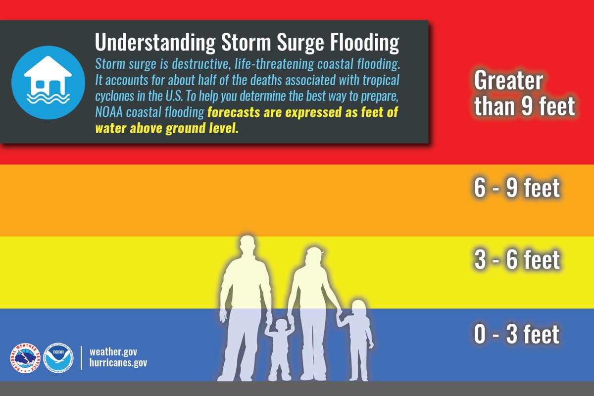
* STORM SURGE
- LATEST LOCAL FORECAST: Life-threatening and historic storm
surge possible
- Peak Storm Surge Inundation: The potential for 9-13 feet
above ground somewhere within surge prone areas
- Window of concern: through early Sunday afternoon
- POTENTIAL THREAT TO LIFE AND PROPERTY: Potential for storm
surge flooding greater than 9 feet above ground
- The storm surge threat has remained nearly steady from the
previous assessment.
- PLAN: Shelter against extreme life-threatening storm surge
flooding greater than 9 feet above ground.
- PREPARE: All ordered evacuations should be complete.
Evacuees should be in shelters well away from storm surge
flooding.
- ACT: Remain sheltered in a safe location. Do not venture
outside. Move to upper floors to escape rising water if
necessary.
- POTENTIAL IMPACTS: Unfolding
- Potential impacts from the main surge event are unfolding.
https://alerts.weather.gov/cap/wwacapge ... 316fc1ca6a
Sent: 11:05 EDT on 09-13-2018
Effective: 11:05 EDT on 09-13-2018
Expires: 19:15 EDT on 09-13-2018
Event: Storm Surge Warning
Alert:
...HURRICANE WARNING REMAINS IN EFFECT...
...STORM SURGE WARNING REMAINS IN EFFECT...
* LOCATIONS AFFECTED
- Trenton
- Maysville
- Pollocksville
* WIND
- LATEST LOCAL FORECAST: Equivalent Strong Tropical Storm force
wind
- Peak Wind Forecast: 50-65 mph with gusts to 80 mph
- Window for Tropical Storm force winds: until early Saturday
morning
- POTENTIAL THREAT TO LIFE AND PROPERTY: Potential for wind
greater than 110 mph
- The wind threat has remained nearly steady from the
previous assessment.
- PLAN: Plan for extreme wind of equivalent CAT 3 hurricane
force or higher due to possible forecast changes in track,
size, or intensity.
- PREPARE: Last minute efforts should solely focus on
protecting life. The area remains subject to catastrophic
wind damage.
- ACT: Now is the time to shelter from life-threatening wind.
Be ready to move to the safest place inside your shelter if
necessary.
- POTENTIAL IMPACTS: Unfolding
- Potential impacts from the main wind event are unfolding.
* STORM SURGE
- LATEST LOCAL FORECAST: Life-threatening and historic storm
surge possible
- Peak Storm Surge Inundation: The potential for 9-13 feet
above ground somewhere within surge prone areas
- Window of concern: through early Sunday afternoon
- POTENTIAL THREAT TO LIFE AND PROPERTY: Potential for storm
surge flooding greater than 9 feet above ground
- The storm surge threat has remained nearly steady from the
previous assessment.
- PLAN: Shelter against extreme life-threatening storm surge
flooding greater than 9 feet above ground.
- PREPARE: All ordered evacuations should be complete.
Evacuees should be in shelters well away from storm surge
flooding.
- ACT: Remain sheltered in a safe location. Do not venture
outside. Move to upper floors to escape rising water if
necessary.
- POTENTIAL IMPACTS: Unfolding
- Potential impacts from the main surge event are unfolding.
https://alerts.weather.gov/cap/wwacapge ... 316fc1ca6a
0 likes
Re: ATL: FLORENCE - Evacuations, Closings, Webcams, Observations
Link to current NWS warnings per state
https://alerts.weather.gov/cap/nc.php?x=1
https://alerts.weather.gov/cap/sc.php?x=1
https://alerts.weather.gov/cap/va.php?x=1
https://alerts.weather.gov/cap/ga.php?x=1
https://alerts.weather.gov/cap/md.php?x=1
https://alerts.weather.gov/cap/dc.php?x=1
https://alerts.weather.gov/cap/nc.php?x=1
https://alerts.weather.gov/cap/sc.php?x=1
https://alerts.weather.gov/cap/va.php?x=1
https://alerts.weather.gov/cap/ga.php?x=1
https://alerts.weather.gov/cap/md.php?x=1
https://alerts.weather.gov/cap/dc.php?x=1
0 likes

Re: ATL: FLORENCE - Evacuations, Closings, Webcams, Observations
Jeff Piotrowski stream in NC (sorry if this has already been posted). Latest video about 30 minutes ago.
https://www.pscp.tv/Jeff_Piotrowski/1rmGPNXPPOQxN
https://www.pscp.tv/Jeff_Piotrowski/1rmGPNXPPOQxN
2 likes
Who is online
Users browsing this forum: Blown Away, gib, Google [Bot], Google Adsense [Bot], Teban54 and 85 guests