

This is good to know-
VFW National HQ
@VFWHQ
·
12m
Attention
@USAA
members: If you are evacuated because of
#HurricaneFlorence
and you have homeowners or renters insurance through USAA, call them and let them know and they will pay for your gas, food and hotel to evacuate. 1-800-531-8722
ATL: FLORENCE - Evacuations, Closings, Webcams, Observations
Moderator: S2k Moderators
Forum rules

The posts in this forum are NOT official forecasts and should not be used as such. They are just the opinion of the poster and may or may not be backed by sound meteorological data. They are NOT endorsed by any professional institution or STORM2K. For official information, please refer to products from the National Hurricane Center and National Weather Service.
Re: ATL: FLORENCE - Evacuations, Closings, Webcams, Observations
@NC_Governor
provides an update on
#HurricaneFlorence
. (link: https://fxn.ws/2MvKmJb) fxn.ws/2MvKmJb
provides an update on
#HurricaneFlorence
. (link: https://fxn.ws/2MvKmJb) fxn.ws/2MvKmJb
0 likes
Re: ATL: FLORENCE - Evacuations, Closings, Webcams, Observations
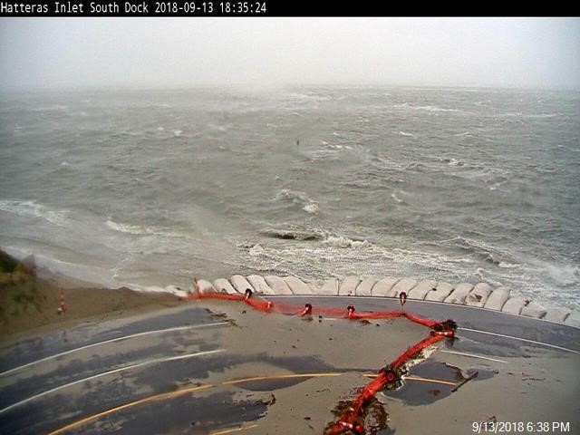
Event: Flash Flood Warning
Alert:
The National Weather Service in Newport has issued a
* Flash Flood Warning for...
Southeastern Dare County in eastern North Carolina...
* Until 1230 AM EDT Friday.
* At 529 PM EDT, Doppler radar indicated heavy rain across warned
area. Up to one inch of rain has already fallen. Heavy rain from
Florence`s rain bands will continue through this evening. Flash
Flooding will likely begin across the area, shortly. Please
continue to shelter in place and if flood waters threaten move to
the highest level possible.
* Some locations that will experience flooding include...
Frisco, Avon, Buxton, Hatteras Ferry Terminal, Avon Pier and Cape
Hatteras Lighthouse.
Additional rainfall amounts of 3 to 5 inches are possible in the
warned area this evening. More rainfall expected overnight and into
Friday. Additional flash flood warnings in addition to this are
likely as this event unfolds.
0 likes
Re: ATL: FLORENCE - Evacuations, Closings, Webcams, Observations
https://www.stripes.com/news/va-hospita ... e-1.547344
V.A Hospital being evacuated
V.A Hospital being evacuated
1 likes
Re: ATL: FLORENCE - Evacuations, Closings, Webcams, Observations
Horry County EMD
@HorryEMD
·
4m
If you’re thinking about returning to the coast, DON’T.
Evacuation orders remain in effect, and
#HurricaneFlorence
is not a storm to be dismissed.
Those who have evacuated are urged to sit tight where they are. We will get the message out when it is safe to return
@HorryEMD
·
4m
If you’re thinking about returning to the coast, DON’T.
Evacuation orders remain in effect, and
#HurricaneFlorence
is not a storm to be dismissed.
Those who have evacuated are urged to sit tight where they are. We will get the message out when it is safe to return
1 likes
Re: ATL: FLORENCE - Evacuations, Closings, Webcams, Observations
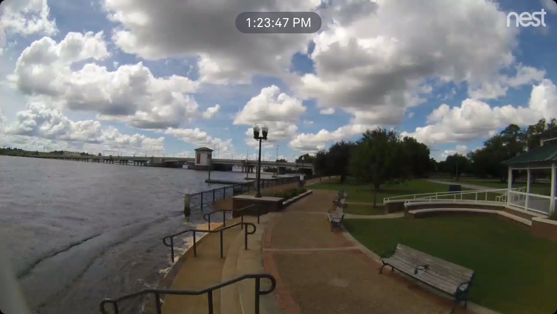
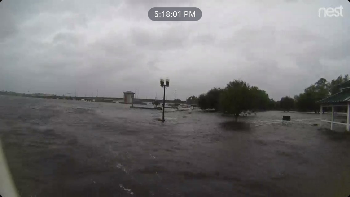
Mark Sudduth
Mark Sudduth
@hurricanetrack
·
52m
I think this speaks for itself. Union point in New Bern, North Carolina.
1 likes
Re: ATL: FLORENCE - Evacuations, Closings, Webcams, Observations
Horry SC Fire Rescue
Horry SC Fire Rescue
@hcfirerescue
We’ll be LIVE on Facebook at 7 p.m. with an update on first responders’ preparations for
#HurricaneFlorence
with Chief Tanner
Horry SC Fire Rescue
@hcfirerescue
We’ll be LIVE on Facebook at 7 p.m. with an update on first responders’ preparations for
#HurricaneFlorence
with Chief Tanner
0 likes
Re: ATL: FLORENCE - Evacuations, Closings, Webcams, Observations
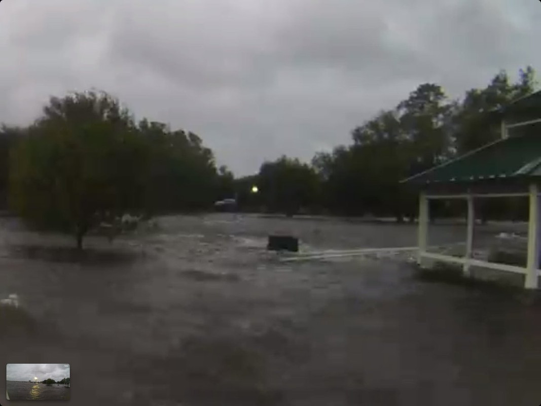
Mark Sudduth
@hurricanetrack
·
7m
That railing at the gazebo is 6 feet above ground level. I measured it 48 hours ago when I set the camera up
0 likes
Re: ATL: FLORENCE - Evacuations, Closings, Webcams, Observations
This page shows alerts currently in effect for North Carolina and is normally updated every two-three minutes. Please see here for other state and listing by county.
Last updated: 19:00 EDT on 09-13-2018
Flash Flood Watch
Issued: September 13 at 7:00PM EDT
Expiring: September 16 at 8:00PM EDT Urgency: Expected
Status: Actual
Areas affected:Alamance; Chatham; Davidson; Durham; Edgecombe; Forsyth; Franklin; Guilford; Nash; Orange; Randolph; Wake; Wilson
Flash Flood Watch
Issued: September 13 at 7:00PM EDT
Expiring: September 16 at 8:00PM EDT Urgency: Expected
Status: Actual
Areas affected:Anson; Cumberland; Harnett; Hoke; Johnston; Lee; Montgomery; Moore; Richmond; Sampson; Scotland; Stanly; Wayne
0 likes
Re: ATL: FLORENCE - Evacuations, Closings, Webcams, Observations
NCDOT Northern Coast
NCDOT Northern Coast
@NCDOT_Ncoast
·
15m
(link: http://bit.ly/2xa4oUt) bit.ly/2xa4oUt, Clarks Neck Rd, Both, North East of Grimesland, Road Obstruction , Road Closed, at 9/13 7:26 PM
NCDOT Northern Coast
NCDOT Northern Coast
@NCDOT_Ncoast
·
33m
(link: http://bit.ly/2x6s4ZW) bit.ly/2x6s4ZW, South Savannah Rd, Both, South of Belhaven, Weather Event, Road Impassable, at 9/13 7:16 PM
NCDOT Northern Coast
NCDOT Northern Coast
@NCDOT_Ncoast
·
1h
(link: http://bit.ly/2x7faLq) bit.ly/2x7faLq, Bay City Rd, Both, Near Bayboro, Weather Event, Road Closed, at 9/13 6:28 PM
NCDOT Northern Coast
NCDOT Northern Coast
@NCDOT_Ncoast
·
1h
(link: http://bit.ly/2x8L9L0) bit.ly/2x8L9L0, SR-1730, Both, East of Bath, Weather Event, Road Impassable, at 9/13 6:21 PM
NCDOT Northern Coast
@NCDOT_Ncoast
·
15m
(link: http://bit.ly/2xa4oUt) bit.ly/2xa4oUt, Clarks Neck Rd, Both, North East of Grimesland, Road Obstruction , Road Closed, at 9/13 7:26 PM
NCDOT Northern Coast
NCDOT Northern Coast
@NCDOT_Ncoast
·
33m
(link: http://bit.ly/2x6s4ZW) bit.ly/2x6s4ZW, South Savannah Rd, Both, South of Belhaven, Weather Event, Road Impassable, at 9/13 7:16 PM
NCDOT Northern Coast
NCDOT Northern Coast
@NCDOT_Ncoast
·
1h
(link: http://bit.ly/2x7faLq) bit.ly/2x7faLq, Bay City Rd, Both, Near Bayboro, Weather Event, Road Closed, at 9/13 6:28 PM
NCDOT Northern Coast
NCDOT Northern Coast
@NCDOT_Ncoast
·
1h
(link: http://bit.ly/2x8L9L0) bit.ly/2x8L9L0, SR-1730, Both, East of Bath, Weather Event, Road Impassable, at 9/13 6:21 PM
0 likes
Re: ATL: FLORENCE - Evacuations, Closings, Webcams, Observations
NCDOT Southern Coast
NCDOT Southern Coast
@NCDOT_Scoast
·
2h
(link: http://bit.ly/2OnRn0o) bit.ly/2OnRn0o, Merrimon Rd, Both, North of Beaufort, Weather Event, Lanes Narrowed, at 9/13 3:54 PM
NCDOT Southern Coast
NCDOT Southern Coast
@NCDOT_Scoast
·
3h
(link: http://bit.ly/2OipLJV) bit.ly/2OipLJV, I-40, Both, MM 364, Near Warsaw, Weather Event, Rest Area Closed, at 9/13 5:00 PM
NCDOT Southern Coast
NCDOT Southern Coast
@NCDOT_Scoast
·
3h
(link: http://bit.ly/2OnRn0o) bit.ly/2OnRn0o, Merrimon Rd, Both, North of Beaufort, Weather Event, Road Impassable, at 9/13 3:54 PM
1
NCDOT Southern Coast
NCDOT Southern Coast
@NCDOT_Scoast
·
3h
(link: http://bit.ly/2OiVxqe) bit.ly/2OiVxqe, Cedar Island Rd, Both, East of Beaufort, Weather Event, Road Impassable, at 9/13 3:50 PM
NCDOT Southern Coast
@NCDOT_Scoast
·
2h
(link: http://bit.ly/2OnRn0o) bit.ly/2OnRn0o, Merrimon Rd, Both, North of Beaufort, Weather Event, Lanes Narrowed, at 9/13 3:54 PM
NCDOT Southern Coast
NCDOT Southern Coast
@NCDOT_Scoast
·
3h
(link: http://bit.ly/2OipLJV) bit.ly/2OipLJV, I-40, Both, MM 364, Near Warsaw, Weather Event, Rest Area Closed, at 9/13 5:00 PM
NCDOT Southern Coast
NCDOT Southern Coast
@NCDOT_Scoast
·
3h
(link: http://bit.ly/2OnRn0o) bit.ly/2OnRn0o, Merrimon Rd, Both, North of Beaufort, Weather Event, Road Impassable, at 9/13 3:54 PM
1
NCDOT Southern Coast
NCDOT Southern Coast
@NCDOT_Scoast
·
3h
(link: http://bit.ly/2OiVxqe) bit.ly/2OiVxqe, Cedar Island Rd, Both, East of Beaufort, Weather Event, Road Impassable, at 9/13 3:50 PM
0 likes
Re: ATL: FLORENCE - Evacuations, Closings, Webcams, Observations
NC Emergency Managem
NC Emergency Managem
@NCEmergency
·
27m
The current power outage summary in NC is 88,098. The top counties affected are Beaufort, Carteret, Craven, New Hanover, Onslow and Pamlico. For power outage updates, visit (link: http://ow.ly/2YNg30lOw7I) ow.ly/2YNg30lOw7I .
#FlorenceNC
NC Emergency Managem
@NCEmergency
·
27m
The current power outage summary in NC is 88,098. The top counties affected are Beaufort, Carteret, Craven, New Hanover, Onslow and Pamlico. For power outage updates, visit (link: http://ow.ly/2YNg30lOw7I) ow.ly/2YNg30lOw7I .
#FlorenceNC
0 likes
Re: ATL: FLORENCE - Evacuations, Closings, Webcams, Observations
SCDOT
SCDOT
@SCDOTPress
·
45m
Happening NOW: Crews are breaking down the I-26 lane reversal. Please be cautious traveling through these lanes. SCDOT workers & troopers will be on the highways on foot breaking down lane reversals.
"Let em Work, Let em Live."
#hurricaneflorence
#letemworkletemlive
SCDOT
@SCDOTPress
·
45m
Happening NOW: Crews are breaking down the I-26 lane reversal. Please be cautious traveling through these lanes. SCDOT workers & troopers will be on the highways on foot breaking down lane reversals.
"Let em Work, Let em Live."
#hurricaneflorence
#letemworkletemlive
0 likes
-
wx247

- S2K Supporter

- Posts: 14279
- Age: 40
- Joined: Wed Feb 05, 2003 10:35 pm
- Location: Monett, Missouri
- Contact:
Re: ATL: FLORENCE - Evacuations, Closings, Webcams, Observations
WCTI in New Bern has been evacuated due to flooding according to Ginger Zee of ABC's Twitter feed.
1 likes
Personal Forecast Disclaimer:
The posts in this forum are NOT official forecast and should not be used as such. They are just the opinion of the poster and may or may not be backed by sound meteorological data. They are NOT endorsed by any professional institution or storm2k.org. For official information, please refer to the NHC and NWS products.
The posts in this forum are NOT official forecast and should not be used as such. They are just the opinion of the poster and may or may not be backed by sound meteorological data. They are NOT endorsed by any professional institution or storm2k.org. For official information, please refer to the NHC and NWS products.
Re: ATL: FLORENCE - Evacuations, Closings, Webcams, Observations
https://wgsc.beachtv.tv/m/Rgwfpm87/nort ... t=Qf0oOLHC
South Carolina beach cams
South Carolina beach cams
0 likes
Re: ATL: FLORENCE - Evacuations, Closings, Webcams, Observations
wx247 wrote:WCTI in New Bern has been evacuated due to flooding according to Ginger Zee of ABC's Twitter feed.
I’ve been hearing New Bern is being hit hard. Thank you for that update.
0 likes
-
wx247
- S2K Supporter
- Posts: 14279
- Age: 40
- Joined: Wed Feb 05, 2003 10:35 pm
- Location: Monett, Missouri
- Contact:
Re: ATL: FLORENCE - Evacuations, Closings, Webcams, Observations
artist wrote:wx247 wrote:WCTI in New Bern has been evacuated due to flooding according to Ginger Zee of ABC's Twitter feed.
I’ve been hearing New Bern is being hit hard. Thank you for that update.
Water up to the doors of the station per the latest report.
0 likes
Personal Forecast Disclaimer:
The posts in this forum are NOT official forecast and should not be used as such. They are just the opinion of the poster and may or may not be backed by sound meteorological data. They are NOT endorsed by any professional institution or storm2k.org. For official information, please refer to the NHC and NWS products.
The posts in this forum are NOT official forecast and should not be used as such. They are just the opinion of the poster and may or may not be backed by sound meteorological data. They are NOT endorsed by any professional institution or storm2k.org. For official information, please refer to the NHC and NWS products.
Re: ATL: FLORENCE - Evacuations, Closings, Webcams, Observations
NWS Newport/Morehead
NWS Newport/Morehead
@NWSMoreheadCity
·
23m
Tornado Warning continues for Havelock NC, Newport NC, Broad Creek NC until 8:15 PM EDT
NWS Newport/Morehead
@NWSMoreheadCity
·
23m
Tornado Warning continues for Havelock NC, Newport NC, Broad Creek NC until 8:15 PM EDT
0 likes
Who is online
Users browsing this forum: IsabelaWeather and 111 guests