ATL: FLORENCE - Evacuations, Closings, Webcams, Observations

This is the general tropical discussion area. Anyone can take their shot at predicting a storms path.

Moderator: S2k Moderators

Forum rules

The posts in this forum are NOT official forecasts and should not be used as such. They are just the opinion of the poster and may or may not be backed by sound meteorological data. They are NOT endorsed by any professional institution or STORM2K. For official information, please refer to products from the National Hurricane Center and National Weather Service.

Help Support Storm2K
Message
Author
User avatar
artist
Category 5
Category 5
Posts: 9793
Joined: Mon Jun 06, 2005 3:26 pm
Location: West Palm

Re: ATL: FLORENCE - Evacuations, Closings, Webcams, Observations

#21 Postby artist » Mon Sep 10, 2018 9:57 pm

NWS Charleston, SC
@NWSCharlestonSC
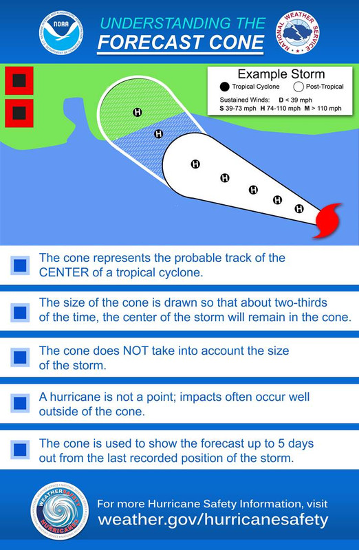
You're probably hearing a lot about "the cone". So what does that really mean? Check out this graphic about understanding the forecast cone. Remember, impacts can occur well away from the center of the storm!
#scwx

#gawx
Image
0 likes   

User avatar
Blinhart
Category 5
Category 5
Posts: 1981
Age: 47
Joined: Thu Sep 08, 2011 3:13 pm
Location: Crowley, La.

Re: ATL: FLORENCE - Evacuations, Closings, Webcams, Observations

#22 Postby Blinhart » Tue Sep 11, 2018 3:14 am

What is the threshold for the Chesapeake Bay Bridge/Tunnel to be closed?
0 likes   
Personal Forecast Disclaimer:
The posts in this forum are NOT official forecast and should not be used as such. They are just the opinion of the poster and may or may not be backed by sound meteorological data. They are NOT endorsed by any professional institution or storm2k.org. For official information, please refer to the NHC and NWS products.

User avatar
artist
Category 5
Category 5
Posts: 9793
Joined: Mon Jun 06, 2005 3:26 pm
Location: West Palm

Re: ATL: FLORENCE - Evacuations, Closings, Webcams, Observations

#23 Postby artist » Tue Sep 11, 2018 6:22 am

Blinhart wrote:What is the threshold for the Chesapeake Bay Bridge/Tunnel to be closed?


http://www.cbbt.com/travel-information/weather/
Category / Level Wind Speeds Vehicle Restrictions
Level 1 40 miles per hour The following types of vehicles will not be allowed to cross the facility during Level 1 wind restrictions: large pick-up campers; camper trailers or RVs; house trailers; anything being towed; vehicles with any exterior cargo that may become unsecured due to high winds. Complimentary District-operated wind vans will be provided to assist in transporting exterior cargo that would otherwise restrict passenger cars and pickups.

Level 2 47 miles per hour The following types of vehicles will not be allowed to cross the facility during Level 2 wind restrictions: motorcycles; large pick-up campers; camper trailers; house trailers; anything being towed; vehicles with any exterior cargo; empty tractor-trailers, not to include empty tanker trucks*; small six-wheel trucks such as moving vans, rental trucks, school buses, etc. Tractor-trailers must gross 15,000 pounds payload in addition to the weight of the rig and six-wheel trucks must gross 15,000 pounds payload in addition to the weight of the rig in order to be allowed to cross the facility during Level 2 wind restrictions. Tractors without trailers are allowed to cross. Maximum safe speed 45 mph. Complimentary District-operated wind vans will be provided to assist in transporting exterior cargo that would otherwise restrict passenger cars and pickups.
*Empty tanker trucks are allowed to cross under Level 2 wind restrictions.

Level 3 55 miles per hour The only types of vehicles allowed to cross are cars without exterior cargo; pick-up trucks without cargo; mini-vans; vans not to include high-profile/conversion vans; SUVs; tractors without trailers; empty flatbed trailers, commercial buses and heavily-laden tractor-trailers with a 30,000 payload in addition to the rig; Tanker trucks with 25,000 lb. payload in addition the rig. Maximum safe speed 45 mph. Complimentary District-operated wind vans will be provided to assist in transporting exterior cargo that would otherwise restrict passenger cars and pickups.

Level 4 60 miles per hour The only types of vehicles allowed to cross are cars without exterior cargo, pick-up trucks without cargo, mini-vans, and SUVs. Maximum safe speed 45 mph.
Complimentary District-operated wind vans will be provided to assist in transporting exterior cargo that would otherwise restrict passenger cars and pickups.

Level 5 65 miles per hour
The only types of vehicles allowed to cross are CARS without exterior cargo. Maximum safe speed 45 mph.

Level 6 CLOSED TO ALL TRAFFIC
The Chesapeake Bay Bridge-Tunnel is closed to all traffic due to unforeseen weather conditions or safety concerns. We strive to make this interruption to traffic as short as possible.

Follow. https://mobile.twitter.com/FollowTheGulls
0 likes   

User avatar
artist
Category 5
Category 5
Posts: 9793
Joined: Mon Jun 06, 2005 3:26 pm
Location: West Palm

Re: ATL: FLORENCE - Evacuations, Closings, Webcams, Observations

#24 Postby artist » Tue Sep 11, 2018 6:55 am

Anyone with info, please post here as well, so those in the areas can quickly find updated info. Thanks.
0 likes   

User avatar
artist
Category 5
Category 5
Posts: 9793
Joined: Mon Jun 06, 2005 3:26 pm
Location: West Palm

Re: ATL: FLORENCE - Evacuations, Closings, Webcams, Observations

#25 Postby artist » Tue Sep 11, 2018 7:12 am

http://apnews.com/20dd17da4e3542ae9e1cf840d8272518
The governor of Maryland has declared a state of emergency in preparation for significant flooding from Hurricane Florence.
https://www.washingtonpost.com/local/pu ... story.html
Virginia Gov. Ralph Northam (D) declared a state of emergency Saturday in anticipation of the potential impact of Tropical Storm Florence, which the National Weather Service expected to become a ...
0 likes   

User avatar
artist
Category 5
Category 5
Posts: 9793
Joined: Mon Jun 06, 2005 3:26 pm
Location: West Palm

Re: ATL: FLORENCE - Evacuations, Closings, Webcams, Observations

#26 Postby artist » Tue Sep 11, 2018 7:23 am

http://www.baltimoresun.com/news/weathe ... story.html

Know when to evacuate? Ahead of Hurricane Florence, learn Maryland's flood zones on this new map


Maryland Weather
Meteorology, astronomy and climate conditions in the Baltimore region
News Weather Maryland Weather
As Hurricane Florence targets Southeast, Gov. Hogan warns of possibly 'historic' flooding in Maryland
0 likes   

User avatar
wx247
S2K Supporter
S2K Supporter
Posts: 14279
Age: 40
Joined: Wed Feb 05, 2003 10:35 pm
Location: Monett, Missouri
Contact:

Re: ATL: FLORENCE - Evacuations, Closings, Webcams, Observations

#27 Postby wx247 » Tue Sep 11, 2018 7:46 am

Anyone know which stations in the area have livestream coverage? I have a couple of former students who I have been texting with that live in the affected area now and I would like to keep up with some local coverage, too. Thanks!
0 likes   
Personal Forecast Disclaimer:
The posts in this forum are NOT official forecast and should not be used as such. They are just the opinion of the poster and may or may not be backed by sound meteorological data. They are NOT endorsed by any professional institution or storm2k.org. For official information, please refer to the NHC and NWS products.

User avatar
artist
Category 5
Category 5
Posts: 9793
Joined: Mon Jun 06, 2005 3:26 pm
Location: West Palm

Re: ATL: FLORENCE - Evacuations, Closings, Webcams, Observations

#28 Postby artist » Tue Sep 11, 2018 7:47 am

Coastal Flood Warning

Coastal Hazard Message
National Weather Service Baltimore MD/Washington DC
450 AM EDT Tue Sep 11 2018

DCZ001-VAZ054-111700-
/O.CON.KLWX.CF.W.0011.000000T0000Z-180912T1000Z/
District of Columbia-Arlington/Falls Church/Alexandria-
450 AM EDT Tue Sep 11 2018

...COASTAL FLOOD WARNING REMAINS IN EFFECT UNTIL 6 AM EDT
WEDNESDAY...

* LOCATIONS...Shoreline in the District of Columbia and
Arlington County and the city of Alexandria.

* TIDAL DEPARTURE...2 to 4 feet above normal.

* TIMING...Flooding will occur for several hours around high tide.
The next two high tides at Washington Channel are 9:49 AM and
10:14 PM. The next two high tides at Alexandria are 10:07 AM and
10:32 PM.

* IMPACTS...The unprotected area on the Southwest Waterfront at
the DC Seafood Market is expected to flood. Water is expected to
approach parts of the Hains Point Loop Road, but it will likely
be closed. Water is expected to approach buildings near King
Street and Union Street. Water is expected to cover the
boardwalk at Washington Harbour. Shoreline inundation up to two
feet above ground is possible elsewhere. To view inundation maps
of potential flooding, visit
http://weather.gov/washington/potomacinundationmaps.

PRECAUTIONARY/PREPAREDNESS ACTIONS...

A Coastal Flood Warning means that flooding is occurring or
imminent. Coastal residents in the warned area should be alert
for rising water, and take appropriate action to protect life and
0 likes   

User avatar
artist
Category 5
Category 5
Posts: 9793
Joined: Mon Jun 06, 2005 3:26 pm
Location: West Palm

Re: ATL: FLORENCE - Evacuations, Closings, Webcams, Observations

#29 Postby artist » Tue Sep 11, 2018 7:49 am

wx247 wrote:Anyone know which stations in the area have livestream coverage? I have a couple of former students who I have been texting with that live in the affected area now and I would like to keep up with some local coverage, too. Thanks!

What area, wx247? Som will probably be sooner than others.
0 likes   

User avatar
wx247
S2K Supporter
S2K Supporter
Posts: 14279
Age: 40
Joined: Wed Feb 05, 2003 10:35 pm
Location: Monett, Missouri
Contact:

Re: ATL: FLORENCE - Evacuations, Closings, Webcams, Observations

#30 Postby wx247 » Tue Sep 11, 2018 7:50 am

artist wrote:
wx247 wrote:Anyone know which stations in the area have livestream coverage? I have a couple of former students who I have been texting with that live in the affected area now and I would like to keep up with some local coverage, too. Thanks!

What area, wx247? Som will probably be sooner than others.

The Wilmington area... one lives a bit NE of there, but I assume that is the media market.
0 likes   
Personal Forecast Disclaimer:
The posts in this forum are NOT official forecast and should not be used as such. They are just the opinion of the poster and may or may not be backed by sound meteorological data. They are NOT endorsed by any professional institution or storm2k.org. For official information, please refer to the NHC and NWS products.

User avatar
artist
Category 5
Category 5
Posts: 9793
Joined: Mon Jun 06, 2005 3:26 pm
Location: West Palm

Re: ATL: FLORENCE - Evacuations, Closings, Webcams, Observations

#31 Postby artist » Tue Sep 11, 2018 7:54 am

wx247 wrote:
artist wrote:
wx247 wrote:Anyone know which stations in the area have livestream coverage? I have a couple of former students who I have been texting with that live in the affected area now and I would like to keep up with some local coverage, too. Thanks!

What area, wx247? Som will probably be sooner than others.

The Wilmington area... one lives a bit NE of there, but I assume that is the media market.

wect.com I will assume will go live as Florence gets closer.
Also try. https://www.wwaytv3.com/
Last edited by artist on Tue Sep 11, 2018 7:58 am, edited 1 time in total.
0 likes   

User avatar
artist
Category 5
Category 5
Posts: 9793
Joined: Mon Jun 06, 2005 3:26 pm
Location: West Palm

Re: ATL: FLORENCE - Evacuations, Closings, Webcams, Observations

#32 Postby artist » Tue Sep 11, 2018 7:55 am

BP stations in Wilmington are reporting that the stores are running low on fuel. (Source: WECT
Gas stations in Wilmington are running out of gas as Hurricane Florence approaches. (Source: WECT

WILMINGTON, NC (WECT) -
As of 4 p.m. Monday, the BP gas station at 3706 Shipyard Boulevard was out of gas. Store employees say a truck is expected in around 7 p.m. but they anticipate that fuel will go quickly, too.

The BP station at 1301 Military Cutoff reported a critical fuel shortage as well due to Hurricane Florence.

“We are almost out of premium and regular but we’re expecting a truck in just a couple hours,” said Nadine Schrock, assistant store manager.

Residents are encouraged to fill their gas tanks as Hurricane Florence continues to threaten the Carolinas as a Category 4 storm.

WECT will continue to monitor the gas supply with updates on wect.com and the WECT mobile app.

Fill up your vehicles and gas cans now!
0 likes   

User avatar
Tireman4
S2K Supporter
S2K Supporter
Posts: 5674
Age: 58
Joined: Fri Jun 30, 2006 1:08 pm
Location: Humble, Texas
Contact:

Re: ATL: FLORENCE - Evacuations, Closings, Webcams, Observations

#33 Postby Tireman4 » Tue Sep 11, 2018 8:34 am

N.C. Central Univ.

Verified account

@NCCU
33m33 minutes ago
More
#EagleAlert: #NCCU residence halls will remain open for students who live on campus and are not able to travel home. Beginning at 5 p.m. today, students who reside on campus, have completed their Tuesday classes and wish to travel home are encouraged to do so.
1 likes   

User avatar
artist
Category 5
Category 5
Posts: 9793
Joined: Mon Jun 06, 2005 3:26 pm
Location: West Palm

Re: ATL: FLORENCE - Evacuations, Closings, Webcams, Observations

#34 Postby artist » Tue Sep 11, 2018 8:40 am

MANDATORY EVACUATION ISSUED FOR CAROLINA BEACH RESIDENTS
By WWAY News - September 10, 2018 6:28 PM0

LELAND ISSUES EVACUATIONS, TOWN-WIDE CURFEW DUE TO FLORENCE
September 10, 2018 12:46 PM
video
BRUNSWICK COUNTY ISSUES EVACUATIONS; SHELTERS TO OPEN INLAND
September 10, 2018 11:53 AM
video
AREA SCHOOLS TO CLOSE DUE TO HURRICANE FLORENCE
September 10, 2018 4:28 PM
video
SOUTHPORT ISSUES MANDATORY EVACUATIONS


WILMINGTON, NC (WWAY) — With Hurricane Florence approaching the East Coast, many shelters across the southeast are starting to open.

PENDER COUNTY

Starting Tuesday, Pender County, in cooperation with the American Red Cross and Pender County Health Department, Pender County Schools, and the Pender County Sheriff’s Department, four shelters will be activated.

Burgaw Middle School, pet-friendly shelter
Topsail Elementary School
Cape Fear Middle School
Malpass Corner Elementary
Burgaw Middle will open Tuesday at 4 p.m. The remaining shelters will open Wednesday at 8 a.m.

If you need assistance in Pender County, call the Emergency Management office at (910) 259-1210.

Related Article: Brunswick County issues evacuations; shelters to open inland
NEW HANOVER COUNTY

The first New Hanover County evacuation shelter will open Tuesday at 7 p.m.

Trask Middle School, a pet-friendly shelter and cats and dogs are welcome (no exotic animals), and limited food service will be available for people seeking shelter.
The following public shelters may also be opened for the storm, but they have not been scheduled to open at this time:

Johnson Pre-K Center
Codington Elementary School
Eaton Elementary School
New Hanover County officials say those seeking emergency shelter should bring their own blankets/pillows, prescription medications and other necessary items.

No alcohol, illegal drugs, or weapons are permitted. Pet owners should bring their dog or cat in crates, along with pet food.

Anyone with questions about evacuating or shelter openings can call the public information hotline telephone number beginning at noon Tuesday at (910) 798-6800.

BRUNSWICK COUNTY

Brunswick County recommends residents seek shelters outside of Brunswick County, but they will open the following shelters for those who can’t leave.

West Brunswick High School, pet-friendly
North Brunswick High School
South Brunswick High School
West Brunswick High is opening Tuesday at 2 p.m. The other two shelters will open at 8 a.m. on Wednesday.

If you bring pets, the owners must stay at the shelter as well, and should bring documentation of rabies vaccines, food, any medicines, and any other items necessary for your pets.

BLADEN COUNTY

Bladen County will open the following shelters starting at noon on Wednesday.

East Bladen High School
West Bladen High School, pet-friendly
Bladen Lakes Elementary School
East Arcadia Elementary School
BARTS will be available for transportation to the shelters beginning at 8:30 p.m. Wednesday. Call them at (910) 862-6930. Call early, they will not be available after winds reach a sustained 25 miles/hour.

If you have special needs, such as oxygen dependent, you are encouraged to go to West Bladen High.

https://www.wwaytv3.com/2018/09/10/shel ... -of-storm/
0 likes   

User avatar
artist
Category 5
Category 5
Posts: 9793
Joined: Mon Jun 06, 2005 3:26 pm
Location: West Palm

Re: ATL: FLORENCE - Evacuations, Closings, Webcams, Observations

#35 Postby artist » Tue Sep 11, 2018 8:42 am

Please periodically check post #1 for updates for live streams, etc.
0 likes   

User avatar
artist
Category 5
Category 5
Posts: 9793
Joined: Mon Jun 06, 2005 3:26 pm
Location: West Palm

Re: ATL: FLORENCE - Evacuations, Closings, Webcams, Observations

#36 Postby artist » Tue Sep 11, 2018 9:32 am

Hurricane Local Statement

Hurricane Florence Local Statement Intermediate Advisory Number 48A
NCZ087-096-099-105>110-SCZ054>056-058-059-112030-

Hurricane Florence Local Statement Intermediate Advisory Number 48A
National Weather Service Wilmington NC AL062018
825 AM EDT Tue Sep 11 2018

This product covers SOUTHEAST NORTH CAROLINA AND NORTHEAST SOUTH CAROLINA

** Major Hurricane Florence Approaching the Southeast Coast **

NEW INFORMATION
---------------

* CHANGES TO WATCHES AND WARNINGS:
- A Storm Surge Watch and Hurricane Watch have been issued for
Central Horry, Coastal Brunswick, Coastal Georgetown, Coastal
Horry, Coastal New Hanover, Coastal Pender, Inland Brunswick,
Inland Georgetown, and Inland New Hanover
- A Hurricane Watch has been issued for Bladen, Columbus, Inland
Pender, Northern Horry, and Robeson

* CURRENT WATCHES AND WARNINGS:
- A Storm Surge Watch and Hurricane Watch are in effect for
Central Horry, Coastal Brunswick, Coastal Georgetown, Coastal
Horry, Coastal New Hanover, Coastal Pender, Inland Brunswick,
Inland Georgetown, and Inland New Hanover
- A Hurricane Watch is in effect for Bladen, Columbus, Inland
Pender, Northern Horry, and Robeson

* STORM INFORMATION:
- About 950 miles east-southeast of Wilmington NC or about 990
miles east-southeast of Myrtle Beach SC
- 26.4N 64.6W
- Storm Intensity 130 mph
- Movement West-northwest or 290 degrees at 15 mph

SITUATION OVERVIEW
------------------

Hurricane Florence continues to approach the Southeast coast as a major
category 4 hurricane. While the exact track of Florence remains
uncertain, the likelihood of of life-threatening storm surge inundation,
damaging winds and excessive rainfall across southeast North Carolina and
northeast South Carolina continues to increase. Life-threatening conditions
will also continue in the surf zone on area beaches. The worst
conditions are expected Thursday into Friday.

POTENTIAL IMPACTS
-----------------

* WIND:
Prepare for life-threatening wind having possible devastating impacts
across southeastern North Carolina.
Potential impacts in this area include:
- Structural damage can be expected to sturdy buildings, with
some suffering severe or total destruction. Complete
destruction of mobile homes and other poorly constructed
buildings is likely. Damage greatly enhanced by large
projectiles. Locations may be uninhabitable for a significant
period of time.
- Numerous large trees may be snapped or uprooted, along with
fences and roadway signs gone.
- Many roads will become unsafe and impassable from large debris.
Many bridges, causeways, and other elevated roadways will
become impassable.
- Extensive power and communications outages can be expected.
- Many vessels will break free from their moorings.

Also, prepare for life-threatening wind having possible significant
to extensive impacts across northeastern South Carolina.

* SURGE:
Prepare for life-threatening surge having possible devastating
impacts across low lying areas of southeastern North Carolina.
Potential impacts in this area include:
- Dangerous widespread and deep storm surge inundation. The surge
will affect homes close to tidal creeks and waterways farther
inland than what people are accustomed to. The surge combined
with battering waves will damage many homes along the barrier
islands. Structural damage to buildings is likely in many areas
as a result, with many on the barrier islands washing away. The
damage will be greatly compounded from a considerable amount of
floating debris. Locations may become uninhabitable for an
extended period.
- Delivery of drinking water and sewer services may be lost in
coastal communities. Surge waters will contain hazardous
materials.
- Coastal roads will become severely flooded and may be washed
out completely.
- Extreme beach erosion with significant loss of dunes and the
potential for new inlets carved into some of the barrier
islands. A large amount of sand will be deposited onto the
barrier islands blocking roadways.Massive damage to marinas,
docks, boardwalks, and piers is expected. Small craft will
break away from moorings with many lifted onshore and stranded
inland.Navigation will be difficult, especially near inlets and
waterways, as navigational aids may be off station or missing.
Debris in waterways and other navigable channels will make
navigation hazardous.

Also, prepare for life-threatening surge having possible significant
to extensive impacts across parts of southeastern North Carolina.

Also, prepare for locally hazardous surge having possible limited
impacts across northeastern South Carolina.


* FLOODING RAIN:
Prepare for dangerous rainfall flooding having possible significant
impacts across southeastern North Carolina. Potential impacts
include:
- Moderate flooding from rainfall may prompt some evacuations and
rescues.
- Rivers and streams may rise and overspill their banks in a few
places, especially in the typical prone locations. Small creeks
and ditches may overflow.
- Flood waters may enter some structures. Underpasses, low-lying
spots along roadways, and poor drainage areas may become
submerged by rising water. Some secondary streets and parking
lots may flood as storm drains and retention ponds overflow.
- Driving conditions will become hazardous, and some road
closures can be expected.

Prepare for locally hazardous rainfall flooding having possible
limited impacts across northeastern South Carolina.

* TORNADOES:
Prepare for a tornado event having possible limited impacts across
southeastern North Carolina. Potential impacts include:
- The occurrence of isolated tornadoes can hinder the execution
of emergency plans during tropical events.
- A few places may experience tornado damage, along with power
and communications disruptions.
- Tornadoes can cause damage to trees, vehicles, boats, and
buildings. Unsecured mobile homes and poorly constructed
structures are particularly vulnerable.
0 likes   

User avatar
Blinhart
Category 5
Category 5
Posts: 1981
Age: 47
Joined: Thu Sep 08, 2011 3:13 pm
Location: Crowley, La.

Re: ATL: FLORENCE - Evacuations, Closings, Webcams, Observations

#37 Postby Blinhart » Tue Sep 11, 2018 9:32 am

artist wrote:
Blinhart wrote:What is the threshold for the Chesapeake Bay Bridge/Tunnel to be closed?


http://www.cbbt.com/travel-information/weather/
Category / Level Wind Speeds Vehicle Restrictions
Level 1 40 miles per hour The following types of vehicles will not be allowed to cross the facility during Level 1 wind restrictions: large pick-up campers; camper trailers or RVs; house trailers; anything being towed; vehicles with any exterior cargo that may become unsecured due to high winds. Complimentary District-operated wind vans will be provided to assist in transporting exterior cargo that would otherwise restrict passenger cars and pickups.

Level 2 47 miles per hour The following types of vehicles will not be allowed to cross the facility during Level 2 wind restrictions: motorcycles; large pick-up campers; camper trailers; house trailers; anything being towed; vehicles with any exterior cargo; empty tractor-trailers, not to include empty tanker trucks*; small six-wheel trucks such as moving vans, rental trucks, school buses, etc. Tractor-trailers must gross 15,000 pounds payload in addition to the weight of the rig and six-wheel trucks must gross 15,000 pounds payload in addition to the weight of the rig in order to be allowed to cross the facility during Level 2 wind restrictions. Tractors without trailers are allowed to cross. Maximum safe speed 45 mph. Complimentary District-operated wind vans will be provided to assist in transporting exterior cargo that would otherwise restrict passenger cars and pickups.
*Empty tanker trucks are allowed to cross under Level 2 wind restrictions.

Level 3 55 miles per hour The only types of vehicles allowed to cross are cars without exterior cargo; pick-up trucks without cargo; mini-vans; vans not to include high-profile/conversion vans; SUVs; tractors without trailers; empty flatbed trailers, commercial buses and heavily-laden tractor-trailers with a 30,000 payload in addition to the rig; Tanker trucks with 25,000 lb. payload in addition the rig. Maximum safe speed 45 mph. Complimentary District-operated wind vans will be provided to assist in transporting exterior cargo that would otherwise restrict passenger cars and pickups.

Level 4 60 miles per hour The only types of vehicles allowed to cross are cars without exterior cargo, pick-up trucks without cargo, mini-vans, and SUVs. Maximum safe speed 45 mph.
Complimentary District-operated wind vans will be provided to assist in transporting exterior cargo that would otherwise restrict passenger cars and pickups.

Level 5 65 miles per hour
The only types of vehicles allowed to cross are CARS without exterior cargo. Maximum safe speed 45 mph.

Level 6 CLOSED TO ALL TRAFFIC
The Chesapeake Bay Bridge-Tunnel is closed to all traffic due to unforeseen weather conditions or safety concerns. We strive to make this interruption to traffic as short as possible.

Follow. https://mobile.twitter.com/FollowTheGulls


Thank you, that is for wind, I was actually wondering about for sea level rises.
0 likes   
Personal Forecast Disclaimer:
The posts in this forum are NOT official forecast and should not be used as such. They are just the opinion of the poster and may or may not be backed by sound meteorological data. They are NOT endorsed by any professional institution or storm2k.org. For official information, please refer to the NHC and NWS products.

User avatar
artist
Category 5
Category 5
Posts: 9793
Joined: Mon Jun 06, 2005 3:26 pm
Location: West Palm

Re: ATL: FLORENCE - Evacuations, Closings, Webcams, Observations

#38 Postby artist » Tue Sep 11, 2018 9:35 am

Hazardous Weather Outlook

Hazardous Weather Outlook
National Weather Service Wakefield VA
611 AM EDT Tue Sep 11 2018

MDZ025-VAZ098>100-121015-
Maryland Beaches-Virginia Beach-Accomack-Northampton-
611 AM EDT Tue Sep 11 2018

...HIGH RIP CURRENT RISK IN EFFECT THROUGH THIS EVENING...

This Hazardous Weather Outlook is for southeast Maryland, eastern
Virginia and southeast Virginia.

.DAY ONE...Today and tonight.

Please listen to NOAA Weather Radio or go to weather.gov on the
Internet for more information about the following hazards.

High Rip Current Risk.

.DAYS TWO THROUGH SEVEN...Wednesday through Monday.

The risk of significant impacts from Hurricane Florence is
increasing. While there is still quite a bit of uncertainty
regarding the exact track and speed, the potential for strong winds
and prolonged extremely heavy rainfall is growing.

Please continue to closely monitor the latest forecasts on Hurricane
Florence. Take time now to put together emergency kits and put a
plan in place for your family and pets.

.SPOTTER INFORMATION STATEMENT...

Spotter activation is not expected at this time.

$$


Minor flooding is already occurring.
0 likes   

User avatar
artist
Category 5
Category 5
Posts: 9793
Joined: Mon Jun 06, 2005 3:26 pm
Location: West Palm

Re: ATL: FLORENCE - Evacuations, Closings, Webcams, Observations

#39 Postby artist » Tue Sep 11, 2018 9:36 am

Hazardous Weather Outlook
National Weather Service Baltimore MD/Washington DC
530 AM EDT Tue Sep 11 2018

ANZ530>543-DCZ001-MDZ011-013-014-016>018-508-VAZ052>057-120930-
Chesapeake Bay north of Pooles Island MD-
Chesapeake Bay from Pooles Island to Sandy Point MD-
Chesapeake Bay from Sandy Point to North Beach MD-
Chesapeake Bay from North Beach to Drum Point MD-
Chesapeake Bay from Drum Point MD to Smith Point VA-
Tidal Potomac from Key Bridge to Indian Head MD-
Tidal Potomac from Indian Head to Cobb Island MD-
Tidal Potomac from Cobb Island MD to Smith Point VA-
Patapsco River including Baltimore Harbor-
Chester River to Queenstown MD-Eastern Bay-
Choptank River to Cambridge MD and the Little Choptank River-
Patuxent River to Broomes Island MD-
Tangier Sound and the inland waters surrounding Bloodsworth
Island-District of Columbia-Southern Baltimore-Prince Georges-
Anne Arundel-Charles-St. Marys-Calvert-Southeast Harford-
Prince William/Manassas/Manassas Park-Fairfax-
Arlington/Falls Church/Alexandria-Stafford-Spotsylvania-
King George-
530 AM EDT Tue Sep 11 2018

This Hazardous Weather Outlook is for the Maryland portion of the
Chesapeake Bay, Tidal Potomac River, and adjacent counties in
central Maryland and northern Virginia as well as the District of
Columbia.

.DAY ONE...Today and Tonight

A Dense Fog Advisory is in effect for portions of the Baltimore-
Washington metropolitan area until 10 AM this morning.

A Coastal Flood Warning remains in effect for Anne Arundel County,
Washington DC and the city of Alexandria through tonight. For
Saint Marys County, a Coastal Flood Warning is in effect today,
and a Coastal Flood Watch is in effect tonight.

Consult the latest River Flood Warnings for further information
on flooding along the Potomac River.

.DAYS TWO THROUGH SEVEN...Wednesday through Monday

Fresh water on the Potomac combined with higher than normal tides
may lead to additional moderate coastal flooding in Washington DC
on Wednesday.

Please consult the latest River Flood Warnings for the latest
information regarding flooding on the Potomac River.

Consult the latest guidance and information from the National
Hurricane Center concerning the possible effects of Hurricane
Florence.
0 likes   

User avatar
artist
Category 5
Category 5
Posts: 9793
Joined: Mon Jun 06, 2005 3:26 pm
Location: West Palm

Re: ATL: FLORENCE - Evacuations, Closings, Webcams, Observations

#40 Postby artist » Tue Sep 11, 2018 9:38 am

0 likes   


Return to “Talkin' Tropics”

Who is online

Users browsing this forum: lilbump3000, NotSparta and 92 guests