Do you think Michael will be upgraded to Category 5?
Moderator: S2k Moderators
Forum rules

The posts in this forum are NOT official forecasts and should not be used as such. They are just the opinion of the poster and may or may not be backed by sound meteorological data. They are NOT endorsed by any professional institution or STORM2K. For official information, please refer to products from the National Hurricane Center and National Weather Service.


-
toad strangler

- S2K Supporter

- Posts: 4162
- Joined: Sun Jul 28, 2013 3:09 pm
- Location: Earth
- Contact:
Re: Do you think Michael will be upgraded to Category 5?
Re analysis and damage assessment will be very interesting in this regard. So, yes I’d say there is a decent chance.
0 likes
-
Hurricane Andrew

- S2K Supporter
- Posts: 1891
- Age: 25
- Joined: Sun May 23, 2010 2:53 pm
- Location: KS
Re: Do you think Michael will be upgraded to Category 5?
My guess is no. I'm sure there were Category 5 gusts, maybe as high as 170mph, but sustained winds seemed to be in the Category 4 range. Then again; I'm not on the ground. I've only seen pictures, and damage seems to line up with Category 4, rather than Category 5 -type damage. The one exception to this is the tree damage...might be a gust thing. Who knows.
The NHC will decide.
The NHC will decide.
1 likes
The Enthusiast
NREMT-AEMT, WX nerd
Irene '11, Sandy '12, Irma '17 (SAR)
"Hard to think we were born to live this way..." -Wage War

Re: Do you think Michael will be upgraded to Category 5?
THere's probably at least a 50/50 chance of an upgrade. It'll go in my books as such if nothing else.
3 likes
The above post is not official and should not be used as such. It is the opinion of the poster and may or may not be backed by sound meteorological data. It is not endorsed by any professional institution or storm2k.org. For official information, please refer to the NHC and NWS products.
-
Hypercane_Kyle

- Category 5

- Posts: 2899
- Joined: Sat Mar 07, 2015 7:58 pm
- Location: Cape Canaveral, FL
Re: Do you think Michael will be upgraded to Category 5?
I think it'll be upped to ~165mph based on damage on the ground and FL winds from recon.
0 likes
My posts are my own personal opinion, defer to the National Hurricane Center (NHC) and other NOAA products for decision making during hurricane season.

Re: Do you think Michael will be upgraded to Category 5?
Absolutely without a doubt.
0 likes
blonde stacey (xe/xem/xir)

Re: Do you think Michael will be upgraded to Category 5?
Snapping of pine trees is very widespread and severe. Most structures in the hardest hit areas (Mexico Beach, Tyndall AFB) have severe damage. It's more intense than Charley for sure, but maybe not quite as bad as Andrew. However looking at Maria @ PR landfall, which had the same intensity as Michael (operationally), Michael seemed to do more wind damage at the coast. The eyewall footage from Michael also does seem to be more intense than Maria. Most notably Sudduth's cam in Mexico Beach, which had whiteout conditions so intense you could see pretty much nothing within a foot or so of the camera.
I'd say this alone is supportive of an intensity stronger than Maria (so, 140kt). Radar velocities were also around 170kt, which does translate to 138kt or so accounting for beam height. I think KZC worked out to ~138kt as well. Overall, it's gonna be a close call for the NHC to make, but it seems to be slightly weighted to the cat 5 side. It goes down as a cat 5 in my book either way.
EDIT: Oh, and there was the report of 150mph sustained at Tyndall. If there's any data backing this it'll make the upgrade an easy decision for the NHC.
4 likes
Kendall -> SLO -> PBC
Memorable Storms: Katrina (for its Florida landfall...) Wilma Matthew Irma
Memorable Storms: Katrina (for its Florida landfall...) Wilma Matthew Irma

Re: Do you think Michael will be upgraded to Category 5?
I'd give it about a 30% chance. There's a lot of reports, images, and video from storm chasers of the eyewall as well as the damage afterwards which could possibly aid in an upgrade, but what I'm curious about is if there was a Doppler-on-wheels (DOW) deployed to study the eyewall. I know one was deployed in Harvey last year because I read the article regarding their findings from that mission, and I posted it in the intense tropical cyclones thread if anyone is interested in reading it. I believe I also read somewhere that they did a DOW mission into Irma as well, but I've yet to find any literature discussing findings from that mission.
For Harvey, they tracked some TSVs (tornado-scale vortices) and it seemed that they were responsible for the most extreme wind damage during Harvey.
I think TSVs might have been heavily prominent during Michael which would account for the heavy wind damage, especially the crazy tree damage we've been seeing pictures of. I'd quite like to know if they did conduct a DOW mission for Michael, because they could have quite possibly gathered data that supports Cat 5.
It will also been interesting to see what other measurements were made by land stations as they continue gathering data. I'm looking forward to reading the TCR for Michael in a few months.
2 likes
Solar Aquarian
Lunar Cancerian
 Sagittarian
Lunar Cancerian
-
Sciencerocks
- Category 5
- Posts: 7286
- Age: 38
- Joined: Thu Jul 06, 2017 1:51 am
Re: Do you think Michael will be upgraded to Category 5?
152 knot flight level winds, 190+ radar winds at 8,000 feet and the damage. I'd say no question it'll be upgraded.
3 likes
-
supercane4867
- Category 5
- Posts: 4966
- Joined: Wed Nov 14, 2012 10:43 am
Re: Do you think Michael will be upgraded to Category 5?
Had Michael existed 10 years ago, the 152kt flight level wind alone would justify an upgrade. The most recent borderline CAT4/5 cases, Joaquin and Jose, didn't get upgrade since the converted FL->SFC winds were much lower than SFMR measured surface winds. The max 700mb FL winds for Joaquin and Jose were 144kt and 146kt, which both correspond to about 130kt at surface using standard 0.9 reduction factor. I'd say a blend of FL wind, ADT estimate and radar velocity data maybe just enough for Michael to be bumped to 140kt.
1 likes
-
SconnieCane
- Category 4

- Posts: 913
- Joined: Thu Aug 02, 2018 5:29 pm
- Location: Madison, WI
Re: Do you think Michael will be upgraded to Category 5?
I wonder if Michael's slightly unusual convective structure at time of landfall might work against the possibility of an upgrade. It was apparent from radar that the strongest convection had rotated around to the western side of the eyewall. This might have "balanced out" the strongest winds in the eyewall to an extent, so the right front eyewall was slightly weaker than normal and the left front slightly stronger. This would have exacerbated the damage in Callaway/Panama City, while not really being a saving grace for Mexico Beach but possibly reducing the maximum winds by 5-10kt from what they would have been had equally strong convection been located in the right front quadrant.
1 likes
Re: Do you think Michael will be upgraded to Category 5?
SconnieCane wrote:I wonder if Michael's slightly unusual convective structure at time of landfall might work against the possibility of an upgrade. It was apparent from radar that the strongest convection had rotated around to the western side of the eyewall. This might have "balanced out" the strongest winds in the eyewall to an extent, so the right front eyewall was slightly weaker than normal and the left front slightly stronger. This would have exacerbated the damage in Callaway/Panama City, while not really being a saving grace for Mexico Beach but possibly reducing the maximum winds by 5-10kt from what they would have been had equally strong convection been located in the right front quadrant.
I don't know if that's the case, the max flight level winds of 152kt were observed in a recon pass into the SE quad right as the storm was landfalling and had this structure. The structure wasn't exactly as evident as one may believe, and I highly doubt it persisted long enough to cause any weakening
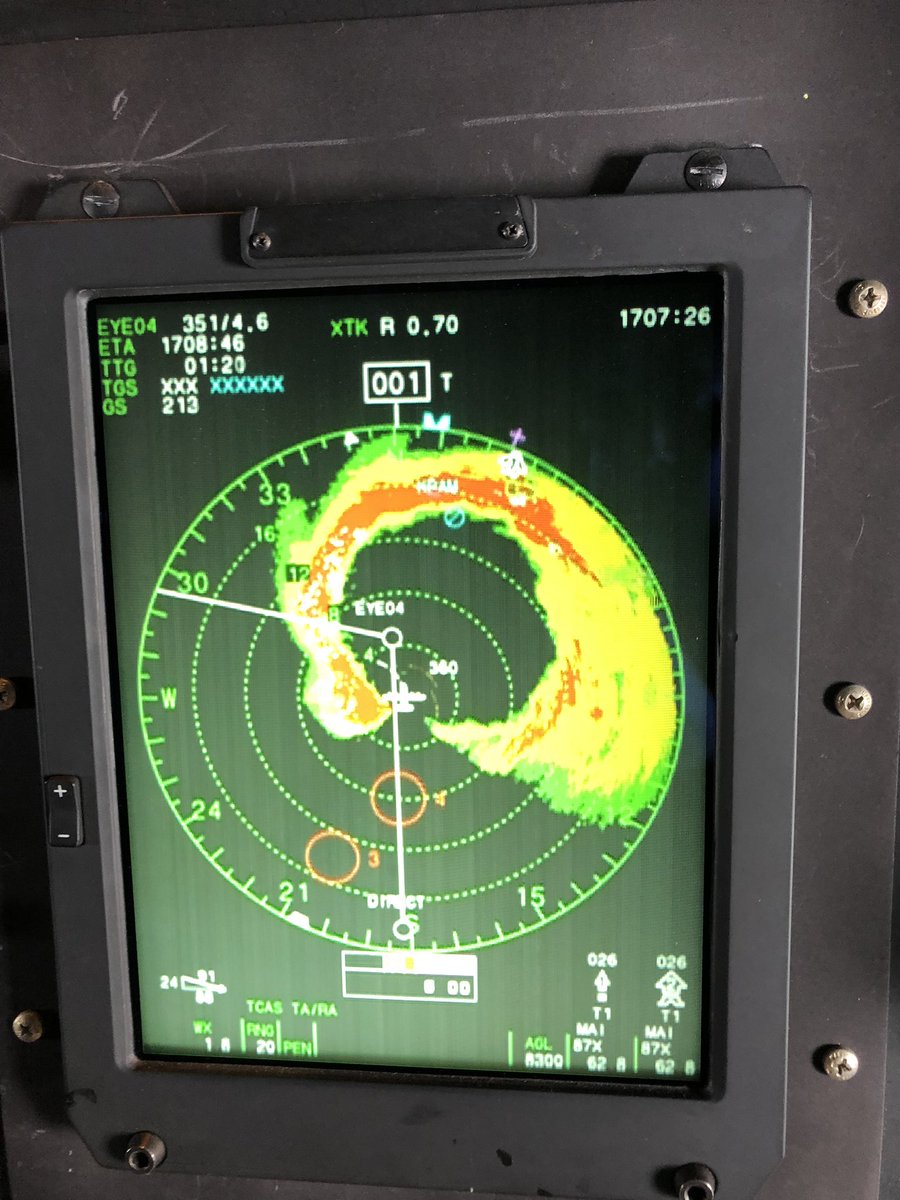
note: the slight perturbation on the S side is not the storm's structure in this image, just a symptom of how the plane's radar is positioned/works
Last edited by Ubuntwo on Sat Oct 13, 2018 7:38 pm, edited 1 time in total.
0 likes
Kendall -> SLO -> PBC
Memorable Storms: Katrina (for its Florida landfall...) Wilma Matthew Irma
Memorable Storms: Katrina (for its Florida landfall...) Wilma Matthew Irma
-
supercane4867
- Category 5
- Posts: 4966
- Joined: Wed Nov 14, 2012 10:43 am
Re: Do you think Michael will be upgraded to Category 5?
SconnieCane wrote:I wonder if Michael's slightly unusual convective structure at time of landfall might work against the possibility of an upgrade. It was apparent from radar that the strongest convection had rotated around to the western side of the eyewall. This might have "balanced out" the strongest winds in the eyewall to an extent, so the right front eyewall was slightly weaker than normal and the left front slightly stronger. This would have exacerbated the damage in Callaway/Panama City, while not really being a saving grace for Mexico Beach but possibly reducing the maximum winds by 5-10kt from what they would have been had equally strong convection been located in the right front quadrant.
Radar reflectivity only measures the intensity of precipitation, not the wind beneath it. Recon data have been consistently indicating the strongest winds were transitioning from NE to the SE portion of the eyewall. While the area of higher reflectivity may had some intense gusts associated with mesoscale activity, by no means the highest sustained winds were not in the SE side.
1 likes
-
terstorm1012

- S2K Supporter
- Posts: 1313
- Age: 42
- Joined: Fri Sep 10, 2004 5:36 pm
- Location: Millersburg, PA
Re: Do you think Michael will be upgraded to Category 5?
I'd say the evidence is certainly there for an upgrade, although we'll have to wait until the assessments are all done.
0 likes
-
wxmann_91

- Category 5
- Posts: 8013
- Age: 32
- Joined: Fri Jul 15, 2005 2:49 pm
- Location: Southern California
- Contact:
Re: Do you think Michael will be upgraded to Category 5?
SconnieCane wrote:I wonder if Michael's slightly unusual convective structure at time of landfall might work against the possibility of an upgrade. It was apparent from radar that the strongest convection had rotated around to the western side of the eyewall. This might have "balanced out" the strongest winds in the eyewall to an extent, so the right front eyewall was slightly weaker than normal and the left front slightly stronger. This would have exacerbated the damage in Callaway/Panama City, while not really being a saving grace for Mexico Beach but possibly reducing the maximum winds by 5-10kt from what they would have been had equally strong convection been located in the right front quadrant.
It is actually not unusual for the western eyewall to have higher rain rates/reflectivities during landfall (Kimball 2007 features a numerical simulation that shows this).
Harvey, Dennis 05, Charley, heck even Florence demonstrated this behavior at landfall.
Last edited by wxmann_91 on Sat Oct 13, 2018 9:15 pm, edited 1 time in total.
3 likes
-
CrazyC83
- Professional-Met

- Posts: 33393
- Joined: Tue Mar 07, 2006 11:57 pm
- Location: Deep South, for the first time!
Re: Do you think Michael will be upgraded to Category 5?
There are 4 key factors working FOR an upgrade:
* Flight level winds of 152 kt in the SE quad. That equates to 137 kt at the surface using standard ratios. Plus the RFQ - and the convectively active NW quad - were both on land at the time, so it might have been even higher.
* Doppler velocities at about 5,000 feet were as high as 171 kt, which translates to 137 kt at the surface over water.
* SFMR readings were 138 kt at the time of landfall, but that comes with shallow water caveats so I'd be cautious on that one.
* The KZC estimate for the landfall pressure was between 139 and 142 kt, and it seemed to fit very nicely with Michael's pressure through most of its lifespan.
Also, was the 130 kt estimate at Tyndall AFB an actual measurement? That would be another factor working towards an upgrade. A combination of all that data seems to support a landfall intensity of 140 kt. If it was only the SFMR supporting an upgrade, I would not upgrade it due to shoaling issues and uncertainty, but there seems to be enough data to support it.
7 likes

Re: Do you think Michael will be upgraded to Category 5?
Here are some interesting stats regarding that measured 150 kt (30-second) and 152 kt (10-second) flight level wind. As far as I know, there has never been a recon flight which found 30-second 700 mb winds of 150 kt or more in a Category 4 hurricane since at least 1989 (start of the Tropical Atlantic recon archive). They have all been analysed as Cat 5's at the time of measurement. In fact, that 150 kt value is above the upper quartile of measurements in 140 kt Cat 5's. The quick-and-dirty graphics below also include WPAC, EPAC, weakening and/or EWRC-ing storms...

The non-Cat 5 storms closest to Michael in terms of 30-second flight level winds are Emily '05 (149 kt flight level, 135 kt best track at Jul. 16, 18z), Ivan '04 (149 kt flight level, 125 kt best track at Sep. 10, 06z) and Mitch '98 (149 kt flight level, 125 kt best track at Oct. 25, 18z).
Here is the same graphic but with 10-second flight level winds which tells a similar story:

The only 135 kt storm in this data set with higher measured 10-second flight level winds than Michael has been Hugo '89 (162 kt flight level, 135 kt best track at Sep. 16, 00z).
However, there have been two occasions where a 152 kt or higher 10-second flight level wind has been measured in a storm weaker than 135 kt: Mitch '98 (155 kt flight level, 125 kt best track at Oct. 25, 18z) and Opal '95 (152 kt flight level, 130 kt best track at Oct. 4, 12z).
Below is an overview graphic showing all recon flights since 1989 which found 30-second/10-second flight level winds of 130 kt or higher and the respective best track values:

Although these quick-and-dirty graphics strongly suggest an upgrade of Michael to Cat 5 would be justified by the observed flight level winds, I also think it is quite obvious that the estimated best track intensity often depends on other data than just flight level winds. But it is nevertheless interesting to compare...
The non-Cat 5 storms closest to Michael in terms of 30-second flight level winds are Emily '05 (149 kt flight level, 135 kt best track at Jul. 16, 18z), Ivan '04 (149 kt flight level, 125 kt best track at Sep. 10, 06z) and Mitch '98 (149 kt flight level, 125 kt best track at Oct. 25, 18z).
Here is the same graphic but with 10-second flight level winds which tells a similar story:
The only 135 kt storm in this data set with higher measured 10-second flight level winds than Michael has been Hugo '89 (162 kt flight level, 135 kt best track at Sep. 16, 00z).
However, there have been two occasions where a 152 kt or higher 10-second flight level wind has been measured in a storm weaker than 135 kt: Mitch '98 (155 kt flight level, 125 kt best track at Oct. 25, 18z) and Opal '95 (152 kt flight level, 130 kt best track at Oct. 4, 12z).
Below is an overview graphic showing all recon flights since 1989 which found 30-second/10-second flight level winds of 130 kt or higher and the respective best track values:
Although these quick-and-dirty graphics strongly suggest an upgrade of Michael to Cat 5 would be justified by the observed flight level winds, I also think it is quite obvious that the estimated best track intensity often depends on other data than just flight level winds. But it is nevertheless interesting to compare...
11 likes

Who is online
Users browsing this forum: HurricaneFan, kevin, Lizzytiz1, SteveM and 205 guests