2019 Indicators: SST'S / Sal / MSLP / Steering / Shear / Instability (See updated graphics at first post)

This is the general tropical discussion area. Anyone can take their shot at predicting a storms path.

Moderator: S2k Moderators

Forum rules

The posts in this forum are NOT official forecasts and should not be used as such. They are just the opinion of the poster and may or may not be backed by sound meteorological data. They are NOT endorsed by any professional institution or STORM2K. For official information, please refer to products from the National Hurricane Center and National Weather Service.

Help Support Storm2K
Message
Author
User avatar
1900hurricane
Category 5
Category 5
Posts: 6044
Age: 32
Joined: Fri Feb 06, 2015 12:04 pm
Location: Houston, TX
Contact:

Re: 2019 Indicators: SST'S / Sal / MSLP / Steering / Shear / Instability (See updated graphics at first post)

#1041 Postby 1900hurricane » Tue Aug 20, 2019 8:25 pm

SFLcane wrote:


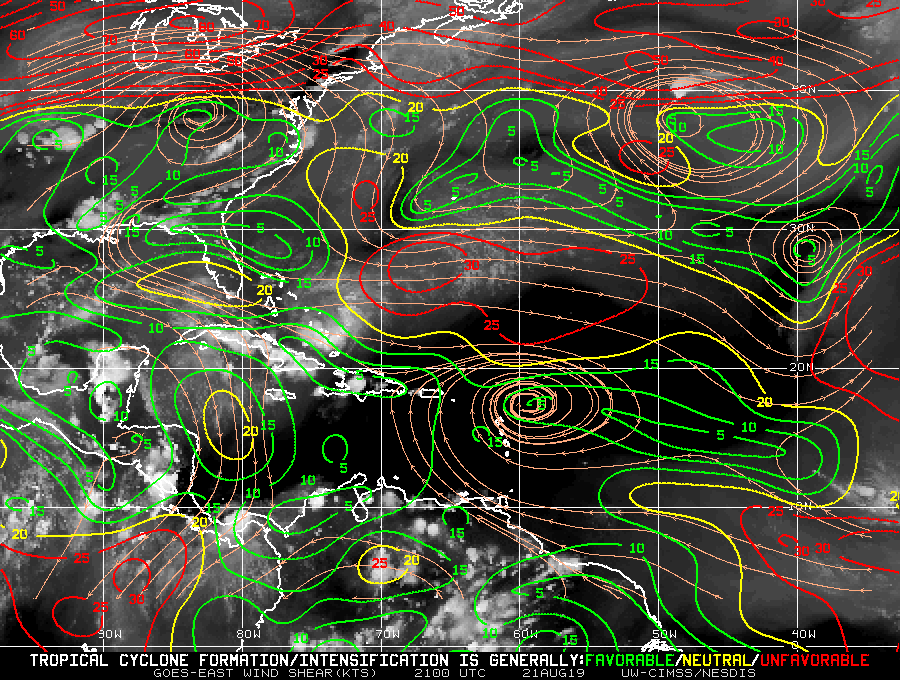
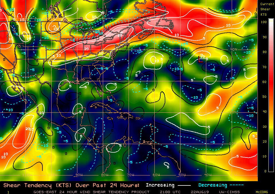
The timing is a little concerning but the -VP200 over Africa/IO is actually the best for the Atlantic.

Image

Yes, this is the best look for long-track Cape Verde hurricanes at least. Caribbean systems would be over the NAtl proper, but the upwards motion is most important in the genesis region of disturbances, which for Cape Verde hurricanes is Africa. Background vertical motion from things such as Madden-Julian or ENSO state is different than say TUTT subsidence and actually doesn't have much impact on a developed system, but it can absolutely eliminate a disturbance before it can get going.

This holds true for the WPac, which is especially notable in El Nino years. If the best upwards motion is over the CPac, coherent disturbances cross the IDL and become powerful and long lived typhoons. Below is a few images from the 1997 JTWC report. Remind you of anything?

Image

Image

Image
8 likes   
Contract Meteorologist. TAMU & MSST. Fiercely authentic, one of a kind. We are all given free will, so choose a life meant to be lived. We are the Masters of our own Stories.
Opinions expressed are mine alone.

Follow me on Twitter at @1900hurricane : Read blogs at https://1900hurricane.wordpress.com/

User avatar
CyclonicFury
Category 5
Category 5
Posts: 1975
Age: 25
Joined: Sun Jul 02, 2017 12:32 pm
Location: NC
Contact:

Re: 2019 Indicators: SST'S / Sal / MSLP / Steering / Shear / Instability (See updated graphics at first post)

#1042 Postby CyclonicFury » Tue Aug 20, 2019 9:09 pm

2019 will NOT be joining the elusive club of years without an Atlantic TC in August.
9 likes   
NCSU B.S. in Meteorology Class of 2021. Tropical weather blogger at http://www.cyclonicfury.com. My forecasts and thoughts are NOT official, for official forecasts please consult the National Hurricane Center.

User avatar
DioBrando
Category 4
Category 4
Posts: 917
Age: 27
Joined: Sun Aug 12, 2018 12:45 pm

Re: 2019 Indicators: SST'S / Sal / MSLP / Steering / Shear / Instability (See updated graphics at first post)

#1043 Postby DioBrando » Tue Aug 20, 2019 9:10 pm

CyclonicFury wrote:2019 will NOT be joining the elusive club of years without an Atlantic TC in August.

Chantal just got named
Dreams have been crushed

"I walk this empty street
On the boulevard of broken dreams"
8 likes   
blonde stacey (xe/xem/xir)

User avatar
Hammy
Category 5
Category 5
Posts: 5594
Age: 40
Joined: Fri May 25, 2012 5:25 pm
Contact:

Re: 2019 Indicators: SST'S / Sal / MSLP / Steering / Shear / Instability (See updated graphics at first post)

#1044 Postby Hammy » Tue Aug 20, 2019 10:46 pm

I was looking at Papin's satellite animations for August 1999 and it actually looks pretty similar to this year, with the waves coming off well north of normal, up until the 18th or so (though any change this year will obviously be delayed) and both the East and West Pacific appeared quite a bit below normal, with the west having a lot of weaker and higher-latitude systems, and east having only 9/6/2. Does anybody know if there were any similarities to the atmosphere as this year as far as MJO/sinking motion/SSTs as I'm not sure where to look for most of the data
4 likes   
The above post is not official and should not be used as such. It is the opinion of the poster and may or may not be backed by sound meteorological data. It is not endorsed by any professional institution or storm2k.org. For official information, please refer to the NHC and NWS products.

User avatar
chaser1
S2K Supporter
S2K Supporter
Posts: 4681
Age: 63
Joined: Sat Oct 15, 2005 5:59 pm
Location: Longwood, Fl

Re: 2019 Indicators: SST'S / Sal / MSLP / Steering / Shear / Instability (See updated graphics at first post)

#1045 Postby chaser1 » Wed Aug 21, 2019 1:10 am

The magic switch has been flipped (though, Chantal will likely track closer to calving ice then it will to the MDR). This ain't your Grandfather's Hurricane Season LOL! Anyone want to bet against the likelihood that Dorian will likely form north of 25N latitude as well?
2 likes   
Personal Forecast Disclaimer:
The posts in this forum are NOT official forecast and should not be used as such. They are just the opinion of the poster and may or may not be backed by sound meteorological data. They are NOT endorsed by any professional institution or storm2k.org. For official information, please refer to the NHC and NWS products.


User avatar
Kingarabian
S2K Supporter
S2K Supporter
Posts: 15434
Joined: Sat Aug 08, 2009 3:06 am
Location: Honolulu, Hawaii

Re: 2019 Indicators: SST'S / Sal / MSLP / Steering / Shear / Instability (See updated graphics at first post)

#1046 Postby Kingarabian » Wed Aug 21, 2019 2:46 am

CyclonicFury wrote:2019 will NOT be joining the elusive club of years without an Atlantic TC in August.

Would've been a cool sight to see though. Oh well.
2 likes   
RIP Kobe Bryant

User avatar
chaser1
S2K Supporter
S2K Supporter
Posts: 4681
Age: 63
Joined: Sat Oct 15, 2005 5:59 pm
Location: Longwood, Fl

Re: 2019 Indicators: SST'S / Sal / MSLP / Steering / Shear / Instability (See updated graphics at first post)

#1047 Postby chaser1 » Wed Aug 21, 2019 7:22 am

I'm not suggesting that a good deal of quality tropical systems are about to take the stage but I'm seeing an increased moisture envelope pushing off Africa and a bit less latitude suppressed tropical waves reaching the W. Carib. I think we'll begin seeing a marked increase of model "pings" for tropical development beginning today/new couple days. That doesn't suggest a marked increase in development is about to occur but it might suggest that a "relative" increase may begin during the next week or two. That's certainly no shocker given the time of year and still only indicative of an up-tick to still somewhat anemic season
6 likes   
Personal Forecast Disclaimer:
The posts in this forum are NOT official forecast and should not be used as such. They are just the opinion of the poster and may or may not be backed by sound meteorological data. They are NOT endorsed by any professional institution or storm2k.org. For official information, please refer to the NHC and NWS products.


storminabox
Category 1
Category 1
Posts: 260
Joined: Sun Jul 09, 2017 10:50 pm

Re: 2019 Indicators: SST'S / Sal / MSLP / Steering / Shear / Instability (See updated graphics at first post)

#1048 Postby storminabox » Wed Aug 21, 2019 7:52 am

chaser1 wrote:I'm not suggesting that a good deal of quality tropical systems are about to take the stage but I'm seeing an increased moisture envelope pushing off Africa and a bit less latitude suppressed tropical waves reaching the W. Carib. I think we'll begin seeing a marked increase of model "pings" for tropical development beginning today/new couple days. That doesn't suggest a marked increase in development is about to occur but it might suggest that a "relative" increase may begin during the next week or two. That's certainly no shocker given the time of year and still only indicative of an up-tick to still somewhat anemic season


Atleast it’s something
0 likes   

User avatar
NotSparta
Professional-Met
Professional-Met
Posts: 1648
Age: 22
Joined: Fri Aug 18, 2017 8:24 am
Location: Naples, FL
Contact:

Re: 2019 Indicators: SST'S / Sal / MSLP / Steering / Shear / Instability (See updated graphics at first post)

#1049 Postby NotSparta » Wed Aug 21, 2019 8:49 pm

Shear has really come down:

Image
4 likes   
This post was probably an opinion of mine, and in no way is official. Please refer to http://www.hurricanes.gov for official tropical analysis and advisories.

My website, with lots of tropical wx graphics, including satellite and recon: http://cyclonicwx.com

User avatar
Hurricaneman
Category 5
Category 5
Posts: 7281
Age: 43
Joined: Tue Aug 31, 2004 3:24 pm
Location: central florida

Re: 2019 Indicators: SST'S / Sal / MSLP / Steering / Shear / Instability (See updated graphics at first post)

#1050 Postby Hurricaneman » Wed Aug 21, 2019 11:25 pm

It seems now we have waves that are maintaining convection which indicates the sinking motion is leaving and by early next week into October it’s full steam ahead as it looks to me
6 likes   

User avatar
NDG
S2K Supporter
S2K Supporter
Posts: 14933
Joined: Sun Jul 09, 2006 10:14 pm
Location: Orlando, FL

Re: 2019 Indicators: SST'S / Sal / MSLP / Steering / Shear / Instability (See updated graphics at first post)

#1051 Postby NDG » Thu Aug 22, 2019 6:20 am


Yep, it can't get any lower than this across the western MDR and most of the Caribbean. Is a bone dry very low windshear environment :double:

Image
Image
2 likes   

User avatar
SFLcane
S2K Supporter
S2K Supporter
Posts: 9606
Age: 46
Joined: Sat Jun 05, 2010 1:44 pm
Location: Lake Worth Florida

Re: 2019 Indicators: SST'S / Sal / MSLP / Steering / Shear / Instability (See updated graphics at first post)

#1052 Postby SFLcane » Thu Aug 22, 2019 7:56 am

Nothing is going on I guess when we are taking about rainbows at the nhc . :lol:

 https://twitter.com/NWSNHC/status/1164515344234377216


3 likes   

User avatar
SoupBone
Category 5
Category 5
Posts: 3073
Joined: Tue Sep 20, 2005 5:24 pm

Re: 2019 Indicators: SST'S / Sal / MSLP / Steering / Shear / Instability (See updated graphics at first post)

#1053 Postby SoupBone » Thu Aug 22, 2019 8:40 am

NDG wrote:


Yep, it can't get any lower than this across the western MDR and most of the Caribbean. Is a bone dry very low windshear environment :double:

https://i.imgur.com/9uRGhJC.gif
https://i.imgur.com/KcsvaH8.png


Yep, right now SAL is still potent and has made a huge push south again in the last few days. Just when it looks like he's done for the season he roars right back. I'm curious what's the longest that SAL has been a big factor in seasons. This season seems like he's not going away, when he typically peaks in late July. Yet, here we are. :lol:
1 likes   
Personal Forecast Disclaimer:
The posts in this forum are NOT official forecast and should not be used as such. They are just the opinion of the poster and may or may not be backed by sound meteorological data. They are NOT endorsed by any professional institution or storm2k.org. For official information, please refer to the NHC and NWS products.

User avatar
SoupBone
Category 5
Category 5
Posts: 3073
Joined: Tue Sep 20, 2005 5:24 pm

Re: 2019 Indicators: SST'S / Sal / MSLP / Steering / Shear / Instability (See updated graphics at first post)

#1054 Postby SoupBone » Thu Aug 22, 2019 9:22 am

This to me is amazing for late August. Anyone else remember SAL hanging around this long, and still this potent?

Image
2 likes   
Personal Forecast Disclaimer:
The posts in this forum are NOT official forecast and should not be used as such. They are just the opinion of the poster and may or may not be backed by sound meteorological data. They are NOT endorsed by any professional institution or storm2k.org. For official information, please refer to the NHC and NWS products.

User avatar
Hammy
Category 5
Category 5
Posts: 5594
Age: 40
Joined: Fri May 25, 2012 5:25 pm
Contact:

Re: 2019 Indicators: SST'S / Sal / MSLP / Steering / Shear / Instability (See updated graphics at first post)

#1055 Postby Hammy » Thu Aug 22, 2019 9:24 am

CFS showing relatively little activity overall for the season now for the last three runs and no longer trending in any direction, seems like the updated climate forecast is now showing up in the model runs. Modest activity during September, nothing to speak of before September 10 or so, and really nothing after the first week of October.
1 likes   
The above post is not official and should not be used as such. It is the opinion of the poster and may or may not be backed by sound meteorological data. It is not endorsed by any professional institution or storm2k.org. For official information, please refer to the NHC and NWS products.

User avatar
NotSparta
Professional-Met
Professional-Met
Posts: 1648
Age: 22
Joined: Fri Aug 18, 2017 8:24 am
Location: Naples, FL
Contact:

Re: 2019 Indicators: SST'S / Sal / MSLP / Steering / Shear / Instability (See updated graphics at first post)

#1056 Postby NotSparta » Thu Aug 22, 2019 10:21 am

SoupBone wrote:This to me is amazing for late August. Anyone else remember SAL hanging around this long, and still this potent?

https://i.imgur.com/1Hm6nkq.jpg


Might be the new product that makes it look more intense

Older one, better for comparisons to previous seasons

Image
4 likes   
This post was probably an opinion of mine, and in no way is official. Please refer to http://www.hurricanes.gov for official tropical analysis and advisories.

My website, with lots of tropical wx graphics, including satellite and recon: http://cyclonicwx.com

User avatar
SoupBone
Category 5
Category 5
Posts: 3073
Joined: Tue Sep 20, 2005 5:24 pm

Re: 2019 Indicators: SST'S / Sal / MSLP / Steering / Shear / Instability (See updated graphics at first post)

#1057 Postby SoupBone » Thu Aug 22, 2019 10:51 am

NotSparta wrote:
SoupBone wrote:This to me is amazing for late August. Anyone else remember SAL hanging around this long, and still this potent?

https://i.imgur.com/1Hm6nkq.jpg


Might be the new product that makes it look more intense

Older one, better for comparisons to previous seasons

https://i.imgur.com/qlPu47R.jpg


That's strange because the current legend shows those really light areas as pretty potent dust. Pretty stark differences.
1 likes   
Personal Forecast Disclaimer:
The posts in this forum are NOT official forecast and should not be used as such. They are just the opinion of the poster and may or may not be backed by sound meteorological data. They are NOT endorsed by any professional institution or storm2k.org. For official information, please refer to the NHC and NWS products.

User avatar
cycloneye
Admin
Admin
Posts: 139077
Age: 67
Joined: Thu Oct 10, 2002 10:54 am
Location: San Juan, Puerto Rico

Re: 2019 Indicators: SST'S / Sal / MSLP / Steering / Shear / Instability (See updated graphics at first post)

#1058 Postby cycloneye » Thu Aug 22, 2019 11:54 am

5 likes   
Visit the Caribbean-Central America Weather Thread where you can find at first post web cams,radars
and observations from Caribbean basin members Click Here

psyclone
S2K Supporter
S2K Supporter
Posts: 4487
Joined: Wed Aug 24, 2005 9:04 pm
Location: palm harbor fl

Re: 2019 Indicators: SST'S / Sal / MSLP / Steering / Shear / Instability (See updated graphics at first post)

#1059 Postby psyclone » Thu Aug 22, 2019 12:34 pm

Interesting to note that a couple of those quiet starts referenced by Dr Phil ended generating plenty of activity...1988's Gilbert and 2002 with Isidore among others. This season could end up a snooze fest...or not. The coin is still in the air even though the slow season crowd is decisively ahead at this point..
8 likes   

User avatar
gatorcane
S2K Supporter
S2K Supporter
Posts: 23499
Age: 46
Joined: Sun Mar 13, 2005 3:54 pm
Location: Boca Raton, FL

Re: 2019 Indicators: SST'S / Sal / MSLP / Steering / Shear / Instability (See updated graphics at first post)

#1060 Postby gatorcane » Thu Aug 22, 2019 8:32 pm

Surprised nobody has mentioned how there is now little shear over the entire Caribbean. Should just be a matter of time before things really get going. That area of the SW Atlantic is another area where we could see some activity.

Got to think we will see some significant Caribbean system(s) this year with no El Niño. My eyes are looking to the south here in Florida this year and not so much to the east especially with the troughiness pattern:

Image
5 likes   


Return to “Talkin' Tropics”

Who is online

Users browsing this forum: Google Adsense [Bot], TheAustinMan and 186 guests