2019 Indicators: SST'S / Sal / MSLP / Steering / Shear / Instability (See updated graphics at first post)
Moderator: S2k Moderators
Forum rules

The posts in this forum are NOT official forecasts and should not be used as such. They are just the opinion of the poster and may or may not be backed by sound meteorological data. They are NOT endorsed by any professional institution or STORM2K. For official information, please refer to products from the National Hurricane Center and National Weather Service.
-
Emmett_Brown

- Category 5

- Posts: 1343
- Joined: Wed Aug 24, 2005 9:10 pm
- Location: Sarasota FL
Re: 2019 Indicators: SST'S / Sal / MSLP / Steering / Shear / Instability (See updated graphics at first post)
As much as I like to track storms, I always admire a good anomaly! I am definitely rooting for no storms in August to complete our perfect score. If you're going to have a drought, you might as well do it right!
Last edited by Emmett_Brown on Mon Aug 19, 2019 5:38 pm, edited 2 times in total.
5 likes
-
toad strangler

- S2K Supporter

- Posts: 4165
- Joined: Sun Jul 28, 2013 3:09 pm
- Location: Earth
- Contact:
Re: 2019 Indicators: SST'S / Sal / MSLP / Steering / Shear / Instability (See updated graphics at first post)
SoupBone wrote:NDG wrote::uarrow: Look at all of the sinking motion it also forecasts for the central & EPAC, I don't know about that.
SAL says, "I'm supposed to peak in late July? Not this year!"
Oy vey that is gangster. You can bet on AT LEAST another two weeks of zippo.
1 likes

Re: 2019 Indicators: SST'S / Sal / MSLP / Steering / Shear / Instability (See updated graphics at first post)
NDG wrote::uarrow: Look at all of the sinking motion it also forecasts for the central & EPAC, I don't know about that.
I think the sinking motion it shows in CPAC/EPAC is south of the equator where cold water anomalies have been increasing.
2 likes
The above post and any post by Ntxw is NOT an official forecast and should not be used as such. It is just the opinion of the poster and may or may not be backed by sound meteorological data. It is NOT endorsed by any professional institution including Storm2k. For official information, please refer to NWS products.
Help support Storm2K!
-
StruThiO

- Category 3

- Posts: 821
- Age: 24
- Joined: Fri Sep 15, 2017 5:51 am
- Location: Currently Portland, OR. Raised in Jax, FL.
Re: 2019 Indicators: SST'S / Sal / MSLP / Steering / Shear / Instability (See updated graphics at first post)
Yeah, the 15s-15n bounds is pretty large. Is there say a 10n-20n product?
0 likes


Re: 2019 Indicators: SST'S / Sal / MSLP / Steering / Shear / Instability (See updated graphics at first post)
Tell me tell me tell me, what is up with the atmosphere making it so hostile?
Even the most optimistic of posters have turned bearish.
I'm highly skeptical of the CCKW.
Even the most optimistic of posters have turned bearish.
I'm highly skeptical of the CCKW.
0 likes
blonde stacey (xe/xem/xir)
-
AutoPenalti
- Category 5
- Posts: 3949
- Age: 27
- Joined: Mon Aug 17, 2015 4:16 pm
- Location: Ft. Lauderdale, Florida
Re: 2019 Indicators: SST'S / Sal / MSLP / Steering / Shear / Instability (See updated graphics at first post)
DioBrando wrote:Tell me tell me tell me, what is up with the atmosphere making it so hostile?
Even the most optimistic of posters have turned bearish.
I'm highly skeptical of the CCKW.
Again, nothing is wrong with the atmosphere. We are still in a phase where large scale conditions aren’t favorable. They won’t be favorable for a while.
Patience, we will have our fishes soon.
3 likes
The posts in this forum are NOT official forecasts and should not be used as such. They are just the opinion of the poster and may or may not be backed by sound meteorological data. They are NOT endorsed by any professional institution or STORM2K. For official information, please refer to products from the NHC and NWS.
Model Runs Cheat Sheet:
GFS (5:30 AM/PM, 11:30 AM/PM)
HWRF, GFDL, UKMET, NAVGEM (6:30-8:00 AM/PM, 12:30-2:00 AM/PM)
ECMWF (1:45 AM/PM)
TCVN is a weighted averaged
Re: 2019 Indicators: SST'S / Sal / MSLP / Steering / Shear / Instability (See updated graphics at first post)
AutoPenalti wrote:DioBrando wrote:Tell me tell me tell me, what is up with the atmosphere making it so hostile?
Even the most optimistic of posters have turned bearish.
I'm highly skeptical of the CCKW.
Again, nothing is wrong with the atmosphere. We are still in a phase where large scale conditions aren’t favorable. They won’t be favorable for a while.
Patience, we will have our fishes soon.
do you have any examples?
0 likes
blonde stacey (xe/xem/xir)
Re: 2019 Indicators: SST'S / Sal / MSLP / Steering / Shear / Instability (See updated graphics at first post)
This basin is lazin'
on the night before the 8-20 bell ding
all we hear is crickets sing
While it's torture for most
wxman can boast
bearish from go, it's nearly heaven
more slow season bike rides, for wxman 57!
Happy season cancel awareness day everyone!
on the night before the 8-20 bell ding
all we hear is crickets sing
While it's torture for most
wxman can boast
bearish from go, it's nearly heaven
more slow season bike rides, for wxman 57!
Happy season cancel awareness day everyone!
14 likes
-
AutoPenalti
- Category 5
- Posts: 3949
- Age: 27
- Joined: Mon Aug 17, 2015 4:16 pm
- Location: Ft. Lauderdale, Florida
Re: 2019 Indicators: SST'S / Sal / MSLP / Steering / Shear / Instability (See updated graphics at first post)
DioBrando wrote:AutoPenalti wrote:DioBrando wrote:Tell me tell me tell me, what is up with the atmosphere making it so hostile?
Even the most optimistic of posters have turned bearish.
I'm highly skeptical of the CCKW.
Again, nothing is wrong with the atmosphere. We are still in a phase where large scale conditions aren’t favorable. They won’t be favorable for a while.
Patience, we will have our fishes soon.
do you have any examples?
Sure, look at the TPW and how retrograded it is. The WAM is further north which means any wave that tries to develop will be filtered out by the SAL, furthermore, we are not in a favorable MJO phase for rising air, any thunderstorm activity will most likely be scattered and sheared, lastly, I believe there is some mid-level dry air surrounding much of the MDR and eastern Caribbean. All this will last for quite a while, but it will only be a matter of time when we get our third storm of the season.
1 likes
The posts in this forum are NOT official forecasts and should not be used as such. They are just the opinion of the poster and may or may not be backed by sound meteorological data. They are NOT endorsed by any professional institution or STORM2K. For official information, please refer to products from the NHC and NWS.
Model Runs Cheat Sheet:
GFS (5:30 AM/PM, 11:30 AM/PM)
HWRF, GFDL, UKMET, NAVGEM (6:30-8:00 AM/PM, 12:30-2:00 AM/PM)
ECMWF (1:45 AM/PM)
TCVN is a weighted averaged
-
CyclonicFury

- Category 5
- Posts: 1975
- Age: 25
- Joined: Sun Jul 02, 2017 12:32 pm
- Location: NC
- Contact:
Re: 2019 Indicators: SST'S / Sal / MSLP / Steering / Shear / Instability (See updated graphics at first post)
This is the second year in a row August has been very quiet, though last year we did have Debby and Ernesto form in the subtropics. The ECMWF is showing a strong wave with a closed circulation at the end of the run exiting Africa, which is how it usually depicts the start of a more active period.
8 likes
NCSU B.S. in Meteorology Class of 2021. Tropical weather blogger at http://www.cyclonicfury.com. My forecasts and thoughts are NOT official, for official forecasts please consult the National Hurricane Center.
-
gatorcane

- S2K Supporter
- Posts: 23499
- Age: 46
- Joined: Sun Mar 13, 2005 3:54 pm
- Location: Boca Raton, FL
Re: 2019 Indicators: SST'S / Sal / MSLP / Steering / Shear / Instability (See updated graphics at first post)
That is some wave over Africa tonight, perhaps the wave train is finally going to get going in the near future?
5 likes
-
dexterlabio
- Category 5
- Posts: 3407
- Joined: Sat Oct 24, 2009 11:50 pm
Re: 2019 Indicators: SST'S / Sal / MSLP / Steering / Shear / Instability (See updated graphics at first post)
I thought the enhanced phase of the MJO/CCKW already reached the Atlantic? It seems pretty dry in the Pacific right now with the suppressed phase and if it's also the same case in the Western Hemisphere then where on Earth is the MJO? 
0 likes
Personal Forecast Disclaimer:
The posts in this forum are NOT official forecast and should not be used as such. They are just the opinion of the poster and may or may not be backed by sound meteorological data. They are NOT endorsed by any professional institution or storm2k.org. For official information, please refer to the NHC and NWS products.
The posts in this forum are NOT official forecast and should not be used as such. They are just the opinion of the poster and may or may not be backed by sound meteorological data. They are NOT endorsed by any professional institution or storm2k.org. For official information, please refer to the NHC and NWS products.
-
wxman57

- Moderator-Pro Met

- Posts: 22482
- Age: 66
- Joined: Sat Jun 21, 2003 8:06 pm
- Location: Houston, TX (southwest)
Re: 2019 Indicators: SST'S / Sal / MSLP / Steering / Shear / Instability (See updated graphics at first post)
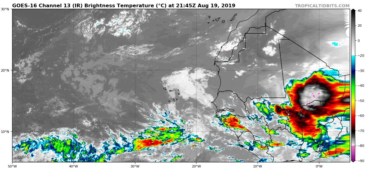
SoupBone wrote:That is some wave over Africa tonight, perhaps the wave train is finally going to get going in the near future?
https://i.postimg.cc/mZdgjCVW/goes16-ir-eatl-201908192145.jpg
The 18Z GFS and 12Z Euro both have it dissipating as it reaches the Atlantic. Euro sees something strong moving offshore in 10 days, though. The air in the deep tropics remains quite stable. Plenty of dry, sinking air.
5 likes
-
cycloneye

- Admin

- Posts: 139178
- Age: 67
- Joined: Thu Oct 10, 2002 10:54 am
- Location: San Juan, Puerto Rico
Re: 2019 Indicators: SST'S / Sal / MSLP / Steering / Shear / Instability (See updated graphics at first post)
3 likes
Visit the Caribbean-Central America Weather Thread where you can find at first post web cams,radars
and observations from Caribbean basin members Click Here
and observations from Caribbean basin members Click Here
-
Hurricaneman

- Category 5
- Posts: 7282
- Age: 43
- Joined: Tue Aug 31, 2004 3:24 pm
- Location: central florida
Re: 2019 Indicators: SST'S / Sal / MSLP / Steering / Shear / Instability (See updated graphics at first post)
That wave coming off of Africa in the Euro 10 day may be one or even the one ahead of it to watch as the sinking air dissipates
0 likes

Re: 2019 Indicators: SST'S / Sal / MSLP / Steering / Shear / Instability (See updated graphics at first post)
dexterlabio wrote:I thought the enhanced phase of the MJO/CCKW already reached the Atlantic? It seems pretty dry in the Pacific right now with the suppressed phase and if it's also the same case in the Western Hemisphere then where on Earth is the MJO?
Thank you, LOL !
0 likes
Personal Forecast Disclaimer:
The posts in this forum are NOT official forecast and should not be used as such. They are just the opinion of the poster and may or may not be backed by sound meteorological data. They are NOT endorsed by any professional institution or storm2k.org. For official information, please refer to the NHC and NWS products.
The posts in this forum are NOT official forecast and should not be used as such. They are just the opinion of the poster and may or may not be backed by sound meteorological data. They are NOT endorsed by any professional institution or storm2k.org. For official information, please refer to the NHC and NWS products.
-
Stormi

- Tropical Depression

- Posts: 84
- Age: 36
- Joined: Sun Aug 18, 2019 10:04 pm
- Location: Northeast FL
Re: 2019 Indicators: SST'S / Sal / MSLP / Steering / Shear / Instability (See updated graphics at first post)
Hammy - you've suggested that most models show at least one long-tracking system. May I ask where they place it? Just curious  I'm still a bit new to this & am trying to get a handle on utilizing all of these models
0 likes

Re: 2019 Indicators: SST'S / Sal / MSLP / Steering / Shear / Instability (See updated graphics at first post)
Stormi wrote:Hammy - you've suggested that most models show at least one long-tracking system. May I ask where they place it? Just curious
The most frequent track over the last several days worth of runs has been turning north between 40 and 55 longitude and staying largely out to sea, though some runs (and we're talking 3+ weeks out here) bringing it close to New England or maritime Canada. New run should be coming out in a few hours.
Any word on how many storms the Euro is forecasting during that time?
1 likes
The above post is not official and should not be used as such. It is the opinion of the poster and may or may not be backed by sound meteorological data. It is not endorsed by any professional institution or storm2k.org. For official information, please refer to the NHC and NWS products.
-
Stormi
- Tropical Depression
- Posts: 84
- Age: 36
- Joined: Sun Aug 18, 2019 10:04 pm
- Location: Northeast FL
Re: 2019 Indicators: SST'S / Sal / MSLP / Steering / Shear / Instability (See updated graphics at first post)
My best guess will for now will be between 4-6. I'm still very new to this, but doing lots of research as I just switched coastlines 
0 likes
Who is online
Users browsing this forum: AnnularCane, pepeavilenho, SFLcane, SteveM, TheAustinMan, TheWisestofAll and 238 guests