2019 Tropics: Global Model Runs Discussion (Out to day 16)

This is the general tropical discussion area. Anyone can take their shot at predicting a storms path.

Moderator: S2k Moderators

Forum rules

The posts in this forum are NOT official forecasts and should not be used as such. They are just the opinion of the poster and may or may not be backed by sound meteorological data. They are NOT endorsed by any professional institution or STORM2K. For official information, please refer to products from the National Hurricane Center and National Weather Service.

Help Support Storm2K
Message
Author
User avatar
CyclonicFury
Category 5
Category 5
Posts: 1975
Age: 25
Joined: Sun Jul 02, 2017 12:32 pm
Location: NC
Contact:

Re: 2019 Tropics: Global Model Runs Discussion (Out to day 16)

#241 Postby CyclonicFury » Tue Jul 16, 2019 10:56 pm

floridasun78 wrote:i don't any thing until after aug 15 the Atlantic and Caribbean are dead zone for tropical weather their alot sal moving cross the tropical and shear not good system and dry air too killing storms try form only area watch home grown system like barry none big models show any thing

It's possible that we don't see any development until then, but it's very normal to have lulls of activity in the Atlantic this time of year due to SAL and strong trade winds over the deep tropics. It's not surprising the models don't show anything. I'm not so sure the first half of August will be dead, though. Shear in the MDR and Caribbean has recently dropped below normal.
6 likes   
NCSU B.S. in Meteorology Class of 2021. Tropical weather blogger at http://www.cyclonicfury.com. My forecasts and thoughts are NOT official, for official forecasts please consult the National Hurricane Center.

User avatar
GCANE
S2K Supporter
S2K Supporter
Posts: 10787
Joined: Mon Oct 22, 2007 8:03 am

Re: 2019 Tropics: Global Model Runs Discussion (Out to day 16)

#242 Postby GCANE » Wed Jul 17, 2019 3:40 am

Wave coming off Africa looks somewhat interesting. High and good LL Vort.
Latest GFS has it crossing the Atlantic with convection into the east Carib.
Robost circulation seems to be sweeping out SAL in front of it, albeit SAL is very dense. Need to see if this gets entrained or not.
Could be the first protected pouch of the season which models are never good at forecasting.
Maybe something to talk about when it hits 50W.
5 likes   

User avatar
CFLHurricane
Category 1
Category 1
Posts: 312
Joined: Thu Mar 27, 2014 5:56 pm
Location: Floriduh

Re: 2019 Tropics: Global Model Runs Discussion (Out to day 16)

#243 Postby CFLHurricane » Wed Jul 17, 2019 7:34 am

GCANE wrote:Wave coming off Africa looks somewhat interesting. High and good LL Vort.


Absolutely! It’s stunning to see how easily it’s forcing the ITCZ to bend to its will. No doubt it will make it across if it can drag its umbilical cord with it.
2 likes   
I'm not a meteorologist, but I did stay at a motel 8.

User avatar
SEASON_CANCELED
Category 3
Category 3
Posts: 887
Joined: Mon Jul 06, 2009 5:17 am
Location: 8 Bit Charlie Sheen

Re: 2019 Tropics: Global Model Runs Discussion (Out to day 16)

#244 Postby SEASON_CANCELED » Wed Jul 17, 2019 8:08 am

CFLHurricane wrote:
GCANE wrote:Wave coming off Africa looks somewhat interesting. High and good LL Vort.


Absolutely! It’s stunning to see how easily it’s forcing the ITCZ to bend to its will. No doubt it will make it across if it can drag its umbilical cord with it.


It may make it. By the time it gets over that way it will be the 24thish...I would say thats close enough to peak season in climate terms
1 likes   
i am a big stupid ugly moron with an ugly face and a big butt and my butt stinks and i like to kiss my own butt

User avatar
SoupBone
Category 5
Category 5
Posts: 3073
Joined: Tue Sep 20, 2005 5:24 pm

Re: 2019 Tropics: Global Model Runs Discussion (Out to day 16)

#245 Postby SoupBone » Wed Jul 17, 2019 9:35 am

SEASON_CANCELED wrote:
CFLHurricane wrote:
GCANE wrote:Wave coming off Africa looks somewhat interesting. High and good LL Vort.


Absolutely! It’s stunning to see how easily it’s forcing the ITCZ to bend to its will. No doubt it will make it across if it can drag its umbilical cord with it.


It may make it. By the time it gets over that way it will be the 24thish...I would say thats close enough to peak season in climate terms


Doesn't SAL start peaking toward the end of July? I remember usually seeing a huge push of dust around the end of July.
0 likes   
Personal Forecast Disclaimer:
The posts in this forum are NOT official forecast and should not be used as such. They are just the opinion of the poster and may or may not be backed by sound meteorological data. They are NOT endorsed by any professional institution or storm2k.org. For official information, please refer to the NHC and NWS products.

User avatar
artist
Category 5
Category 5
Posts: 9793
Joined: Mon Jun 06, 2005 3:26 pm
Location: West Palm

Re: 2019 Tropics: Global Model Runs Discussion (Out to day 16)

#246 Postby artist » Wed Jul 17, 2019 10:24 am

SoupBone wrote:
SEASON_CANCELED wrote:
CFLHurricane wrote:
Absolutely! It’s stunning to see how easily it’s forcing the ITCZ to bend to its will. No doubt it will make it across if it can drag its umbilical cord with it.


It may make it. By the time it gets over that way it will be the 24thish...I would say thats close enough to peak season in climate terms


Doesn't SAL start peaking toward the end of July? I remember usually seeing a huge push of dust around the end of July.


http://tropic.ssec.wisc.edu/misc/sal/info.html
SAL activity (described by the size and westward reach of the outbreaks) begins to rapidly increase in early June, peaks from mid-June through late July, and begins to subside in early August.
0 likes   

User avatar
GCANE
S2K Supporter
S2K Supporter
Posts: 10787
Joined: Mon Oct 22, 2007 8:03 am

Re: 2019 Tropics: Global Model Runs Discussion (Out to day 16)

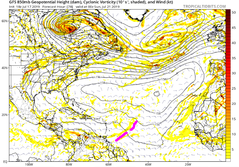
#247 Postby GCANE » Wed Jul 17, 2019 11:32 am

GFS has it as a sharp axis at 850mb as it approaches the islands Saturday.
It then amplifies it to a broader axis at 700mb.
355K PV loks conducive then and will move into much more unstable air and warmer SSTs.
0 likes   

floridasun78
Category 5
Category 5
Posts: 3755
Joined: Sun May 17, 2009 10:16 pm
Location: miami fl

Re: 2019 Tropics: Global Model Runs Discussion (Out to day 16)

#248 Postby floridasun78 » Wed Jul 17, 2019 3:03 pm

GCANE wrote:GFS has it as a sharp axis at 850mb as it approaches the islands Saturday.
It then amplifies it to a broader axis at 700mb.
355K PV loks conducive then and will move into much more unstable air and warmer SSTs.

i dont see any thing with gfs by saturday
0 likes   

User avatar
GCANE
S2K Supporter
S2K Supporter
Posts: 10787
Joined: Mon Oct 22, 2007 8:03 am

Re: 2019 Tropics: Global Model Runs Discussion (Out to day 16)

#249 Postby GCANE » Wed Jul 17, 2019 7:56 pm

Latest runs are slowing it down

Image
0 likes   

AutoPenalti
Category 5
Category 5
Posts: 3949
Age: 27
Joined: Mon Aug 17, 2015 4:16 pm
Location: Ft. Lauderdale, Florida

Re: 2019 Tropics: Global Model Runs Discussion (Out to day 16)

#250 Postby AutoPenalti » Wed Jul 17, 2019 8:21 pm

GCANE wrote:Latest runs are slowing it down

https://imagizer.imageshack.com/img923/4584/PFnLkX.png

GCANE, can you explain a bit what a sharp wave axis is? Or how it develops into something tropical?
1 likes   
The posts in this forum are NOT official forecasts and should not be used as such. They are just the opinion of the poster and may or may not be backed by sound meteorological data. They are NOT endorsed by any professional institution or STORM2K. For official information, please refer to products from the NHC and NWS.


Model Runs Cheat Sheet:
GFS (5:30 AM/PM, 11:30 AM/PM)
HWRF, GFDL, UKMET, NAVGEM (6:30-8:00 AM/PM, 12:30-2:00 AM/PM)
ECMWF (1:45 AM/PM)

TCVN
is a weighted averaged

User avatar
GCANE
S2K Supporter
S2K Supporter
Posts: 10787
Joined: Mon Oct 22, 2007 8:03 am

Re: 2019 Tropics: Global Model Runs Discussion (Out to day 16)

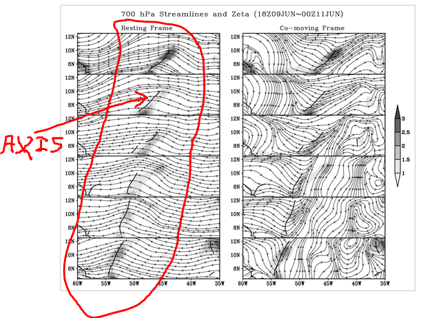
#251 Postby GCANE » Thu Jul 18, 2019 3:15 am

East to west surface winds prevail in the tropics.
A wave is defined where there is a "kink" in the winds.
In a wave, there is a distribution of winds that are SE to NW on the east of the axis and NE to SW on the west of the axis.
The axis is typically elongated and pointed SW to NE.
The more the winds deviate from E to W, the sharper the axis.

Image
6 likes   

User avatar
GCANE
S2K Supporter
S2K Supporter
Posts: 10787
Joined: Mon Oct 22, 2007 8:03 am

Re: 2019 Tropics: Global Model Runs Discussion (Out to day 16)

#252 Postby GCANE » Thu Jul 18, 2019 3:42 am

Convection below 10N from 30W to 40W.
GFS forecast to track this into southern end of east Carib.
Latest GFS has a closed off 700mb vort in 18 hrs.
SAL still very heavy ahead of this.
0 likes   

Stormcenter
S2K Supporter
S2K Supporter
Posts: 6617
Joined: Wed Sep 03, 2003 11:27 am
Location: Houston, TX

Re: 2019 Tropics: Global Model Runs Discussion (Out to day 16)

#253 Postby Stormcenter » Thu Jul 18, 2019 8:39 am

Front is expected to sag into Gulf next week, no model support yet but something to keep an eye open for in
the upcoming week.
1 likes   

User avatar
TheStormExpert
Category 5
Category 5
Posts: 8487
Age: 30
Joined: Wed Feb 16, 2011 5:38 pm
Location: Palm Beach Gardens, FL

Re: 2019 Tropics: Global Model Runs Discussion (Out to day 16)

#254 Postby TheStormExpert » Thu Jul 18, 2019 9:53 am

Stormcenter wrote:Front is expected to sag into Gulf next week, no model support yet but something to keep an eye open for in
the upcoming week.

Fronts reaching the Gulf in July!? You don’t see that too often.
0 likes   
The following post is NOT an official forecast and should not be used as such. It is just the opinion of the poster and may or may not be backed by sound meteorological data. It is NOT endorsed by storm2k.org.

User avatar
SoupBone
Category 5
Category 5
Posts: 3073
Joined: Tue Sep 20, 2005 5:24 pm

Re: 2019 Tropics: Global Model Runs Discussion (Out to day 16)

#255 Postby SoupBone » Thu Jul 18, 2019 11:16 am

TheStormExpert wrote:
Stormcenter wrote:Front is expected to sag into Gulf next week, no model support yet but something to keep an eye open for in
the upcoming week.

Fronts reaching the Gulf in July!? You don’t see that too often.


Yeah, I was in Chicago a few years ago when a cold front came through in July. I couldn't believe how nice it was. Low 70's during the day and 60's at night. Hopefully, we keep getting these early this year.
0 likes   
Personal Forecast Disclaimer:
The posts in this forum are NOT official forecast and should not be used as such. They are just the opinion of the poster and may or may not be backed by sound meteorological data. They are NOT endorsed by any professional institution or storm2k.org. For official information, please refer to the NHC and NWS products.

User avatar
TheStormExpert
Category 5
Category 5
Posts: 8487
Age: 30
Joined: Wed Feb 16, 2011 5:38 pm
Location: Palm Beach Gardens, FL

Re: 2019 Tropics: Global Model Runs Discussion (Out to day 16)

#256 Postby TheStormExpert » Thu Jul 18, 2019 12:30 pm

SoupBone wrote:
TheStormExpert wrote:
Stormcenter wrote:Front is expected to sag into Gulf next week, no model support yet but something to keep an eye open for in
the upcoming week.

Fronts reaching the Gulf in July!? You don’t see that too often.


Yeah, I was in Chicago a few years ago when a cold front came through in July. I couldn't believe how nice it was. Low 70's during the day and 60's at night. Hopefully, we keep getting these early this year.

You can thank the -NAO which looks to be going positive for the first time next week since late-April.
1 likes   
The following post is NOT an official forecast and should not be used as such. It is just the opinion of the poster and may or may not be backed by sound meteorological data. It is NOT endorsed by storm2k.org.

User avatar
wxman22
Category 3
Category 3
Posts: 825
Joined: Mon Jan 30, 2006 12:39 am
Location: Houston,Tx
Contact:

Re: 2019 Tropics: Global Model Runs Discussion (Out to day 16)

#257 Postby wxman22 » Fri Jul 19, 2019 12:49 pm

Stormcenter wrote:Front is expected to sag into Gulf next week, no model support yet but something to keep an eye open for in
the upcoming week.

Yes, I've been watching that also the global models show a trough of low pressure forming off the Texas coast as the cold front enters the gulf. Todays 12z Canadian is the first model run I've seen that shows development, of course it's the Canadian so take it for what it's worth...lol its something to watch at least.

Image
0 likes   

User avatar
GCANE
S2K Supporter
S2K Supporter
Posts: 10787
Joined: Mon Oct 22, 2007 8:03 am

Re: 2019 Tropics: Global Model Runs Discussion (Out to day 16)

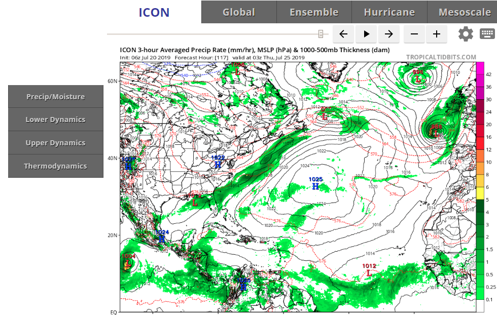
#258 Postby GCANE » Sat Jul 20, 2019 7:35 am

ICON, 117 hrs out
Surface low in the North GOM at the tail of the front.

Image
1 likes   

User avatar
GCANE
S2K Supporter
S2K Supporter
Posts: 10787
Joined: Mon Oct 22, 2007 8:03 am

Re: 2019 Tropics: Global Model Runs Discussion (Out to day 16)

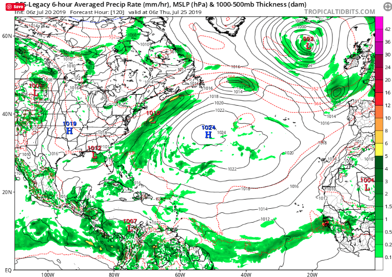
#259 Postby GCANE » Sat Jul 20, 2019 8:26 am

The old GFS, 120 hrs out.

Image
1 likes   

User avatar
SEASON_CANCELED
Category 3
Category 3
Posts: 887
Joined: Mon Jul 06, 2009 5:17 am
Location: 8 Bit Charlie Sheen

Re: 2019 Tropics: Global Model Runs Discussion (Out to day 16)

#260 Postby SEASON_CANCELED » Sat Jul 20, 2019 4:03 pm

Interesting setup
0 likes   
i am a big stupid ugly moron with an ugly face and a big butt and my butt stinks and i like to kiss my own butt


Return to “Talkin' Tropics”

Who is online

Users browsing this forum: No registered users and 192 guests