Tropical Wave in Eastern Caribbean: (Is INVEST 95L)
Moderator: S2k Moderators
Forum rules

The posts in this forum are NOT official forecasts and should not be used as such. They are just the opinion of the poster and may or may not be backed by sound meteorological data. They are NOT endorsed by any professional institution or STORM2K. For official information, please refer to products from the National Hurricane Center and National Weather Service.
-
gatorcane

- S2K Supporter

- Posts: 23499
- Age: 46
- Joined: Sun Mar 13, 2005 3:54 pm
- Location: Boca Raton, FL
Re: Tropical Wave over Lesser Antilles
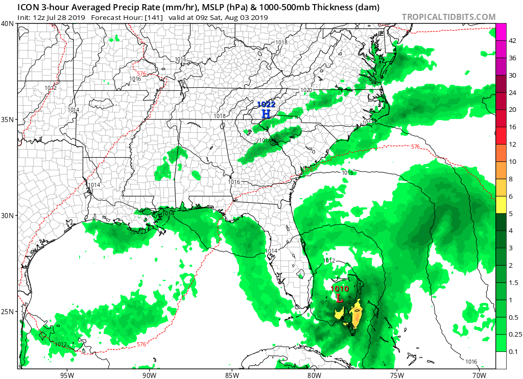
Quite a west shift by ICON which moves it very slowly north through the NW Bahamas:
2 likes

Re: Tropical Wave over Lesser Antilles
I’m hoping this shifts further west we can always use the rain.
1 likes
-
gatorcane
- S2K Supporter
- Posts: 23499
- Age: 46
- Joined: Sun Mar 13, 2005 3:54 pm
- Location: Boca Raton, FL
Re: Tropical Wave over Lesser Antilles
Notice how the GFS is already backing off on the positioning of the trough placing it further west in the latest run over Western Gulf.. See below with a comparison of 00Z and 12Z runs. Looks like a much different pattern over Canada too:
00Z last night:
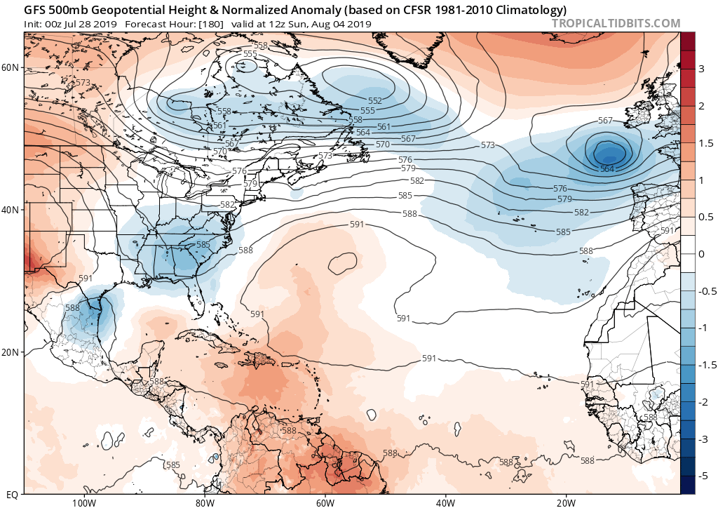
12Z today:
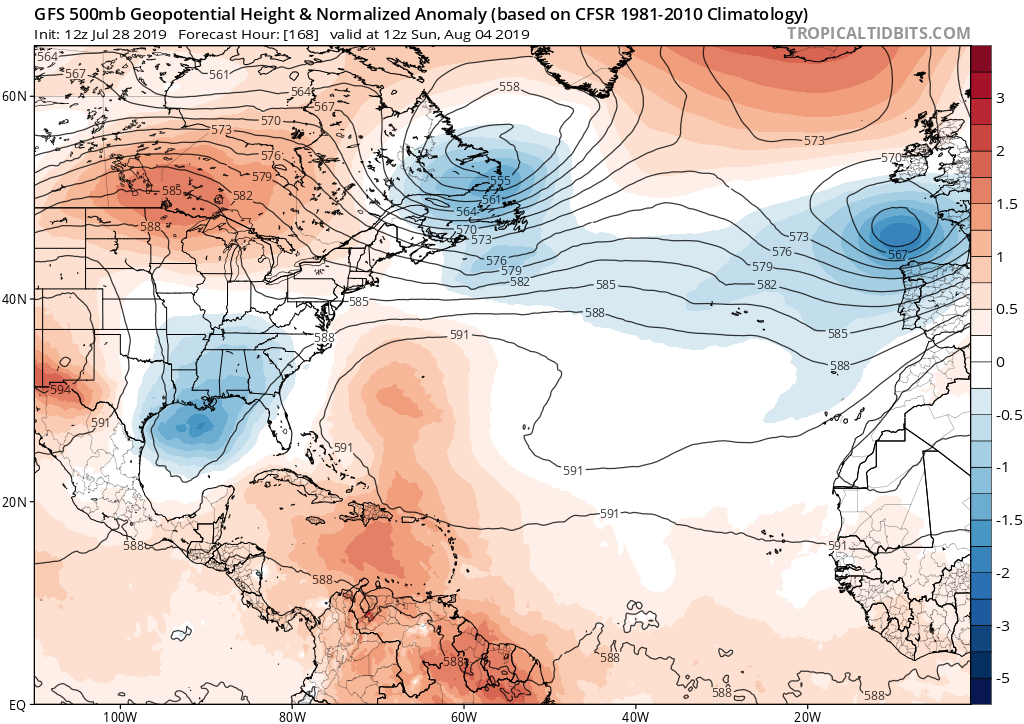
00Z last night:
12Z today:
Last edited by gatorcane on Sun Jul 28, 2019 11:39 am, edited 1 time in total.
1 likes
-
Evil Jeremy

- S2K Supporter
- Posts: 5459
- Age: 30
- Joined: Mon Apr 10, 2006 2:10 pm
- Location: Los Angeles, CA
Re: Tropical Wave over Lesser Antilles
boca wrote:I’m hoping this shifts further west we can always use the rain.
I've had enough plans cancelled in July because of rain.
Anyway, the past few years have taught me to pay attention to UKMET when it sniffs out trends early. So that's what I'm keeping an eye on next couple of days...
1 likes
Frances 04 / Jeanne 04 / Katrina 05 / Wilma 05 / Fay 08 / Debby 12 / Andrea 13 / Colin 16 / Hermine 16 / Matthew 16 / Irma 17
-
cycloneye

- Admin

- Posts: 139056
- Age: 67
- Joined: Thu Oct 10, 2002 10:54 am
- Location: San Juan, Puerto Rico
Re: Tropical Wave over Lesser Antilles
NDG wrote:One nice thing this strong tropical wave is bringing some much needed rains into the Lesser Antilles and eventual Greater Antilles.
The sure thing is beneficial rains to some of the islands including Puerto Rico that has a severe drought for the south and moderate drought for other areas.
1 likes
Visit the Caribbean-Central America Weather Thread where you can find at first post web cams,radars
and observations from Caribbean basin members Click Here
and observations from Caribbean basin members Click Here
-
gatorcane
- S2K Supporter
- Posts: 23499
- Age: 46
- Joined: Sun Mar 13, 2005 3:54 pm
- Location: Boca Raton, FL
Re: Tropical Wave over Lesser Antilles
Canadian a bit more vorticity and slightly more west. Looks closer to the UKMET:
1 likes

Re: Tropical Wave over Lesser Antilles
I'm not saying it yet but...SW winds on Grenada for a couple of hours...not an outflow boundary
https://aviationweather.gov/adds/metars ... hk_tafs=on
https://aviationweather.gov/adds/metars ... hk_tafs=on
Last edited by drezee on Sun Jul 28, 2019 11:50 am, edited 1 time in total.
0 likes

Re: Tropical Wave over Lesser Antilles
Interesting ASCAT pass, broad circulation/sharp trough.

0 likes
-
Aric Dunn
- Category 5

- Posts: 21228
- Age: 41
- Joined: Sun Sep 19, 2004 9:58 pm
- Location: Ready for the Chase.
- Contact:
Re: Tropical Wave over Lesser Antilles
drezee wrote:Im not say it yet but...SW winds on Grenada for a couple of hours...not an outflow boundary
https://www.tropicaltidbits.com/analysis/sfcplots/sfcplot_latest.png
yeah I have been watching it closely. there is a whole lot of convection.. it takes a lot of convergence to overcome the flow that is nearly always present in the eastern carrib. but there is some things to note lol..
0 likes
Note: If I make a post that is brief. Please refer back to previous posts for the analysis or reasoning. I do not re-write/qoute what my initial post said each time.
If there is nothing before... then just ask
Space & Atmospheric Physicist, Embry-Riddle Aeronautical University,
I believe the sky is falling...
If there is nothing before... then just ask
Space & Atmospheric Physicist, Embry-Riddle Aeronautical University,
I believe the sky is falling...
Re: Tropical Wave over Lesser Antilles
Ever since Hermine the eastern Gulf has had a hot hand. Here's to hoping if anything comes of this we end up on the dry side of the tracks. We do not need rain here at all...quite the opposite..
1 likes
Re: Tropical Wave over Lesser Antilles
Duplicate
Last edited by drezee on Sun Jul 28, 2019 12:21 pm, edited 1 time in total.
0 likes
Re: Tropical Wave over Lesser Antilles
Updated saved satellite loop. With it now entering the grave yard it should keep it from developing or organizing much before reaching the Greater Antilles.

0 likes
-
gatorcane
- S2K Supporter
- Posts: 23499
- Age: 46
- Joined: Sun Mar 13, 2005 3:54 pm
- Location: Boca Raton, FL
Re: Tropical Wave over Lesser Antilles
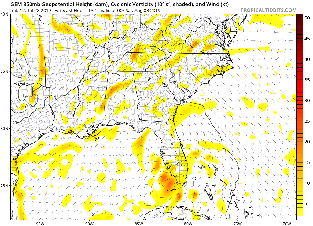
Latest 850mb vort map shows it further west than before. The models that develop near Bahamas like the northeastern part of this wave:

Anticyclone has built over top but a lot of shear ahead.

Anticyclone has built over top but a lot of shear ahead.
Last edited by gatorcane on Sun Jul 28, 2019 12:14 pm, edited 2 times in total.
0 likes
-
TheStormExpert

- Category 5
- Posts: 8487
- Age: 30
- Joined: Wed Feb 16, 2011 5:38 pm
- Location: Palm Beach Gardens, FL
Re: Tropical Wave over Lesser Antilles
If this were to end up in the Eastern Gulf would conditions be as favorable as they were for TD #3 if it had made it into the gulf?
0 likes
The following post is NOT an official forecast and should not be used as such. It is just the opinion of the poster and may or may not be backed by sound meteorological data. It is NOT endorsed by storm2k.org.
-
cycloneye
- Admin
- Posts: 139056
- Age: 67
- Joined: Thu Oct 10, 2002 10:54 am
- Location: San Juan, Puerto Rico
Re: Tropical Wave over Lesser Antilles
1 likes
Visit the Caribbean-Central America Weather Thread where you can find at first post web cams,radars
and observations from Caribbean basin members Click Here
and observations from Caribbean basin members Click Here
Re: Tropical Wave over Lesser Antilles
TheStormExpert wrote:If this were to end up in the Eastern Gulf would conditions be as favorable as they were for TD #3 if it had made it into the gulf?
Conditions in the eastern GOM were not that great when TD #3 formed. There was an upper level low just west of SW FL.

0 likes
-
Aric Dunn
- Category 5
- Posts: 21228
- Age: 41
- Joined: Sun Sep 19, 2004 9:58 pm
- Location: Ready for the Chase.
- Contact:
Re: Tropical Wave over Lesser Antilles
gatorcane wrote:Latest 850mb vort map shows it further west than before. The models that develop near Bahamas like the northeastern part of this wave:
https://i.postimg.cc/G2R4zbB9/wg8vor.gif
Anticyclone has built over top but a lot of shear ahead.
https://i.postimg.cc/D08nPNc8/wg8shr.gif
Good maybe the 18z model runs will initialize better and we can get a decent run from them.
As for the shear. It has and will continue to move west ahead of it for now.
0 likes
Note: If I make a post that is brief. Please refer back to previous posts for the analysis or reasoning. I do not re-write/qoute what my initial post said each time.
If there is nothing before... then just ask
Space & Atmospheric Physicist, Embry-Riddle Aeronautical University,
I believe the sky is falling...
If there is nothing before... then just ask
Space & Atmospheric Physicist, Embry-Riddle Aeronautical University,
I believe the sky is falling...
-
cycloneye
- Admin
- Posts: 139056
- Age: 67
- Joined: Thu Oct 10, 2002 10:54 am
- Location: San Juan, Puerto Rico
Re: Tropical Wave over Lesser Antilles
Tropical Weather Outlook
NWS National Hurricane Center Miami FL
200 PM EDT Sun Jul 28 2019
For the North Atlantic...Caribbean Sea and the Gulf of Mexico:
A persistent area of cloudiness and thunderstorms located over the
eastern Caribbean Sea is associated with a tropical wave. This
disturbance is expected to move west-northwestward to northwestward
across the north-central Caribbean Sea during the next few days,
producing locally heavy rainfall and possibly some flooding across
Puerto Rico and Hispaniola. Little development of the disturbance is
expected due to interaction with land. However, the system is
forecast to emerge over the Straits of Florida by the end of the
week where environmental conditions could be a little more conducive
for development to occur.
* Formation chance through 48 hours...low...10 percent.
* Formation chance through 5 days...low...20 percent.
$$
Forecaster Stewart
1 likes
Visit the Caribbean-Central America Weather Thread where you can find at first post web cams,radars
and observations from Caribbean basin members Click Here
and observations from Caribbean basin members Click Here
Re: Tropical Wave over Lesser Antilles: 2 PM TWO=10%/20%
I say that this will be an invest later today if convection persists, but models will not do much with it over the next 3-5 days.
0 likes
Who is online
Users browsing this forum: Google [Bot], Hurricaneman, Ian2401, Lizzytiz1, TheAustinMan, USTropics and 87 guests