Monday morning Weather Briefing from Jeff:
Potential for heavy rainfall and flash flooding will be increasing this week
Weak low pressure system will meander near the TX coast for several days resulting in multiple impacts
Upper level low that has been talked about since Friday is now reaching the western Gulf of Mexico with both radars from Lake Charles and Houston showing numerous clusters and bands of rainfall across the NW Gulf waters associated with the deeper tropical moisture located just offshore. These bands will begin to rotate inland starting later this morning with very heavy rainfall and gusty winds of 40-45mph. As the upper level low moves slowly westward toward the mid TX coast a weak surface low or surface trough will be developing along the middle and upper TX coast. Models have come into a bit better agreement that a surface low pressure system may form just offshore on Tuesday and drift inland over SE TX Tuesday night into Wednesday. NHC currently gives the system a 10% chance of tropical formation…BUT regardless if something develops tropically or not…the main impact will be heavy rainfall.
Ingredients appear to be coming together in the late Tuesday through Thursday time period for a heavy rainfall event over the region. Surface trough or surface low will drift into the region from the south, PWS values soar to 2.2-2.5 inches, increasing low level SSE/SE flow will help pump an endless supply of moisture into the region. Formation of slow moving clusters and training rainbands appear likely over portions of the area.
While grounds are very dry over much of the region, this weather system will be very capable of producing excessive amounts of rainfall in a short period of time. Rains today and Tuesday especially south of I-10 will go into starting to saturate the very dry ground conditions and expect conditions by Wednesday to support much more run-off. Current HCFCD soil moisture sensors at a depth of 2 inches show moisture values ranging from a low of 4% in Tomball to a high 48% at NRG stadium. I have attached the current soil moisture values for the 2 inch and 4 inch depths across the area.
Rainfall Amounts:
Widespread rainfall amounts of 3-6 inches will be likely over much of the area with isolated totals of 10-15 inches possible. Hourly rainfall rates of 3-4 inches will be possible under any training bands and any slow moving clusters resulting in rapid onset urban flash flooding. The threat for creek, bayou, and river flooding will be increasing by mid week as grounds becoming increasingly saturated and run-off increases.
A flash flood watch will likely be required for portions of the area.
WPC has placed portions of the area under a slight risk for flash flooding for both Tuesday and Wednesday.
Tides:
ENE/E winds over the northern Gulf have resulted in increased tides along the upper TX coast with water levels running 1-2 feet above normal levels. Total water levels at times of high tide of 3.0-3.5 feet will be possible along the upper TX coast today which may result in minor coastal flooding at some of the more vulnerable locations.
Disturbed weather in GOM (Is INVEST 98L)
Moderator: S2k Moderators
Forum rules

The posts in this forum are NOT official forecasts and should not be used as such. They are just the opinion of the poster and may or may not be backed by sound meteorological data. They are NOT endorsed by any professional institution or STORM2K. For official information, please refer to products from the National Hurricane Center and National Weather Service.
-
srainhoutx

- S2K Supporter

- Posts: 6919
- Age: 66
- Joined: Sun Jan 14, 2007 11:34 am
- Location: Haywood County, NC
- Contact:
Re: Disturbed weather in GOM
0 likes
Carla/Alicia/Jerry(In The Eye)/Michelle/Charley/Ivan/Dennis/Katrina/Rita/Wilma/Ike/Harvey
Member: National Weather Association
Wx Infinity Forums
http://wxinfinity.com/index.php
Facebook.com/WeatherInfinity
Twitter @WeatherInfinity
Member: National Weather Association
Wx Infinity Forums
http://wxinfinity.com/index.php
Facebook.com/WeatherInfinity
Twitter @WeatherInfinity

Re: Disturbed weather in GOM
stormlover2013 wrote:SoupBone wrote:Garnetcat5 wrote:No one here in Houston has brought up rain totals near 30 inches.
Our paid pro-mets are forecasting 2-3", with some areas getting 6".
They aren't fully on board yet, if the 12z shows what the 00z run was last night then that number will go up, they are being Conservative right now
Like I said these aren't public consumption mets. For Harvey, they were steadily telling us 20" or more, well before any local mets were talking about it.
You may be right, we'll just have to keep watching, like we always do.
1 likes
Personal Forecast Disclaimer:
The posts in this forum are NOT official forecast and should not be used as such. They are just the opinion of the poster and may or may not be backed by sound meteorological data. They are NOT endorsed by any professional institution or storm2k.org. For official information, please refer to the NHC and NWS products.
The posts in this forum are NOT official forecast and should not be used as such. They are just the opinion of the poster and may or may not be backed by sound meteorological data. They are NOT endorsed by any professional institution or storm2k.org. For official information, please refer to the NHC and NWS products.
-
Garnetcat5

- Tropical Storm

- Posts: 196
- Joined: Wed Apr 23, 2003 8:19 am
- Location: Richmond, Tx
Re: Disturbed weather in GOM
I thought there was a whole lot of dry air that was going to suppress it? What happened?
0 likes
-
MississippiWx

- S2K Supporter
- Posts: 1535
- Joined: Sat Aug 14, 2010 1:44 pm
- Location: Hattiesburg, Mississippi
Re: Disturbed weather in GOM
The curvature of the NW Gulf Coast is doing its work again. This looks like a TD this morning.
1 likes
This post is not an official forecast and should not be used as such. It is just the opinion of MississippiWx and may or may not be backed by sound meteorological data. It is not endorsed by any professional institution including storm2k.org. For Official Information please refer to the NHC and NWS products.
-
HurricaneAndre2008

- Category 1

- Posts: 250
- Age: 26
- Joined: Wed Jul 31, 2019 9:51 pm
- Contact:
Re: Disturbed weather in GOM
MississippiWx wrote:The curvature of the NW Gulf Coast is doing its work again. This looks like a TD this morning.
Is there any ascat that confirms this
0 likes
Cindy(2005), Katrina(2005), Rita(2005), Erin(2007), Isaac(2012)
-
cycloneye

- Admin

- Posts: 139027
- Age: 67
- Joined: Thu Oct 10, 2002 10:54 am
- Location: San Juan, Puerto Rico
Re: Disturbed weather in GOM
Manual Floater from tropical tidbits is with this area.
https://www.tropicaltidbits.com/sat/sat ... product=ir

https://www.tropicaltidbits.com/sat/sat ... product=ir
0 likes
Visit the Caribbean-Central America Weather Thread where you can find at first post web cams,radars
and observations from Caribbean basin members Click Here
and observations from Caribbean basin members Click Here
-
Garnetcat5
- Tropical Storm
- Posts: 196
- Joined: Wed Apr 23, 2003 8:19 am
- Location: Richmond, Tx
Re: Disturbed weather in GOM
I thought there was a whole lot of dry air that was going to suppress it? What happened?
0 likes
-
MississippiWx
- S2K Supporter
- Posts: 1535
- Joined: Sat Aug 14, 2010 1:44 pm
- Location: Hattiesburg, Mississippi
Re: Disturbed weather in GOM
HurricaneAndre2008 wrote:MississippiWx wrote:The curvature of the NW Gulf Coast is doing its work again. This looks like a TD this morning.
Is there any ascat that confirms this
Judging by the 8AM discussion from the NHC, they won't upgrade. It's not a big deal as it likely won't strengthen much past its current state, but still looks much more worthy than a 10% chance.
0 likes
This post is not an official forecast and should not be used as such. It is just the opinion of MississippiWx and may or may not be backed by sound meteorological data. It is not endorsed by any professional institution including storm2k.org. For Official Information please refer to the NHC and NWS products.

Re: Disturbed weather in GOM
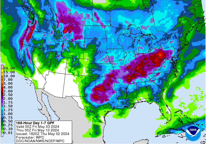
Garnetcat5 wrote:I thought there was a whole lot of dry air that was going to suppress it? What happened?
I don't know who said that or why, so you'd have to go back to where you thought you heard it and ask. If if was someone on here, you might want to include their name in the request. Here's the water vapor
https://www.tropicaltidbits.com/sat/sat ... uct=wv-mid
Here's the 7 day QPF forecast. It doesn't look particularly dry to me.
https://www.wpc.ncep.noaa.gov/qpf/p168i.gif?1568643638
1 likes
-
Garnetcat5
- Tropical Storm
- Posts: 196
- Joined: Wed Apr 23, 2003 8:19 am
- Location: Richmond, Tx
-
jasons2k

- Storm2k Executive
- Posts: 8072
- Age: 50
- Joined: Wed Jul 06, 2005 12:32 pm
- Location: The Woodlands, TX
Disturbed weather in GOM
Water vapor has been showing it entraining lots of dry air for days...that does suppress development... nevertheless, lots of rain on the way for Texas.
1 likes
-
captainbarbossa19

- Category 5

- Posts: 1039
- Joined: Wed Aug 21, 2019 11:09 pm
- Location: Starkville, MS
Re: Disturbed weather in GOM
MississippiWx wrote:HurricaneAndre2008 wrote:MississippiWx wrote:The curvature of the NW Gulf Coast is doing its work again. This looks like a TD this morning.
Is there any ascat that confirms this
Judging by the 8AM discussion from the NHC, they won't upgrade. It's not a big deal as it likely won't strengthen much past its current state, but still looks much more worthy than a 10% chance.
Seems like this system is going to have move rather quickly if it is going to move onshore by tonight or tomorrow morning. The only model I saw that moved the center onshore recently was the GFS. However, the latest model run shows it moving onshore on Wednesday morning. Also, I think the center is forming much further north than where the NHC currently has it tagged. However, maybe the NHC knows something that the models are not showing.
0 likes
-
wxman57

- Moderator-Pro Met

- Posts: 22480
- Age: 66
- Joined: Sat Jun 21, 2003 8:06 pm
- Location: Houston, TX (southwest)
Re: Disturbed weather in GOM
HurricaneAndre2008 wrote:MississippiWx wrote:The curvature of the NW Gulf Coast is doing its work again. This looks like a TD this morning.
Is there any ascat that confirms this
It's over an area with plenty of observations, which indicate a trof axis at the very least. ScatSat from last evening indicates a trof axis. I'm surprised the NHC only went 10%, myself. Might wander around off the TX coast until tomorrow night. I'm just hoping I get some rain in SW Houston. Severe drought. My rose bushes already died. Grass is dead. Trees suffering. Don't need 30", though...

4 likes

Re: Disturbed weather in GOM
Surface obs appear to support a weak, closed off surface low in the middle of the convection.
Est CoC 27.2N 94.4W
Est CoC 27.2N 94.4W
0 likes

Re: Disturbed weather in GOM
2 likes
Re: Disturbed weather in GOM
Station KVAF, the one with no wind barb is at 27.4N 94.6W
Looks like a tower is firing just to the NW of it.
Looks like a tower is firing just to the NW of it.
0 likes
Re: Disturbed weather in GOM
Station KHHV, south of the CoC reporting increasing west winds after a big shift earlier this morning.


0 likes
-
wxman57
- Moderator-Pro Met
- Posts: 22480
- Age: 66
- Joined: Sat Jun 21, 2003 8:06 pm
- Location: Houston, TX (southwest)
Re: Disturbed weather in GOM
GCANE wrote:Surface obs appear to support a weak, closed off surface low in the middle of the convection.
Est CoC 27.2N 94.4W
I'm seeing SW to NE moving low clouds well west of there, as far west as 95.4W. Looks more like a trof axis currently.
0 likes
Re: Disturbed weather in GOM
wxman57 wrote:GCANE wrote:Surface obs appear to support a weak, closed off surface low in the middle of the convection.
Est CoC 27.2N 94.4W
I'm seeing SW to NE moving low clouds well west of there, as far west as 95.4W. Looks more like a trof axis currently.
Where do you place the center?
0 likes
Personal Forecast Disclaimer:
The posts in this forum are NOT official forecast and should not be used as such. They are just the opinion of the poster and may or may not be backed by sound meteorological data. They are NOT endorsed by any professional institution or storm2k.org. For official information, please refer to the NHC and NWS products.
The posts in this forum are NOT official forecast and should not be used as such. They are just the opinion of the poster and may or may not be backed by sound meteorological data. They are NOT endorsed by any professional institution or storm2k.org. For official information, please refer to the NHC and NWS products.
Who is online
Users browsing this forum: Hurricaneman, NotSparta, pepecool20, revjohn, zzzh and 156 guests