2020 EPAC Season
Moderator: S2k Moderators
Forum rules

The posts in this forum are NOT official forecasts and should not be used as such. They are just the opinion of the poster and may or may not be backed by sound meteorological data. They are NOT endorsed by any professional institution or STORM2K. For official information, please refer to products from the National Hurricane Center and National Weather Service.
-
cycloneye

- Admin

- Posts: 139069
- Age: 67
- Joined: Thu Oct 10, 2002 10:54 am
- Location: San Juan, Puerto Rico
Re: 2020 EPAC Season
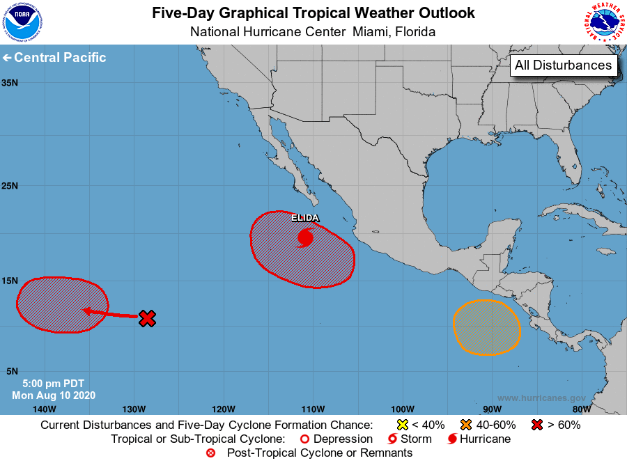
And now there are three besides Elida.

1. Disorganized showers and thunderstorms associated with a trough of
low pressure are located about 1500 miles west-southwest of the
southern tip of the Baja California peninsula. An area of low
pressure is expected to form from this system in a couple of days,
and it could become a tropical depression late this week. The
system is expected to move slowly westward toward the central
Pacific basin during the next several days.
* Formation chance through 48 hours...low...10 percent.
* Formation chance through 5 days...medium...60 percent.
2. An area of low pressure is forecast to develop well offshore
the southwestern coast of Mexico around the middle of the week.
Gradual development is possible thereafter, and this system could
also become a tropical depression by late this week while it moves
generally west-northwestward.
* Formation chance through 48 hours...low...near 0 percent.
* Formation chance through 5 days...medium...60 percent.
3. Another area of low pressure is expected to form by the end of the
week over the far eastern portion of the basin to the south of the
coast of Central America. Gradual development of this system is
possible this weekend while it moves generally west-northwestward.
* Formation chance through 48 hours...low...near 0 percent.
* Formation chance through 5 days...low...20 percent.
0 likes
Visit the Caribbean-Central America Weather Thread where you can find at first post web cams,radars
and observations from Caribbean basin members Click Here
and observations from Caribbean basin members Click Here

Re: 2020 EPAC Season
cycloneye wrote:And now there are three besides Elida.1. Disorganized showers and thunderstorms associated with a trough of
low pressure are located about 1500 miles west-southwest of the
southern tip of the Baja California peninsula. An area of low
pressure is expected to form from this system in a couple of days,
and it could become a tropical depression late this week. The
system is expected to move slowly westward toward the central
Pacific basin during the next several days.
* Formation chance through 48 hours...low...10 percent.
* Formation chance through 5 days...medium...60 percent.
2. An area of low pressure is forecast to develop well offshore
the southwestern coast of Mexico around the middle of the week.
Gradual development is possible thereafter, and this system could
also become a tropical depression by late this week while it moves
generally west-northwestward.
* Formation chance through 48 hours...low...near 0 percent.
* Formation chance through 5 days...medium...60 percent.
3. Another area of low pressure is expected to form by the end of the
week over the far eastern portion of the basin to the south of the
coast of Central America. Gradual development of this system is
possible this weekend while it moves generally west-northwestward.
* Formation chance through 48 hours...low...near 0 percent.
* Formation chance through 5 days...low...20 percent.
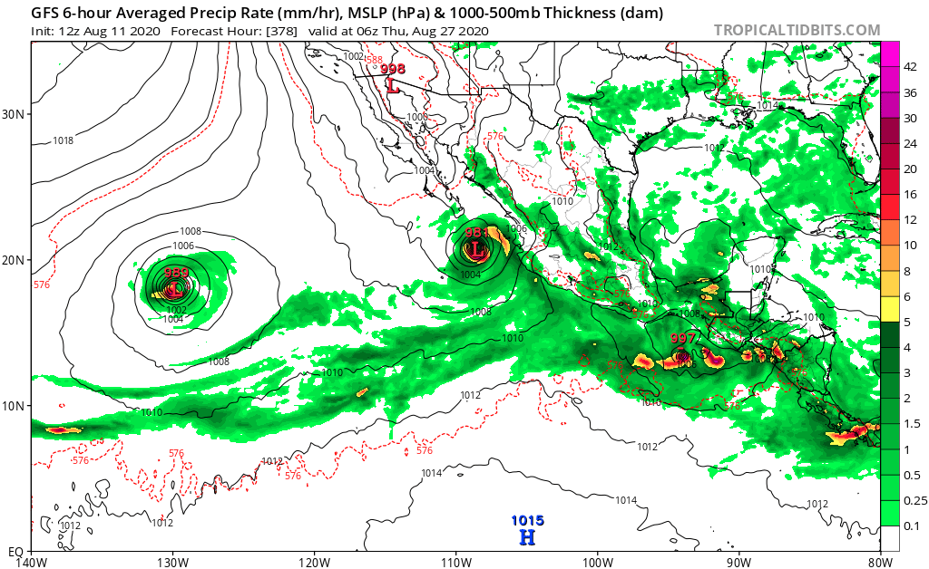
https://i.imgur.com/t5EwXHH.png
The 0/20 AOI is that potential major the GFS has been showing for a few days. I guess it’s not longer unlikely, since the NHC has noted it and the GFS is still very bullish. Part of the reason for the intense GFS runs is likely due to it starting at a low latitude and running parallel to the Mexican coast, right through the entire pocket of 29-30C SSTs.
0 likes
Irene '11 Sandy '12 Hermine '16 5/15/2018 Derecho Fay '20 Isaias '20 Elsa '21 Henri '21 Ida '21
I am only a meteorology enthusiast who knows a decent amount about tropical cyclones. Look to the professional mets, the NHC, or your local weather office for the best information.
I am only a meteorology enthusiast who knows a decent amount about tropical cyclones. Look to the professional mets, the NHC, or your local weather office for the best information.
-
EquusStorm

- Category 5

- Posts: 1649
- Age: 33
- Joined: Thu Nov 07, 2013 1:04 pm
- Location: Jasper, AL
- Contact:
Re: 2020 EPAC Season
I'm a little more inclined to believe this cluster of storms than the July cluster that failed to happen since the other globals are showing the exact same thing and subseasonal conditions look quite ripe for it to happen. Will probably be some eye candy to track coming up
1 likes
Colors of lost purpose on the canvas of irrelevance
Not a meteorologist, in fact more of an idiot than anything. You should probably check with the NHC or a local NWS office for official information.
Not a meteorologist, in fact more of an idiot than anything. You should probably check with the NHC or a local NWS office for official information.
-
gatorcane

- S2K Supporter

- Posts: 23499
- Age: 46
- Joined: Sun Mar 13, 2005 3:54 pm
- Location: Boca Raton, FL
Re: 2020 EPAC Season
Euro has this heading toward Baja and is stronger than the 00Z it looks like but not as strong as the GFS likely since it keeps it relatively closer to the coast.
0 likes
-
EquusStorm
- Category 5
- Posts: 1649
- Age: 33
- Joined: Thu Nov 07, 2013 1:04 pm
- Location: Jasper, AL
- Contact:
Re: 2020 EPAC Season
Let's hope everything stays far enough offshore Pacific Mexico to keep the heavier bands out to sea, as a train of several systems back to back would be catastrophic for flooding and mudslides if they're any closer than modeled to shore
0 likes
Colors of lost purpose on the canvas of irrelevance
Not a meteorologist, in fact more of an idiot than anything. You should probably check with the NHC or a local NWS office for official information.
Not a meteorologist, in fact more of an idiot than anything. You should probably check with the NHC or a local NWS office for official information.
-
Kingarabian

- S2K Supporter
- Posts: 15434
- Joined: Sat Aug 08, 2009 3:06 am
- Location: Honolulu, Hawaii
Re: 2020 EPAC Season
The area near 125W-130W needs to be tagged as an invest already.
0 likes
RIP Kobe Bryant
Re: 2020 EPAC Season
I’ve been skeptical of the three new EPac systems for the last several days, but now I’m fully on board. Model consensus has been excellent — GFS, GFS-Para, ECMWF, and CMC are all very close in their solutions of the 10/60 and 0/60 disturbances developing into modest TCs, and the 0/20 distance becoming a hurricane or a major as it parallels the Mexican coast. NAVGEM and ICON aren’t too fond of these, but they still show up, albeit very weak.
1 likes
Irene '11 Sandy '12 Hermine '16 5/15/2018 Derecho Fay '20 Isaias '20 Elsa '21 Henri '21 Ida '21
I am only a meteorology enthusiast who knows a decent amount about tropical cyclones. Look to the professional mets, the NHC, or your local weather office for the best information.
I am only a meteorology enthusiast who knows a decent amount about tropical cyclones. Look to the professional mets, the NHC, or your local weather office for the best information.
-
cycloneye
- Admin
- Posts: 139069
- Age: 67
- Joined: Thu Oct 10, 2002 10:54 am
- Location: San Juan, Puerto Rico
Re: 2020 EPAC Season
1. Disorganized showers and thunderstorms associated with a trough of
low pressure are centered about 1500 miles southwest of the
southern tip of the Baja California peninsula. An area of low
pressure is expected to form from this system in a day or two,
and it will likely become a tropical depression late this week.
The system is expected to move slowly westward toward the central
Pacific basin during the next several days.
* Formation chance through 48 hours...low...20 percent.
* Formation chance through 5 days...high...70 percent.
2. An area of low pressure is forecast to develop well offshore of
the southwestern coast of Mexico in a couple of days.
Environmental conditions appear conducive for development
thereafter, and this system will likely become a tropical depression
by late this week while it moves generally west-northwestward.
* Formation chance through 48 hours...low...near 0 percent.
* Formation chance through 5 days...high...70 percent.
3. Another area of low pressure is expected to form in a few days over
the far eastern portion of the basin to the south of the coast of
Central America. Gradual development of this system is possible,
and a tropical depression could form this weekend while it moves
generally west-northwestward.
* Formation chance through 48 hours...low...near 0 percent.
* Formation chance through 5 days...medium...40 percent.
0 likes
Visit the Caribbean-Central America Weather Thread where you can find at first post web cams,radars
and observations from Caribbean basin members Click Here
and observations from Caribbean basin members Click Here
Re: 2020 EPAC Season
0/40 is probably the best bet for another Big One in the EPac, one that officially exceeds 120 kt (Douglas was probably near Cat 5 status although the NHC only kept it at 115 kt). It will spend the most time over the warmest waters of any system that has so far formed in the basin this year, going through that coastal pocket of >29 C SSTs. It should remain in that region for several days, (hopefully) long enough for it to do something impressive before dry air wins.
0 likes
Irene '11 Sandy '12 Hermine '16 5/15/2018 Derecho Fay '20 Isaias '20 Elsa '21 Henri '21 Ida '21
I am only a meteorology enthusiast who knows a decent amount about tropical cyclones. Look to the professional mets, the NHC, or your local weather office for the best information.
I am only a meteorology enthusiast who knows a decent amount about tropical cyclones. Look to the professional mets, the NHC, or your local weather office for the best information.
-
Kingarabian
- S2K Supporter
- Posts: 15434
- Joined: Sat Aug 08, 2009 3:06 am
- Location: Honolulu, Hawaii
Re: 2020 EPAC Season
Models now don't move that 20/70 into the CPAC and actually keep it very weak.
0 likes
RIP Kobe Bryant
Re: 2020 EPAC Season
The 0/40 AOI still has a very good chance of becoming a powerful major hurricane. It looks like it will develop on Sunday, and its path will take it through the areas of the highest MPIs in the basin. Not only that, but it’ll be over those very warm waters for 4-6 days, plenty of time for it to overcome the struggles every EPac system has had this year and find time to bomb out. This is assuming it takes the same path off of the Mexican coast that the GFS/GFS-Para/ECMWF have shown for the last several days.
0 likes
Irene '11 Sandy '12 Hermine '16 5/15/2018 Derecho Fay '20 Isaias '20 Elsa '21 Henri '21 Ida '21
I am only a meteorology enthusiast who knows a decent amount about tropical cyclones. Look to the professional mets, the NHC, or your local weather office for the best information.
I am only a meteorology enthusiast who knows a decent amount about tropical cyclones. Look to the professional mets, the NHC, or your local weather office for the best information.
-
Yellow Evan

- Professional-Met

- Posts: 15951
- Age: 25
- Joined: Fri Jul 15, 2011 12:48 pm
- Location: Henderson, Nevada/Honolulu, HI
- Contact:
-
gatorcane
- S2K Supporter
- Posts: 23499
- Age: 46
- Joined: Sun Mar 13, 2005 3:54 pm
- Location: Boca Raton, FL
Re: 2020 EPAC Season
The GFS has the potential major down to 938MB south of Baja and keeps cranking out storm after storm with those above normal SSTs.
0 likes
-
SFLcane

- S2K Supporter
- Posts: 9606
- Age: 46
- Joined: Sat Jun 05, 2010 1:44 pm
- Location: Lake Worth Florida
Re: 2020 EPAC Season
gatorcane wrote:The GFS has the potential major down to 938MB south of Baja and keeps cranking out storm after storm with those above normal SSTs.
Thats expected with the MJO right over that area. That will be sliding eastward soon
0 likes
Re: 2020 EPAC Season
It’s pretty obvious the 2020 EPac season has fallen far behind the most recent seasons. Here’s a comparison of where 2020 stands among the last seven years, as of August 11th of each year.
2020: 5/2/1
—Strongest storm: Douglas, 115 kt/954 mbar
2019: 7/4/2
—Strongest storm: Barbara, 135 kt/930 mbar
2018: 11/5/3
—Strongest storm: Hector, 135 kt/936 mbar
2017: 10/5/2
—Strongest storm: Fernanda, 125 kt/948 mbar
2016: 11/6/3
—Strongest storm: Blas, 120 kt/947 mbar
2015: 11/6/4
—Strongest storm: Hilda, 125 kt/937 mbar
2014: 11/6/3
—Strongest storm: Amanda, 135 kt/932 mbar
2013: 8/6/0
—Strongest storm: Henriette, 90 kt/976 mbar
While 2020 isn’t as bad as 2013 when it comes to intense storms, it has fallen far behind 2014-18 in terms of named storms, hurricanes, and majors. It’s also behind 2019’s hurricanes and majors, and 2020’s most intense storm is weaker than all except for 2013. It’s safe to say this is one of the EPac’s worst performances in the last decade, but the basin could finally have some time to shine if the model predictions for multiple named storms and a major verify.
7 likes
Irene '11 Sandy '12 Hermine '16 5/15/2018 Derecho Fay '20 Isaias '20 Elsa '21 Henri '21 Ida '21
I am only a meteorology enthusiast who knows a decent amount about tropical cyclones. Look to the professional mets, the NHC, or your local weather office for the best information.
I am only a meteorology enthusiast who knows a decent amount about tropical cyclones. Look to the professional mets, the NHC, or your local weather office for the best information.
-
gatorcane
- S2K Supporter
- Posts: 23499
- Age: 46
- Joined: Sun Mar 13, 2005 3:54 pm
- Location: Boca Raton, FL
Re: 2020 EPAC Season
The GFS continues to crank out storm after storm in the EPAC with no end in sight. Here is how the run ends.
It is not as strong with the potential major in 8-10 days due to land proximity it appears.
It is not as strong with the potential major in 8-10 days due to land proximity it appears.
0 likes
-
CyclonicFury

- Category 5
- Posts: 1975
- Age: 25
- Joined: Sun Jul 02, 2017 12:32 pm
- Location: NC
- Contact:
Re: 2020 EPAC Season
gatorcane wrote:The GFS continues to crank out storm after storm in the EPAC with no end in sight. Here is how the run ends.
https://i.postimg.cc/fyDK5nfG/gfs-mslp-pcpn-epac-63.png
It is not as strong with the potential major in 8-10 days due to land proximity it appears.
I have a hard time believing the EPAC will continue to crank out hurricane after hurricane in late August while the Atlantic is dead, when the Atlantic base state is much more favorable than the EPAC. The GFS has a bias in keeping the MJO in Phase 8 too long. Regardless, next 10 days look very active in the EPAC.
4 likes
NCSU B.S. in Meteorology Class of 2021. Tropical weather blogger at http://www.cyclonicfury.com. My forecasts and thoughts are NOT official, for official forecasts please consult the National Hurricane Center.
-
cycloneye
- Admin
- Posts: 139069
- Age: 67
- Joined: Thu Oct 10, 2002 10:54 am
- Location: San Juan, Puerto Rico
Re: 2020 EPAC Season
2. An area of disturbed weather is located a few hundred miles south-
southwest of the Gulf of Tehuantepec. An area of low pressure is
forecast to develop from this system well south or southwest of the
southwestern coast of Mexico in a couple of days. Environmental
conditions appear conducive for development thereafter, and this
system will likely become a tropical depression late this week or
over the weekend while it moves generally west-northwestward.
* Formation chance through 48 hours...low...20 percent.
* Formation chance through 5 days...high...80 percent.
3. Another area of low pressure is expected to form in a few days over
the far eastern portion of the basin to the south of the coast of
Central America. Gradual development of this system is possible, and
a tropical depression could form this weekend while it moves
generally west-northwestward.
* Formation chance through 48 hours...low...near 0 percent.
* Formation chance through 5 days...medium...40 percent.
0 likes
Visit the Caribbean-Central America Weather Thread where you can find at first post web cams,radars
and observations from Caribbean basin members Click Here
and observations from Caribbean basin members Click Here
Who is online
Users browsing this forum: cheezyWXguy, Lizzytiz1 and 194 guests