2020 Indicators: SST's / SAL / MSLP / Steering / Shear / Instability / Sat Images

This is the general tropical discussion area. Anyone can take their shot at predicting a storms path.

Moderator: S2k Moderators

Forum rules

The posts in this forum are NOT official forecasts and should not be used as such. They are just the opinion of the poster and may or may not be backed by sound meteorological data. They are NOT endorsed by any professional institution or STORM2K. For official information, please refer to products from the National Hurricane Center and National Weather Service.

Help Support Storm2K
Message
Author
User avatar
toad strangler
S2K Supporter
S2K Supporter
Posts: 4163
Joined: Sun Jul 28, 2013 3:09 pm
Location: Earth
Contact:

Re: 2020 Indicators: SST's / SAL / MSLP / Steering / Shear / Instability / Sat Images

#3261 Postby toad strangler » Tue Oct 06, 2020 9:00 pm

gatorcane wrote:Despite this record-breaking season, there is noticeable lack of anything significant so far in the area I circled which ironically is probably the most vulnerable to hurricanes which includes peninsula Florida, the islands and the area south of Bermuda in the SW Atlantic. Isaias and Laura did move through this area but were not high impact wind storms:

https://i.postimg.cc/T2FFmf0x/DEA969-D3-CB1-C-42-BF-8-EDD-22404-AA816-EA.jpg


That's the tropics being the tropics!
1 likes   

User avatar
TheStormExpert
Category 5
Category 5
Posts: 8487
Age: 30
Joined: Wed Feb 16, 2011 5:38 pm
Location: Palm Beach Gardens, FL

Re: 2020 Indicators: SST's / SAL / MSLP / Steering / Shear / Instability / Sat Images

#3262 Postby TheStormExpert » Tue Oct 06, 2020 9:09 pm

gatorcane wrote:Despite this record-breaking season, there is noticeable lack of anything significant so far in the area I circled which ironically is probably the most vulnerable to hurricanes which includes peninsula Florida, the islands and the area south of Bermuda in the SW Atlantic. Isaias and Laura did move through this area but were not high impact wind storms:

https://i.postimg.cc/T2FFmf0x/DEA969-D3-CB1-C-42-BF-8-EDD-22404-AA816-EA.jpg

Well at least this is good news for places such as The Abacos and Grand Bahamas Island that suffered severely from Dorian last year.

As for the Florida peninsula we just keep getting real lucky outside of Irma in 2017 which wasn’t as bad as originally forecasted to be, especially for SE Florida.
0 likes   
The following post is NOT an official forecast and should not be used as such. It is just the opinion of the poster and may or may not be backed by sound meteorological data. It is NOT endorsed by storm2k.org.

User avatar
toad strangler
S2K Supporter
S2K Supporter
Posts: 4163
Joined: Sun Jul 28, 2013 3:09 pm
Location: Earth
Contact:

Re: 2020 Indicators: SST's / SAL / MSLP / Steering / Shear / Instability / Sat Images

#3263 Postby toad strangler » Tue Oct 06, 2020 9:16 pm

TheStormExpert wrote:
gatorcane wrote:Despite this record-breaking season, there is noticeable lack of anything significant so far in the area I circled which ironically is probably the most vulnerable to hurricanes which includes peninsula Florida, the islands and the area south of Bermuda in the SW Atlantic. Isaias and Laura did move through this area but were not high impact wind storms:

https://i.postimg.cc/T2FFmf0x/DEA969-D3-CB1-C-42-BF-8-EDD-22404-AA816-EA.jpg

Well at least this is good news for places such as The Abacos and Grand Bahamas Island that suffered severely from Dorian last year.

As for the Florida peninsula we just keep getting real lucky outside of Irma in 2017 which wasn’t as bad as originally forecasted to be, especially for SE Florida.


Irma was plenty bad for the Keys and and the SW peninsula where it actually hit. I work in the roofing industry and rest assured it caused havoc. It was NOT a miss by any stretch. To you in the urban center of SE FL it was a very close miss.
2 likes   

User avatar
ElectricStorm
Category 5
Category 5
Posts: 4575
Age: 23
Joined: Tue Aug 13, 2019 11:23 pm
Location: Skiatook, OK / Norman, OK

Re: 2020 Indicators: SST's / SAL / MSLP / Steering / Shear / Instability / Sat Images

#3264 Postby ElectricStorm » Tue Oct 06, 2020 9:21 pm

toad strangler wrote:
TheStormExpert wrote:
gatorcane wrote:Despite this record-breaking season, there is noticeable lack of anything significant so far in the area I circled which ironically is probably the most vulnerable to hurricanes which includes peninsula Florida, the islands and the area south of Bermuda in the SW Atlantic. Isaias and Laura did move through this area but were not high impact wind storms:

https://i.postimg.cc/T2FFmf0x/DEA969-D3-CB1-C-42-BF-8-EDD-22404-AA816-EA.jpg

Well at least this is good news for places such as The Abacos and Grand Bahamas Island that suffered severely from Dorian last year.

As for the Florida peninsula we just keep getting real lucky outside of Irma in 2017 which wasn’t as bad as originally forecasted to be, especially for SE Florida.


Irma was plenty bad for the Keys and and the SW peninsula where it actually hit. I work in the roofing industry and rest assured it caused havoc. It was NOT a miss by any stretch. To you in the urban center of SE FL it was a very close miss.

Yeah I agree. What people call SE Florida on here is such a small area, it's like picking a random point in the Atlantic and counting storms that hit that exact spot. Irma was a direct hit on S Florida so I'm not sure why people don't count that. I get that it didn't hit the most populated areas down there but I don't understand how people just dismiss it when it comes to talking about the "shield" Florida has
4 likes   
I am in no way a professional. Take what I say with a grain of salt as I could be totally wrong. Please refer to the NHC, NWS, or SPC for official information.

Boomer Sooner!

User avatar
TheStormExpert
Category 5
Category 5
Posts: 8487
Age: 30
Joined: Wed Feb 16, 2011 5:38 pm
Location: Palm Beach Gardens, FL

Re: 2020 Indicators: SST's / SAL / MSLP / Steering / Shear / Instability / Sat Images

#3265 Postby TheStormExpert » Tue Oct 06, 2020 9:31 pm

toad strangler wrote:
TheStormExpert wrote:
gatorcane wrote:Despite this record-breaking season, there is noticeable lack of anything significant so far in the area I circled which ironically is probably the most vulnerable to hurricanes which includes peninsula Florida, the islands and the area south of Bermuda in the SW Atlantic. Isaias and Laura did move through this area but were not high impact wind storms:

https://i.postimg.cc/T2FFmf0x/DEA969-D3-CB1-C-42-BF-8-EDD-22404-AA816-EA.jpg

Well at least this is good news for places such as The Abacos and Grand Bahamas Island that suffered severely from Dorian last year.

As for the Florida peninsula we just keep getting real lucky outside of Irma in 2017 which wasn’t as bad as originally forecasted to be, especially for SE Florida.


Irma was plenty bad for the Keys and and the SW peninsula where it actually hit. I work in the roofing industry and rest assured it caused havoc. It was NOT a miss by any stretch. To you in the urban center of SE FL it was a very close miss.

It was originally forecasted to be an intense Cat.4 strike on metropolitan SE Florida. But overall the peninsula has done well since the dreaded 2004 season with only Wilma and Irma being significant impacting threats.
0 likes   
The following post is NOT an official forecast and should not be used as such. It is just the opinion of the poster and may or may not be backed by sound meteorological data. It is NOT endorsed by storm2k.org.

User avatar
TheStormExpert
Category 5
Category 5
Posts: 8487
Age: 30
Joined: Wed Feb 16, 2011 5:38 pm
Location: Palm Beach Gardens, FL

Re: 2020 Indicators: SST's / SAL / MSLP / Steering / Shear / Instability / Sat Images

#3266 Postby TheStormExpert » Tue Oct 06, 2020 9:34 pm

Weather Dude wrote:
toad strangler wrote:
TheStormExpert wrote:Well at least this is good news for places such as The Abacos and Grand Bahamas Island that suffered severely from Dorian last year.

As for the Florida peninsula we just keep getting real lucky outside of Irma in 2017 which wasn’t as bad as originally forecasted to be, especially for SE Florida.


Irma was plenty bad for the Keys and and the SW peninsula where it actually hit. I work in the roofing industry and rest assured it caused havoc. It was NOT a miss by any stretch. To you in the urban center of SE FL it was a very close miss.

Yeah I agree. What people call SE Florida on here is such a small area, it's like picking a random point in the Atlantic and counting storms that hit that exact spot. Irma was a direct hit on S Florida so I'm not sure why people don't count that. I get that it didn't hit the most populated areas down there but I don't understand how people just dismiss it when it comes to talking about the "shield" Florida has

SE Florida has the highest property retail value of any portion of this state! So any kind of major hurricane impact on this portion would be beyond catastrophic. Not to mention we have a much shorter hurricane return period when compared to places like NE Florida, the panhandle, or the west coast of Florida.
0 likes   
The following post is NOT an official forecast and should not be used as such. It is just the opinion of the poster and may or may not be backed by sound meteorological data. It is NOT endorsed by storm2k.org.

User avatar
ElectricStorm
Category 5
Category 5
Posts: 4575
Age: 23
Joined: Tue Aug 13, 2019 11:23 pm
Location: Skiatook, OK / Norman, OK

Re: 2020 Indicators: SST's / SAL / MSLP / Steering / Shear / Instability / Sat Images

#3267 Postby ElectricStorm » Tue Oct 06, 2020 9:40 pm

TheStormExpert wrote:
Weather Dude wrote:
toad strangler wrote:
Irma was plenty bad for the Keys and and the SW peninsula where it actually hit. I work in the roofing industry and rest assured it caused havoc. It was NOT a miss by any stretch. To you in the urban center of SE FL it was a very close miss.

Yeah I agree. What people call SE Florida on here is such a small area, it's like picking a random point in the Atlantic and counting storms that hit that exact spot. Irma was a direct hit on S Florida so I'm not sure why people don't count that. I get that it didn't hit the most populated areas down there but I don't understand how people just dismiss it when it comes to talking about the "shield" Florida has

SE Florida has the highest property retail value of any portion of this state! So any kind of major hurricane impact on this portion would be beyond catastrophic. Not to mention we have a much shorter hurricane return period when compared to places like NE Florida, the panhandle, or the west coast of Florida.

Yeah I get that, but it just seems weird that people treat Irma like it never even came close to them when in reality it barely missed. But I'm not even from Florida, never even been there so what do I know lol
4 likes   
I am in no way a professional. Take what I say with a grain of salt as I could be totally wrong. Please refer to the NHC, NWS, or SPC for official information.

Boomer Sooner!

User avatar
TheStormExpert
Category 5
Category 5
Posts: 8487
Age: 30
Joined: Wed Feb 16, 2011 5:38 pm
Location: Palm Beach Gardens, FL

Re: 2020 Indicators: SST's / SAL / MSLP / Steering / Shear / Instability / Sat Images

#3268 Postby TheStormExpert » Tue Oct 06, 2020 9:42 pm

Weather Dude wrote:
TheStormExpert wrote:
Weather Dude wrote:Yeah I agree. What people call SE Florida on here is such a small area, it's like picking a random point in the Atlantic and counting storms that hit that exact spot. Irma was a direct hit on S Florida so I'm not sure why people don't count that. I get that it didn't hit the most populated areas down there but I don't understand how people just dismiss it when it comes to talking about the "shield" Florida has

SE Florida has the highest property retail value of any portion of this state! So any kind of major hurricane impact on this portion would be beyond catastrophic. Not to mention we have a much shorter hurricane return period when compared to places like NE Florida, the panhandle, or the west coast of Florida.

Yeah I get that, but it just seems weird that people treat Irma like it never even came close to them when in reality it barely missed. But I'm not even from Florida, never even been there so what do I know lol

Yes, it barely missed and was the most eventful storm out of it Matthew, and Dorian. But metropolitan SE Florida only had hurricane wind gusts with sustained TS winds. No sustained hurricane winds.
0 likes   
The following post is NOT an official forecast and should not be used as such. It is just the opinion of the poster and may or may not be backed by sound meteorological data. It is NOT endorsed by storm2k.org.

User avatar
toad strangler
S2K Supporter
S2K Supporter
Posts: 4163
Joined: Sun Jul 28, 2013 3:09 pm
Location: Earth
Contact:

Re: 2020 Indicators: SST's / SAL / MSLP / Steering / Shear / Instability / Sat Images

#3269 Postby toad strangler » Tue Oct 06, 2020 9:47 pm

TheStormExpert wrote:
Weather Dude wrote:
toad strangler wrote:
Irma was plenty bad for the Keys and and the SW peninsula where it actually hit. I work in the roofing industry and rest assured it caused havoc. It was NOT a miss by any stretch. To you in the urban center of SE FL it was a very close miss.

Yeah I agree. What people call SE Florida on here is such a small area, it's like picking a random point in the Atlantic and counting storms that hit that exact spot. Irma was a direct hit on S Florida so I'm not sure why people don't count that. I get that it didn't hit the most populated areas down there but I don't understand how people just dismiss it when it comes to talking about the "shield" Florida has

SE Florida has the highest property retail value of any portion of this state! So any kind of major hurricane impact on this portion would be beyond catastrophic. Noyt to mention we have a much shorter hurricane return period when compared to places like NE Florida, the panhandle, or the west coast of Florida.


"Beyond catastrophic" is sensationalism in my view. S FL has had the most stringent building codes in the nation in recent memory and does nothing but continue to fortify with new construction and remodeling of older structures.. I am confident the area will hold up much better than many anticipate.
0 likes   

tolakram
Admin
Admin
Posts: 19165
Age: 60
Joined: Sun Aug 27, 2006 8:23 pm
Location: Florence, KY (name is Mark)

Re: 2020 Indicators: SST's / SAL / MSLP / Steering / Shear / Instability / Sat Images

#3270 Postby tolakram » Wed Oct 07, 2020 6:10 am

First we go years without a major and end up having these constant arguments about majors never hitting the US again (yea, it happened). Now it's they didn't hit in the 'right place' and even some have gone as far as claiming Florida is protected (yea, it happened).

My point of view is every season is different, and while the odds of some locations getting hit over others might be higher, or seem higher, I'm not sure how factual it is. For Florida to get hit from the east you need a storm in just the right location and a ridge just weak enough to not drive the storm too far south, but not so weak that it recurves up the coast. I see east coast Florida hits as rare, and I'm not sure why it comes up every season.

Image

What am I missing?
6 likes   
M a r k
- - - - -
Join us in chat: Storm2K Chatroom Invite. Android and IOS apps also available.

The posts in this forum are NOT official forecasts and should not be used as such. Posts are NOT endorsed by any professional institution or STORM2K.org. For official information and forecasts, please refer to NHC and NWS products.

User avatar
toad strangler
S2K Supporter
S2K Supporter
Posts: 4163
Joined: Sun Jul 28, 2013 3:09 pm
Location: Earth
Contact:

Re: 2020 Indicators: SST's / SAL / MSLP / Steering / Shear / Instability / Sat Images

#3271 Postby toad strangler » Wed Oct 07, 2020 8:10 am

tolakram wrote:First we go years without a major and end up having these constant arguments about majors never hitting the US again (yea, it happened). Now it's they didn't hit in the 'right place' and even some have gone as far as claiming Florida is protected (yea, it happened).

My point of view is every season is different, and while the odds of some locations getting hit over others might be higher, or seem higher, I'm not sure how factual it is. For Florida to get hit from the east you need a storm in just the right location and a ridge just weak enough to not drive the storm too far south, but not so weak that it recurves up the coast. I see east coast Florida hits as rare, and I'm not sure why it comes up every season.

https://i.imgur.com/zDocBuD.jpg

What am I missing?


Well the only thing I would use to counter the East Coast FL rare tag is that the historic return rate is among the lowest(most frequent) in the CONUS for a Cat 1 Minimum in Palm Beach, Broward, and Dade counties. Right up there with the Central Gulf Coast and NC / Outer Banks.

EDITED to add that this return rate is from the NOAA and includes a 100 year average. Honestly I think that 100 years is even too small of a sample size let alone 57 years shown in the map posted. I'd love to see what a accurate 500 year map looks like ....

https://www.nhc.noaa.gov/climo/#returns
3 likes   

User avatar
TheStormExpert
Category 5
Category 5
Posts: 8487
Age: 30
Joined: Wed Feb 16, 2011 5:38 pm
Location: Palm Beach Gardens, FL

Re: 2020 Indicators: SST's / SAL / MSLP / Steering / Shear / Instability / Sat Images

#3272 Postby TheStormExpert » Wed Oct 07, 2020 11:03 am

Here’s some graphics to show that Florida is one of the hurricane hit hotspots along with the Carolinas and the Northern Gulf Coast. Being SE Florida’s last hurricane strike was Katrina in 2005, we are way overdue! Not to mention Andrew in 1992 was the last major hurricane strike in SE Florida.

Image

Image

Image

Image
2 likes   
The following post is NOT an official forecast and should not be used as such. It is just the opinion of the poster and may or may not be backed by sound meteorological data. It is NOT endorsed by storm2k.org.

User avatar
toad strangler
S2K Supporter
S2K Supporter
Posts: 4163
Joined: Sun Jul 28, 2013 3:09 pm
Location: Earth
Contact:

Re: 2020 Indicators: SST's / SAL / MSLP / Steering / Shear / Instability / Sat Images

#3273 Postby toad strangler » Wed Oct 07, 2020 11:07 am

TheStormExpert wrote:Here’s some graphics to show that Florida is one of the hurricane hit hotspots along with the Carolinas and the Northern Gulf Coast. Being SE Florida’s last hurricane strike was Katrina in 2005, we are way overdue! Not to mention Andrew in 1992 was the last major hurricane strike in SE Florida.


Those are all right in the link I provided in my last post!

The caveat here though is those return maps don't necessarily mean landfalls. The return rate uses WITHIN 50 miles as a strike.
So for instance, Matthew was a strike for much of the FL East Coast even though he stayed offshore. Thus, you aren't as overdue as you think you are :wink:
3 likes   

psyclone
S2K Supporter
S2K Supporter
Posts: 4488
Joined: Wed Aug 24, 2005 9:04 pm
Location: palm harbor fl

Re: 2020 Indicators: SST's / SAL / MSLP / Steering / Shear / Instability / Sat Images

#3274 Postby psyclone » Wed Oct 07, 2020 11:16 am

Low hurricane strike frequency was one of my factors in deciding to locate to the Tampa Bay area. So far it's working well.
3 likes   

tolakram
Admin
Admin
Posts: 19165
Age: 60
Joined: Sun Aug 27, 2006 8:23 pm
Location: Florence, KY (name is Mark)

Re: 2020 Indicators: SST's / SAL / MSLP / Steering / Shear / Instability / Sat Images

#3275 Postby tolakram » Wed Oct 07, 2020 12:06 pm

toad strangler wrote:
TheStormExpert wrote:Here’s some graphics to show that Florida is one of the hurricane hit hotspots along with the Carolinas and the Northern Gulf Coast. Being SE Florida’s last hurricane strike was Katrina in 2005, we are way overdue! Not to mention Andrew in 1992 was the last major hurricane strike in SE Florida.


Those are all right in the link I provided in my last post!

The caveat here though is those return maps don't necessarily mean landfalls. The return rate uses WITHIN 50 miles as a strike.
So for instance, Matthew was a strike for much of the FL East Coast even though he stayed offshore. Thus, you aren't as overdue as you think you are :wink:


Right, I want storms where actual landfall happened. I see that as part of the amateur observation problem. If it doesn't look like a classic hurricane then something is wrong, and if it doesn't make landfall then it missed. Statistics all seem to go by affected, not actual landfalls. edit: The map I showed were strikes, and I think it's fair to say if a hurricane doesn't strike an area most consider it a miss.
3 likes   
M a r k
- - - - -
Join us in chat: Storm2K Chatroom Invite. Android and IOS apps also available.

The posts in this forum are NOT official forecasts and should not be used as such. Posts are NOT endorsed by any professional institution or STORM2K.org. For official information and forecasts, please refer to NHC and NWS products.

User avatar
toad strangler
S2K Supporter
S2K Supporter
Posts: 4163
Joined: Sun Jul 28, 2013 3:09 pm
Location: Earth
Contact:

Re: 2020 Indicators: SST's / SAL / MSLP / Steering / Shear / Instability / Sat Images

#3276 Postby toad strangler » Wed Oct 07, 2020 2:48 pm

tolakram wrote:
toad strangler wrote:
TheStormExpert wrote:Here’s some graphics to show that Florida is one of the hurricane hit hotspots along with the Carolinas and the Northern Gulf Coast. Being SE Florida’s last hurricane strike was Katrina in 2005, we are way overdue! Not to mention Andrew in 1992 was the last major hurricane strike in SE Florida.


Those are all right in the link I provided in my last post!

The caveat here though is those return maps don't necessarily mean landfalls. The return rate uses WITHIN 50 miles as a strike.
So for instance, Matthew was a strike for much of the FL East Coast even though he stayed offshore. Thus, you aren't as overdue as you think you are :wink:


Right, I want storms where actual landfall happened. I see that as part of the amateur observation problem. If it doesn't look like a classic hurricane then something is wrong, and if it doesn't make landfall then it missed. Statistics all seem to go by affected, not actual landfalls. edit: The map I showed were strikes, and I think it's fair to say if a hurricane doesn't strike an area most consider it a miss.


NOAA clearly states the map intent on the their site but they don't put it on the actual graphic. So the map gets saved and pasted all over the place without the pertinent information like it was above on this page. Which is ......

"Estimated return period in years for hurricanes passing
within 50 nautical miles of various locations on the U.S. Coast"

It would help the mis read issues a ton if that was somewhere on the graphic!
0 likes   

User avatar
aspen
Category 5
Category 5
Posts: 8057
Joined: Sat Oct 12, 2019 7:10 pm
Location: Connecticut, USA

Re: 2020 Indicators: SST's / SAL / MSLP / Steering / Shear / Instability / Sat Images

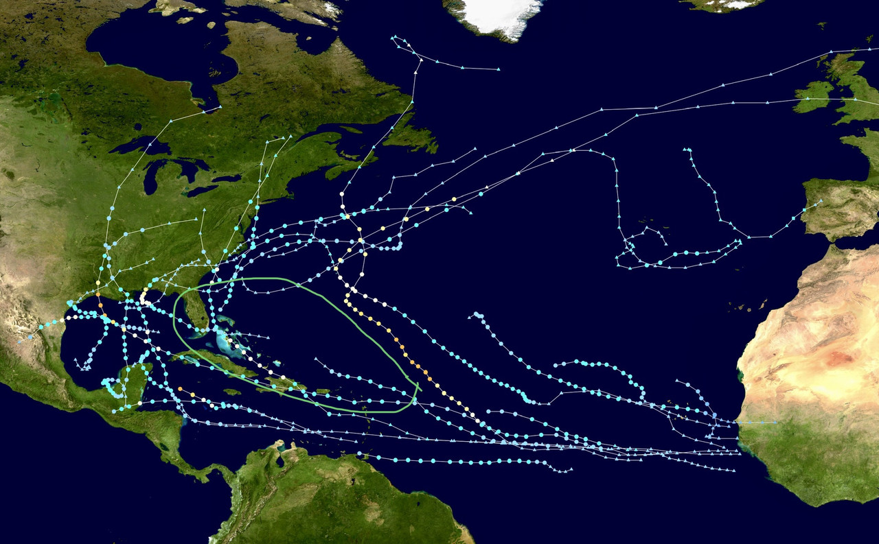
#3277 Postby aspen » Wed Oct 07, 2020 8:03 pm

I can’t believe how insanely active the Gulf has been this year. I know most of us were expecting a generally west-focused season, but wow, the Gulf has been a near record hot spot for activity. Cristobal, Hanna, Laura, Marco, Sally, Beta, and now Delta have all intensified in the Gulf and impacted somewhere on the coast, and there have been so many storms that there’ll probably be almost no ocean heat left to support anything once Delta is finished. It’s like this season is using every last drop of potential the Gulf has. Hopefully Delta will be the last storm there for this season, and thanks to the cold front, there won’t by any more RI hurricane landfalls like Hanna, Laura, and Sally.
3 likes   
Irene '11 Sandy '12 Hermine '16 5/15/2018 Derecho Fay '20 Isaias '20 Elsa '21 Henri '21 Ida '21

I am only a meteorology enthusiast who knows a decent amount about tropical cyclones. Look to the professional mets, the NHC, or your local weather office for the best information.

User avatar
ElectricStorm
Category 5
Category 5
Posts: 4575
Age: 23
Joined: Tue Aug 13, 2019 11:23 pm
Location: Skiatook, OK / Norman, OK

Re: 2020 Indicators: SST's / SAL / MSLP / Steering / Shear / Instability / Sat Images

#3278 Postby ElectricStorm » Wed Oct 07, 2020 8:06 pm

aspen wrote:I can’t believe how insanely active the Gulf has been this year. I know most of us were expecting a generally west-focused season, but wow, the Gulf has been a near record hot spot for activity. Cristobal, Hanna, Laura, Marco, Sally, Beta, and now Delta have all intensified in the Gulf and impacted somewhere on the coast, and there have been so many storms that there’ll probably be almost no ocean heat left to support anything once Delta is finished. It’s like this season is using every last drop of potential the Gulf has. Hopefully Delta will be the last storm there for this season, and thanks to the cold front, there won’t by any more RI hurricane landfalls like Hanna, Laura, and Sally.

It's crazy how Delta will be the record 10th CONUS landfall this season. And the 5th hurricane... Just ready for the season to be over... 2021 can't get here soon enough... For many reasons. Also, the gulf has had so many storms that the "2020 Gulf of Mexico Hurricane Season" could probably have it's own Wikipedia page now lol
3 likes   
I am in no way a professional. Take what I say with a grain of salt as I could be totally wrong. Please refer to the NHC, NWS, or SPC for official information.

Boomer Sooner!

User avatar
CyclonicFury
Category 5
Category 5
Posts: 1975
Age: 25
Joined: Sun Jul 02, 2017 12:32 pm
Location: NC
Contact:

Re: 2020 Indicators: SST's / SAL / MSLP / Steering / Shear / Instability / Sat Images

#3279 Postby CyclonicFury » Thu Oct 08, 2020 11:39 am

If Delta makes landfall in the US as a hurricane as currently expected, it will be the 10th U.S. TS+ landfall, which breaks the record set in 1916. It will also mean that there has been at least one TS+ US landfall in every month from May to October, and at least one US hurricane landfall in each month from July to October (I know 2005 pulled this off, not sure about other seasons).
5 likes   
NCSU B.S. in Meteorology Class of 2021. Tropical weather blogger at http://www.cyclonicfury.com. My forecasts and thoughts are NOT official, for official forecasts please consult the National Hurricane Center.

User avatar
Ryxn
Category 1
Category 1
Posts: 314
Age: 24
Joined: Fri Sep 08, 2017 4:50 pm
Location: Toronto, Canada

Re: 2020 Indicators: SST's / SAL / MSLP / Steering / Shear / Instability / Sat Images

#3280 Postby Ryxn » Thu Oct 08, 2020 6:11 pm

aspen wrote:I can’t believe how insanely active the Gulf has been this year. I know most of us were expecting a generally west-focused season, but wow, the Gulf has been a near record hot spot for activity. Cristobal, Hanna, Laura, Marco, Sally, Beta, and now Delta have all intensified in the Gulf and impacted somewhere on the coast, and there have been so many storms that there’ll probably be almost no ocean heat left to support anything once Delta is finished. It’s like this season is using every last drop of potential the Gulf has. Hopefully Delta will be the last storm there for this season, and thanks to the cold front, there won’t by any more RI hurricane landfalls like Hanna, Laura, and Sally.


Unfortunately, I don't think it will be the last storm...
0 likes   


Return to “Talkin' Tropics”

Who is online

Users browsing this forum: No registered users and 157 guests