2020 Indicators: SST's / SAL / MSLP / Steering / Shear / Instability / Sat Images

This is the general tropical discussion area. Anyone can take their shot at predicting a storms path.

Moderator: S2k Moderators

Forum rules

The posts in this forum are NOT official forecasts and should not be used as such. They are just the opinion of the poster and may or may not be backed by sound meteorological data. They are NOT endorsed by any professional institution or STORM2K. For official information, please refer to products from the National Hurricane Center and National Weather Service.

Help Support Storm2K
Message
Author
User avatar
TheStormExpert
Category 5
Category 5
Posts: 8487
Age: 30
Joined: Wed Feb 16, 2011 5:38 pm
Location: Palm Beach Gardens, FL

Re: 2020 Indicators: SST's / SAL / MSLP / Steering / Shear / Instability / Sat Images

#81 Postby TheStormExpert » Fri Mar 13, 2020 3:47 pm

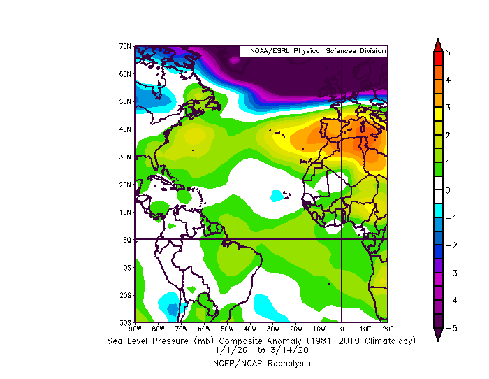
ScottNAtlanta wrote:This is not looking like a developing -AMO. If the area north of the islands continue to cool, you might get just the opposite. Warm over cool over warm. North Atlantic Tripole. That's also some really warm water off Africa. If there is a +WAM along with a stubborn +NAO you are going to see some long track storms this season

https://www.ospo.noaa.gov/data/sst/anomaly/2020/anomg.3.12.2020.gif

It’s only mid-March but I see what you’re saying. Several on here are already claiming a below-average season just because of the ever so persistent +NAO bringing dust, dry, and stable air into the MDR and Tropical Atlantic. But the last two seasons have proven that doesn’t mean season cancel. If anything it means more of a concern to the Caribbean, and U.S. in terms of delayed development like we saw with Dorian late last August.
0 likes   
The following post is NOT an official forecast and should not be used as such. It is just the opinion of the poster and may or may not be backed by sound meteorological data. It is NOT endorsed by storm2k.org.

User avatar
CyclonicFury
Category 5
Category 5
Posts: 1975
Age: 25
Joined: Sun Jul 02, 2017 12:32 pm
Location: NC
Contact:

Re: 2020 Indicators: SST's / SAL / MSLP / Steering / Shear / Instability / Sat Images

#82 Postby CyclonicFury » Fri Mar 13, 2020 4:02 pm

I disagree with predictions of a hostile MDR. The West African Monsoon (WAM) has been strong for several years now, enhancing AEW activity. There was a lot of talk about how unfavorable the MDR would be the past two seasons but neither year was particularly quiet in the eastern half of the MDR.

The ECMWF, which has been consistently forecasting a very dry MDR the last few years, is showing near-normal precipitation in the MDR and Caribbean for JAS. Most of the other models are showing a wetter than normal MDR.
8 likes   
NCSU B.S. in Meteorology Class of 2021. Tropical weather blogger at http://www.cyclonicfury.com. My forecasts and thoughts are NOT official, for official forecasts please consult the National Hurricane Center.

User avatar
TheStormExpert
Category 5
Category 5
Posts: 8487
Age: 30
Joined: Wed Feb 16, 2011 5:38 pm
Location: Palm Beach Gardens, FL

Re: 2020 Indicators: SST's / SAL / MSLP / Steering / Shear / Instability / Sat Images

#83 Postby TheStormExpert » Fri Mar 13, 2020 5:53 pm

CyclonicFury wrote:I disagree with predictions of a hostile MDR. The West African Monsoon (WAM) has been strong for several years now, enhancing AEW activity. There was a lot of talk about how unfavorable the MDR would be the past two seasons but neither year was particularly quiet in the eastern half of the MDR.

The ECMWF, which has been consistently forecasting a very dry MDR the last few years, is showing near-normal precipitation in the MDR and Caribbean for JAS. Most of the other models are showing a wetter than normal MDR.

Couldn’t agree more about the MDR being quite favorable the last two seasons considering the state of the ENSO the last two seasons. Maybe we should throw in 2010 as a potential analog season for the time being?
1 likes   
The following post is NOT an official forecast and should not be used as such. It is just the opinion of the poster and may or may not be backed by sound meteorological data. It is NOT endorsed by storm2k.org.

Chris90
Category 2
Category 2
Posts: 637
Age: 34
Joined: Thu Jun 01, 2017 9:36 pm

Re: 2020 Indicators: SST's / SAL / MSLP / Steering / Shear / Instability / Sat Images

#84 Postby Chris90 » Mon Mar 16, 2020 12:19 am

TheStormExpert wrote:
CyclonicFury wrote:I disagree with predictions of a hostile MDR. The West African Monsoon (WAM) has been strong for several years now, enhancing AEW activity. There was a lot of talk about how unfavorable the MDR would be the past two seasons but neither year was particularly quiet in the eastern half of the MDR.

The ECMWF, which has been consistently forecasting a very dry MDR the last few years, is showing near-normal precipitation in the MDR and Caribbean for JAS. Most of the other models are showing a wetter than normal MDR.

Couldn’t agree more about the MDR being quite favorable the last two seasons considering the state of the ENSO the last two seasons. Maybe we should throw in 2010 as a potential analog season for the time being?


2010 is actually an analog on Tropical Tidbits based on 30 day CDAS SSTA analysis, as well as an analog for the NMME August-September-October SSTA forecast. 1975 is the only other year that is currently an analog for both current CDAS SSTA analysis as well as an analog for the NMME forecast, although 2010 is currently a stronger analog in both areas.
I think 2010 is a very reasonable analog to mention at this time, and as far as I know, these analogs are purely based on SSTA, they don't account for any other factors. A season like 2010 without the recurves would definitely be memorable.
If the WAM is strong with a favorable SST configuration there could be quite a bit of ACE generated this 2020 season.
0 likes   
Solar Aquarian
Lunar Cancerian
:uarrow: Sagittarian

Shell Mound
Category 5
Category 5
Posts: 2434
Age: 31
Joined: Thu Sep 07, 2017 3:39 pm
Location: St. Petersburg, FL → Scandinavia

Re: 2020 Indicators: SST's / SAL / MSLP / Steering / Shear / Instability / Sat Images

#85 Postby Shell Mound » Mon Mar 16, 2020 10:16 am

TheStormExpert wrote:
CyclonicFury wrote:I disagree with predictions of a hostile MDR. The West African Monsoon (WAM) has been strong for several years now, enhancing AEW activity. There was a lot of talk about how unfavorable the MDR would be the past two seasons but neither year was particularly quiet in the eastern half of the MDR.

The ECMWF, which has been consistently forecasting a very dry MDR the last few years, is showing near-normal precipitation in the MDR and Caribbean for JAS. Most of the other models are showing a wetter than normal MDR.

Couldn’t agree more about the MDR being quite favorable the last two seasons considering the state of the ENSO the last two seasons. Maybe we should throw in 2010 as a potential analog season for the time being?

2010 featured nine (!) storms that developed in the MDR, besides five (!!) others in the Caribbean. Of these fourteen systems, half became hurricanes (three of them majors) in either the MDR or the Caribbean. 2010 also featured the warmest SSTA in the MDR on record since reliable satellite-derived SST data became available around 1980. (2005 and 2017 were in second and third place, respectively, as far as I can recall.) At this point, I would politely suggest that we desist from mentioning top-end seasons as analogs until we pass the notorious “spring barrier.” Many things have to line up merely to get another season that remotely approaches 2017, much less 2005 or 2010.
3 likes   
CVW / MiamiensisWx / Shell Mound
The posts in this forum are NOT official forecasts and should not be used as such. They are just the opinion of the poster and may or may not be backed by sound meteorological data. They are NOT endorsed by any professional institution or STORM2K. For official information, please refer to products from the NHC and NWS.

User avatar
TheStormExpert
Category 5
Category 5
Posts: 8487
Age: 30
Joined: Wed Feb 16, 2011 5:38 pm
Location: Palm Beach Gardens, FL

Re: 2020 Indicators: SST's / SAL / MSLP / Steering / Shear / Instability / Sat Images

#86 Postby TheStormExpert » Mon Mar 16, 2020 10:28 am

Shell Mound wrote:
TheStormExpert wrote:
CyclonicFury wrote:I disagree with predictions of a hostile MDR. The West African Monsoon (WAM) has been strong for several years now, enhancing AEW activity. There was a lot of talk about how unfavorable the MDR would be the past two seasons but neither year was particularly quiet in the eastern half of the MDR.

The ECMWF, which has been consistently forecasting a very dry MDR the last few years, is showing near-normal precipitation in the MDR and Caribbean for JAS. Most of the other models are showing a wetter than normal MDR.

Couldn’t agree more about the MDR being quite favorable the last two seasons considering the state of the ENSO the last two seasons. Maybe we should throw in 2010 as a potential analog season for the time being?

2010 featured nine (!) storms that developed in the MDR, besides five (!!) others in the Caribbean. Of these fourteen systems, half became hurricanes (three of them majors) in either the MDR or the Caribbean. 2010 also featured the warmest SSTA in the MDR on record since reliable satellite-derived SST data became available around 1980. (2005 and 2017 were in second and third place, respectively, as far as I can recall.) At this point, I would politely suggest that we desist from mentioning top-end seasons as analogs until we pass the notorious “spring barrier.” Many things have to line up merely to get another season that remotely approaches 2017, much less 2005 or 2010.

I think too many are jumping the gun way too soon with these indications of yet another above average Atlantic Hurricane Season. The spring barrier is very crucial and HOPEFULLY may work in our (keeping fingers crossed) favor in terms of shedding light on what the season may look like. Pray that this Coronavirus isn’t going on during peak hurricane season!
0 likes   
The following post is NOT an official forecast and should not be used as such. It is just the opinion of the poster and may or may not be backed by sound meteorological data. It is NOT endorsed by storm2k.org.

WeatherEmperor
S2K Supporter
S2K Supporter
Posts: 4806
Age: 40
Joined: Thu Sep 04, 2003 2:54 pm
Location: South Florida

Re: 2020 Indicators: SST's / SAL / MSLP / Steering / Shear / Instability / Sat Images

#87 Postby WeatherEmperor » Tue Mar 17, 2020 5:35 pm

Something has been bugging me for a while. If we are currently in a positive NAO pattern how come the waters right off Africa are so above average and some portions near the US east coast below average? I thought positive NAO means cooler African waters due to stronger trade winds? Anybody have insight on this?

Image


Image


Sent from my iPhone using Tapatalk
1 likes   

User avatar
Kingarabian
S2K Supporter
S2K Supporter
Posts: 15434
Joined: Sat Aug 08, 2009 3:06 am
Location: Honolulu, Hawaii

Re: 2020 Indicators: SST's / SAL / MSLP / Steering / Shear / Instability / Sat Images

#88 Postby Kingarabian » Tue Mar 17, 2020 5:40 pm

WeatherEmperor wrote:Something has been bugging me for a while. If we are currently in a positive NAO pattern how come the waters right off Africa are so above average and some portions near the US east coast below average? I thought positive NAO means cooler African waters due to stronger trade winds? Anybody have insight on this?

[url]https://uploads.tapatalk-cdn.com/20200317/1636ec95f4026ac4bf9f9fae68b26e1a.gif[url]


[url]https://uploads.tapatalk-cdn.com/20200317/18f59678f24257067c456d9430ab98db.gif[url]


Sent from my iPhone using Tapatalk


The NESDIS anomalies have some warm biases in certain areas compared to CDAS or OISST maps.
CDAS:
Image
OISST:
Image
2 likes   
RIP Kobe Bryant

User avatar
ScottNAtlanta
Category 5
Category 5
Posts: 1998
Joined: Sat May 25, 2013 3:11 pm
Location: Atlanta, GA

Re: 2020 Indicators: SST's / SAL / MSLP / Steering / Shear / Instability / Sat Images

#89 Postby ScottNAtlanta » Tue Mar 17, 2020 7:46 pm

WeatherEmperor wrote:Something has been bugging me for a while. If we are currently in a positive NAO pattern how come the waters right off Africa are so above average and some portions near the US east coast below average? I thought positive NAO means cooler African waters due to stronger trade winds? Anybody have insight on this?

https://uploads.tapatalk-cdn.com/20200317/1636ec95f4026ac4bf9f9fae68b26e1a.gif


https://uploads.tapatalk-cdn.com/20200317/18f59678f24257067c456d9430ab98db.gif


Sent from my iPhone using Tapatalk


It's not an exact if/then kind of thing. A +NAO is Low pressure over Greenland, which can in turn strengthen the Azores Bermuda High, but depending on orientation and strength, it might or might not strengthen trade winds off Africa. I know the SE ridge of high pressure has been stubbornly consistently strong all winter as a result of a stubbornly consistently +NAO. Again, location and orientation determine where the wind blows.
Also, East Coast shelf water heats and cools rather quickly and if more storms are in the area it can cool, but it warms up really fast once summer comes around.
1 likes   
The posts in this forum are NOT official forecast and should not be used as such. They are just the opinion of the poster and may or may not be backed by sound meteorological data. They are NOT endorsed by any professional institution or storm2k.org. For official information, please refer to the NHC and NWS products.

User avatar
NotSparta
Professional-Met
Professional-Met
Posts: 1647
Age: 22
Joined: Fri Aug 18, 2017 8:24 am
Location: Naples, FL
Contact:

Re: 2020 Indicators: SST's / SAL / MSLP / Steering / Shear / Instability / Sat Images

#90 Postby NotSparta » Wed Mar 18, 2020 7:00 am

Seems that the strong warmth off Africa is related to a +AMM-like pressure pattern favoring anomalous westerly winds in the SE MDR

Image
1 likes   
This post was probably an opinion of mine, and in no way is official. Please refer to http://www.hurricanes.gov for official tropical analysis and advisories.

My website, with lots of tropical wx graphics, including satellite and recon: http://cyclonicwx.com

User avatar
SFLcane
S2K Supporter
S2K Supporter
Posts: 9606
Age: 46
Joined: Sat Jun 05, 2010 1:44 pm
Location: Lake Worth Florida

Re: 2020 Indicators: SST's / SAL / MSLP / Steering / Shear / Instability / Sat Images

#91 Postby SFLcane » Wed Mar 18, 2020 10:01 am

NotSparta wrote:Seems that the strong warmth off Africa is related to a +AMM-like pressure pattern favoring anomalous westerly winds in the SE MDR

https://uploads.disquscdn.com/images/31171f8ae83618aeef5ee790d2c5ee485640a21d3645cd7d7449d6c3e45f4929.gif


Yep.. Lets see If it gets further N and west.
1 likes   

User avatar
NotSparta
Professional-Met
Professional-Met
Posts: 1647
Age: 22
Joined: Fri Aug 18, 2017 8:24 am
Location: Naples, FL
Contact:

Re: 2020 Indicators: SST's / SAL / MSLP / Steering / Shear / Instability / Sat Images

#92 Postby NotSparta » Wed Mar 18, 2020 10:34 am

SFLcane wrote:
NotSparta wrote:Seems that the strong warmth off Africa is related to a +AMM-like pressure pattern favoring anomalous westerly winds in the SE MDR

https://uploads.disquscdn.com/images/31171f8ae83618aeef5ee790d2c5ee485640a21d3645cd7d7449d6c3e45f4929.gif


Yep.. Lets see If it gets further N and west.


If it's indeed related to the AMM, then I'd expect a movement of wind slowly in that direction as the year progresses, but we shall see
1 likes   
This post was probably an opinion of mine, and in no way is official. Please refer to http://www.hurricanes.gov for official tropical analysis and advisories.

My website, with lots of tropical wx graphics, including satellite and recon: http://cyclonicwx.com

User avatar
ScottNAtlanta
Category 5
Category 5
Posts: 1998
Joined: Sat May 25, 2013 3:11 pm
Location: Atlanta, GA

Re: 2020 Indicators: SST's / SAL / MSLP / Steering / Shear / Instability / Sat Images

#93 Postby ScottNAtlanta » Wed Mar 18, 2020 1:57 pm

If we are indeed seeing a +AMM, that, along with a neutral to cool ENSO would indicate a very active Atlantic season.

https://journals.ametsoc.org/doi/full/1 ... mobileUi=0
1 likes   
The posts in this forum are NOT official forecast and should not be used as such. They are just the opinion of the poster and may or may not be backed by sound meteorological data. They are NOT endorsed by any professional institution or storm2k.org. For official information, please refer to the NHC and NWS products.

User avatar
cycloneye
Admin
Admin
Posts: 139060
Age: 67
Joined: Thu Oct 10, 2002 10:54 am
Location: San Juan, Puerto Rico

Re: 2020 Indicators: SST's / SAL / MSLP / Steering / Shear / Instability / Sat Images

#94 Postby cycloneye » Thu Mar 19, 2020 1:06 pm

0 likes   
Visit the Caribbean-Central America Weather Thread where you can find at first post web cams,radars
and observations from Caribbean basin members Click Here

User avatar
TheStormExpert
Category 5
Category 5
Posts: 8487
Age: 30
Joined: Wed Feb 16, 2011 5:38 pm
Location: Palm Beach Gardens, FL

Re: 2020 Indicators: SST's / SAL / MSLP / Steering / Shear / Instability / Sat Images

#95 Postby TheStormExpert » Thu Mar 19, 2020 1:30 pm


Is this a swing up from all the La Niña chatter or was that a different ENSO prediction model?
0 likes   
The following post is NOT an official forecast and should not be used as such. It is just the opinion of the poster and may or may not be backed by sound meteorological data. It is NOT endorsed by storm2k.org.

User avatar
cycloneye
Admin
Admin
Posts: 139060
Age: 67
Joined: Thu Oct 10, 2002 10:54 am
Location: San Juan, Puerto Rico

Re: 2020 Indicators: SST's / SAL / MSLP / Steering / Shear / Instability / Sat Images

#96 Postby cycloneye » Thu Mar 19, 2020 1:41 pm

TheStormExpert wrote:

Is this a swing up from all the La Niña chatter or was that a different ENSO prediction model?


What I have seen is that mainly the Neutral phase was given more consideration than La Niña by the majority of the models in the past couple of months.
2 likes   
Visit the Caribbean-Central America Weather Thread where you can find at first post web cams,radars
and observations from Caribbean basin members Click Here

User avatar
Kingarabian
S2K Supporter
S2K Supporter
Posts: 15434
Joined: Sat Aug 08, 2009 3:06 am
Location: Honolulu, Hawaii

Re: 2020 Indicators: SST's / SAL / MSLP / Steering / Shear / Instability / Sat Images

#97 Postby Kingarabian » Thu Mar 19, 2020 3:18 pm

TheStormExpert wrote:

Is this a swing up from all the La Niña chatter or was that a different ENSO prediction model?

It's pretty much only the NCEP based models that show a full blown La Nina by ASO. Rest of the models show neutral/cool-neutral.
1 likes   
RIP Kobe Bryant

WeatherEmperor
S2K Supporter
S2K Supporter
Posts: 4806
Age: 40
Joined: Thu Sep 04, 2003 2:54 pm
Location: South Florida

Re: 2020 Indicators: SST's / SAL / MSLP / Steering / Shear / Instability / Sat Images

#98 Postby WeatherEmperor » Tue Mar 24, 2020 10:11 am

Looks like the NAO could go negative if this graphic is to be believed. If it does go negative, are there any future long term outlooks to suggest a pattern change could take place with more prolonged negative NAO??

Image


Sent from my iPhone using Tapatalk
1 likes   

User avatar
cycloneye
Admin
Admin
Posts: 139060
Age: 67
Joined: Thu Oct 10, 2002 10:54 am
Location: San Juan, Puerto Rico

Re: 2020 Indicators: SST's / SAL / MSLP / Steering / Shear / Instability / Sat Images

#99 Postby cycloneye » Tue Mar 24, 2020 2:47 pm

3 likes   
Visit the Caribbean-Central America Weather Thread where you can find at first post web cams,radars
and observations from Caribbean basin members Click Here

Shell Mound
Category 5
Category 5
Posts: 2434
Age: 31
Joined: Thu Sep 07, 2017 3:39 pm
Location: St. Petersburg, FL → Scandinavia

Re: 2020 Indicators: SST's / SAL / MSLP / Steering / Shear / Instability / Sat Images

#100 Postby Shell Mound » Wed Mar 25, 2020 5:20 am


One might add, however, that the current CFSv2 SSTA forecast for ASO still shows most of the warmth (warmest SSTA) concentrated in the subtropics, not the MDR, so there is still a hint of a -AMO signature, even with with the overall warmth in the basin. So the location of the warmest SSTA in the basin would still tend to counteract above-average activity in the MDR, notwithstanding the -PDO, -ENSO, and active African monsoon (wet Sahel). Furthermore, note that 2017 actually featured a far warmer MDR than the CFSv2 is currently forecasting in time for peak season. At this point, I see no obvious reason to go with extremely high numbers, unless we see signs of a warmer MDR (relative to the subtropics) than is currently forecast.
2 likes   
CVW / MiamiensisWx / Shell Mound
The posts in this forum are NOT official forecasts and should not be used as such. They are just the opinion of the poster and may or may not be backed by sound meteorological data. They are NOT endorsed by any professional institution or STORM2K. For official information, please refer to products from the NHC and NWS.


Return to “Talkin' Tropics”

Who is online

Users browsing this forum: No registered users and 169 guests