Disturbance near Florida: (INVEST 91L is up)
Moderator: S2k Moderators
Forum rules

The posts in this forum are NOT official forecasts and should not be used as such. They are just the opinion of the poster and may or may not be backed by sound meteorological data. They are NOT endorsed by any professional institution or STORM2K. For official information, please refer to products from the National Hurricane Center and National Weather Service.
-
floridasun78
- Category 5

- Posts: 3755
- Joined: Sun May 17, 2009 10:16 pm
- Location: miami fl
Re: Disturbance in the SE Gulf of Mexico
very rainy here in miami area we now break area but i see other area strong shower moving north by upper keys should be over miami next hour or so
0 likes
Re: Disturbance in the SE Gulf of Mexico
This looks like your standard early season "plume of gloom" as I like to call it...more than any coherent tropical threat. It's a heavy rain threat for south florida...and the typical way the river of grass becomes a river each year. It's looking more like the southeast third of the peninsula is going to cash in with heavy rainfall...with an abrupt cutoff somewhere north and west of there.
Last edited by psyclone on Sun May 24, 2020 1:55 pm, edited 1 time in total.
1 likes


-
floridasun78
- Category 5
- Posts: 3755
- Joined: Sun May 17, 2009 10:16 pm
- Location: miami fl
Re: Disturbance in the SE Gulf of Mexico
look models on Tidbits show maybe td the most no ts but do show alot rain coming toward south fl and rest of fl
0 likes
-
Aric Dunn
- Category 5
- Posts: 21228
- Age: 41
- Joined: Sun Sep 19, 2004 9:58 pm
- Location: Ready for the Chase.
- Contact:
Re: Disturbance in the SE Gulf of Mexico
Looks like there may be some initial signs of a circ trying to come together just north of the Yucatan Channel. need some more cloud line to develop.
But definately broad rotation now..
But definately broad rotation now..
0 likes
Note: If I make a post that is brief. Please refer back to previous posts for the analysis or reasoning. I do not re-write/qoute what my initial post said each time.
If there is nothing before... then just ask
Space & Atmospheric Physicist, Embry-Riddle Aeronautical University,
I believe the sky is falling...
If there is nothing before... then just ask
Space & Atmospheric Physicist, Embry-Riddle Aeronautical University,
I believe the sky is falling...

Re: Disturbance in the SE Gulf of Mexico
I can see 2 or 3 small potential areas of very shallow circulation between 86W-88W, but wind shear looks prohibitive that far west. Upper conditions look to become a little more divergent closer to the W. Florida Coastline by this time tomm.
0 likes
Personal Forecast Disclaimer:
The posts in this forum are NOT official forecast and should not be used as such. They are just the opinion of the poster and may or may not be backed by sound meteorological data. They are NOT endorsed by any professional institution or storm2k.org. For official information, please refer to the NHC and NWS products.
The posts in this forum are NOT official forecast and should not be used as such. They are just the opinion of the poster and may or may not be backed by sound meteorological data. They are NOT endorsed by any professional institution or storm2k.org. For official information, please refer to the NHC and NWS products.
Re: Disturbance in the SE Gulf of Mexico
psyclone wrote:This looks like your standard early season "plume of gloom" as I like to call it...more than any coherent tropical threat. It's a heavy rain threat for south florida...and the typical way the river of grass becomes a river each year. It's looking more like the southeast third of the peninsula is going to cash in with heavy rainfall...with an abrupt cutoff somewhere north and west of there.
"Plume of Gloom"
2 likes
Personal Forecast Disclaimer:
The posts in this forum are NOT official forecast and should not be used as such. They are just the opinion of the poster and may or may not be backed by sound meteorological data. They are NOT endorsed by any professional institution or storm2k.org. For official information, please refer to the NHC and NWS products.
The posts in this forum are NOT official forecast and should not be used as such. They are just the opinion of the poster and may or may not be backed by sound meteorological data. They are NOT endorsed by any professional institution or storm2k.org. For official information, please refer to the NHC and NWS products.
-
Aric Dunn
- Category 5
- Posts: 21228
- Age: 41
- Joined: Sun Sep 19, 2004 9:58 pm
- Location: Ready for the Chase.
- Contact:
Re: Disturbance in the SE Gulf of Mexico
chaser1 wrote:I can see 2 or 3 small potential areas of very shallow circulation between 86W-88W, but wind shear looks prohibitive that far west. Upper conditions look to become a little more divergent closer to the W. Florida Coastline by this time tomm.
The shear right now is divergent and what is helping this get going.. I agree it becomes much more divergent closer to the coast.
This developing vortex will almost certainly redevelop/ride along the convergence line extending to its NE where all the Deep convection is building.
with a wind field that is closing off this early and far west increases development chances.

0 likes
Note: If I make a post that is brief. Please refer back to previous posts for the analysis or reasoning. I do not re-write/qoute what my initial post said each time.
If there is nothing before... then just ask
Space & Atmospheric Physicist, Embry-Riddle Aeronautical University,
I believe the sky is falling...
If there is nothing before... then just ask
Space & Atmospheric Physicist, Embry-Riddle Aeronautical University,
I believe the sky is falling...
-
toad strangler

- S2K Supporter

- Posts: 4162
- Joined: Sun Jul 28, 2013 3:09 pm
- Location: Earth
- Contact:
-
northjaxpro

- S2K Supporter
- Posts: 8900
- Joined: Mon Sep 27, 2010 11:21 am
- Location: Jacksonville, FL
Re: Disturbance in the SE Gulf of Mexico
I think the best chance of possible TD development would be in the next 24 hours imo.
Also, it looks more likely this system will remain lopsided and will move over the peninsula on Tuesday. As Psyclone stated earlier, South Florida is cashing in big time with this event with the rainfall. North Florida once again could miss out on this rain potential, unless whatever becomes of this system moves northward into Apalachee Bay. We desperately need it here as I have only neasured less than 1/10 of an inch of rain for the month of May to this point at my locale.
.
1 likes
NEVER, EVER SAY NEVER in the tropics and weather in general, and most importantly, with life itself!!
________________________________________________________________________________________
Fay 2008 Beryl 2012 Debby 2012 Colin 2016 Hermine 2016 Julia 2016 Matthew 2016 Irma 2017 Dorian 2019
________________________________________________________________________________________
Fay 2008 Beryl 2012 Debby 2012 Colin 2016 Hermine 2016 Julia 2016 Matthew 2016 Irma 2017 Dorian 2019
-
Tampa Bay Hurricane

- Category 5
- Posts: 5594
- Age: 36
- Joined: Fri Jul 22, 2005 7:54 pm
- Location: St. Petersburg, FL
Re: Disturbance in the SE Gulf of Mexico
https://www.wunderground.com/history/da ... /2020-5-24
Squall with afternoon storms producing winds of 29 mph with gusts to 45 mph at St. Petersburg’s Albert Whitted Downtown Airport. Winds have come down now after the squall.
Picture of shelf cloud with squall: North Shore park downtown st Pete
https://photos.app.goo.gl/aExh8dFyM7itoyfX6
Squall with afternoon storms producing winds of 29 mph with gusts to 45 mph at St. Petersburg’s Albert Whitted Downtown Airport. Winds have come down now after the squall.
Picture of shelf cloud with squall: North Shore park downtown st Pete
https://photos.app.goo.gl/aExh8dFyM7itoyfX6
1 likes
-
toad strangler
- S2K Supporter
- Posts: 4162
- Joined: Sun Jul 28, 2013 3:09 pm
- Location: Earth
- Contact:
-
Aric Dunn
- Category 5
- Posts: 21228
- Age: 41
- Joined: Sun Sep 19, 2004 9:58 pm
- Location: Ready for the Chase.
- Contact:
Re: Disturbance in the SE Gulf of Mexico
Bouy NW of key west.
Pressure are definitely falling. currently dropping well past the daily mean afternoon pressure falls. wouldn't be surprised if we get a vort or two out of that convection west of Key west that tries to organize.
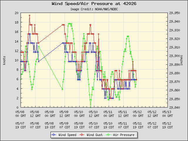
Pressure are definitely falling. currently dropping well past the daily mean afternoon pressure falls. wouldn't be surprised if we get a vort or two out of that convection west of Key west that tries to organize.
0 likes
Note: If I make a post that is brief. Please refer back to previous posts for the analysis or reasoning. I do not re-write/qoute what my initial post said each time.
If there is nothing before... then just ask
Space & Atmospheric Physicist, Embry-Riddle Aeronautical University,
I believe the sky is falling...
If there is nothing before... then just ask
Space & Atmospheric Physicist, Embry-Riddle Aeronautical University,
I believe the sky is falling...
-
gatorcane

- S2K Supporter
- Posts: 23499
- Age: 46
- Joined: Sun Mar 13, 2005 3:54 pm
- Location: Boca Raton, FL
Re: Disturbance in the SE Gulf of Mexico
Might be worth a mention by NHC. Regardless flooding concerns have increased across SE Florida and even the possibilities of tornado activity with the shear profile. All me mentioned in the latest NWS Miami discussion.
Vorticity is increasing:
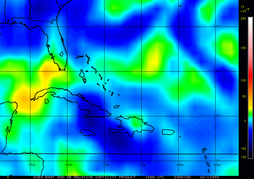
Vorticity is increasing:
1 likes
Re: Disturbance in the SE Gulf of Mexico
Has definitely been a soaker of a day down here in SFL but I don’t think that euro is gonna play out based on what we’ve had so far, that 14 inches is a bit south of where I live, but so far we’ve had maybe 2ish inches so far.
0 likes

Re: Disturbance in the SE Gulf of Mexico
tgenius wrote:Has definitely been a soaker of a day down here in SFL but I don’t think that euro is gonna play out based on what we’ve had so far, that 14 inches is a bit south of where I live, but so far we’ve had maybe 2ish inches so far.
Most of that rain is supposed to fall tomorrow not today, in fact we're under a marginal convective risk for tomorrow
0 likes
Kendall -> SLO -> PBC
Memorable Storms: Katrina (for its Florida landfall...) Wilma Matthew Irma
Memorable Storms: Katrina (for its Florida landfall...) Wilma Matthew Irma
Re: Disturbance in the SE Gulf of Mexico
Ubuntwo wrote:tgenius wrote:Has definitely been a soaker of a day down here in SFL but I don’t think that euro is gonna play out based on what we’ve had so far, that 14 inches is a bit south of where I live, but so far we’ve had maybe 2ish inches so far.
Most of that rain is supposed to fall tomorrow not today, in fact we're under a marginal convective risk for tomorrow
So your saying you think it will be what they are forecasting or will end up under (confused from the marginal convectice risk comment lol)
0 likes
Re: Disturbance in the SE Gulf of Mexico
tgenius wrote:Ubuntwo wrote:tgenius wrote:Has definitely been a soaker of a day down here in SFL but I don’t think that euro is gonna play out based on what we’ve had so far, that 14 inches is a bit south of where I live, but so far we’ve had maybe 2ish inches so far.
Most of that rain is supposed to fall tomorrow not today, in fact we're under a marginal convective risk for tomorrow
So your saying you think it will be what they are forecasting or will end up under (confused from the marginal convectice risk comment lol)
I’m saying south Florida is under a day 2 marginal convective risk in the SPC forecast. They mention heavy storms over the area as well as possible down bursts and tornadoes.
0 likes
Kendall -> SLO -> PBC
Memorable Storms: Katrina (for its Florida landfall...) Wilma Matthew Irma
Memorable Storms: Katrina (for its Florida landfall...) Wilma Matthew Irma

Re: Disturbance in the SE Gulf of Mexico
Crappy wx to be at the beach today in Sarasota, the wind has been picking up. I could had swear that three days ago I looked at the GFS and it was supposed to be a dry and hot day today.
There’s definitely a weak circulation to the west of Cuba.
There’s definitely a weak circulation to the west of Cuba.
0 likes
-
jlauderdal
- S2K Supporter
- Posts: 6771
- Joined: Wed May 19, 2004 5:46 am
- Location: NE Fort Lauderdale
- Contact:
Re: Disturbance in the SE Gulf of Mexico
1.6 since midnight at my house...I'm going with 4 by midnight based on pwat, modeling, current radar returnstgenius wrote:Has definitely been a soaker of a day down here in SFL but I don’t think that euro is gonna play out based on what we’ve had so far, that 14 inches is a bit south of where I live, but so far we’ve had maybe 2ish inches so far.
0 likes
Who is online
Users browsing this forum: AnnularCane, KirbyDude25, MetroMike, SFLcane and 97 guests