Which strong tropical storms do you think could have been classified as hurricanes?
My opinion (2003-present)
Nicholas 03
Peter 03
Delta 05
Alberto 06
Fay 08
Grace 09
Cindy 11
Beryl 12
Karl 16
Sebastian 19
Borderline Hurricanes
Moderator: S2k Moderators
Forum rules

The posts in this forum are NOT official forecasts and should not be used as such. They are just the opinion of the poster and may or may not be backed by sound meteorological data. They are NOT endorsed by any professional institution or STORM2K. For official information, please refer to products from the National Hurricane Center and National Weather Service.
-
BadLarry95
- Tropical Depression

- Posts: 94
- Joined: Thu Apr 28, 2016 9:40 pm
Borderline Hurricanes
1 likes
-
AtlanticWind

- S2K Supporter

- Posts: 1805
- Age: 65
- Joined: Sun Aug 08, 2004 9:57 pm
- Location: Plantation,Fla
-
Hurricanehink

- S2K Supporter
- Posts: 2022
- Joined: Sun Nov 16, 2003 2:05 pm
- Location: New Jersey

Re: Borderline Hurricanes
Fay definitely.
0 likes
Andrew (1992), Irene (1999), Frances (2004), Katrina (2005), Wilma (2005), Fay (2008), Irma (2017), Eta (2020), Ian (2022)
-
northjaxpro

- S2K Supporter
- Posts: 8900
- Joined: Mon Sep 27, 2010 11:21 am
- Location: Jacksonville, FL
Re: Borderline Hurricanes
Fay 2008.
Memorable storm for yours truly. Fay dumped nearly 15 inches of rainfall here at.my locale, with major flooding in Northeast Florida and caused major flooding down across Melbourne and East Central Florida.
Fay intensified crossing over the Everglades and developed an eye feature as it passed by Lake O. I will forever believe that Fay attained hurricane status briefly when it crossed over South Florida.
I still strongly believe Fay should have been among the tropical storm names retired at the very least. This has always bothered me through these past 12 years. Plus Fay made 4 different landfalls on the peninsula. It is still to this day the only recorded cyclone in history to do this!! Amazing storm!!
Last edited by northjaxpro on Wed Jun 24, 2020 5:44 pm, edited 3 times in total.
0 likes
NEVER, EVER SAY NEVER in the tropics and weather in general, and most importantly, with life itself!!
________________________________________________________________________________________
Fay 2008 Beryl 2012 Debby 2012 Colin 2016 Hermine 2016 Julia 2016 Matthew 2016 Irma 2017 Dorian 2019
________________________________________________________________________________________
Fay 2008 Beryl 2012 Debby 2012 Colin 2016 Hermine 2016 Julia 2016 Matthew 2016 Irma 2017 Dorian 2019

Re: Borderline Hurricanes
Hurricanehink wrote:Barry 01
Personally I think there was enough data (some chaser instrument measurements, radar estimates, radar presentation) with Barry that it should've been upgraded at least post-analysis.
1 likes
The above post is not official and should not be used as such. It is the opinion of the poster and may or may not be backed by sound meteorological data. It is not endorsed by any professional institution or storm2k.org. For official information, please refer to the NHC and NWS products.
-
northjaxpro
- S2K Supporter
- Posts: 8900
- Joined: Mon Sep 27, 2010 11:21 am
- Location: Jacksonville, FL
Re: Borderline Hurricanes
I want to touch on Beryl on Memorial Day weekend 2012. My.locale was directly impacted by the cyclone as the large CoC moved west across Jacksonville after making landfall at Jacksonville Beach. Beryl made the transition from subtropical to fully tropical after making the loop off the North Csrolina coast and then moved SW then due west by a very strong High Pressure Ridge that built in from the north.
Beryl did intensify on her approach to Jax Beach, and NHC had wind up to 70 mph just before landfall. I have often could make a case that Beryl also could have briefly became a hurricane as well. The center passed over my home station with sustained wind of 56 mph with a gust to 67 mph at its worst.
Beryl made history here in Jax that it was only the second tropical cyclone in the city's history to directly landfall from the east. Hurricane Dore in 1964 was the first. This is very tough here to happen more often due to the configuration (shape)of the coastline here in Northeast Florida. Beryl in 2012 remains the strongest early season cyclone, prior to June 1, to make landfall on the Continental U S.
Beryl moved through at a much quicker pace than Fay in 2008 which kept the flood threat to be much more reduced
My analysis: Both Fay in 2008 and Beryl in 2012 were historic storms. Fay in 2008, moreso in my opinion because of the extreme flooding. I covered and rode through both storms. They are among my most memorable weather events I have covered for sure through the years. I still use the satellite imagery of T.S. Beryl just prior to landfall here as my avatar in my profile.
2 likes
NEVER, EVER SAY NEVER in the tropics and weather in general, and most importantly, with life itself!!
________________________________________________________________________________________
Fay 2008 Beryl 2012 Debby 2012 Colin 2016 Hermine 2016 Julia 2016 Matthew 2016 Irma 2017 Dorian 2019
________________________________________________________________________________________
Fay 2008 Beryl 2012 Debby 2012 Colin 2016 Hermine 2016 Julia 2016 Matthew 2016 Irma 2017 Dorian 2019
-
toad strangler

- S2K Supporter
- Posts: 4162
- Joined: Sun Jul 28, 2013 3:09 pm
- Location: Earth
- Contact:
Re: Borderline Hurricanes
northjaxpro wrote:I want to touch on Beryl on Memorial Day weekend 2012. My.locale was directly impacted by the cyclone as the large CoC moved west across Jacksonville after making landfall at Jacksonville Beach. Beryl made the transition from subtropical to fully tropical after making the loop off the North Csrolina coast and then moved SW then due west by a very strong High Pressure Ridge that built in from the north.
Beryl did intensify on her approach to Jax Beach, and NHC had wind up to 70 mph just before landfall. I have often could make a case that Beryl also could have briefly became a hurricane as well. The center passed over my home station with sustained wind of 56 mph with a gust to 67 mph at its worst.
Beryl made history here in Jax that it was only the second tropical cyclone in the city's history to directly landfall from the east. Hurricane Dore in 1964 was the first. This is very tough here to happen more often due to the configuration (shape)of the coastline here in Northeast Florida. Beryl in 2012 remains the strongest early season cyclone, prior to June 1, to make landfall on the Continental U S.
Beryl moved through at a much quicker pace than Fay in 2008 which kept the flood threat to be much more reduced
My analysis: Both Fay in 2008 and Beryl in 2012 were historic storms. Fay in 2008, moreso in my opinion because of the extreme flooding. I covered and rode through both storms. They are among my most memorable weather events I have covered for sure through the years. I still use the satellite imagery of T.S. Beryl just prior to landfall here as my avatar in my profile.
Fay happened the year before I moved to FL but everyone I talk to remembers it as if it was Andrew. The very slow movement and meandering track that had nearly the entire peninsula be inundated with flooding rains. Everybody looks at major hurricane hits or even Cat 1 and 2 hits but its TS like this that can cause WORSE havoc than a major can given the aforementioned factors. More recently TS Imelda caused even worse flooding issues in TX. The winds get all the attention in majors but water does the dirtiest work "under the radar" and are forgotten over time by the majority looking for the wind makers.
0 likes
-
TheAustinMan

- Category 4

- Posts: 997
- Age: 24
- Joined: Mon Jul 08, 2013 4:26 pm
- Location: United States
- Contact:
Re: Borderline Hurricanes
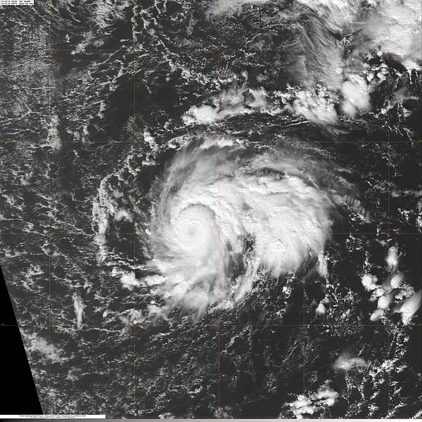
Speaking of Beryls, how about the small and compact Beryl 1982. It's listed in the books as a high-end 70 mph tropical storm at peak, but it was officially a 35 mph tropical depression when the satellite images below were taken. I think the well-defined central dense overcast and faint eye speak for themselves. If the same intensity was assigned with today's data quality and coverage, there would probably be a lot of head scratching. I think Beryl 1982 deserves to be in the exclusive company of tropical cyclones that reached hurricane strength in this region, with Fred 2015 being the most recent case.
1.1 and 1.3 MB. Source: Image data from NOAA CLASS and processed myself.


60 KB. Source: The HURSAT image directory

1.1 and 1.3 MB. Source: Image data from NOAA CLASS and processed myself.
60 KB. Source: The HURSAT image directory
8 likes


Treat my opinions with a grain of salt. For official information see your local weather service.
-
CrazyC83
- Professional-Met

- Posts: 33393
- Joined: Tue Mar 07, 2006 11:57 pm
- Location: Deep South, for the first time!
Re: Borderline Hurricanes
TheAustinMan wrote:Speaking of Beryls, how about the small and compact Beryl 1982. It's listed in the books as a high-end 70 mph tropical storm at peak, but it was officially a 35 mph tropical depression when the satellite images below were taken. I think the well-defined central dense overcast and faint eye speak for themselves. If the same intensity was assigned with today's data quality and coverage, there would probably be a lot of head scratching. I think Beryl 1982 deserves to be in the exclusive company of tropical cyclones that reached hurricane strength in this region, with Fred 2015 being the most recent case.
1.1 and 1.3 MB. Source: Image data from NOAA CLASS and processed myself.
https://i.imgur.com/M5pvRRO.png
https://i.imgur.com/L2eQkcg.png
60 KB. Source: The HURSAT image directory
https://i.imgur.com/vHpF0kH.png
Looking at those images, with the eye and deep cloud tops, that looks like T4.5 to T5.0 for me. I'd say 85 kt for the intensity there (pressure 981 mb).
6 likes
Re: Borderline Hurricanes
When is the reanalysis project going to do 80s storms? Beryl '82 should definitely be up to hurricane strength 
0 likes
Andrew (1992), Irene (1999), Frances (2004), Katrina (2005), Wilma (2005), Fay (2008), Irma (2017), Eta (2020), Ian (2022)
Re: Borderline Hurricanes
MoliNuno wrote:When is the reanalysis project going to do 80s storms? Beryl '82 should definitely be up to hurricane strength
Judging by the rate they've gone at so far and the increasing amount of data to work with I'd guess it could take about 5-10 more years since 1966-70 seems like it'll be the next batch and the preliminary was a year or two ago.
0 likes
The above post is not official and should not be used as such. It is the opinion of the poster and may or may not be backed by sound meteorological data. It is not endorsed by any professional institution or storm2k.org. For official information, please refer to the NHC and NWS products.
-
doomhaMwx

- Category 5

- Posts: 2398
- Age: 25
- Joined: Tue Apr 18, 2017 4:01 am
- Location: Baguio/Benguet, Philippines
- Contact:
Re: Borderline Hurricanes
How about (Sub)tropical storm Omeka near the Int'l Dateline in Dec 2010? Omeka probably reached typhoon intensity in the WPAC (at the time of the images below) before moving over the CPAC, but JMA/JTWC basically ignored it. SAB even gave it a dvorak rating of T4.5 at one point.
Topic/page about Omeka: viewtopic.php?f=72&t=110121


Topic/page about Omeka: viewtopic.php?f=72&t=110121
5 likes
Like my content? Consider giving a tip.
Who is online
Users browsing this forum: chaser1, Old-TimeCane and 211 guests