

Tropical Wave Over the Bahamas/Cuba (Is Invest 91L)
Moderator: S2k Moderators
Forum rules

The posts in this forum are NOT official forecasts and should not be used as such. They are just the opinion of the poster and may or may not be backed by sound meteorological data. They are NOT endorsed by any professional institution or STORM2K. For official information, please refer to products from the National Hurricane Center and National Weather Service.
Tropical Wave Over the Bahamas/Cuba (Is Invest 91L)
We'll be watching this tropical wave as it tracks westward towards the Bahamas, S FL and into the GOM over the next days. This the TW that the latest GFS develops into a weak TS in the GOM.
Last edited by NDG on Sat Jul 18, 2020 8:35 am, edited 1 time in total.
1 likes
Re: Tropical Wave east of the Lesser Antilles
GEFS support increasing during the past few runs.

2 likes
Re: Tropical Wave east of the Lesser Antilles
The Euro does not develop maybe because it keeps the mid & ULL ahead of it too close to the surface trough/vorticity, but it shows the TW nicely on its simulated vis sat forecast, blossoming as it nears western Bahamas/FL into the GOM Sunday into early next week.

1 likes
-
Aric Dunn
- Category 5

- Posts: 21228
- Age: 41
- Joined: Sun Sep 19, 2004 9:58 pm
- Location: Ready for the Chase.
- Contact:
Re: Tropical Wave east of the Lesser Antilles
Hey look someone started a thread.. lol
If it stays just a little farther north and does not ride the coast of the Greater Antilles then I would imagine the Euro would probably start jumping on board.
ICON was developing it.. but now has the vorticity also interacting with the islands..
have to watch closely..since all models show convection increasing as it approaches the SE bahamas.
0 likes
Note: If I make a post that is brief. Please refer back to previous posts for the analysis or reasoning. I do not re-write/qoute what my initial post said each time.
If there is nothing before... then just ask
Space & Atmospheric Physicist, Embry-Riddle Aeronautical University,
I believe the sky is falling...
If there is nothing before... then just ask
Space & Atmospheric Physicist, Embry-Riddle Aeronautical University,
I believe the sky is falling...
-
Aric Dunn
- Category 5
- Posts: 21228
- Age: 41
- Joined: Sun Sep 19, 2004 9:58 pm
- Location: Ready for the Chase.
- Contact:
Re: Tropical Wave east of the Lesser Antilles
00z CMC nearly develops it as it crosses florida and heads to New Orleans.
0 likes
Note: If I make a post that is brief. Please refer back to previous posts for the analysis or reasoning. I do not re-write/qoute what my initial post said each time.
If there is nothing before... then just ask
Space & Atmospheric Physicist, Embry-Riddle Aeronautical University,
I believe the sky is falling...
If there is nothing before... then just ask
Space & Atmospheric Physicist, Embry-Riddle Aeronautical University,
I believe the sky is falling...
-
TheStormExpert

- Category 5
- Posts: 8487
- Age: 30
- Joined: Wed Feb 16, 2011 5:38 pm
- Location: Palm Beach Gardens, FL
Re: Tropical Wave east of the Lesser Antilles
Should get a mention by the NHC next week once it gets near Florida assuming model support doesn’t completely drop.
0 likes
The following post is NOT an official forecast and should not be used as such. It is just the opinion of the poster and may or may not be backed by sound meteorological data. It is NOT endorsed by storm2k.org.
-
AJC3

- Admin

- Posts: 3869
- Age: 60
- Joined: Tue Aug 31, 2004 7:04 pm
- Location: West Melbourne, Florida
- Contact:
Re: Tropical Wave Near the Lesser Antilles (61/62W)
Tropical Weather Discussion
NWS National Hurricane Center Miami FL
735 PM EDT Fri Jul 17 2020
...TROPICAL WAVES...
The axis of a tropical wave is analyzed along 61W/62W, from 20N
southward, moving westward at 10 to 15 knots. Widely scattered
showers are moving across the Lesser Antilles and the adjacent
Atlantic waters north through northeast, otherwise no significant
convection is associated with this wave.
(thread has been cleaned up to remove references/dicussion of a trailng t-wave)
2 likes
Re: Tropical Wave Near the Lesser Antilles (61/62W)
This TW has lost just about all support for development in the GOM in the past 24 hrs, just a couple of GFS and Euro members show weak development before approaching the TX coast next week.
0 likes
-
Aric Dunn
- Category 5
- Posts: 21228
- Age: 41
- Joined: Sun Sep 19, 2004 9:58 pm
- Location: Ready for the Chase.
- Contact:
Re: Tropical Wave Near the Lesser Antilles (63/64W)
Well I would not count it out just yet.
if you notice the models run this wave down the middle of Hispaniola and now the entire length of Cuba.. not surprised the models lose it.
However, the wave axis is clearly not that far south. looks like it will go north of Hispaniola which would bring us back to the GFS runs.

if you notice the models run this wave down the middle of Hispaniola and now the entire length of Cuba.. not surprised the models lose it.
However, the wave axis is clearly not that far south. looks like it will go north of Hispaniola which would bring us back to the GFS runs.
6 likes
Note: If I make a post that is brief. Please refer back to previous posts for the analysis or reasoning. I do not re-write/qoute what my initial post said each time.
If there is nothing before... then just ask
Space & Atmospheric Physicist, Embry-Riddle Aeronautical University,
I believe the sky is falling...
If there is nothing before... then just ask
Space & Atmospheric Physicist, Embry-Riddle Aeronautical University,
I believe the sky is falling...
-
Aric Dunn
- Category 5
- Posts: 21228
- Age: 41
- Joined: Sun Sep 19, 2004 9:58 pm
- Location: Ready for the Chase.
- Contact:
Re: Tropical Wave Near the Lesser Antilles (63/64W)
Models definitely have the wave axis placed wrong by quite a bit..
along with cloud tracking the wave axis TPW also shows it well north of where the GFS has it.


6z GFS has it well south mostly in the Carrib.
So assuming in later model runs the wave axis and vorticity are initialized correctly. we will probably see a return to development.

along with cloud tracking the wave axis TPW also shows it well north of where the GFS has it.
6z GFS has it well south mostly in the Carrib.
So assuming in later model runs the wave axis and vorticity are initialized correctly. we will probably see a return to development.
1 likes
Note: If I make a post that is brief. Please refer back to previous posts for the analysis or reasoning. I do not re-write/qoute what my initial post said each time.
If there is nothing before... then just ask
Space & Atmospheric Physicist, Embry-Riddle Aeronautical University,
I believe the sky is falling...
If there is nothing before... then just ask
Space & Atmospheric Physicist, Embry-Riddle Aeronautical University,
I believe the sky is falling...
-
Aric Dunn
- Category 5
- Posts: 21228
- Age: 41
- Joined: Sun Sep 19, 2004 9:58 pm
- Location: Ready for the Chase.
- Contact:
Re: Tropical Wave Near the Lesser Antilles (63/64W)
GFS for the 12z RUN again has the wave/vorticity mostly over PR and in the Carrib which is not the case. which is odd.
The 12z ICON is back to having a stronger 850 mb vort again though.
The 12z ICON is back to having a stronger 850 mb vort again though.
1 likes
Note: If I make a post that is brief. Please refer back to previous posts for the analysis or reasoning. I do not re-write/qoute what my initial post said each time.
If there is nothing before... then just ask
Space & Atmospheric Physicist, Embry-Riddle Aeronautical University,
I believe the sky is falling...
If there is nothing before... then just ask
Space & Atmospheric Physicist, Embry-Riddle Aeronautical University,
I believe the sky is falling...
-
Aric Dunn
- Category 5
- Posts: 21228
- Age: 41
- Joined: Sun Sep 19, 2004 9:58 pm
- Location: Ready for the Chase.
- Contact:
Re: Tropical Wave Near the Lesser Antilles (63/64W)
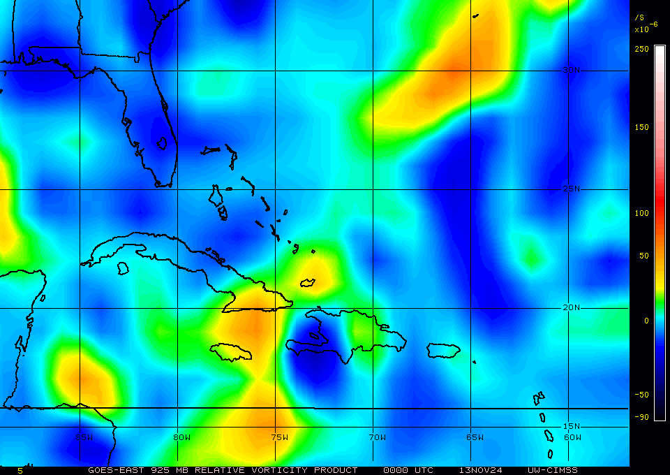
925mb Vorticity is showing it in the correct area but the models dont seem to have a handle on much of anything east of the US lately.
0 likes
Note: If I make a post that is brief. Please refer back to previous posts for the analysis or reasoning. I do not re-write/qoute what my initial post said each time.
If there is nothing before... then just ask
Space & Atmospheric Physicist, Embry-Riddle Aeronautical University,
I believe the sky is falling...
If there is nothing before... then just ask
Space & Atmospheric Physicist, Embry-Riddle Aeronautical University,
I believe the sky is falling...
-
Aric Dunn
- Category 5
- Posts: 21228
- Age: 41
- Joined: Sun Sep 19, 2004 9:58 pm
- Location: Ready for the Chase.
- Contact:
Re: Tropical Wave Near the Lesser Antilles (63/64W)
After running the vorticity through the middle of Hispaniola and Cuba slightly farther south than the last run..
GFS squeaks in a possible TD before texas.

GFS squeaks in a possible TD before texas.
1 likes
Note: If I make a post that is brief. Please refer back to previous posts for the analysis or reasoning. I do not re-write/qoute what my initial post said each time.
If there is nothing before... then just ask
Space & Atmospheric Physicist, Embry-Riddle Aeronautical University,
I believe the sky is falling...
If there is nothing before... then just ask
Space & Atmospheric Physicist, Embry-Riddle Aeronautical University,
I believe the sky is falling...
Re: Tropical Wave Near the Lesser Antilles (63/64W)
Aric Dunn wrote:Models definitely have the wave axis placed wrong by quite a bit..
along with cloud tracking the wave axis TPW also shows it well north of where the GFS has it.
https://i.ibb.co/gWhGd6m/Capture2.png
https://i.ibb.co/yBc4qN8/LABELS-19700101-000000.gif
Yes, definitely the vorticity is further north than where the models have it.
6z GFS has it well south mostly in the Carrib.
So assuming in later model runs the wave axis and vorticity are initialized correctly. we will probably see a return to development.
https://i.ibb.co/VQ7dCcp/Capture.png
0 likes
-
Aric Dunn
- Category 5
- Posts: 21228
- Age: 41
- Joined: Sun Sep 19, 2004 9:58 pm
- Location: Ready for the Chase.
- Contact:
Re: Tropical Wave Near the Lesser Antilles (63/64W)
12z Euro finally has it in the right location. lets see what happens..

0 likes
Note: If I make a post that is brief. Please refer back to previous posts for the analysis or reasoning. I do not re-write/qoute what my initial post said each time.
If there is nothing before... then just ask
Space & Atmospheric Physicist, Embry-Riddle Aeronautical University,
I believe the sky is falling...
If there is nothing before... then just ask
Space & Atmospheric Physicist, Embry-Riddle Aeronautical University,
I believe the sky is falling...
-
toad strangler

- S2K Supporter

- Posts: 4162
- Joined: Sun Jul 28, 2013 3:09 pm
- Location: Earth
- Contact:
-
AJC3
- Admin
- Posts: 3869
- Age: 60
- Joined: Tue Aug 31, 2004 7:04 pm
- Location: West Melbourne, Florida
- Contact:
Re: Tropical Wave Near Hispaniola
TWOAT
Tropical Weather Outlook
NWS National Hurricane Center Miami FL
200 AM EDT Sun Jul 19 2020
For the North Atlantic...Caribbean Sea and the Gulf of Mexico:
A tropical wave located over eastern Hispaniola and the adjacent
waters of the southwestern Atlantic is expected to move
west-northwestward over the next several days and enter the
southeastern Gulf of Mexico by late Tuesday, and then move across
the central Gulf on Wednesday and reach the northwestern Gulf on
Thursday. This disturbance is currently producing only minimal
shower activity, but environmental conditions are expected to become
at least marginally conducive for development by Wednesday or
Thursday.
* Formation chance through 48 hours...low...near 0 percent.
* Formation chance through 5 days...low...20 percent.
1 likes

-
cycloneye

- Admin
- Posts: 139028
- Age: 67
- Joined: Thu Oct 10, 2002 10:54 am
- Location: San Juan, Puerto Rico
Re: Tropical Wave Near Hispaniola
Tropical Weather Outlook
NWS National Hurricane Center Miami FL
800 AM EDT Sun Jul 19 2020
For the North Atlantic...Caribbean Sea and the Gulf of Mexico:
A tropical wave located over Hispaniola and the adjacent waters of
the southwestern Atlantic is expected to move west-northwestward
over the next several days and enter the southeastern Gulf of
Mexico by late Tuesday, and then move across the central Gulf on
Wednesday and reach the northwestern Gulf on Thursday. This
disturbance is currently producing disorganized shower activity,
but environmental conditions are expected to become at least
marginally conducive for development by Wednesday or Thursday.
* Formation chance through 48 hours...low...near 0 percent.
* Formation chance through 5 days...low...20 percent.
$$
Forecaster Beven
0 likes
Visit the Caribbean-Central America Weather Thread where you can find at first post web cams,radars
and observations from Caribbean basin members Click Here
and observations from Caribbean basin members Click Here
Who is online
Users browsing this forum: Christiana, Google Adsense [Bot], Hurricane2022, JetFuel_SE and 119 guests