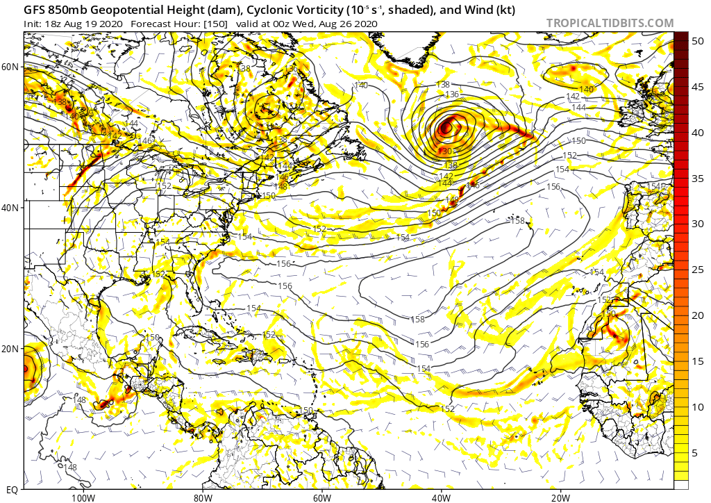
No, I think there will be plenty systems, but I was just commenting on theCpv17 wrote:otowntiger wrote:Yeah that set up could be problematic, but of note is that there are no systems shown to worry about. So the set up isn't really problematic if there are no storms to be steered by it. Of course I know its all subject to change and there could be some waves to watch, but by the same token the set up could be different as well with the usual troughs and retreating ridge allowing for the proverbial 'escape hatch'.gatorcane wrote:Here is what the 18Z Aug 19th GFS run showed for today’s forecast (7 days out):
https://i.postimg.cc/fbzS3Qjx/gfs-z850-vort-atl-26.png
But do you really think there will be no systems to watch going into the heart of the season? Doubtful. Have you seen the CMC, UKMET, and ICON who have blown away the GFS/Euro at detecting genesis this year?
Central Atlantic Tropical Wave (Is Invest 91L)
Moderator: S2k Moderators
Forum rules

The posts in this forum are NOT official forecasts and should not be used as such. They are just the opinion of the poster and may or may not be backed by sound meteorological data. They are NOT endorsed by any professional institution or STORM2K. For official information, please refer to products from the National Hurricane Center and National Weather Service.
-
otowntiger
- Category 5

- Posts: 1787
- Joined: Tue Aug 31, 2004 7:06 pm
- Location: Orlando
Re: Strong Wave to Emerge from Africa today: latest EPS active near CONUS/Bahamas
0 likes
-
otowntiger
- Category 5
- Posts: 1787
- Joined: Tue Aug 31, 2004 7:06 pm
- Location: Orlando
Re: Strong Wave to Emerge from Africa today: latest EPS active near CONUS/Bahamas
AxaltaRacing24 wrote:otowntiger wrote:Yeah that set up could be problematic, but of note is that there are no systems shown to worry about. So the set up isn't really problematic if there are no storms to be steered by it. Of course I know its all subject to change and there could be some waves to watch, but by the same token the set up could be different as well with the usual troughs and retreating ridge allowing for the proverbial 'escape hatch'.gatorcane wrote:Here is what the 18Z Aug 19th GFS run showed for today’s forecast (7 days out):
https://i.postimg.cc/fbzS3Qjx/gfs-z850-vort-atl-26.png
you missed the point of the post. that picture he posted was the august 19th gfs forecast for the day laura made landfall. notice how there's not a hint of a storm just 7 days out.
this is why you do not take models for gospel when it comes to TC genesis.
ahh, yep. I did miss that point entirely. I thought the
2 likes
-
toad strangler

- S2K Supporter

- Posts: 4162
- Joined: Sun Jul 28, 2013 3:09 pm
- Location: Earth
- Contact:
Re: Strong Wave to Emerge from Africa today: latest EPS active near CONUS/Bahamas
otowntiger wrote:No, I think there will be plenty systems, but I was just commenting on theCpv17 wrote:otowntiger wrote: Yeah that set up could be problematic, but of note is that there are no systems shown to worry about. So the set up isn't really problematic if there are no storms to be steered by it. Of course I know its all subject to change and there could be some waves to watch, but by the same token the set up could be different as well with the usual troughs and retreating ridge allowing for the proverbial 'escape hatch'.
But do you really think there will be no systems to watch going into the heart of the season? Doubtful. Have you seen the CMC, UKMET, and ICON who have blown away the GFS/Euro at detecting genesis this year?
Not a lot of support from what? Models I'd assume you mean, which looking for model support for genesis is a dicey proposition in 2020.
2 likes
-
eastcoastFL

- Category 5
- Posts: 3437
- Age: 42
- Joined: Thu Apr 12, 2007 12:29 pm
- Location: Palm City, FL
Re: Strong Wave off African Coast
Is this a different wave?


Last edited by eastcoastFL on Thu Aug 27, 2020 3:24 pm, edited 1 time in total.
0 likes
Personal Forecast Disclaimer:
The posts in this forum are NOT official forecast and should not be used as such. They are just the opinion of the poster and may or may not be backed by sound meteorological data. They are NOT endorsed by any professional institution or storm2k.org. For official information, please refer to the NHC and NWS products.
The posts in this forum are NOT official forecast and should not be used as such. They are just the opinion of the poster and may or may not be backed by sound meteorological data. They are NOT endorsed by any professional institution or storm2k.org. For official information, please refer to the NHC and NWS products.
-
Extratropical94

- Professional-Met

- Posts: 3535
- Age: 29
- Joined: Wed Oct 20, 2010 6:36 am
- Location: Hamburg, Germany
- Contact:
Re: Tropical Wave off the African Coast
In the 12Z Euro, the wave doesn't develop, but it catches up to the one in front of it (the 41W) and overtakes it, moving off towards Florida. The 41W wave develops into a weak TC and moves into Honduras. In fact, the 12Z Euro only really develops the wave after this one (i.e. the one that is still over Africa). Too many waves out there 
6 likes
54° 11' 59'' N, 9° 9' 20'' E
Boomer Sooner!
Go Broncos! Go Cards! Go Niners!
- Daniel
Boomer Sooner!
Go Broncos! Go Cards! Go Niners!
- Daniel
-
cycloneye

- Admin

- Posts: 139068
- Age: 67
- Joined: Thu Oct 10, 2002 10:54 am
- Location: San Juan, Puerto Rico
Re: Tropical Wave off the African Coast
A tropical wave located over the eastern Atlantic Ocean just west
of the Cabo Verde Islands is producing disorganized shower and
thunderstorm activity. The northern part of this wave, which is
expected to move rapidly westward over the central Atlantic during
the next few days, is forecast to remain too far to the north and
in an unfavorable environment for development to occur. However,
the southern part of the wave is expected be nearly stationary
south of the Cabo Verde Islands for the next several days, and some
development of this system is possible early next week when it
begins to move slowly westward over the eastern and central
tropical Atlantic.
* Formation chance through 48 hours...low...near 0 percent.
* Formation chance through 5 days...low...30 percent.

1 likes
Visit the Caribbean-Central America Weather Thread where you can find at first post web cams,radars
and observations from Caribbean basin members Click Here
and observations from Caribbean basin members Click Here
-
AnnularCane

- S2K Supporter
- Posts: 2634
- Joined: Thu Jun 08, 2006 9:18 am
- Location: Wytheville, VA
Re: Tropical Wave off the African Coast
Looks like the line between the X and the oval got a lot shorter.
ETA: Oh, I think I see why. How common is it for African waves to just sit there?
ETA: Oh, I think I see why.
0 likes
-
DorkyMcDorkface

- Category 2

- Posts: 697
- Age: 26
- Joined: Mon Sep 30, 2019 1:32 pm
- Location: Mid-Atlantic
Re: Tropical Wave off the African Coast
So from what I understand from both the NHC and the models the northern part of the wave will race off to the west and the southern part of the wave will get caught within the weak trade wind flow in the MDR and merge with another wave coming off Africa? Man, the MDR has been like a Rube-Goldberg contraption when it comes to cyclogenesis this year.
9 likes
Floyd 1999 | Isabel 2003 | Hanna 2008 | Irene 2011 | Sandy 2012 | Isaias 2020
-
SFLcane

- S2K Supporter
- Posts: 9606
- Age: 46
- Joined: Sat Jun 05, 2010 1:44 pm
- Location: Lake Worth Florida
Re: Tropical Wave off the African Coast
This wave is one to watch closely now with a location further south. Could develop in SW Atlantic long range.
2 likes
Re: Tropical Wave off the African Coast
AnnularCane wrote:Looks like the line between the X and the oval got a lot shorter.
ETA: Oh, I think I see why.
Extremely unusual in late August
1 likes
-
AutoPenalti
- Category 5
- Posts: 3949
- Age: 27
- Joined: Mon Aug 17, 2015 4:16 pm
- Location: Ft. Lauderdale, Florida
Re: Tropical Wave off the African Coast
Wait, I’m confused.
Which wave is being developed by the GFS?
Which wave is being developed by the GFS?
1 likes
The posts in this forum are NOT official forecasts and should not be used as such. They are just the opinion of the poster and may or may not be backed by sound meteorological data. They are NOT endorsed by any professional institution or STORM2K. For official information, please refer to products from the NHC and NWS.
Model Runs Cheat Sheet:
GFS (5:30 AM/PM, 11:30 AM/PM)
HWRF, GFDL, UKMET, NAVGEM (6:30-8:00 AM/PM, 12:30-2:00 AM/PM)
ECMWF (1:45 AM/PM)
TCVN is a weighted averaged
-
TheStormExpert

- Category 5
- Posts: 8487
- Age: 30
- Joined: Wed Feb 16, 2011 5:38 pm
- Location: Palm Beach Gardens, FL
Re: Tropical Wave off the African Coast
SFLcane wrote:This wave is one to watch closely now with a location further south. Could develop in SW Atlantic long range.
Right now it looks like there will be a break in the ridge which could allow this to go out to sea depending on how quickly this develops. Of course significant development doesn’t occur until a week away so changes are more than likely.
0 likes
The following post is NOT an official forecast and should not be used as such. It is just the opinion of the poster and may or may not be backed by sound meteorological data. It is NOT endorsed by storm2k.org.
-
TheStormExpert
- Category 5
- Posts: 8487
- Age: 30
- Joined: Wed Feb 16, 2011 5:38 pm
- Location: Palm Beach Gardens, FL
Re: Tropical Wave off the African Coast
AutoPenalti wrote:Wait, I’m confused.
Which wave is being developed by the GFS?
This wave splits into two and the southern lobe quickly develops in a week and the northern lobe briefly develops into something very weak just NE of the southern lobe. This could be partially why the southern lobe goes out to sea on the 18z GFS.
0 likes
The following post is NOT an official forecast and should not be used as such. It is just the opinion of the poster and may or may not be backed by sound meteorological data. It is NOT endorsed by storm2k.org.
-
SFLcane
- S2K Supporter
- Posts: 9606
- Age: 46
- Joined: Sat Jun 05, 2010 1:44 pm
- Location: Lake Worth Florida
Re: Tropical Wave off the African Coast
This AEW seems to have fizzled. Models have been very inconsistent in general the gfs was showing development of this wave for a few runs dropped it overnight.
Edit: it’s back on the 06z with a huge trof waiting to recurve it thankfully!

Edit: it’s back on the 06z with a huge trof waiting to recurve it thankfully!
Last edited by SFLcane on Fri Aug 28, 2020 6:22 am, edited 3 times in total.
0 likes
-
hurricaneCW
- Category 5
- Posts: 1773
- Joined: Wed Mar 03, 2010 6:20 am
- Location: Toms River, NJ
Re: Tropical Wave off the African Coast
SFLcane wrote:This AEW seems to have fizzled. Models have been very inconsistent in general the gfs was showing development of this wave for a few runs dropped it overnight.
Edit: it’s back on the 06z with a huge trof waiting to recurve it thankfully.
https://i.imgur.com/7lDsv5c.gif
I'd be willing to bet the house that the deep trough is BS. Despite that the GFS still gets it past 70W.
1 likes
-
SFLcane
- S2K Supporter
- Posts: 9606
- Age: 46
- Joined: Sat Jun 05, 2010 1:44 pm
- Location: Lake Worth Florida
Re: Tropical Wave off the African Coast
hurricaneCW wrote:SFLcane wrote:This AEW seems to have fizzled. Models have been very inconsistent in general the gfs was showing development of this wave for a few runs dropped it overnight.
Edit: it’s back on the 06z with a huge trof waiting to recurve it thankfully.
https://i.imgur.com/7lDsv5c.gif
I'd be willing to bet the house that the deep trough is BS. Despite that the GFS still gets it past 70W.
Fall coming apparently.
60’s all the way to Tallahassee
0 likes
-
TheStormExpert
- Category 5
- Posts: 8487
- Age: 30
- Joined: Wed Feb 16, 2011 5:38 pm
- Location: Palm Beach Gardens, FL
Re: Tropical Wave off the African Coast
hurricaneCW wrote:SFLcane wrote:This AEW seems to have fizzled. Models have been very inconsistent in general the gfs was showing development of this wave for a few runs dropped it overnight.
Edit: it’s back on the 06z with a huge trof waiting to recurve it thankfully.
https://i.imgur.com/7lDsv5c.gif
I'd be willing to bet the house that the deep trough is BS. Despite that the GFS still gets it past 70W.
Same! Too bad it’s beyond the 10 day range which is VERY unreliable. I much rather be the target in this range than seeing a recurving hurricane which poses only a threat to the NE Caribbean, Bermuda, or the NE U.S. and Canada.
0 likes
The following post is NOT an official forecast and should not be used as such. It is just the opinion of the poster and may or may not be backed by sound meteorological data. It is NOT endorsed by storm2k.org.
-
TheStormExpert
- Category 5
- Posts: 8487
- Age: 30
- Joined: Wed Feb 16, 2011 5:38 pm
- Location: Palm Beach Gardens, FL
Re: Tropical Wave off the African Coast
SFLcane wrote:hurricaneCW wrote:SFLcane wrote:This AEW seems to have fizzled. Models have been very inconsistent in general the gfs was showing development of this wave for a few runs dropped it overnight.
Edit: it’s back on the 06z with a huge trof waiting to recurve it thankfully.
https://i.imgur.com/7lDsv5c.gif
I'd be willing to bet the house that the deep trough is BS. Despite that the GFS still gets it past 70W.
Fall coming apparently.
60’s all the way to Tallahassee
What 60’s? Not disagreeing with you SFLcane but the overall steering pattern forecasted for September for the past month or so reeked of ridging.

0 likes
The following post is NOT an official forecast and should not be used as such. It is just the opinion of the poster and may or may not be backed by sound meteorological data. It is NOT endorsed by storm2k.org.
-
SFLcane
- S2K Supporter
- Posts: 9606
- Age: 46
- Joined: Sat Jun 05, 2010 1:44 pm
- Location: Lake Worth Florida
Re: Tropical Wave off the African Coast
TheStormExpert wrote:SFLcane wrote:hurricaneCW wrote:
I'd be willing to bet the house that the deep trough is BS. Despite that the GFS still gets it past 70W.
Fall coming apparently.
60’s all the way to Tallahassee
What 60’s? Not disagreeing with you SFLcane but the overall steering pattern forecasted for September for the past month or so reeked of ridging.
https://i.ibb.co/fds8dYK/AA02538-E-9970-4927-B3-A4-70-ED730-CB55-C.png


1 likes
-
TheStormExpert
- Category 5
- Posts: 8487
- Age: 30
- Joined: Wed Feb 16, 2011 5:38 pm
- Location: Palm Beach Gardens, FL
Re: Tropical Wave off the African Coast
SFLcane wrote:TheStormExpert wrote:SFLcane wrote:
Fall coming apparently.
60’s all the way to Tallahassee
What 60’s? Not disagreeing with you SFLcane but the overall steering pattern forecasted for September for the past month or so reeked of ridging.
https://i.ibb.co/fds8dYK/AA02538-E-9970-4927-B3-A4-70-ED730-CB55-C.png

https://i.imgur.com/YLCMofV.gif
Maybe this is right as the NAO is forecasted to stay ever so slightly negative. But it’s 300+ hours out.
0 likes
The following post is NOT an official forecast and should not be used as such. It is just the opinion of the poster and may or may not be backed by sound meteorological data. It is NOT endorsed by storm2k.org.
Who is online
Users browsing this forum: kevin and 192 guests