Trough of low pressure in Western Caribbean (Is Invest 95L)
Moderator: S2k Moderators
Forum rules

The posts in this forum are NOT official forecasts and should not be used as such. They are just the opinion of the poster and may or may not be backed by sound meteorological data. They are NOT endorsed by any professional institution or STORM2K. For official information, please refer to products from the National Hurricane Center and National Weather Service.
Re: Trough of low pressure in Western Caribbean
I'm definitely tuned in. there's a reason the NHC reevaluates things every 6 hours.
0 likes
Re: Trough of low pressure in Western Caribbean
Spacecoast wrote:https://i.ibb.co/DfCTM1W/Capture1017a.jpg
No 18Z NAVGEM TC genesis technically, but as I posted it does have a surface low at hour 138 just off S FL right where the 12Z UKMET 144 has its TD.
0 likes
Personal Forecast Disclaimer:
The posts in this forum are NOT official forecasts and should not be used as such. They are just the opinion of the poster and may or may not be backed by sound meteorological data. They are NOT endorsed by any professional institution or storm2k.org. For official information, please refer to the NHC and NWS products.
The posts in this forum are NOT official forecasts and should not be used as such. They are just the opinion of the poster and may or may not be backed by sound meteorological data. They are NOT endorsed by any professional institution or storm2k.org. For official information, please refer to the NHC and NWS products.
-
Spacecoast

- Category 2

- Posts: 687
- Joined: Thu Aug 31, 2017 2:03 pm
Re: Trough of low pressure in Western Caribbean
I've highlighted on the 18z GEFS what I think the NHC currently has @ 10% development.
The GEFS @18 hrs seems to split it's members between the north lobe, and south lobe.
NHC seems to be going with the northern group , expecting this large disturbance to consolidate to the north, and move westward over Yucatan wednesday

An alternate solution is depicted by the southern GEFS members, with the disturbance consolidating to the south, and eventually heading north toward Cuba. The UKMET may be going with this southern solution.
Approx. twelve southern members are shown @ hour 132 in bright orange (higher spread, lower confidence) represent ~37% of the original 32 members.
It's a possible solution, but the other 63% seem to go toward yucatan tightly clustered, with a norm spread of <1 (higher confidence), or never develop.

The GEFS @18 hrs seems to split it's members between the north lobe, and south lobe.
NHC seems to be going with the northern group , expecting this large disturbance to consolidate to the north, and move westward over Yucatan wednesday
An alternate solution is depicted by the southern GEFS members, with the disturbance consolidating to the south, and eventually heading north toward Cuba. The UKMET may be going with this southern solution.
Approx. twelve southern members are shown @ hour 132 in bright orange (higher spread, lower confidence) represent ~37% of the original 32 members.
It's a possible solution, but the other 63% seem to go toward yucatan tightly clustered, with a norm spread of <1 (higher confidence), or never develop.
3 likes
-
SFLcane

- S2K Supporter

- Posts: 9606
- Age: 46
- Joined: Sat Jun 05, 2010 1:44 pm
- Location: Lake Worth Florida
Re: Trough of low pressure in Western Caribbean
Let's see if the GEFS is still active in 6 hours and inside 100 hours in a day or two. 
Likely gone at 00z maybe 1-2 members
Likely gone at 00z maybe 1-2 members
0 likes
-
Kingarabian

- S2K Supporter
- Posts: 15434
- Joined: Sat Aug 08, 2009 3:06 am
- Location: Honolulu, Hawaii
-
ElectricStorm

- Category 5

- Posts: 4529
- Age: 23
- Joined: Tue Aug 13, 2019 11:23 pm
- Location: Skiatook, OK / Norman, OK
Re: Trough of low pressure in Western Caribbean
Nothing through 120 hours on 0z GFS.
1 likes
I am in no way a professional. Take what I say with a grain of salt as I could be totally wrong. Please refer to the NHC, NWS, or SPC for official information.
Boomer Sooner!
Boomer Sooner!
Re: Trough of low pressure in Western Caribbean
Kingarabian wrote:00z UKMET rolling soon.
1. The 0Z UKMET dropped TC genesis.
2. The 0Z GFS has nothing.
3. The 0Z GEFS is much less active than is the 18Z at the same time.
4. The 0Z CMC has a bit of something in the FL Straits but it soon dissipates in the same area.
In summary, bearish trends at 0Z so far. Anyone staying up for the King?
1 likes
Personal Forecast Disclaimer:
The posts in this forum are NOT official forecasts and should not be used as such. They are just the opinion of the poster and may or may not be backed by sound meteorological data. They are NOT endorsed by any professional institution or storm2k.org. For official information, please refer to the NHC and NWS products.
The posts in this forum are NOT official forecasts and should not be used as such. They are just the opinion of the poster and may or may not be backed by sound meteorological data. They are NOT endorsed by any professional institution or storm2k.org. For official information, please refer to the NHC and NWS products.
Re: Trough of low pressure in Western Caribbean
Here's the 0Z UKMET, which is nothing like the 12Z's TD. However, note the strong ridge to the north. IF there were to be anything near FL then, it would get trapped:

Next up? the King! So far it has nothing,
Next up? the King! So far it has nothing,
0 likes
Personal Forecast Disclaimer:
The posts in this forum are NOT official forecasts and should not be used as such. They are just the opinion of the poster and may or may not be backed by sound meteorological data. They are NOT endorsed by any professional institution or storm2k.org. For official information, please refer to the NHC and NWS products.
The posts in this forum are NOT official forecasts and should not be used as such. They are just the opinion of the poster and may or may not be backed by sound meteorological data. They are NOT endorsed by any professional institution or storm2k.org. For official information, please refer to the NHC and NWS products.
-
Loveweather12
- Tropical Storm

- Posts: 136
- Joined: Thu Aug 20, 2020 2:37 pm
Re: Trough of low pressure in Western Caribbean
LarryWx wrote:Here's the 0Z UKMET, which is nothing like the 12Z's TD. However, note the strong ridge to the north. IF there were to be anything near FL then, it would get trapped:
https://i.imgur.com/Qh5fAoo.png
Next up? the King! So far it has nothing,
Their is no King among models in 2020
7 likes
-
SFLcane
- S2K Supporter
- Posts: 9606
- Age: 46
- Joined: Sat Jun 05, 2010 1:44 pm
- Location: Lake Worth Florida
Re: Trough of low pressure in Western Caribbean
LarryWx wrote:Kingarabian wrote:00z UKMET rolling soon.
1. The 0Z UKMET dropped TC genesis.
2. The 0Z GFS has nothing.
3. The 0Z GEFS is much less active than is the 18Z at the same time.
4. The 0Z CMC has a bit of something in the FL Straits but it soon dissipates in the same area.
In summary, bearish trends at 0Z so far. Anyone staying up for the King?
As I thought just a bunch of ghosts on the models. Don’t loose sleep over these models folks. Wake me up when it’s inside 100 hrs.
0 likes
-
chris_fit

- Category 5
- Posts: 3078
- Joined: Wed Sep 10, 2003 11:58 pm
- Location: Tampa Bay Area, FL
- Contact:
Re: Trough of low pressure in Western Caribbean
Well the 06z GFS and 06z GFS ENS should spark up the board a little again


2 likes

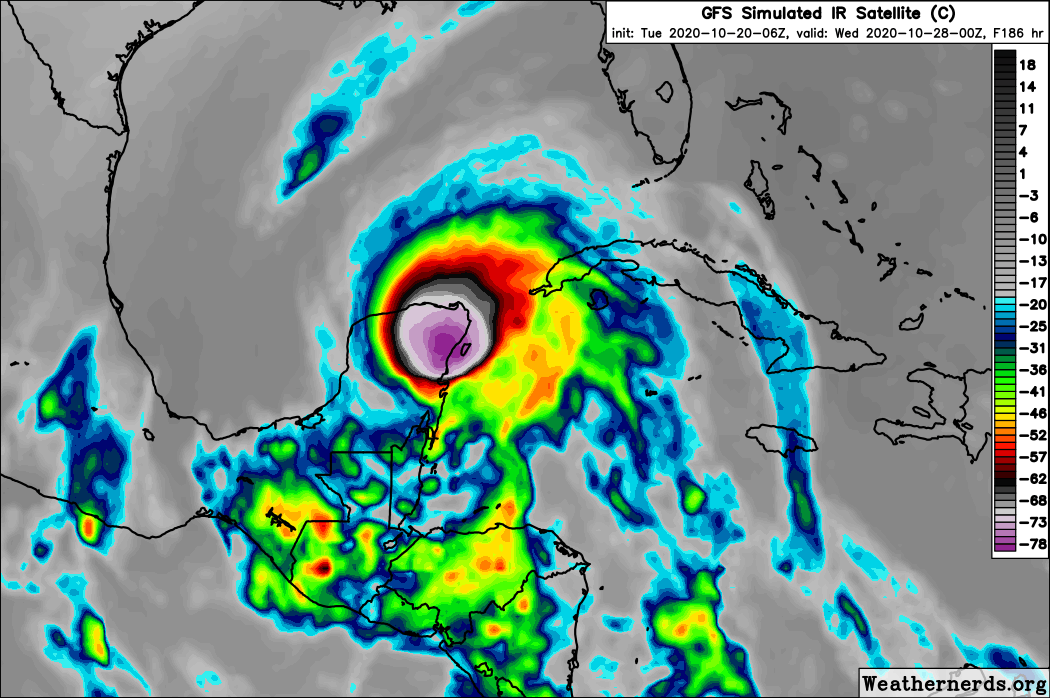
Re: Trough of low pressure in Western Caribbean
Storm formation at 138 hours, followed by very slow but steady strengthening near Yucatan. Here we go again...

2 likes

Re: Trough of low pressure in Western Caribbean
Looks like this broad sloppy mess in the WCar sticks around long enough for a TC to concentrate within in. This is a different scenario from a much smaller and more compact precursor low that the GFS/GFS-Para had until a few days ago, which facilitated quicker development and the system leaving the Caribbean sooner as well. With this much broader setup, who knows how long we’ll be waiting for something to concentrate out of this. It could be in the WCar, it could be in the Gulf, it could either be late-season slop or a RIing major...or nothing at all.
1 likes
Irene '11 Sandy '12 Hermine '16 5/15/2018 Derecho Fay '20 Isaias '20 Elsa '21 Henri '21 Ida '21
I am only a meteorology enthusiast who knows a decent amount about tropical cyclones. Look to the professional mets, the NHC, or your local weather office for the best information.
I am only a meteorology enthusiast who knows a decent amount about tropical cyclones. Look to the professional mets, the NHC, or your local weather office for the best information.
-
GeneratorPower

- S2K Supporter
- Posts: 1648
- Age: 44
- Joined: Sun Dec 18, 2005 11:48 pm
- Location: Huntsville, AL
Re: Trough of low pressure in Western Caribbean
aspen wrote:Looks like this broad sloppy mess in the WCar sticks around long enough for a TC to concentrate within in. This is a different scenario from a much smaller and more compact precursor low that the GFS/GFS-Para had until a few days ago, which facilitated quicker development and the system leaving the Caribbean sooner as well. With this much broader setup, who knows how long we’ll be waiting for something to concentrate out of this. It could be in the WCar, it could be in the Gulf, it could either be late-season slop or a RIing major...or nothing at all.
Or keeps getting pushed out in time to June 2021.
2 likes
Re: Trough of low pressure in Western Caribbean
Lol the GFS has C4 Hurricane Zeta and C1 Hurricane Eta in the Caribbean at the end of its 06z run. Like that’s going to happen.
0 likes
Irene '11 Sandy '12 Hermine '16 5/15/2018 Derecho Fay '20 Isaias '20 Elsa '21 Henri '21 Ida '21
I am only a meteorology enthusiast who knows a decent amount about tropical cyclones. Look to the professional mets, the NHC, or your local weather office for the best information.
I am only a meteorology enthusiast who knows a decent amount about tropical cyclones. Look to the professional mets, the NHC, or your local weather office for the best information.
Re: Trough of low pressure in Western Caribbean
aspen wrote:Lol the GFS has C4 Hurricane Zeta and C1 Hurricane Eta in the Caribbean at the end of its 06z run. Like that’s going to happen.
Ya never know....but whatever...I gotta go to work....yall have a great day...
0 likes

Re: Trough of low pressure in Western Caribbean
We have 51 pages of phantom watching but it does give us something to talk about.
1 likes
-
AutoPenalti
- Category 5
- Posts: 3949
- Age: 27
- Joined: Mon Aug 17, 2015 4:16 pm
- Location: Ft. Lauderdale, Florida
Re: Trough of low pressure in Western Caribbean
With the latest update, I’d give it 2 extra days before giving GFS the axe.
0 likes
The posts in this forum are NOT official forecasts and should not be used as such. They are just the opinion of the poster and may or may not be backed by sound meteorological data. They are NOT endorsed by any professional institution or STORM2K. For official information, please refer to products from the NHC and NWS.
Model Runs Cheat Sheet:
GFS (5:30 AM/PM, 11:30 AM/PM)
HWRF, GFDL, UKMET, NAVGEM (6:30-8:00 AM/PM, 12:30-2:00 AM/PM)
ECMWF (1:45 AM/PM)
TCVN is a weighted averaged
Who is online
Users browsing this forum: Bing [Bot], Google Adsense [Bot], Long John and 201 guests