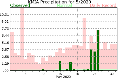
Trough of low pressure in Western Caribbean (Is Invest 95L)

This is the general tropical discussion area. Anyone can take their shot at predicting a storms path.

Moderator: S2k Moderators

Forum rules

The posts in this forum are NOT official forecasts and should not be used as such. They are just the opinion of the poster and may or may not be backed by sound meteorological data. They are NOT endorsed by any professional institution or STORM2K. For official information, please refer to products from the National Hurricane Center and National Weather Service.

Help Support Storm2K
Message
Author
Nuno
Category 2
Category 2
Posts: 529
Joined: Fri Aug 30, 2019 8:35 am
Location: Coral Gables, FL

Re: Trough of low pressure in Western Caribbean

#1101 Postby Nuno » Wed Oct 21, 2020 11:05 am

TheStormExpert wrote:
Nuno wrote:
TheStormExpert wrote:I’m guessing you don’t live in South Florida, this past May was just as wet as this October with around a foot of rain here.


https://www.weather.gov/images/mfl/rtimages/cliplot/KMIA202005plotP-2.png
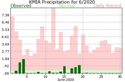
https://www.weather.gov/images/mfl/rtimages/cliplot/KMIA202006plotP-2.png

I've lived in South Florida my whole life and have seen a gradual shift to a later wet-season. May had a few days at the end of the month that was excessive, but otherwise the 45 day period from Mid-May to late June wasn't as wet. We're seeing a lot of extreme precipitation events that cause monthly averages to match up to climatological norms, but it's bunched up in extreme rainfall days. Take a peek at https://www.weather.gov/mfl/mia_cliplot you can see a pattern emerging if you look at the past few May and June totals. I'll take this to the Florida weather thread from here on out so we're not off topic.

Where about in South Florida do you live? I’m in Palm Beach Gardens near West Palm Beach.


Coastal Dade county.
0 likes   
Andrew (1992), Irene (1999), Frances (2004), Katrina (2005), Wilma (2005), Fay (2008), Irma (2017), Eta (2020), Ian (2022)

NXStumpy_Robothing
Category 1
Category 1
Posts: 325
Age: 23
Joined: Fri Jun 05, 2020 11:50 pm
Location: North Georgia

Re: Trough of low pressure in Western Caribbean

#1102 Postby NXStumpy_Robothing » Wed Oct 21, 2020 1:08 pm

Tropical Weather Outlook
NWS National Hurricane Center Miami FL
200 PM EDT Wed Oct 21 2020

For the North Atlantic...Caribbean Sea and the Gulf of Mexico:

The National Hurricane Center is issuing advisories on Hurricane
Epsilon, located over the central Atlantic a few hundred miles
east-southeast of Bermuda.

1. A trough of low pressure extending from the southwestern to the
northwestern Caribbean Sea is producing a large area of disorganized
showers and thunderstorms. Any development of this system is
expected to be slow over the next several days as the system passes
near western or central Cuba, the Florida Straits, and the Bahamas.
Regardless of development, locally heavy rainfall is possible in
those areas and South Florida at times through the weekend.
* Formation chance through 48 hours...low...near 0 percent.
* Formation chance through 5 days...low...20 percent.

Forecaster Reinhart/Blake


Guess who's back? (back again?)
1 likes   
Undergraduate Meteorology Student, Georgia Institute of Technology

User avatar
cycloneye
Admin
Admin
Posts: 139150
Age: 67
Joined: Thu Oct 10, 2002 10:54 am
Location: San Juan, Puerto Rico

Re: Trough of low pressure in Western Caribbean

#1103 Postby cycloneye » Wed Oct 21, 2020 1:11 pm

NXStumpy_Robothing wrote:
Tropical Weather Outlook
NWS National Hurricane Center Miami FL
200 PM EDT Wed Oct 21 2020

For the North Atlantic...Caribbean Sea and the Gulf of Mexico:

The National Hurricane Center is issuing advisories on Hurricane
Epsilon, located over the central Atlantic a few hundred miles
east-southeast of Bermuda.

1. A trough of low pressure extending from the southwestern to the
northwestern Caribbean Sea is producing a large area of disorganized
showers and thunderstorms. Any development of this system is
expected to be slow over the next several days as the system passes
near western or central Cuba, the Florida Straits, and the Bahamas.
Regardless of development, locally heavy rainfall is possible in
those areas and South Florida at times through the weekend.
* Formation chance through 48 hours...low...near 0 percent.
* Formation chance through 5 days...low...20 percent.

Forecaster Reinhart/Blake


Guess who's back? (back again?)


Image
1 likes   
Visit the Caribbean-Central America Weather Thread where you can find at first post web cams,radars
and observations from Caribbean basin members Click Here

User avatar
Weatherboy1
Category 5
Category 5
Posts: 1167
Age: 48
Joined: Mon Jul 05, 2004 1:50 pm
Location: Jupiter, FL

Re: Trough of low pressure in Western Caribbean

#1104 Postby Weatherboy1 » Wed Oct 21, 2020 1:13 pm

If at first you don’t succeed as an area of low pressure trying to get noticed, try try again? :)
3 likes   

User avatar
kevin
Category 5
Category 5
Posts: 1769
Age: 25
Joined: Wed Aug 28, 2019 4:35 am

Re: Trough of low pressure in Western Caribbean

#1105 Postby kevin » Wed Oct 21, 2020 1:18 pm

Even if this potential future Zeta never forms, you gotta give it to him. It's not for lack of trying.
1 likes   

User avatar
SFLcane
S2K Supporter
S2K Supporter
Posts: 9610
Age: 46
Joined: Sat Jun 05, 2010 1:44 pm
Location: Lake Worth Florida

Re: Trough of low pressure in Western Caribbean

#1106 Postby SFLcane » Wed Oct 21, 2020 1:22 pm

Lol... can someone post the hwrf output which covers this disturbance? I only have the nest version for the other tc out in the Atl. Look bottom left

Image
Last edited by SFLcane on Wed Oct 21, 2020 1:27 pm, edited 1 time in total.
0 likes   

User avatar
ElectricStorm
Category 5
Category 5
Posts: 4573
Age: 23
Joined: Tue Aug 13, 2019 11:23 pm
Location: Skiatook, OK / Norman, OK

Re: Trough of low pressure in Western Caribbean

#1107 Postby ElectricStorm » Wed Oct 21, 2020 1:25 pm

cycloneye wrote:
NXStumpy_Robothing wrote:
Tropical Weather Outlook
NWS National Hurricane Center Miami FL
200 PM EDT Wed Oct 21 2020

For the North Atlantic...Caribbean Sea and the Gulf of Mexico:

The National Hurricane Center is issuing advisories on Hurricane
Epsilon, located over the central Atlantic a few hundred miles
east-southeast of Bermuda.

1. A trough of low pressure extending from the southwestern to the
northwestern Caribbean Sea is producing a large area of disorganized
showers and thunderstorms. Any development of this system is
expected to be slow over the next several days as the system passes
near western or central Cuba, the Florida Straits, and the Bahamas.
Regardless of development, locally heavy rainfall is possible in
those areas and South Florida at times through the weekend.
* Formation chance through 48 hours...low...near 0 percent.
* Formation chance through 5 days...low...20 percent.

Forecaster Reinhart/Blake


Guess who's back? (back again?)


https://i.imgur.com/hcKELGh.png

Here we go again ...
0 likes   
I am in no way a professional. Take what I say with a grain of salt as I could be totally wrong. Please refer to the NHC, NWS, or SPC for official information.

Boomer Sooner!

User avatar
AnnularCane
S2K Supporter
S2K Supporter
Posts: 2635
Joined: Thu Jun 08, 2006 9:18 am
Location: Wytheville, VA

Re: Trough of low pressure in Western Caribbean

#1108 Postby AnnularCane » Wed Oct 21, 2020 1:52 pm

:lol:

Wake me when Zeta forms. :sleeping:
0 likes   

User avatar
gatorcane
S2K Supporter
S2K Supporter
Posts: 23499
Age: 46
Joined: Sun Mar 13, 2005 3:54 pm
Location: Boca Raton, FL

Re: Trough of low pressure in Western Caribbean

#1109 Postby gatorcane » Wed Oct 21, 2020 2:39 pm

We may find that this system actually pulls moisture away from Florida as we will be in the dry side. That would be some good news with the ton of rainfall we have received this month.
0 likes   

Sanibel
Category 5
Category 5
Posts: 10348
Joined: Mon Aug 30, 2004 11:06 pm
Location: Offshore SW Florida

Trough of low pressure in Western Caribbean

#1110 Postby Sanibel » Wed Oct 21, 2020 2:43 pm

Epsilon has the whole west Atlantic entrained...

It appears to me that something is trying to form in the western Caribbean...
0 likes   

User avatar
ElectricStorm
Category 5
Category 5
Posts: 4573
Age: 23
Joined: Tue Aug 13, 2019 11:23 pm
Location: Skiatook, OK / Norman, OK

Re: Trough of low pressure in Western Caribbean

#1111 Postby ElectricStorm » Wed Oct 21, 2020 4:42 pm

There is an area of low shear down there. If it can track with the disturbance, I can see this try to spin up once it gets in the Bahamas. 56 pages in... and we're still not done folks :lol:
Image
2 likes   
I am in no way a professional. Take what I say with a grain of salt as I could be totally wrong. Please refer to the NHC, NWS, or SPC for official information.

Boomer Sooner!

User avatar
Blown Away
S2K Supporter
S2K Supporter
Posts: 9863
Joined: Wed May 26, 2004 6:17 am

Re: Trough of low pressure in Western Caribbean

#1112 Postby Blown Away » Wed Oct 21, 2020 5:10 pm

Image
Latest...
0 likes   
Hurricane Eye Experience: David 79, Irene 99, Frances 04, Jeanne 04, Wilma 05...
Hurricane Brush Experience: Andrew 92, Erin 95, Floyd 99, Matthew 16, Irma 17, Ian 22, Nicole 22…

underthwx
Category 5
Category 5
Posts: 1928
Joined: Sat Jul 30, 2011 2:14 pm
Location: Brazoria County Texas

Re: Trough of low pressure in Western Caribbean

#1113 Postby underthwx » Wed Oct 21, 2020 5:57 pm

I just got off work....checked the NHC.....it's changed since it disappeared this morning....
0 likes   

User avatar
cycloneye
Admin
Admin
Posts: 139150
Age: 67
Joined: Thu Oct 10, 2002 10:54 am
Location: San Juan, Puerto Rico

Re: Trough of low pressure in Western Caribbean

#1114 Postby cycloneye » Wed Oct 21, 2020 6:22 pm

8 PM:

A trough of low pressure located over the western Caribbean Sea
is producing a large area of disorganized showers and thunderstorms.
Development of this system is unlikely to occur during the next few
days as it passes near western or central Cuba, and moves over the
Straits of Florida. By late weekend or early next week, however,
some slow development of this system is possible while it moves
generally northeastward near the central Bahamas. Regardless of
development, locally heavy rainfall is possible over portions of
Cuba, South Florida, and the Bahamas through early next week.
* Formation chance through 48 hours...low...near 0 percent.
* Formation chance through 5 days...low...20 percent.
0 likes   
Visit the Caribbean-Central America Weather Thread where you can find at first post web cams,radars
and observations from Caribbean basin members Click Here

LarryWx
Category 5
Category 5
Posts: 5708
Joined: Sun Sep 07, 2003 2:04 pm
Location: GA

Re: Trough of low pressure in Western Caribbean

#1115 Postby LarryWx » Wed Oct 21, 2020 7:44 pm

12Z UKMET likes this enough to make it a TD hours 120+ but it is weaker than the prior run's 997 at the end:

NEW TROPICAL CYCLONE FORECAST TO DEVELOP AFTER 120 HOURS
FORECAST POSITION AT T+120 : 25.5N 78.0W

LEAD CENTRAL MAXIMUM WIND
VERIFYING TIME TIME POSITION PRESSURE (MB) SPEED (KNOTS)
-------------- ---- -------- ------------- -------------
1200UTC 26.10.2020 120 25.5N 78.0W 1007 31
0000UTC 27.10.2020 132 26.7N 75.5W 1007 28
1200UTC 27.10.2020 144 26.9N 75.4W 1007 29

Interestingly, the TD becomes nearly stalled at 1444 as a new 500 mb high develops to its west and imparts a northerly 500 mb flow:

Image

Rainfall for entire run: lots of rainfall for S FL

Image
0 likes   
Personal Forecast Disclaimer:
The posts in this forum are NOT official forecasts and should not be used as such. They are just the opinion of the poster and may or may not be backed by sound meteorological data. They are NOT endorsed by any professional institution or storm2k.org. For official information, please refer to the NHC and NWS products.

User avatar
ElectricStorm
Category 5
Category 5
Posts: 4573
Age: 23
Joined: Tue Aug 13, 2019 11:23 pm
Location: Skiatook, OK / Norman, OK

Re: Trough of low pressure in Western Caribbean

#1116 Postby ElectricStorm » Wed Oct 21, 2020 10:09 pm

I know it's way early but looking at the NHC TWO graphic, IF this does indeed develop over the Bahamas, it may try to make a run at Bermuda so it could be yet another storm they need to keep an eye on. Again, it's way early, but just something to keep an eye on.
0 likes   
I am in no way a professional. Take what I say with a grain of salt as I could be totally wrong. Please refer to the NHC, NWS, or SPC for official information.

Boomer Sooner!

User avatar
ElectricStorm
Category 5
Category 5
Posts: 4573
Age: 23
Joined: Tue Aug 13, 2019 11:23 pm
Location: Skiatook, OK / Norman, OK

Re: Trough of low pressure in Western Caribbean

#1117 Postby ElectricStorm » Wed Oct 21, 2020 11:11 pm

0z GFS doesn't develop this.
1 likes   
I am in no way a professional. Take what I say with a grain of salt as I could be totally wrong. Please refer to the NHC, NWS, or SPC for official information.

Boomer Sooner!

LarryWx
Category 5
Category 5
Posts: 5708
Joined: Sun Sep 07, 2003 2:04 pm
Location: GA

Re: Trough of low pressure in Western Caribbean

#1118 Postby LarryWx » Thu Oct 22, 2020 12:39 am

0Z UKMET still develops this into a TD but it is further east
0 likes   
Personal Forecast Disclaimer:
The posts in this forum are NOT official forecasts and should not be used as such. They are just the opinion of the poster and may or may not be backed by sound meteorological data. They are NOT endorsed by any professional institution or storm2k.org. For official information, please refer to the NHC and NWS products.

User avatar
ElectricStorm
Category 5
Category 5
Posts: 4573
Age: 23
Joined: Tue Aug 13, 2019 11:23 pm
Location: Skiatook, OK / Norman, OK

Re: Trough of low pressure in Western Caribbean

#1119 Postby ElectricStorm » Thu Oct 22, 2020 12:52 am

1. A trough of low pressure located over the western Caribbean Sea
is producing a large area of disorganized showers and thunderstorms
which primarily extend near Jamaica, the Cayman Islands, and Cuba.
Development of this system is unlikely to occur during the next few
days as it passes near western Cuba and moves over the Straits of
Florida. By late this weekend or early next week, however, some
slow development is possible while the system moves generally
northeastward from near the northwestern Bahamas toward the western
Atlantic. Regardless of development, locally heavy rainfall is
possible over portions of Cuba, South Florida, and the Bahamas
through early next week.
* Formation chance through 48 hours...low...near 0 percent.
* Formation chance through 5 days...low...20 percent.

Image
0 likes   
I am in no way a professional. Take what I say with a grain of salt as I could be totally wrong. Please refer to the NHC, NWS, or SPC for official information.

Boomer Sooner!

User avatar
SFLcane
S2K Supporter
S2K Supporter
Posts: 9610
Age: 46
Joined: Sat Jun 05, 2010 1:44 pm
Location: Lake Worth Florida

Re: Trough of low pressure in Western Caribbean

#1120 Postby SFLcane » Thu Oct 22, 2020 5:53 am

Convection flaring up down in the nw Caribbean this morning.

 https://twitter.com/jacksillin/status/1319221451103326208


2 likes   


Return to “Talkin' Tropics”

Who is online

Users browsing this forum: Homie J, JaviT, StPeteMike and 178 guests