This might be the smoking gun.
Moderator: S2k Moderators


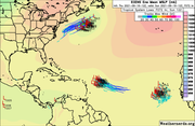
AlphaToOmega wrote:Let me ask: does this look like an inactive September?
https://i.postimg.cc/xjmC2Xgc/two-atl-5d0.png
The chance of none of these developing is (100% - 80%) * (100% - 70%) * (100% - 20%) = 4.8%
AlphaToOmega wrote:Let me ask: does this look like an inactive September?
https://i.postimg.cc/xjmC2Xgc/two-atl-5d0.png
The chance of none of these developing is (100% - 80%) * (100% - 70%) * (100% - 20%) = 4.8%
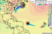
hurricanes1234 wrote:AlphaToOmega wrote:Let me ask: does this look like an inactive September?
https://i.postimg.cc/xjmC2Xgc/two-atl-5d0.png
The chance of none of these developing is (100% - 80%) * (100% - 70%) * (100% - 20%) = 4.8%
But are any of those areas actually doing anything?
Everything out in the open Atlantic post-Larry has been hitting a wall or just falling apart entirely. Even Larry itself struggled in a marginal atmosphere and a marginal thermodynamic environment. Since the month only has 2 weeks left, a bunch of hurricanes forming and going bonkers across the basin (so as to meet the definition of a hyperactive September) when the intraseasonal state is pretty bad would be rather surprising at this point.
2021 does seem to be a year with a strong intraseasonal influence and it's reasonable to speculate that October could be more active based on the enhanced MJO predicted to arrive during the month. But IMO a hyperactive September is off the table. Probably a couple more systems and even a hurricane or two which would make the month average/slightly above-average at most but not hyperactive.
Category5Kaiju wrote:hurricanes1234 wrote:AlphaToOmega wrote:Let me ask: does this look like an inactive September?
https://i.postimg.cc/xjmC2Xgc/two-atl-5d0.png
The chance of none of these developing is (100% - 80%) * (100% - 70%) * (100% - 20%) = 4.8%
But are any of those areas actually doing anything?
Everything out in the open Atlantic post-Larry has been hitting a wall or just falling apart entirely. Even Larry itself struggled in a marginal atmosphere and a marginal thermodynamic environment. Since the month only has 2 weeks left, a bunch of hurricanes forming and going bonkers across the basin (so as to meet the definition of a hyperactive September) when the intraseasonal state is pretty bad would be rather surprising at this point.
2021 does seem to be a year with a strong intraseasonal influence and it's reasonable to speculate that October could be more active based on the enhanced MJO predicted to arrive during the month. But IMO a hyperactive September is off the table. Probably a couple more systems and even a hurricane or two which would make the month average/slightly above-average at most but not hyperactive.
Yeah I agree; I just am not sure if September is going to be as active as we once thought (while August performed better than expected in contrast). Given our state, I do think that October will feature activity pick up once again, and honestly that actually is a bit concerning given how climo favors west based activity then and in recent years the strongest storm of the season for some reason happened after late September. In fact, I am going to be bold and predict that I expect to see at least two major hurricanes occur during October. With this season doing well in August and meager in September (with the Pacific basins underperforming substantially), something tells me that this is simply the calm before the storm and that we are in for a fiercely backloaded year (with activity possibly lasting into November). That’s just my take though.
Hammy wrote:AlphaToOmega wrote:Let me ask: does this look like an inactive September?
https://i.postimg.cc/xjmC2Xgc/two-atl-5d0.png
The chance of none of these developing is (100% - 80%) * (100% - 70%) * (100% - 20%) = 4.8%
There's a decent chance (probably higher than the maps indicate) that none of these develop. I don't like using the outlook maps as a determinant of activity because they can always give a false impression--remember when we had five circled areas just a few days ago.

AlphaToOmega wrote:Category5Kaiju wrote:hurricanes1234 wrote:
But are any of those areas actually doing anything?
Everything out in the open Atlantic post-Larry has been hitting a wall or just falling apart entirely. Even Larry itself struggled in a marginal atmosphere and a marginal thermodynamic environment. Since the month only has 2 weeks left, a bunch of hurricanes forming and going bonkers across the basin (so as to meet the definition of a hyperactive September) when the intraseasonal state is pretty bad would be rather surprising at this point.
2021 does seem to be a year with a strong intraseasonal influence and it's reasonable to speculate that October could be more active based on the enhanced MJO predicted to arrive during the month. But IMO a hyperactive September is off the table. Probably a couple more systems and even a hurricane or two which would make the month average/slightly above-average at most but not hyperactive.
Yeah I agree; I just am not sure if September is going to be as active as we once thought (while August performed better than expected in contrast). Given our state, I do think that October will feature activity pick up once again, and honestly that actually is a bit concerning given how climo favors west based activity then and in recent years the strongest storm of the season for some reason happened after late September. In fact, I am going to be bold and predict that I expect to see at least two major hurricanes occur during October. With this season doing well in August and meager in September (with the Pacific basins underperforming substantially), something tells me that this is simply the calm before the storm and that we are in for a fiercely backloaded year (with activity possibly lasting into November). That’s just my take though.
Do not assume that September will be lackluster just because of not-so-stellar storm performances. By that logic, Hurricane Matthew, a September hurricane, should not have become a major hurricane.
AlphaToOmega wrote:Maybe the bears have some magical crystal ball that is better than the GFS, GEFS, ECMWF, and ECENS. I would be very impressed.
https://i.postimg.cc/CRKpDBDB/ECMF-phase-51m-full.gif
https://i.postimg.cc/qthfbP1p/ensplume-full.gif
https://i.postimg.cc/zHLDKqBW/ecens-2021-09-16-12-Z-072-50-258-0-350-MSLP-Surface-tracks-lows.png
https://i.postimg.cc/phcXmm2R/gefs-2021-09-16-12-Z-072-50-258-0-350-MSLP-Surface-tracks-lows.png
CyclonicFury wrote:AlphaToOmega wrote:Maybe the bears have some magical crystal ball that is better than the GFS, GEFS, ECMWF, and ECENS. I would be very impressed.
https://i.postimg.cc/CRKpDBDB/ECMF-phase-51m-full.gif
https://i.postimg.cc/qthfbP1p/ensplume-full.gif
https://i.postimg.cc/zHLDKqBW/ecens-2021-09-16-12-Z-072-50-258-0-350-MSLP-Surface-tracks-lows.png
https://i.postimg.cc/phcXmm2R/gefs-2021-09-16-12-Z-072-50-258-0-350-MSLP-Surface-tracks-lows.png
Most of those members are very weak, and the EPS signal is a lot less impressive than it was a few days ago.
AlphaToOmega wrote:Category5Kaiju wrote:hurricanes1234 wrote:
But are any of those areas actually doing anything?
Everything out in the open Atlantic post-Larry has been hitting a wall or just falling apart entirely. Even Larry itself struggled in a marginal atmosphere and a marginal thermodynamic environment. Since the month only has 2 weeks left, a bunch of hurricanes forming and going bonkers across the basin (so as to meet the definition of a hyperactive September) when the intraseasonal state is pretty bad would be rather surprising at this point.
2021 does seem to be a year with a strong intraseasonal influence and it's reasonable to speculate that October could be more active based on the enhanced MJO predicted to arrive during the month. But IMO a hyperactive September is off the table. Probably a couple more systems and even a hurricane or two which would make the month average/slightly above-average at most but not hyperactive.
Yeah I agree; I just am not sure if September is going to be as active as we once thought (while August performed better than expected in contrast). Given our state, I do think that October will feature activity pick up once again, and honestly that actually is a bit concerning given how climo favors west based activity then and in recent years the strongest storm of the season for some reason happened after late September. In fact, I am going to be bold and predict that I expect to see at least two major hurricanes occur during October. With this season doing well in August and meager in September (with the Pacific basins underperforming substantially), something tells me that this is simply the calm before the storm and that we are in for a fiercely backloaded year (with activity possibly lasting into November). That’s just my take though.
Do not assume that September will be lackluster just because of not-so-stellar storm performances. By that logic, Hurricane Matthew, a September hurricane, should not have become a major hurricane.
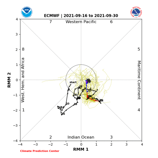
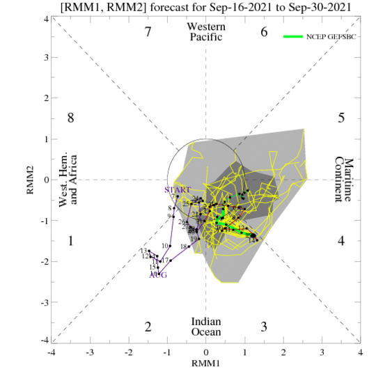
AlphaToOmega wrote:Most GEFS and ECENS ensemble members show both Invests 95L and 96L getting to tropical storm status. For the MJO forecasts, both the GFS and ECMWF show a retrogression of the MJO, which would keep us in Phase III for longer. Phase III is favorable for tropical cyclogenesis in the Atlantic. Cape Verde development is becoming less likely by the day, but that just means Invest 95L is likely to develop farther west. Unless you want to say both the GFS and ECMWF keeping the MJO in favorable Phase III is a common bias both of them have, I am still convinced September is going to be active.

Category5Kaiju wrote:If it happens I'll laugh, but what if...just what if...October ends up as a more active month than September, with more ACE, majors, hurricanes, and named storms?


Ubuntwo wrote:EPS does not propagate the MJO. Has several kelvin waves passing across the basin. Verbatim, this would be an active mid-late October following a pause earlier that month.
https://twitter.com/AndyHazelton/status/1438612786385498113
Users browsing this forum: duilaslol, Iceresistance, mixedDanilo.E, pepecool20 and 208 guests


