There are three AoIs in the Atlantic, which might develop into Peter, Victor, and Wanda. One of those might become a hurricane, which would add to the storm and hurricane totals.
After watching hurricanetrack's latest update, it seems like activity count continue into October and November with barely a lull in sight. The EPS shows a continuation of the African Standing Wave AND -VP anomalies over the Atlantic throughout October into the start of Nvoember. The EPS is the model with the highest skill for intraseasonal variation, so this is something worth nothing. As always, the CFS continues to show favorable VP and MSLP patterns throughout October. The fact that both the EPS and CFS show these patterns is a clear indication that October will very likely be another very active month.
TL;DR: All indicators point to a very active October; and those in hurricane-prone areas should be especially prepared, for October activity is primarily in the western basin!
2021 Indicators: SST's / SAL / MSLP / Shear / Steering / Instability / Sat Images
Moderator: S2k Moderators
Forum rules

The posts in this forum are NOT official forecasts and should not be used as such. They are just the opinion of the poster and may or may not be backed by sound meteorological data. They are NOT endorsed by any professional institution or STORM2K. For official information, please refer to products from the National Hurricane Center and National Weather Service.
-
AlphaToOmega
- Category 5

- Posts: 1448
- Joined: Sat Jun 26, 2021 10:51 am
- Location: Somewhere in Massachusetts
-
SconnieCane
- Category 4

- Posts: 913
- Joined: Thu Aug 02, 2018 5:29 pm
- Location: Madison, WI
Re: 2021 Indicators: SST's / SAL / MSLP / Shear / Steering / Instability / Sat Images
AlphaToOmega wrote:There are three AoIs in the Atlantic, which might develop into Peter, Victor, and Wanda. One of those might become a hurricane, which would add to the storm and hurricane totals.
After watching hurricanetrack's latest update, it seems like activity count continue into October and November with barely a lull in sight. The EPS shows a continuation of the African Standing Wave AND -VP anomalies over the Atlantic throughout October into the start of Nvoember. The EPS is the model with the highest skill for intraseasonal variation, so this is something worth nothing. As always, the CFS continues to show favorable VP and MSLP patterns throughout October. The fact that both the EPS and CFS show these patterns is a clear indication that October will very likely be another very active month.
TL;DR: All indicators point to a very active October; and those in hurricane-prone areas should be especially prepared, for October activity is primarily in the western basin!
Already happened, along with Rose, hence why we're on Sam. Teresa also came and went in the last few days.
0 likes
-
Category5Kaiju

- Category 5
- Posts: 3360
- Age: 22
- Joined: Thu Dec 24, 2020 12:45 pm
- Location: Seattle
Re: 2021 Indicators: SST's / SAL / MSLP / Shear / Steering / Instability / Sat Images
I never really thought that I would be saying this now (but here I am nevertheless), but let's say we do get Victor and Wanda by September's end. October could conceivably bring some West Atlantic threats and some subtropical action. Imho, seeing 4-6 NSs in October seems plausible. November could bring 2-3 NSs, again with West Atlantic and/or subtropical action. My guess in NS count by this year's end is 25-30. If anything, I would not be surprised to see 2021 rival the named storm count seen in 2005 and 2020 (like in the upper 20s). Can't believe I just said that honestly, but there we go.
3 likes
Unless explicitly stated, all information covered in my posts is based on my opinions and observations. Please refer to a professional meteorologist or an accredited weather research agency otherwise, especially if serious decisions must be made in the event of a potentially life-threatening tropical storm or hurricane.

Re: 2021 Indicators: SST's / SAL / MSLP / Shear / Steering / Instability / Sat Images
Category5Kaiju wrote:I never really thought that I would be saying this now (but here I am nevertheless), but let's say we do get Victor and Wanda by September's end. October could conceivably bring some West Atlantic threats and some subtropical action. Imho, seeing 4-6 NSs in October seems plausible. November could bring 2-3 NSs, again with West Atlantic and/or subtropical action. My guess in NS count by this year's end is 25-30. If anything, I would not be surprised to see 2021 rival the named storm count seen in 2005 and 2020 (like in the upper 20s). Can't believe I just said that honestly, but there we go.
I'm personally thinking 26 named storms, give or take one.
The next major is probably some WCar powerhouse, with a name from the auxiliaries.
0 likes
blonde stacey (xe/xem/xir)
-
AlphaToOmega
- Category 5
- Posts: 1448
- Joined: Sat Jun 26, 2021 10:51 am
- Location: Somewhere in Massachusetts
Re: 2021 Indicators: SST's / SAL / MSLP / Shear / Steering / Instability / Sat Images
Category5Kaiju wrote:I never really thought that I would be saying this now (but here I am nevertheless), but let's say we do get Victor and Wanda by September's end. October could conceivably bring some West Atlantic threats and some subtropical action. Imho, seeing 4-6 NSs in October seems plausible. November could bring 2-3 NSs, again with West Atlantic and/or subtropical action. My guess in NS count by this year's end is 25-30. If anything, I would not be surprised to see 2021 rival the named storm count seen in 2005 and 2020 (like in the upper 20s). Can't believe I just said that honestly, but there we go.
I can see scenarios in which 2021 rivals 2020 and 2005 in terms of hurricane and major hurricane count as well.
If you look at the big picture, none of this is surprising; SSTs in the MDR are near record-breaking levels, VP patterns match those of 2020, and a La Nina + a negative PDO made the Pacific pattern unfavorable, concentrating rising air to the Atlantic.
0 likes
-
Category5Kaiju
- Category 5
- Posts: 3360
- Age: 22
- Joined: Thu Dec 24, 2020 12:45 pm
- Location: Seattle
Re: 2021 Indicators: SST's / SAL / MSLP / Shear / Steering / Instability / Sat Images
But I gotta say, the evolution of the sst anomalies in the basin since this summer is quite impressive. We went from talking about how the MDR was too cool and probably unsupportive of major activity to this (in fact, 2020's MDR was much warmer in the spring than 2021, yet we still basically caught up). Once again, the idea of the MDR and the basin warming up to levels that would support high amounts of activity during a La Nina, -PDO year was upheld as expected this year.
6 likes
Unless explicitly stated, all information covered in my posts is based on my opinions and observations. Please refer to a professional meteorologist or an accredited weather research agency otherwise, especially if serious decisions must be made in the event of a potentially life-threatening tropical storm or hurricane.
-
CyclonicFury

- Category 5
- Posts: 1975
- Age: 25
- Joined: Sun Jul 02, 2017 12:32 pm
- Location: NC
- Contact:
Re: 2021 Indicators: SST's / SAL / MSLP / Shear / Steering / Instability / Sat Images
It's crazy to think 2021 could match 2020's record breaking 10 September storm formations.
6 likes
NCSU B.S. in Meteorology Class of 2021. Tropical weather blogger at http://www.cyclonicfury.com. My forecasts and thoughts are NOT official, for official forecasts please consult the National Hurricane Center.
-
Category5Kaiju
- Category 5
- Posts: 3360
- Age: 22
- Joined: Thu Dec 24, 2020 12:45 pm
- Location: Seattle
Re: 2021 Indicators: SST's / SAL / MSLP / Shear / Steering / Instability / Sat Images
It's also crazy to see how 2 of the naming lists that used to use up the least number of storms during their most active season, Lists 6 and 1, suddenly surpassed the max usage of 3 of the other naming lists (with List 6 even beating List 3). Who knows what will 1 do, but after frequent failures during El Nino years, 1 finally managed to pull off a show during a La Nina year.
2 likes
Unless explicitly stated, all information covered in my posts is based on my opinions and observations. Please refer to a professional meteorologist or an accredited weather research agency otherwise, especially if serious decisions must be made in the event of a potentially life-threatening tropical storm or hurricane.
Re: 2021 Indicators: SST's / SAL / MSLP / Shear / Steering / Instability / Sat Images
Again, it's also crazy that 2021 might possibly obtain the first auxiliary name retirement, since SOME signals possibly point to something menacing in the WCar very soon.
0 likes
blonde stacey (xe/xem/xir)
Re: 2021 Indicators: SST's / SAL / MSLP / Shear / Steering / Instability / Sat Images
Category5Kaiju wrote:It's also crazy to see how 2 of the naming lists that used to use up the least number of storms during their most active season, Lists 6 and 1, suddenly surpassed the max usage of 3 of the other naming lists (with List 6 even beating List 3). Who knows what will 1 do, but after frequent failures during El Nino years, 1 finally managed to pull off a show during a La Nina year.
Which of the 6 lists do you think would be the last to exhaust all the names, do you reckon, buddy boyo?
0 likes
blonde stacey (xe/xem/xir)
-
CyclonicFury
- Category 5
- Posts: 1975
- Age: 25
- Joined: Sun Jul 02, 2017 12:32 pm
- Location: NC
- Contact:
Re: 2021 Indicators: SST's / SAL / MSLP / Shear / Steering / Instability / Sat Images
So far, 5 of the season's 7 hurricanes have become hurricanes in the MDR or Caribbean (Elsa, Grace, Ida, Larry and Sam). Definitely seems to be a deep tropics focused season, more so than most recent years.
8 likes
NCSU B.S. in Meteorology Class of 2021. Tropical weather blogger at http://www.cyclonicfury.com. My forecasts and thoughts are NOT official, for official forecasts please consult the National Hurricane Center.
Re: 2021 Indicators: SST's / SAL / MSLP / Shear / Steering / Instability / Sat Images
CyclonicFury wrote:So far, 5 of the season's 7 hurricanes have become hurricanes in the MDR or Caribbean (Elsa, Grace, Ida, Larry and Sam). Definitely seems to be a deep tropics focused season, more so than most recent years.
Just you wait and see those two new AOIs become hurricanes in the MDR, brah.
0 likes
blonde stacey (xe/xem/xir)
-
AnnularCane

- S2K Supporter

- Posts: 2635
- Joined: Thu Jun 08, 2006 9:18 am
- Location: Wytheville, VA
Re: 2021 Indicators: SST's / SAL / MSLP / Shear / Steering / Instability / Sat Images
Is there enough room in the MDR for the two of them? I mean, there's also Sam. 
4 likes
"But it never rained rain. It never snowed snow. And it never blew just wind. It rained things like soup and juice. It snowed mashed potatoes and green peas. And sometimes the wind blew in storms of hamburgers." -- Judi Barrett, Cloudy with a Chance of Meatballs
-
CyclonicFury
- Category 5
- Posts: 1975
- Age: 25
- Joined: Sun Jul 02, 2017 12:32 pm
- Location: NC
- Contact:
Re: 2021 Indicators: SST's / SAL / MSLP / Shear / Steering / Instability / Sat Images
EPS says we'll need to the Caribbean around October 10!

1 likes
NCSU B.S. in Meteorology Class of 2021. Tropical weather blogger at http://www.cyclonicfury.com. My forecasts and thoughts are NOT official, for official forecasts please consult the National Hurricane Center.

Re: 2021 Indicators: SST's / SAL / MSLP / Shear / Steering / Instability / Sat Images
AnnularCane wrote:Is there enough room in the MDR for the two of them? I mean, there's also Sam.
If future Victor and Wanda are far enough apart from one another, and the westernmost system gets its act together quickly before before running into Sam’s outflow, it’s possible both can become Category 1 hurricanes. Three simultaneous MDR hurricanes in late September…nobody would’ve saw that coming after a slop-filled mid September.
This is like a busier version of 2016, with a peak in late August that includes a Cat 3 and a CONUS hurricane landfall, a bunch of slop storms in the middle of the month, and then a second peak in late September that includes a borderline Cat 4/5.
2 likes
Irene '11 Sandy '12 Hermine '16 5/15/2018 Derecho Fay '20 Isaias '20 Elsa '21 Henri '21 Ida '21
I am only a meteorology enthusiast who knows a decent amount about tropical cyclones. Look to the professional mets, the NHC, or your local weather office for the best information.
I am only a meteorology enthusiast who knows a decent amount about tropical cyclones. Look to the professional mets, the NHC, or your local weather office for the best information.

Re: 2021 Indicators: SST's / SAL / MSLP / Shear / Steering / Instability / Sat Images
Posted this in the Sam thread, reposting here just because of how insane this late-September MDR activity is:
https://twitter.com/splillo/status/1442501622442070019
Edit: Here are all the storms that appeared on the plot (i.e. reached 130+ kt after Sep 25):
Cuba 1910, Nueva Gerona 1917, Cuba 1924, Havana 1926, Bahamas 1929, Cuba 1932, Janet 1955, Helene 1958, Hattie 1961, Flora 1963, Inez 1966, Opal 1995, Mitch 1998, Lenny 1999, Wilma 2005, Joaquin 2015, Matthew 2016, Michael 2018, Lorenzo 2019, Eta 2020, Iota 2020
Last edited by Teban54 on Mon Sep 27, 2021 10:20 am, edited 1 time in total.
2 likes
-
tolakram
- Admin

- Posts: 19165
- Age: 60
- Joined: Sun Aug 27, 2006 8:23 pm
- Location: Florence, KY (name is Mark)
Re: 2021 Indicators: SST's / SAL / MSLP / Shear / Steering / Instability / Sat Images
We won't see cat 5's every year, especially if conditions aren't completely perfect. Sam has been outstanding, doesn't need to be cat 5 to be exceptional.
4 likes
M a r k
- - - - -
Join us in chat: Storm2K Chatroom Invite. Android and IOS apps also available.
The posts in this forum are NOT official forecasts and should not be used as such. Posts are NOT endorsed by any professional institution or STORM2K.org. For official information and forecasts, please refer to NHC and NWS products.
-
AlphaToOmega
- Category 5
- Posts: 1448
- Joined: Sat Jun 26, 2021 10:51 am
- Location: Somewhere in Massachusetts
Re: 2021 Indicators: SST's / SAL / MSLP / Shear / Steering / Instability / Sat Images
The CFSv2 shows favorable VP anomalies throughout October.
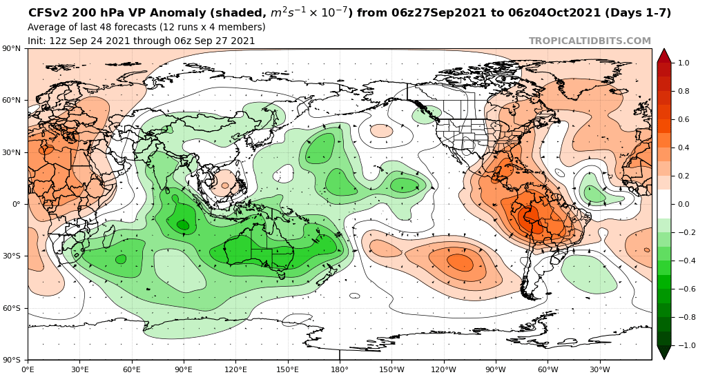
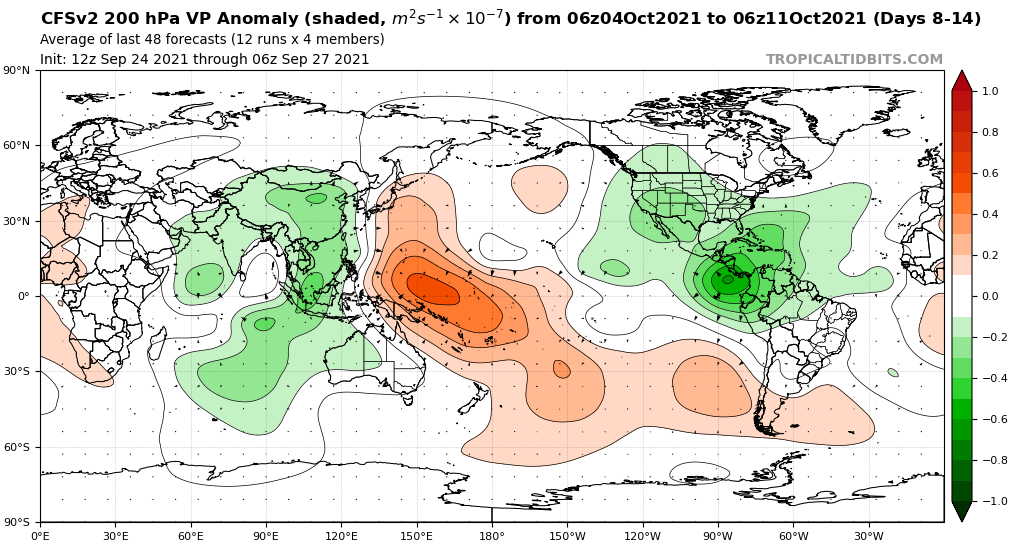
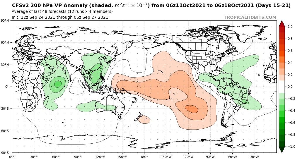
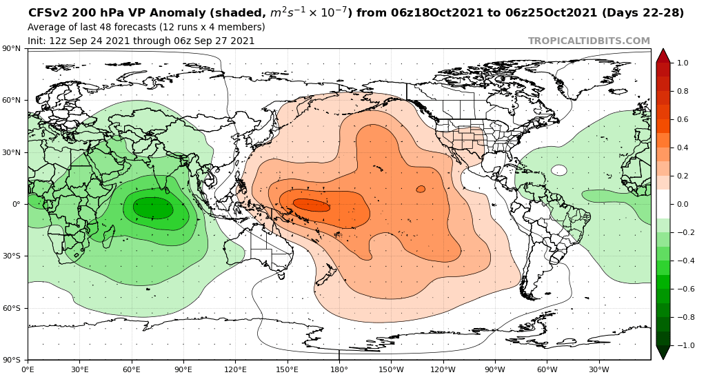
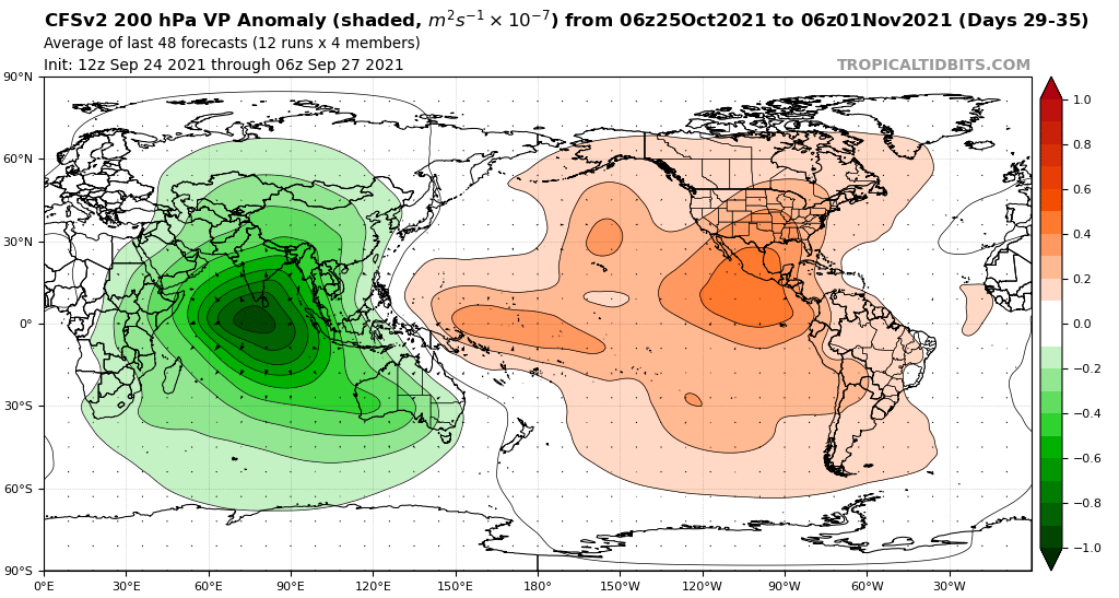
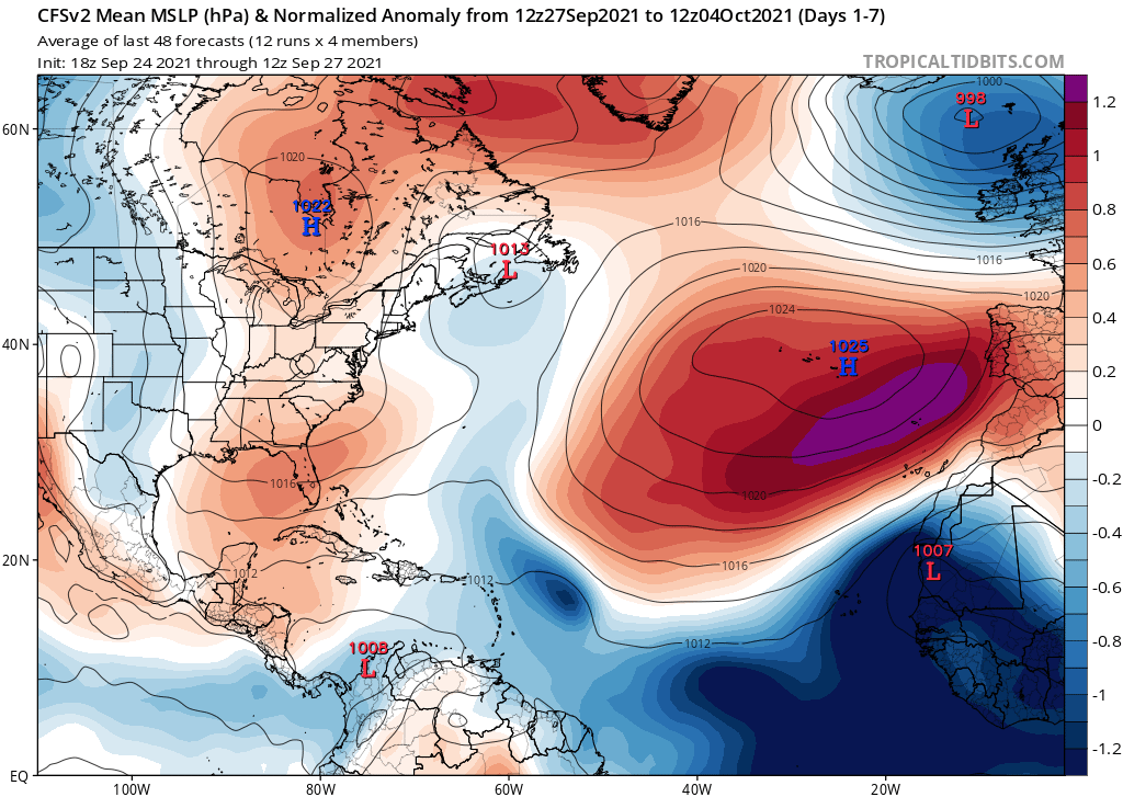
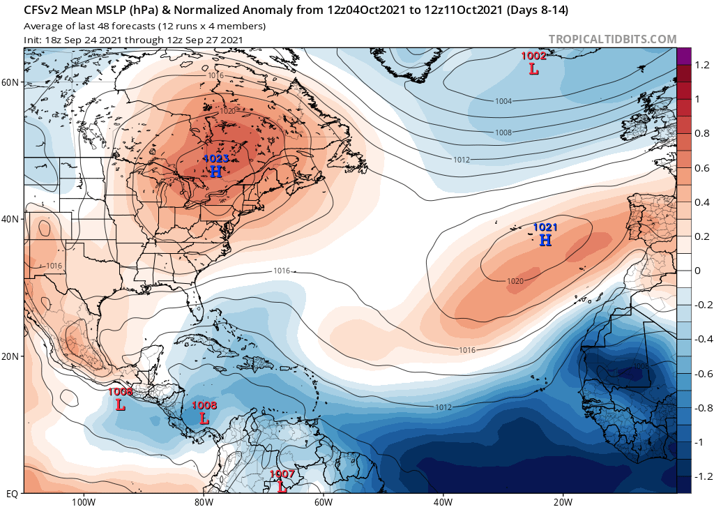
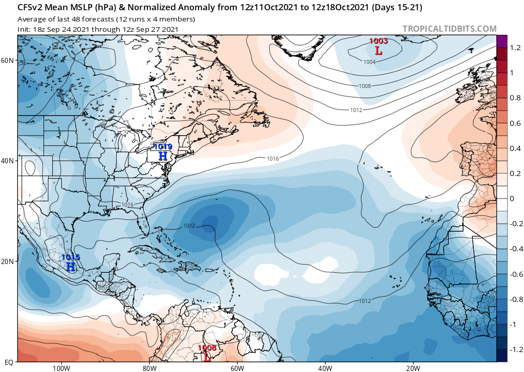
The CFSv2 continues to show below-average MSLP throughout the tropical Atlantic during October.
This continues to support the idea that October is going to be a very busy month.
The CFSv2 continues to show below-average MSLP throughout the tropical Atlantic during October.
This continues to support the idea that October is going to be a very busy month.
4 likes


Re: 2021 Indicators: SST's / SAL / MSLP / Shear / Steering / Instability / Sat Images
AlphaToOmega wrote:The CFSv2 shows favorable VP anomalies throughout October.
The CFSv2 continues to show below-average MSLP throughout the tropical Atlantic during October.
This continues to support the idea that October is going to be a very busy month.
1 likes
Re: 2021 Indicators: SST's / SAL / MSLP / Shear / Steering / Instability / Sat Images
WiscoWx02 wrote:AlphaToOmega wrote:The CFSv2 shows favorable VP anomalies throughout October.
https://i.postimg.cc/0yjhFK1G/cfs-avg-chi200-Mean-global-1.png
https://i.postimg.cc/y8G2H67M/cfs-avg-chi200-Mean-global-2.png
https://i.postimg.cc/QMWwxLtH/cfs-avg-chi200-Mean-global-3.png
https://i.postimg.cc/G2wN4M8z/cfs-avg-chi200-Mean-global-4.png
https://i.postimg.cc/0QY4Dp7v/cfs-avg-chi200-Mean-global-5.png
The CFSv2 continues to show below-average MSLP throughout the tropical Atlantic during October.
https://i.postimg.cc/FFnyGYGX/cfs-avg-mslpa-Norm-Mean-atl-1.png
https://i.postimg.cc/15npdyYn/cfs-avg-mslpa-Norm-Mean-atl-2.png
https://i.postimg.cc/L6czKGry/cfs-avg-mslpa-Norm-Mean-atl-3.png
This continues to support the idea that October is going to be a very busy month.
More and more pronounced of a single as we get closer to October. Definitely having a bad case of deja vu seeing the models show an anticyclone parked over the Caribbean in about a week or two. Very reminiscent of another season I could mention
Which one bro
0 likes
blonde stacey (xe/xem/xir)
Who is online
Users browsing this forum: No registered users and 179 guests