2021 Indicators: SST's / SAL / MSLP / Shear / Steering / Instability / Sat Images
Moderator: S2k Moderators
Forum rules

The posts in this forum are NOT official forecasts and should not be used as such. They are just the opinion of the poster and may or may not be backed by sound meteorological data. They are NOT endorsed by any professional institution or STORM2K. For official information, please refer to products from the National Hurricane Center and National Weather Service.


Re: 2021 Indicators: SST's / SAL / MSLP / Shear / Steering / Instability / Sat Images
Good ole 2020. Don't look at the 18Z GFS run if you wanna keep your sanity by the way. Crazy thing is I kinda believe it. Could be a super busy October with that MJO swinging in that is far darn sure.
1 likes
-
Category5Kaiju

- Category 5

- Posts: 3354
- Age: 22
- Joined: Thu Dec 24, 2020 12:45 pm
- Location: Seattle
Re: 2021 Indicators: SST's / SAL / MSLP / Shear / Steering / Instability / Sat Images
I seriously have this weird gut feeling based on some of the modeling that 2021 could tie or even beat 2005 and/or 2020 in NS count. Bold of me to say, I know, but the VP pattern for October looks extremely favorable. November is a wild card though.
2 likes
Unless explicitly stated, all information covered in my posts is based on my opinions and observations. Please refer to a professional meteorologist or an accredited weather research agency otherwise, especially if serious decisions must be made in the event of a potentially life-threatening tropical storm or hurricane.


Re: 2021 Indicators: SST's / SAL / MSLP / Shear / Steering / Instability / Sat Images
Category5Kaiju wrote:I seriously have this weird gut feeling based on some of the modeling that 2021 could tie or even beat 2005 and/or 2020 in NS count. Bold of me to say, I know, but the VP pattern for October looks extremely favorable. November is a wild card though.
I think it will tbh ngl.
0 likes
blonde stacey (xe/xem/xir)

Re: 2021 Indicators: SST's / SAL / MSLP / Shear / Steering / Instability / Sat Images
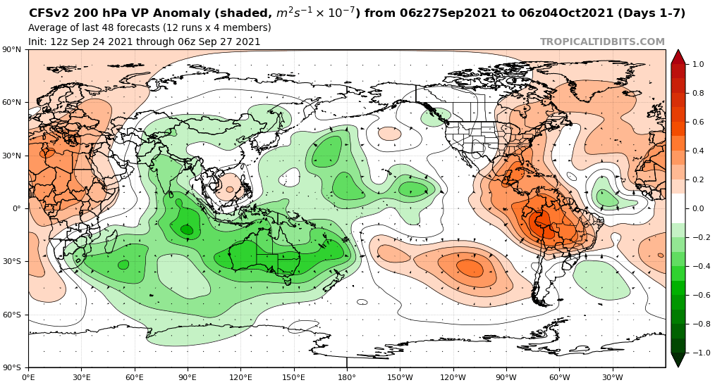
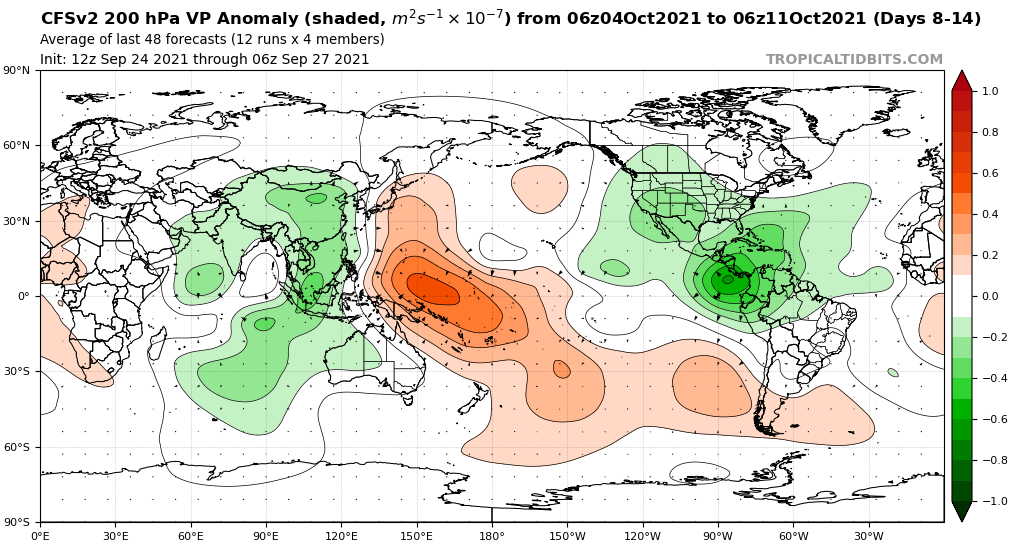
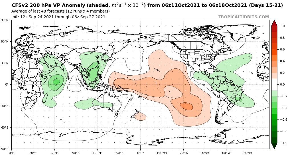
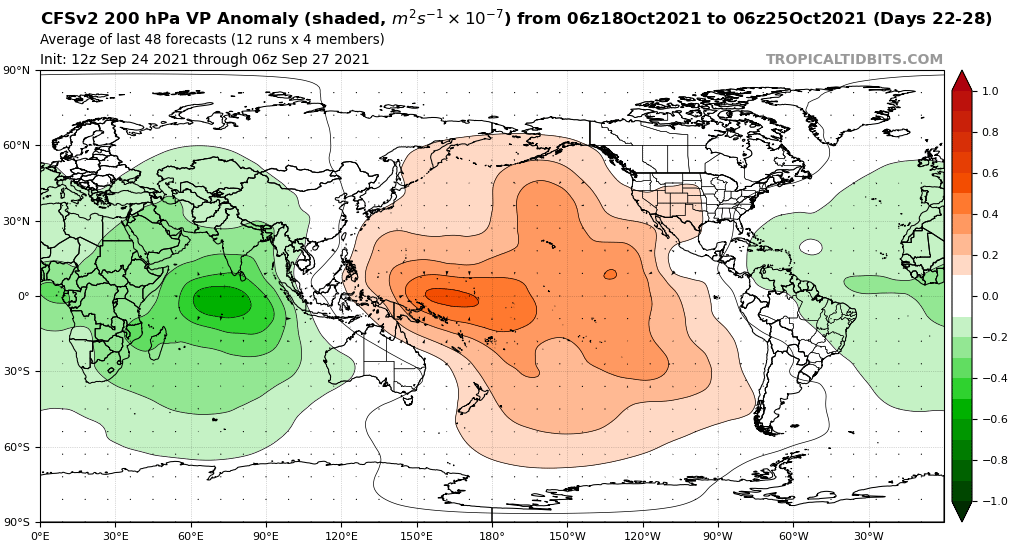
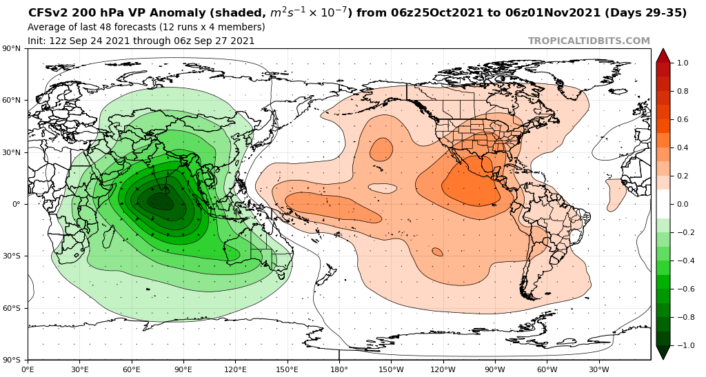
WiscoWx02 wrote:AlphaToOmega wrote:The CFSv2 shows favorable VP anomalies throughout October.
https://i.postimg.cc/0yjhFK1G/cfs-avg-chi200-Mean-global-1.png
https://i.postimg.cc/y8G2H67M/cfs-avg-chi200-Mean-global-2.png
https://i.postimg.cc/QMWwxLtH/cfs-avg-chi200-Mean-global-3.png
https://i.postimg.cc/G2wN4M8z/cfs-avg-chi200-Mean-global-4.png
https://i.postimg.cc/0QY4Dp7v/cfs-avg-chi200-Mean-global-5.png
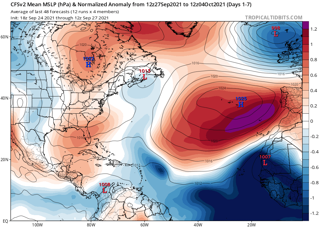
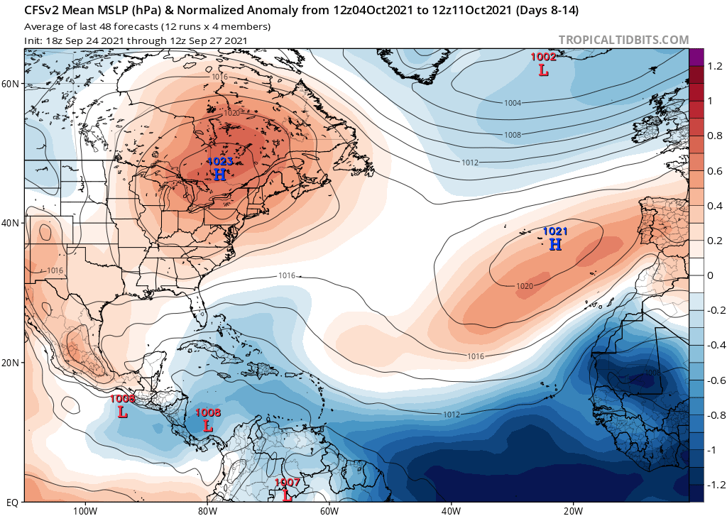
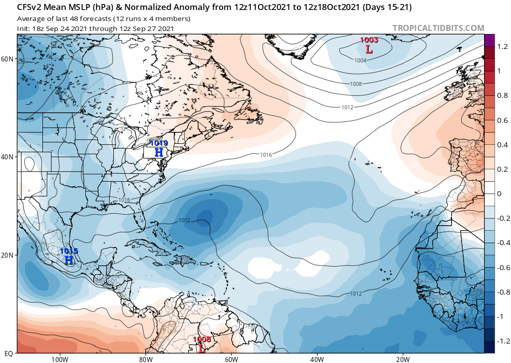
The CFSv2 continues to show below-average MSLP throughout the tropical Atlantic during October.
https://i.postimg.cc/FFnyGYGX/cfs-avg-mslpa-Norm-Mean-atl-1.png
https://i.postimg.cc/15npdyYn/cfs-avg-mslpa-Norm-Mean-atl-2.png
https://i.postimg.cc/L6czKGry/cfs-avg-mslpa-Norm-Mean-atl-3.png
This continues to support the idea that October is going to be a very busy month.
More and more pronounced of a single as we get closer to October. Definitely having a bad case of deja vu seeing the models show an anticyclone parked over the Caribbean in about a week or two. Very reminiscent of another season I could mention
That kind of forcing screams a congo line of major hurricanes
0 likes
-
cycloneye

- Admin

- Posts: 139051
- Age: 67
- Joined: Thu Oct 10, 2002 10:54 am
- Location: San Juan, Puerto Rico
Re: 2021 Indicators: SST's / SAL / MSLP / Shear / Steering / Instability / Sat Images
2 likes
Visit the Caribbean-Central America Weather Thread where you can find at first post web cams,radars
and observations from Caribbean basin members Click Here
and observations from Caribbean basin members Click Here

-
CyclonicFury

- Category 5
- Posts: 1973
- Age: 25
- Joined: Sun Jul 02, 2017 12:32 pm
- Location: NC
- Contact:
Re: 2021 Indicators: SST's / SAL / MSLP / Shear / Steering / Instability / Sat Images
The Atlantic Niño has likely played a role in the low-latitude MDR developments we've seen this year.
https://twitter.com/pppapin/status/1442843142676434955
https://twitter.com/pppapin/status/1442843142676434955
0 likes
NCSU B.S. in Meteorology Class of 2021. Tropical weather blogger at http://www.cyclonicfury.com. My forecasts and thoughts are NOT official, for official forecasts please consult the National Hurricane Center.
-
zal0phus

- Tropical Storm

- Posts: 126
- Age: 23
- Joined: Mon Jan 07, 2019 8:32 am
- Location: Illinois and Ohio
- Contact:
Re: 2021 Indicators: SST's / SAL / MSLP / Shear / Steering / Instability / Sat Images
Category5Kaiju wrote:I seriously have this weird gut feeling based on some of the modeling that 2021 could tie or even beat 2005 and/or 2020 in NS count. Bold of me to say, I know, but the VP pattern for October looks extremely favorable. November is a wild card though.
I agree. I think it'll become the second-most-active behind 2020 by two or three storms or so, October will be a rush of successive Caribbean majors I feel like.
1 likes
And it all comes tumbling down, tumbling down, tumbling down...
And I just keep letting me down, letting me down, letting me down...
And I just keep letting me down, letting me down, letting me down...
-
tolakram
- Admin
- Posts: 19165
- Age: 60
- Joined: Sun Aug 27, 2006 8:23 pm
- Location: Florence, KY (name is Mark)
Re: 2021 Indicators: SST's / SAL / MSLP / Shear / Steering / Instability / Sat Images
Two seasons are rarely similar. If we do get more formation in the eastern Atlantic in the next week or so that will be the outstanding feature of 2021 and might also indicate we won't have much in the western Atlantic this year. If we have both then the year will really be one to remember. Right now I see nothing to indicate the season will shut down in October, but the years it has have always surprised us, so we shall see.
4 likes
M a r k
- - - - -
Join us in chat: Storm2K Chatroom Invite. Android and IOS apps also available.
The posts in this forum are NOT official forecasts and should not be used as such. Posts are NOT endorsed by any professional institution or STORM2K.org. For official information and forecasts, please refer to NHC and NWS products.

Re: 2021 Indicators: SST's / SAL / MSLP / Shear / Steering / Instability / Sat Images
We might have to watch out for sleeper wave development in the October 10-20th range, when that massive enhanced CCKW comes in. There’ll be a bit of a suppressed period after 90L and 91L, so any ways that come off after those two could make it all the way to the western half of the basin and suddenly find much more favorable conditions when the enhanced phase arrives. Ubuntwo also mentioned this possibility in the models thread.
The early October slumber period and other weak suppressive Kelvin Waves could prevent 2021 from having a late season on par with 2020. However, this is a Nina year and the Caribbean is getting to 2020 levels of warmth, so I think it’s very likely there will be at least one Caribbean major during the next 4-6 weeks.
The early October slumber period and other weak suppressive Kelvin Waves could prevent 2021 from having a late season on par with 2020. However, this is a Nina year and the Caribbean is getting to 2020 levels of warmth, so I think it’s very likely there will be at least one Caribbean major during the next 4-6 weeks.
2 likes
Irene '11 Sandy '12 Hermine '16 5/15/2018 Derecho Fay '20 Isaias '20 Elsa '21 Henri '21 Ida '21
I am only a meteorology enthusiast who knows a decent amount about tropical cyclones. Look to the professional mets, the NHC, or your local weather office for the best information.
I am only a meteorology enthusiast who knows a decent amount about tropical cyclones. Look to the professional mets, the NHC, or your local weather office for the best information.

Re: 2021 Indicators: SST's / SAL / MSLP / Shear / Steering / Instability / Sat Images
CFS continues to largely show little to nothing in the Caribbean through the remainder of the season, so this may very well end up like 2004 or 2017 where the bulk of the activity occurs in the mid-portion of the season.
1 likes
The above post is not official and should not be used as such. It is the opinion of the poster and may or may not be backed by sound meteorological data. It is not endorsed by any professional institution or storm2k.org. For official information, please refer to the NHC and NWS products.
-
AlphaToOmega
- Category 5
- Posts: 1448
- Joined: Sat Jun 26, 2021 10:51 am
- Location: Somewhere in Massachusetts
Re: 2021 Indicators: SST's / SAL / MSLP / Shear / Steering / Instability / Sat Images
This is quite important to note: almost all +AMO years with cool-neutral ENSO, La Nina, or moderate La Nina feature major hurricane activity in October.
2020: Delta, Epsilon, and Zeta
2017: Ophelia
2016: Nicole
2011: Rina
2008: Omar
2005: Wilma and Beta
2001: Iris
1995: Roxanne
2021 is almost certainly going feature a La Nina, and it has and will almost certainly continue to feature a +AMO.
2020: Delta, Epsilon, and Zeta
2017: Ophelia
2016: Nicole
2011: Rina
2008: Omar
2005: Wilma and Beta
2001: Iris
1995: Roxanne
2021 is almost certainly going feature a La Nina, and it has and will almost certainly continue to feature a +AMO.
Last edited by AlphaToOmega on Tue Sep 28, 2021 4:42 pm, edited 1 time in total.
3 likes
Re: 2021 Indicators: SST's / SAL / MSLP / Shear / Steering / Instability / Sat Images
It looks increasingly likely that 90L will become Victor, and 91L will not form and be absorbed by 90L. If 90L gets named by September 30, then September 2021 will have 9 named storms (Larry became a TS on Aug 31 but was only named on Sep 1).
This would have broken the old record for the most number of named storms in any month before 2020. The record for September was 8 storms in 2002, 2007 and 2010. Furthermore, all these years have relatively similar modern technology as we have today to detect named storms, and subtropical storms received names from the main naming list since 2002, so the naming criteria are rather similar with these seasons. Of course, 2020 smashed the record by having 10 storms in September.
And this is during a month mostly dominated by suppressed MJO/CCKW.
0 likes
Re: 2021 Indicators: SST's / SAL / MSLP / Shear / Steering / Instability / Sat Images
Hammy wrote:CFS continues to largely show little to nothing in the Caribbean through the remainder of the season, so this may very well end up like 2004 or 2017 where the bulk of the activity occurs in the mid-portion of the season.
CFS is mostly rubbish at predicting activity accurately or near-accurately these days.
0 likes
blonde stacey (xe/xem/xir)
-
Category5Kaiju
- Category 5
- Posts: 3354
- Age: 22
- Joined: Thu Dec 24, 2020 12:45 pm
- Location: Seattle
Re: 2021 Indicators: SST's / SAL / MSLP / Shear / Steering / Instability / Sat Images
Under the right conditions otherwise, assuming this sst profile persists or strengthens going into early October, I seriously think we are going to need to watch that potential WCAR system. This is clearly a thermodynamic situation that you do not want to see.
3 likes
Unless explicitly stated, all information covered in my posts is based on my opinions and observations. Please refer to a professional meteorologist or an accredited weather research agency otherwise, especially if serious decisions must be made in the event of a potentially life-threatening tropical storm or hurricane.
-
MarioProtVI
- Category 2

- Posts: 669
- Age: 22
- Joined: Sun Sep 29, 2019 7:33 pm
- Location: New Jersey
Re: 2021 Indicators: SST's / SAL / MSLP / Shear / Steering / Instability / Sat Images
Hammy wrote:CFS continues to largely show little to nothing in the Caribbean through the remainder of the season, so this may very well end up like 2004 or 2017 where the bulk of the activity occurs in the mid-portion of the season.
CFS completely botched September’s MDR so I am not confident in that forecast at all.
1 likes
Re: 2021 Indicators: SST's / SAL / MSLP / Shear / Steering / Instability / Sat Images
MarioProtVI wrote:Hammy wrote:CFS continues to largely show little to nothing in the Caribbean through the remainder of the season, so this may very well end up like 2004 or 2017 where the bulk of the activity occurs in the mid-portion of the season.
CFS completely botched September’s MDR so I am not confident in that forecast at all.
CFS was actually very accurate with the MDR--it showed two long-lasting storms and mostly weaker storms coming out of it other than that.
0 likes
The above post is not official and should not be used as such. It is the opinion of the poster and may or may not be backed by sound meteorological data. It is not endorsed by any professional institution or storm2k.org. For official information, please refer to the NHC and NWS products.
-
AlphaToOmega
- Category 5
- Posts: 1448
- Joined: Sat Jun 26, 2021 10:51 am
- Location: Somewhere in Massachusetts
Re: 2021 Indicators: SST's / SAL / MSLP / Shear / Steering / Instability / Sat Images
Hammy wrote:MarioProtVI wrote:Hammy wrote:CFS continues to largely show little to nothing in the Caribbean through the remainder of the season, so this may very well end up like 2004 or 2017 where the bulk of the activity occurs in the mid-portion of the season.
CFS completely botched September’s MDR so I am not confident in that forecast at all.
CFS was actually very accurate with the MDR--it showed two long-lasting storms and mostly weaker storms coming out of it other than that.
Is it accurate with the Gulf of Mexico or the Caribbean? Usually, the MDR slows down in October, with most late season activity occurring in the Western Atlantic.
0 likes
-
AlphaToOmega
- Category 5
- Posts: 1448
- Joined: Sat Jun 26, 2021 10:51 am
- Location: Somewhere in Massachusetts
Re: 2021 Indicators: SST's / SAL / MSLP / Shear / Steering / Instability / Sat Images
tolakram wrote:Two seasons are rarely similar. If we do get more formation in the eastern Atlantic in the next week or so that will be the outstanding feature of 2021 and might also indicate we won't have much in the western Atlantic this year. If we have both then the year will really be one to remember. Right now I see nothing to indicate the season will shut down in October, but the years it has have always surprised us, so we shall see.
1995 would like to have a word
5 likes
Re: 2021 Indicators: SST's / SAL / MSLP / Shear / Steering / Instability / Sat Images
Some additional notes on the CFS, I've found some earlier posts (which I wish I'd bookmarked for quicker searching)
September 17:
From September 3:
Nothing formed in the MDR at all after Larry until September 19. And now we've had three more storms, possibly a fourth soon, with that second longer-lasting hurricane.
August 29:
It correctly showed Ida weeks out, but the Gulf map availability was also sporadic, as half the time they didn't load at all beyond a few weeks.
September 17:
Hammy wrote:CFS performed remarkably well 2-3 months out for September, showing 1-2 long trackers (as we could still have a second) with mostly weaker storms over the open Atlantic (no clue on GoM as the maps consistently wouldn't load)
From September 3:
Hammy wrote:Recent CFS runs seem to indicate a quiet period, possibly little to nothing new forming for the rest of early to mid-September, at least over the Atlantic ocean itself--something it's been hinting at since July (unfortunately the GoM/Caribbean maps are still having issues loading) but it's showing another burst of activity the last third of September, and continues to show the MDR producing storms into October, with varying intensity from run to run.
Nothing formed in the MDR at all after Larry until September 19. And now we've had three more storms, possibly a fourth soon, with that second longer-lasting hurricane.
August 29:
aspen wrote:Hammy wrote:CFS model from several weeks ago seems like it nailed the trend--Western Caribbean/Gulf is where the show is with some recurves otherwise.
One of the runs from late July correctly predicted a big storm in the Gulf during the last days of August, which has verified in the form of Ida.
AlphaToOmega wrote:Hammy wrote:MarioProtVI wrote:CFS completely botched September’s MDR so I am not confident in that forecast at all.
CFS was actually very accurate with the MDR--it showed two long-lasting storms and mostly weaker storms coming out of it other than that.
Is it accurate with the Gulf of Mexico or the Caribbean? Usually, the MDR slows down in October, with most late season activity occurring in the Western Atlantic.
It correctly showed Ida weeks out, but the Gulf map availability was also sporadic, as half the time they didn't load at all beyond a few weeks.
5 likes
The above post is not official and should not be used as such. It is the opinion of the poster and may or may not be backed by sound meteorological data. It is not endorsed by any professional institution or storm2k.org. For official information, please refer to the NHC and NWS products.
Who is online
Users browsing this forum: No registered users and 92 guests