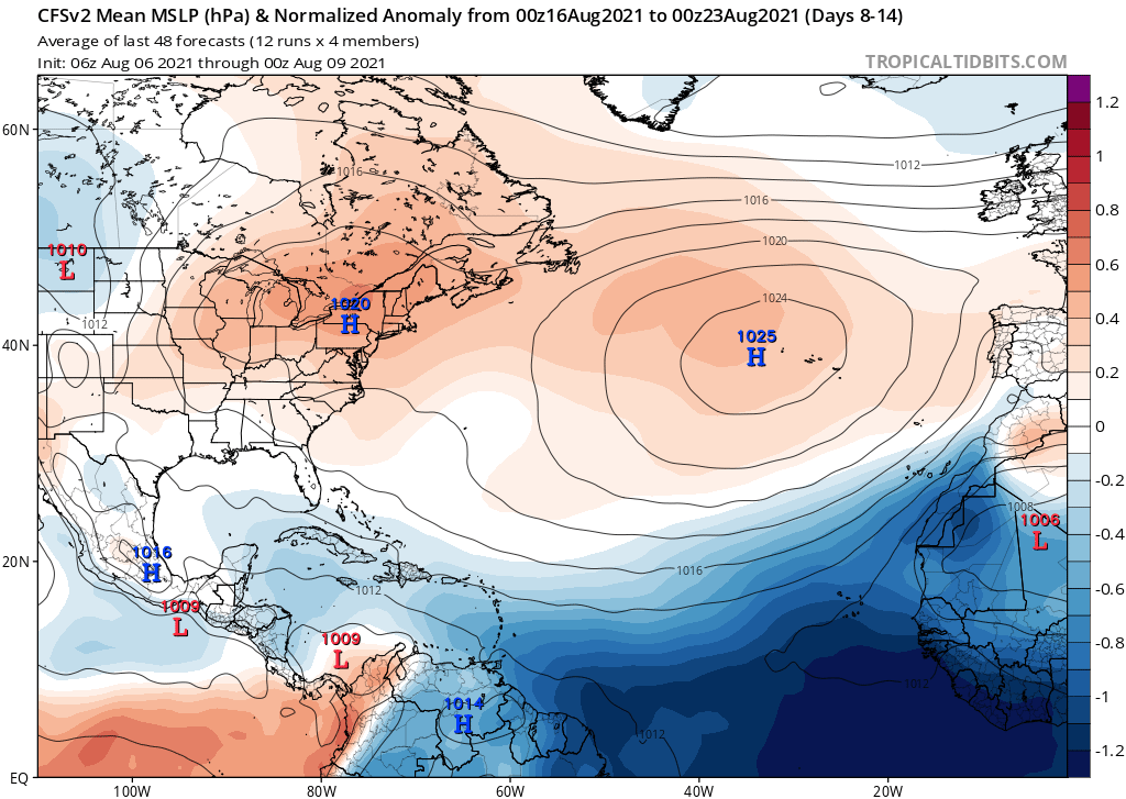
August 2021:
October 2021:
Moderator: S2k Moderators


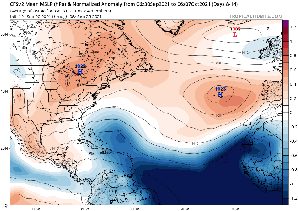
AlphaToOmega wrote:When you see the CFSv2 forecasting well-below average MSLP in the MDR, it is probably a sign of a tropical cyclone outbreak. Something similar occurred in late August of 2021; there was forecasted below-average MSLP in the MDR, and six storms developed that month. Six or more storms developing in October is not out of the realm of possibility.
August 2021:
https://i.postimg.cc/wxL73Lq1/cfs-avg-mslpa-Norm-Mean-atl-2.png
October 2021:
https://i.postimg.cc/nzxyYWkg/cfs-avg-mslpa-Norm-Mean-atl-2.png
Teban54 wrote:https://twitter.com/philklotzbach/status/1441157339218804736?s=19
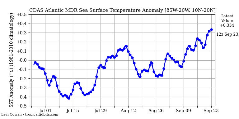
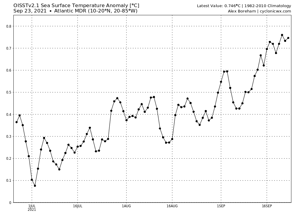
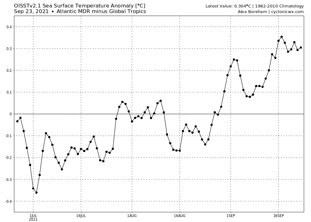
Wow, given the less than stellar MDR SST profile when the season first started (and the number of season cancel posts because of that), this is certainly not the kind of record I was expecting. The time frame is September 9-23, btw.
It's interesting that both 2005 and 2021 didn't feature any quality CV storms during this time period, which might contribute to 2021 making it to the second place since other years had more upwelling occur. Unlike 2005, 2021 finally saw a storm that makes use of the fuel: Sam.
IMO, this also means a better chance of waves surviving and entering the Caribbean during October. Wouldn't be surprised if we actually see developments in the MDR itself.
AlphaToOmega wrote:MDR development in October is not that abnormal. We saw MDR development in late October 2010 with Hurricane Tomas.
CRW looks even more favorable. This certainly isn't the SST profile of a season that shuts down early.Teban54 wrote: https://twitter.com/philklotzbach/status/1441157339218804736
Wow, given the less than stellar MDR SST profile when the season first started (and the number of season cancel posts because of that), this is certainly not the kind of record I was expecting. The time frame is September 9-23, btw.
It's interesting that both 2005 and 2021 didn't feature any quality CV storms during this time period, which might contribute to 2021 making it to the second place since other years had more upwelling occur. Unlike 2005, 2021 finally saw a storm that makes use of the fuel: Sam.
IMO, this also means a better chance of waves surviving and entering the Caribbean during October. Wouldn't be surprised if we actually see developments in the MDR itself.


WiscoWx02 wrote:It is honestly incredible that we are again approaching the end of the list. This was never supposed to happen again after 2005 and here we are. The even more incredible thing to think is that 20-30 years ago, Ana, Bill, Claudette, Danny, Julian, Kate, Mindy, Odette, Peter, Rose would never have been named because of the lack of good satellite imagery. To think we would probably only be at Fred right now if it were 1980


WiscoWx02 wrote:It is honestly incredible that we are again approaching the end of the list. This was never supposed to happen again after 2005 and here we are. The even more incredible thing to think is that 20-30 years ago, Ana, Bill, Claudette, Danny, Julian, Kate, Mindy, Odette, Peter, Rose would never have been named because of the lack of good satellite imagery. To think we would probably only be at Fred right now if it were 1980


Stormybajan wrote:WiscoWx02 wrote:It is honestly incredible that we are again approaching the end of the list. This was never supposed to happen again after 2005 and here we are. The even more incredible thing to think is that 20-30 years ago, Ana, Bill, Claudette, Danny, Julian, Kate, Mindy, Odette, Peter, Rose would never have been named because of the lack of good satellite imagery. To think we would probably only be at Fred right now if it were 1980
Running down the naming list is the easiest part, thats for sure. However to get close to 15 and 14 hurricanes with 7 MAJORS, im not expecting that again lets say...8 years from now.
Would be lying though if I ever imagined using up the entire naming list in BACK TO BACK seasons in a row thats astonishing.
AlphaToOmega wrote:Tropical Storm Teresa has formed in the Atlantic. Eight storms have formed this September (Larry, Mindy, Nicholas, Odette, Peter, Rose, Sam, and Teresa). Larry, Nicholas, and Sam have become hurricanes; and Larry was a major hurricane, and Sam is also likely to be a major hurricane. This shows how powerful climatology is for hurricane seasons.
Ubuntwo wrote:AlphaToOmega wrote:Tropical Storm Teresa has formed in the Atlantic. Eight storms have formed this September (Larry, Mindy, Nicholas, Odette, Peter, Rose, Sam, and Teresa). Larry, Nicholas, and Sam have become hurricanes; and Larry was a major hurricane, and Sam is also likely to be a major hurricane. This shows how powerful climatology is for hurricane seasons.
I thought 8+ named storms was unlikely this September, we are now poised to have 8-9. I stand corrected. Thankfully land areas have avoided major impacts from the many storms.
AlphaToOmega wrote:You can thank Henri for that. Henri, combined with the train of activity we saw and are seeing, made the NAO negative for September, thus sparing most (aside from Newfoundland) from major land impacts.
Hurricane Henri created a weakness in the Bermuda High. Tropical Storms Kate and Julian took advantage of that and recurved out to see. Hurricane Larry took advantage of that and spared the CONUS and Caribbean from land impacts by impacting Newfoundland. This flood of activity made the Bermuda High incredibly weak. Weakness persisted into mid-September, which allowed Tropical Storms Odette, Peter, and Rose to recurve out to sea. Hurricane Sam is a wild card right now; for the GFS indicates an out to sea storm, but the ECMWF and CMC indicate a landfalling storm.
Users browsing this forum: Kingarabian, SFLcane, SteveM and 131 guests


