Interestingly, 3 of my top 4 ENSO analogs for 2021 showed up as the #3, #4, and #5 best analogs based on 30 day SSTA on Tropical Tidbits.
Top 5 Analogs - Year: ACC
1974: 0.35
1976: 0.34
2011: 0.34
2008: 0.31
1999: 0.3
2021 Indicators: SST's / SAL / MSLP / Shear / Steering / Instability / Sat Images
Moderator: S2k Moderators
Forum rules

The posts in this forum are NOT official forecasts and should not be used as such. They are just the opinion of the poster and may or may not be backed by sound meteorological data. They are NOT endorsed by any professional institution or STORM2K. For official information, please refer to products from the National Hurricane Center and National Weather Service.
-
CyclonicFury

- Category 5

- Posts: 1974
- Age: 25
- Joined: Sun Jul 02, 2017 12:32 pm
- Location: NC
- Contact:
Re: 2021 Indicators: SST's / SAL / MSLP / Shear / Steering / Instability / Sat Images
3 likes
NCSU B.S. in Meteorology Class of 2021. Tropical weather blogger at http://www.cyclonicfury.com. My forecasts and thoughts are NOT official, for official forecasts please consult the National Hurricane Center.
-
Shell Mound
- Category 5
- Posts: 2434
- Age: 31
- Joined: Thu Sep 07, 2017 3:39 pm
- Location: St. Petersburg, FL → Scandinavia
Re: 2021 Indicators: SST's / SAL / MSLP / Shear / Steering / Instability / Sat Images
HurricaneEnzo wrote:Shell Mound wrote:CONUS Hurricane Strikes: 2016–20
Year.....Total...GoM.....EC
2016....2........1..........1
2017....3........3..........0
2018....2........1..........1
2019....2........1..........1
2020....6........5..........1
YYYY....15......11........4
CONUS Hurricane Strikes: CyclonicFury’s Analog Years (1996, 1999, 2008, 2011)
Year.....Total...GoM.....EC
1996....2........0..........2
1999....3........2..........1
2008....3........3..........0
2011....1........0..........1
YYYY....9........5..........4
If these analogs mean anything, maybe 2021 will feature more of a balance between GoM and EC hurricane landfalls than the past five seasons. We shall see. Based on historical data, the more pronounced Niña signature in the oceanic-atmospheric conditions (including +NAO via -ENSO/-PDO feedback), the stronger/farther northeast the Bermuda-Azores High, meaning hurricanes tend to make landfall farther north/east along the CONUS. Weakly Niña or cool neutral ENSO signature means less of a strongly -PDO/+NAO, hence storms making landfall farther south/west, e.g., in the GoM or on the Florida peninsula vs. the Carolinas/Mid-Atlantic. Stronger Niñas actually tend to suppress total NS due to outflow from the greater proportion of stronger hurricanes in the MDR. Bottom line: if the current trend toward a stronger global Niña signature persists through ASO, then we may see more of a hurricane threat to the East Coast north of peninsular Florida vs. the Gulf-centric activity we’ve tended to see over the past five seasons. After all, during strong(-er) Niñas storms tend to develop farther east in the MDR and become stronger, hence more opportunity to turn northward along the U.S. East Coast.
CycloneFurys analogs are not painting a good picture for my neck of the woods in ENC. 3 of those 4 years featured significant impacts from storms and some of NCs most notorious Hurricanes. 96' - Bertha and Fran, 99' - Floyd and Dennis(TS), 11' - Irene
ENC has also featured a landfalling Hurricane in each of the last 3 seasons. 18' -Florence 19' -Dorian 20' -Isaias. Matthew also caused massive flooding as it passed in 16. Coincidentally this time period reminds me of the mid-to-late 90s activity we saw here.
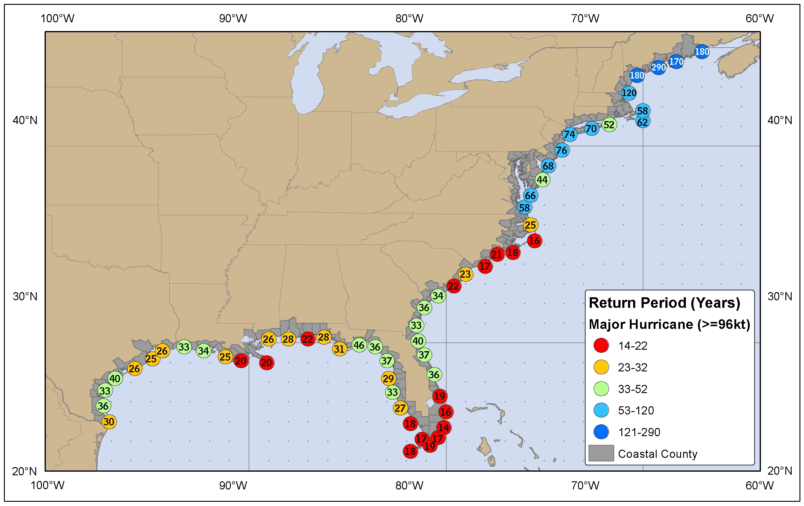
According to NOAA, the longest return rate for a MH impact in eastern NC is twenty-one years (thirty-four in SC). Fran (1996) is the most recent MH to make landfall in the Carolinas and the last MH impact in NC (Hugo ‘89 is the last MH impact in SC). Fran occurred twenty-four years ago, Hugo thirty-one. So NC at the very least is just about due for a major impact, or even a bit overdue. Certainly both NC/SC have seen a number of significant impacts from tropical storms and sub-major hurricanes recently, given epic flooding and widespread storm surge, so a major hurricane would be especially devastating in terms of wind-caused impacts. I think there is a better-than-average chance for the MH drought in NC to be finally broken this season. I also would advise South Florida to watch out for a late-season major impact from the south and west in October, given that double-dip Niñas often yield long-lasting seasons that extend well into November at times. But I definitely think the CV season will likely be much more intense than it was last season and that the Carolinas northward are likely to be in the crosshairs of at least one powerful long-tracker during peak season, ceteris paribus (all other factors being equal).
2 likes
CVW / MiamiensisWx / Shell Mound
The posts in this forum are NOT official forecasts and should not be used as such. They are just the opinion of the poster and may or may not be backed by sound meteorological data. They are NOT endorsed by any professional institution or STORM2K. For official information, please refer to products from the NHC and NWS.
-
tolakram
- Admin

- Posts: 19165
- Age: 60
- Joined: Sun Aug 27, 2006 8:23 pm
- Location: Florence, KY (name is Mark)
Re: 2021 Indicators: SST's / SAL / MSLP / Shear / Steering / Instability / Sat Images
Rather than prune this thread how about a reminder to stay on topic. This is the indicator thread and if you find yourself writing a book without any indicator discussion then you're in the wrong thread. Thanks. 
6 likes
M a r k
- - - - -
Join us in chat: Storm2K Chatroom Invite. Android and IOS apps also available.
The posts in this forum are NOT official forecasts and should not be used as such. Posts are NOT endorsed by any professional institution or STORM2K.org. For official information and forecasts, please refer to NHC and NWS products.

Re: 2021 Indicators: SST's / SAL / MSLP / Shear / Steering / Instability / Sat Images

1 likes
Personal Forecast Disclaimer:
The posts in this forum are NOT official forecast and should not be used as such. They are just the opinion of the poster and may or may not be backed by sound meteorological data. They are NOT endorsed by any professional institution or storm2k.org. For official information, please refer to the NHC and NWS products.
The posts in this forum are NOT official forecast and should not be used as such. They are just the opinion of the poster and may or may not be backed by sound meteorological data. They are NOT endorsed by any professional institution or storm2k.org. For official information, please refer to the NHC and NWS products.
-
cainjamin

- Tropical Storm

- Posts: 161
- Age: 33
- Joined: Mon Apr 17, 2017 1:38 pm
- Location: Nova Scotia, Canada
Re: 2021 Indicators: SST's / SAL / MSLP / Shear / Steering / Instability / Sat Images
https://twitter.com/BenNollWeather/status/1360682218453016581
Even more ominous signals unfortunately.
Even more ominous signals unfortunately.
0 likes
Noel '07, Kyle '08, Earl '10, Arthur '14, Dorian '19, Teddy '20, Lee '23
-
SFLcane

- S2K Supporter

- Posts: 9606
- Age: 46
- Joined: Sat Jun 05, 2010 1:44 pm
- Location: Lake Worth Florida
Re: 2021 Indicators: SST's / SAL / MSLP / Shear / Steering / Instability / Sat Images
cainjamin wrote:https://twitter.com/BenNollWeather/status/1360682218453016581
Even more ominous signals unfortunately.
It’s early but that’s Quite the signal in the Bahamas. Florida may not be so lucky this year but we shall see.
0 likes
-
InfernoFlameCat

- Category 5
- Posts: 1966
- Age: 21
- Joined: Mon Dec 14, 2020 10:52 am
- Location: Buford, GA
Re: 2021 Indicators: SST's / SAL / MSLP / Shear / Steering / Instability / Sat Images
CyclonicFury wrote:Interestingly, 3 of my top 4 ENSO analogs for 2021 showed up as the #3, #4, and #5 best analogs based on 30 day SSTA on Tropical Tidbits.
Top 5 Analogs - Year: ACC
1974: 0.35
1976: 0.34
2011: 0.34
2008: 0.31
1999: 0.3
Is this a coincidence that those years had VERY powerful severe storm seasons? I think not!!!
1 likes
I am by no means a professional. DO NOT look at my forecasts for official information or make decisions based on what I post.
Goal: to become a registered expert over tropical and subtropical cyclones.
Goal: to become a registered expert over tropical and subtropical cyclones.
-
SconnieCane
- Category 4

- Posts: 913
- Joined: Thu Aug 02, 2018 5:29 pm
- Location: Madison, WI
Re: 2021 Indicators: SST's / SAL / MSLP / Shear / Steering / Instability / Sat Images
InfernoFlameCat wrote:CyclonicFury wrote:Interestingly, 3 of my top 4 ENSO analogs for 2021 showed up as the #3, #4, and #5 best analogs based on 30 day SSTA on Tropical Tidbits.
Top 5 Analogs - Year: ACC
1974: 0.35
1976: 0.34
2011: 0.34
2008: 0.31
1999: 0.3
Is this a coincidence that those years had VERY powerful severe storm seasons? I think not!!!
We'll see. Apparently a lot of the climate model runs at the beginning of February were very lackluster for the spring, kind of flying in the face of all the other indicators. Of course they could easily be wrong at this range, but it's a bit eyebrow-raising that they were in such unanimous agreement.
https://stormtrack.org/community/thread ... ost-370406
1 likes
-
CyclonicFury
- Category 5
- Posts: 1974
- Age: 25
- Joined: Sun Jul 02, 2017 12:32 pm
- Location: NC
- Contact:
Re: 2021 Indicators: SST's / SAL / MSLP / Shear / Steering / Instability / Sat Images
Even the Euro looks relatively wet in the MDR and Africa for August, not a signal you want to see
https://twitter.com/CyclonicFury/status/1361366540097052672
https://twitter.com/CyclonicFury/status/1361366540097052672
5 likes
NCSU B.S. in Meteorology Class of 2021. Tropical weather blogger at http://www.cyclonicfury.com. My forecasts and thoughts are NOT official, for official forecasts please consult the National Hurricane Center.
-
Shell Mound
- Category 5
- Posts: 2434
- Age: 31
- Joined: Thu Sep 07, 2017 3:39 pm
- Location: St. Petersburg, FL → Scandinavia
Re: 2021 Indicators: SST's / SAL / MSLP / Shear / Steering / Instability / Sat Images
CyclonicFury wrote:Even the Euro looks relatively wet in the MDR and Africa for August, not a signal you want to see
https://twitter.com/CyclonicFury/status/1361366540097052672
As it did last year, it also seems to be showing a strong WAR that may either keep activity OTS or shunted toward the Caribbean/BoC/S GoM.
0 likes
CVW / MiamiensisWx / Shell Mound
The posts in this forum are NOT official forecasts and should not be used as such. They are just the opinion of the poster and may or may not be backed by sound meteorological data. They are NOT endorsed by any professional institution or STORM2K. For official information, please refer to products from the NHC and NWS.
-
Category5Kaiju

- Category 5
- Posts: 3355
- Age: 22
- Joined: Thu Dec 24, 2020 12:45 pm
- Location: Seattle
Re: 2021 Indicators: SST's / SAL / MSLP / Shear / Steering / Instability / Sat Images
Shell Mound wrote:CyclonicFury wrote:Even the Euro looks relatively wet in the MDR and Africa for August, not a signal you want to see
https://twitter.com/CyclonicFury/status/1361366540097052672
As it did last year, it also seems to be showing a strong WAR that may either keep activity OTS or shunted toward the Caribbean/BoC/S GoM.
I'm also personally curious to see how much the Sahara dust will be a factor as well as whether we'll be seeing that "surprise" wind shear that unexpected weakened storms like Delta
0 likes
Unless explicitly stated, all information covered in my posts is based on my opinions and observations. Please refer to a professional meteorologist or an accredited weather research agency otherwise, especially if serious decisions must be made in the event of a potentially life-threatening tropical storm or hurricane.
-
weeniepatrol

- Category 3

- Posts: 857
- Joined: Sat Aug 22, 2020 5:30 pm
- Location: WA State

-
cycloneye

- Admin
- Posts: 139059
- Age: 67
- Joined: Thu Oct 10, 2002 10:54 am
- Location: San Juan, Puerto Rico
Re: 2021 Indicators: SST's / SAL / MSLP / Shear / Steering / Instability / Sat Images
5 likes
Visit the Caribbean-Central America Weather Thread where you can find at first post web cams,radars
and observations from Caribbean basin members Click Here
and observations from Caribbean basin members Click Here
-
Category5Kaiju
- Category 5
- Posts: 3355
- Age: 22
- Joined: Thu Dec 24, 2020 12:45 pm
- Location: Seattle
Re: 2021 Indicators: SST's / SAL / MSLP / Shear / Steering / Instability / Sat Images
https://twitter.com/cyclonicwx/status/1 ... 2940936193
According to Alex Boreham, for some reason the MDR has really cooled off. I am inclined to think that this is temporary and that a major SAL surge may be to blame, although I'm not 100% sure and somebody else may have more insight into this.
According to Alex Boreham, for some reason the MDR has really cooled off. I am inclined to think that this is temporary and that a major SAL surge may be to blame, although I'm not 100% sure and somebody else may have more insight into this.
1 likes
Unless explicitly stated, all information covered in my posts is based on my opinions and observations. Please refer to a professional meteorologist or an accredited weather research agency otherwise, especially if serious decisions must be made in the event of a potentially life-threatening tropical storm or hurricane.
-
NotSparta

- Professional-Met

- Posts: 1647
- Age: 22
- Joined: Fri Aug 18, 2017 8:24 am
- Location: Naples, FL
- Contact:
Re: 2021 Indicators: SST's / SAL / MSLP / Shear / Steering / Instability / Sat Images
Category5Kaiju wrote:https://twitter.com/cyclonicwx/status/1363557282940936193
According to Alex Boreham, for some reason the MDR has really cooled off. I am inclined to think that this is temporary and that a major SAL surge may be to blame, although I'm not 100% sure and somebody else may have more insight into this.
That's me, appears to be a surge of trade winds coupled with a SAL surge. So, part of it is legitimate but it could be partly due to the SAL surge as you mentioned. Hard to count on this being something causing an inactive season, seems to be a springtime red herring that has repeated itself around Feb-Apr or so since 2017. Hard to tell what we'll have come ASO
8 likes
This post was probably an opinion of mine, and in no way is official. Please refer to http://www.hurricanes.gov for official tropical analysis and advisories.
My website, with lots of tropical wx graphics, including satellite and recon: http://cyclonicwx.com
My website, with lots of tropical wx graphics, including satellite and recon: http://cyclonicwx.com
-
cycloneye
- Admin
- Posts: 139059
- Age: 67
- Joined: Thu Oct 10, 2002 10:54 am
- Location: San Juan, Puerto Rico
Re: 2021 Indicators: SST's / SAL / MSLP / Shear / Steering / Instability / Sat Images
3 likes
Visit the Caribbean-Central America Weather Thread where you can find at first post web cams,radars
and observations from Caribbean basin members Click Here
and observations from Caribbean basin members Click Here
-
Category5Kaiju
- Category 5
- Posts: 3355
- Age: 22
- Joined: Thu Dec 24, 2020 12:45 pm
- Location: Seattle
Re: 2021 Indicators: SST's / SAL / MSLP / Shear / Steering / Instability / Sat Images
Oh yeah btw Weather Channel recently released a post about the names for this year's Atlantic season:
https://weather.com/storms/hurricane/ne ... ason-names
Something I have noticed is they never mention what would happen if we somehow passed "Wanda" this season; while there's another separate thread on this topic and I'll avoid diving into detail here, I think there's real doubt about continued Greek alphabet use in the future
0 likes
Unless explicitly stated, all information covered in my posts is based on my opinions and observations. Please refer to a professional meteorologist or an accredited weather research agency otherwise, especially if serious decisions must be made in the event of a potentially life-threatening tropical storm or hurricane.
-
weathaguyry

- Category 5
- Posts: 1272
- Age: 20
- Joined: Wed Jun 15, 2016 5:16 am
- Location: Long Island, NY
Re: 2021 Indicators: SST's / SAL / MSLP / Shear / Steering / Instability / Sat Images
Fascinating to see the indicators so bullish yet again this season. You'd think that with the positive AMO phase starting all the way back in 1995 that we wouldn't be seeing indicators like this after a season like 2020. However, I do have faith that maybe indicators can back off somewhat to at least not produce a season as horrendous and devastating as last year. After all, a record season can spoil us hurricane watchers rotten, just look at the 2006 numbers poll 
7 likes
My posts are only my opinions and NOT official forecasts. For official forecasts, consult the National Hurricane Center or the National Weather Service.
Irene 11', Sandy 12', Fay 20’, Isaias 20’, Elsa 21’, Henri 21’, Ida 21’
Irene 11', Sandy 12', Fay 20’, Isaias 20’, Elsa 21’, Henri 21’, Ida 21’
Re: 2021 Indicators: SST's / SAL / MSLP / Shear / Steering / Instability / Sat Images
2006 was an epic burn for seasonal forecasters. It does seem like we're headed for another active year in 21.. with the limited visibility we have at this point. I'm certainly enjoying the off season..
0 likes