2021 Indicators: SST's / SAL / MSLP / Shear / Steering / Instability / Sat Images

This is the general tropical discussion area. Anyone can take their shot at predicting a storms path.

Moderator: S2k Moderators

Forum rules

The posts in this forum are NOT official forecasts and should not be used as such. They are just the opinion of the poster and may or may not be backed by sound meteorological data. They are NOT endorsed by any professional institution or STORM2K. For official information, please refer to products from the National Hurricane Center and National Weather Service.

Help Support Storm2K
Message
Author
User avatar
Steve
S2K Supporter
S2K Supporter
Posts: 8606
Joined: Sat Apr 05, 2003 11:41 pm
Location: Not a state-caster

Re: 2021 Indicators: SST's / SAL / MSLP / Shear / Steering / Instability / Sat Images

#3321 Postby Steve » Wed Sep 15, 2021 9:47 am

WiscoWx02 wrote:
Weather Dude wrote:
AlphaToOmega wrote:Right now, there is sinking air in the Atlantic; there has been sinking air in the Atlantic for a week or so at this point. The reasons there has been activity are the African Standing Wave and climatology.

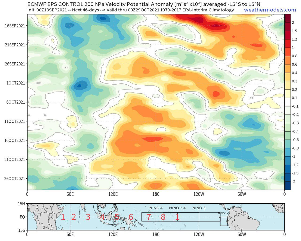
The ECMWF shows an African Standing Wave all the way through October. A weak CCKW should create a burst of activity at the end of September. A strong CCKW should create another burst of activity in the middle of October. Climatologically, October is not as favorable as September, but it still counts as part of the peak of hurricane season; and the month could still produce give or take 5-6 storms given these factors.

Should this verify, it would virtually guarantee that 2021 will rival 2020 and 2005 in terms of activity. The thing that will likely determine if 2021 breaks the records of 2020 and 2005 is how active November and December are.

https://i.postimg.cc/JnNpbq5S/241222563-1496350387385525-5844399051510248176-n.png

2021 almost certainly will not get anywhere close to 2005 or 2020 levels of activity. Just because a favorable phase is coming up does not guarantee record levels of activity.


I agree, we will never see what we saw last year or in 2005 again simply because no two hurricane seasons are the same. We might see one major hurricane in October but probably nothing more than that. We will probably have some weaker storms as well but they won't come close to what we saw last year. I definitely think the coasts should watch out come October given the expected pattern though. Not as bullish on October as I was before, but still think it will be an active month.


That's not a bet I'd ever make much less with an on-coming La NIna. If you were to say maybe the US only has to deal with 1 major in October or something, I could see that. But not calling for simply one major in the entire basin - particularly with the back weighted last couple of seasons. JMO
9 likes   

User avatar
Category5Kaiju
Category 5
Category 5
Posts: 3356
Age: 22
Joined: Thu Dec 24, 2020 12:45 pm
Location: Seattle

Re: 2021 Indicators: SST's / SAL / MSLP / Shear / Steering / Instability / Sat Images

#3322 Postby Category5Kaiju » Wed Sep 15, 2021 10:13 am

Steve wrote:
WiscoWx02 wrote:
Weather Dude wrote:2021 almost certainly will not get anywhere close to 2005 or 2020 levels of activity. Just because a favorable phase is coming up does not guarantee record levels of activity.


I agree, we will never see what we saw last year or in 2005 again simply because no two hurricane seasons are the same. We might see one major hurricane in October but probably nothing more than that. We will probably have some weaker storms as well but they won't come close to what we saw last year. I definitely think the coasts should watch out come October given the expected pattern though. Not as bullish on October as I was before, but still think it will be an active month.


That's not a bet I'd ever make much less with an on-coming La NIna. If you were to say maybe the US only has to deal with 1 major in October or something, I could see that. But not calling for simply one major in the entire basin - particularly with the back weighted last couple of seasons. JMO


Yeah especially as we saw with seasons like 2016 (Matthew, Nicole, and Otto), 2017 (Ophelia and most likely Nate if it was slower), and 2020 (Delta, Epsilon, Zeta, Eta, and Iota), recent La Nina years have tended to save at least two major hurricanes for October and beyond, and I personally find it hard to think why 2021 would deviate from this pattern all that much. I feel like at least 2 MHs for October and beyond is a reasonable guess, just one in the entire basin in the entire month feels a bit too bearish.
5 likes   
Unless explicitly stated, all information covered in my posts is based on my opinions and observations. Please refer to a professional meteorologist or an accredited weather research agency otherwise, especially if serious decisions must be made in the event of a potentially life-threatening tropical storm or hurricane.

User avatar
Teban54
Category 5
Category 5
Posts: 1958
Joined: Sat May 19, 2018 1:19 pm

Re: 2021 Indicators: SST's / SAL / MSLP / Shear / Steering / Instability / Sat Images

#3323 Postby Teban54 » Wed Sep 15, 2021 11:07 am

 https://twitter.com/WxTca/status/1438153477075656705


Looks like all the early season complaints about below-average MDR SSTs have busted. Even if the CV season ends up disappointing to some, SSTs won't be the cause.
1 likes   

User avatar
Woofde
Category 1
Category 1
Posts: 267
Joined: Tue Jul 06, 2021 11:33 am

Re: 2021 Indicators: SST's / SAL / MSLP / Shear / Steering / Instability / Sat Images

#3324 Postby Woofde » Wed Sep 15, 2021 11:12 am

I think we are going to see an anomalously active Late season this year.

The biggest factor that's gone largely under the radar is the Atlantic Nino. It has been hard at work developing and distributing very warm water(See the 90 day SST gif). Almost the entire Atlantic is above average in part because of this. There's still lots of heat and warmth, including deep below the surface, that will act like a battery for the tropics to draw from as we enter October and probably even November.

With La Nina too, It's quite a combo. The Atlantic Nino provides the heat and warmth, while the La Nina brings favorable upper atmospheric conditions. ImageImageImage
9 likes   

User avatar
Category5Kaiju
Category 5
Category 5
Posts: 3356
Age: 22
Joined: Thu Dec 24, 2020 12:45 pm
Location: Seattle

Re: 2021 Indicators: SST's / SAL / MSLP / Shear / Steering / Instability / Sat Images

#3325 Postby Category5Kaiju » Wed Sep 15, 2021 12:00 pm

Teban54 wrote:https://twitter.com/WxTca/status/1438153477075656705?s=19

Looks like all the early season complaints about below-average MDR SSTs have busted. Even if the CV season ends up disappointing to some, SSTs won't be the cause.


Not just “busted,” I think “BUSTED” is a better expression.
0 likes   
Unless explicitly stated, all information covered in my posts is based on my opinions and observations. Please refer to a professional meteorologist or an accredited weather research agency otherwise, especially if serious decisions must be made in the event of a potentially life-threatening tropical storm or hurricane.

psyclone
S2K Supporter
S2K Supporter
Posts: 4487
Joined: Wed Aug 24, 2005 9:04 pm
Location: palm harbor fl

Re: 2021 Indicators: SST's / SAL / MSLP / Shear / Steering / Instability / Sat Images

#3326 Postby psyclone » Wed Sep 15, 2021 12:34 pm

I think of the first half of september as the absolute season peak and this year it seemed underwhelming.
4 likes   

Nuno
Category 2
Category 2
Posts: 529
Joined: Fri Aug 30, 2019 8:35 am
Location: Coral Gables, FL

Re: 2021 Indicators: SST's / SAL / MSLP / Shear / Steering / Instability / Sat Images

#3327 Postby Nuno » Wed Sep 15, 2021 12:42 pm

psyclone wrote:I think of the first half of september as the absolute season peak and this year it seemed underwhelming.


I mean, we just came off a Category 4 making landfall a couple days before September and an unusually strong cyclone passing through Newfoundland after people finally got their CV storm.

Can't please everyone I guess :roll:
7 likes   
Andrew (1992), Irene (1999), Frances (2004), Katrina (2005), Wilma (2005), Fay (2008), Irma (2017), Eta (2020), Ian (2022)

User avatar
Category5Kaiju
Category 5
Category 5
Posts: 3356
Age: 22
Joined: Thu Dec 24, 2020 12:45 pm
Location: Seattle

Re: 2021 Indicators: SST's / SAL / MSLP / Shear / Steering / Instability / Sat Images

#3328 Postby Category5Kaiju » Wed Sep 15, 2021 12:46 pm

Nuno wrote:
psyclone wrote:I think of the first half of september as the absolute season peak and this year it seemed underwhelming.


I mean, we just came off a Category 4 making landfall a couple days before September and an unusually strong cyclone passing through Newfoundland after people finally got their CV storm.

Can't please everyone I guess :roll:


To please everyone, you need 6 simultaneous CV Category 5 hurricanes hit the CONUS in late August and early September. Oh yeah and any other less strong storm would still reach major hurricane strength. :D
8 likes   
Unless explicitly stated, all information covered in my posts is based on my opinions and observations. Please refer to a professional meteorologist or an accredited weather research agency otherwise, especially if serious decisions must be made in the event of a potentially life-threatening tropical storm or hurricane.

User avatar
Category5Kaiju
Category 5
Category 5
Posts: 3356
Age: 22
Joined: Thu Dec 24, 2020 12:45 pm
Location: Seattle

Re: 2021 Indicators: SST's / SAL / MSLP / Shear / Steering / Instability / Sat Images

#3329 Postby Category5Kaiju » Wed Sep 15, 2021 12:47 pm

psyclone wrote:I think of the first half of september as the absolute season peak and this year it seemed underwhelming.


I think the second half of September may make up for that, as models are becoming more interested in 95L's long term prospects once again.
1 likes   
Unless explicitly stated, all information covered in my posts is based on my opinions and observations. Please refer to a professional meteorologist or an accredited weather research agency otherwise, especially if serious decisions must be made in the event of a potentially life-threatening tropical storm or hurricane.

psyclone
S2K Supporter
S2K Supporter
Posts: 4487
Joined: Wed Aug 24, 2005 9:04 pm
Location: palm harbor fl

Re: 2021 Indicators: SST's / SAL / MSLP / Shear / Steering / Instability / Sat Images

#3330 Postby psyclone » Wed Sep 15, 2021 12:52 pm

Nuno wrote:
psyclone wrote:I think of the first half of september as the absolute season peak and this year it seemed underwhelming.


I mean, we just came off a Category 4 making landfall a couple days before September and an unusually strong cyclone passing through Newfoundland after people finally got their CV storm.

Can't please everyone I guess :roll:


I expected this response and love the eyeroll...but the comment stands. The lack of absolute peak season drama was not what i expected for the apex. Still the most dangerous part of the season for my neck of the woods is just starting and considering how back loaded seasons have been...I'm expecting more drama.
1 likes   

Nuno
Category 2
Category 2
Posts: 529
Joined: Fri Aug 30, 2019 8:35 am
Location: Coral Gables, FL

Re: 2021 Indicators: SST's / SAL / MSLP / Shear / Steering / Instability / Sat Images

#3331 Postby Nuno » Wed Sep 15, 2021 1:08 pm

psyclone wrote:
Nuno wrote:
psyclone wrote:I think of the first half of september as the absolute season peak and this year it seemed underwhelming.


I mean, we just came off a Category 4 making landfall a couple days before September and an unusually strong cyclone passing through Newfoundland after people finally got their CV storm.

Can't please everyone I guess :roll:


I expected this response and love the eyeroll...but the comment stands. The lack of absolute peak season drama was not what i expected for the apex. Still the most dangerous part of the season for my neck of the woods is just starting and considering how back loaded seasons have been...I'm expecting more drama.


What constitutes "peak season drama"? Did we just not have several landfalling storms of varying strength and in different parts of the basin? I'm just trying to understand this point of view lol
4 likes   
Andrew (1992), Irene (1999), Frances (2004), Katrina (2005), Wilma (2005), Fay (2008), Irma (2017), Eta (2020), Ian (2022)

psyclone
S2K Supporter
S2K Supporter
Posts: 4487
Joined: Wed Aug 24, 2005 9:04 pm
Location: palm harbor fl

Re: 2021 Indicators: SST's / SAL / MSLP / Shear / Steering / Instability / Sat Images

#3332 Postby psyclone » Wed Sep 15, 2021 1:15 pm

Nuno wrote:
psyclone wrote:
Nuno wrote:
I mean, we just came off a Category 4 making landfall a couple days before September and an unusually strong cyclone passing through Newfoundland after people finally got their CV storm.

Can't please everyone I guess :roll:


I expected this response and love the eyeroll...but the comment stands. The lack of absolute peak season drama was not what i expected for the apex. Still the most dangerous part of the season for my neck of the woods is just starting and considering how back loaded seasons have been...I'm expecting more drama.


What constitutes "peak season drama"? Did we just not have several landfalling storms of varying strength and in different parts of the basin? I'm just trying to understand this point of view lol


A multi night mega pucker long track terror. A Dorian type major that maybe struggles for awhile before going nutz. The bar is high for absolute peak season..it seemed we came up a bit short in that regard. Not a complaint either...just an observation covering a short 2 week timeframe that happens to encompass the summit of climo mountain.
0 likes   

AlphaToOmega
Category 5
Category 5
Posts: 1448
Joined: Sat Jun 26, 2021 10:51 am
Location: Somewhere in Massachusetts

Re: 2021 Indicators: SST's / SAL / MSLP / Shear / Steering / Instability / Sat Images

#3333 Postby AlphaToOmega » Wed Sep 15, 2021 4:50 pm

The ECENS ensembles show a possible tropical wave exiting Africa next week. Invest 95L and 96L are nearly guaranteed to develop, and the AoI in the MDR also looks good for development. Should all of the beforementioned systems become tropical storms, 2021 would reach Rose by September. Should that next wave develop, the season would reach Sam by September, putting the season ahead of 2005 and 2011.

Because the ECENS ensembles show rising air across the entire Atlantic basin through October, the season could see major hurricanes throughout October.

It is too early to make a determination about November, but it is likely that at least one storm forms in November. Looking at every cool-neutral, weak La Nina, or moderate La Nina year since 2001, there has been activity in November:

2001: Noel and Olga
2005: Gamma, Delta, and Epsilon
2008: Paloma
2011: Sean
2016: Otto
2017: Rina
2020: Eta, Theta, and Iota

Main takeaway:
Climatology is less favorable in October than it is in September, but October is still within the peak of hurricane season, and forecasted rising air patterns will likely yield threats to everyone in hurricane-prone areas.
5 likes   

User avatar
Hammy
Category 5
Category 5
Posts: 5594
Age: 40
Joined: Fri May 25, 2012 5:25 pm
Contact:

Re: 2021 Indicators: SST's / SAL / MSLP / Shear / Steering / Instability / Sat Images

#3334 Postby Hammy » Thu Sep 16, 2021 12:17 am

Something worth noting, years that had an active August followed by a generally less active September tended to have a lot occur during October/November.

Some examples since 1980:

1985 had 3/3/1, 3/1/1, and 3/2/1 during October/November, one of which was Kate
1990 had 6/2/1, 2/1/0, and 4/4/0 during October
1995 had 7/4/2, 2/2/1, and 5/3/2 during October (Opal is counted in October, where all but 12 hours of its existence occurred)
1996 had 4/3/2, 2/2/2 in September, and 3/2/1 after
1999 had 4/3/2, 3/2/2, and then October/November was 4/3/1 (or 4/3/2 if Irene was a Cat 3)
2012 had 8/5/0, 3/2/1, and 4/2/1 in October, of course one of which was Sandy

Even quiet year like 1994 or 2014, serve good examples: 1994 had 2/1/0 during August and only two weak tropical storms in September, but November saw two hurricanes--one of which was close to (or at) major, and 2014 had two hurricanes in August, one tropical storm and major hurricane in September (and nothing after the 15th), and October had 3/2/1, which of course the major was Gonzalo.
6 likes   
The above post is not official and should not be used as such. It is the opinion of the poster and may or may not be backed by sound meteorological data. It is not endorsed by any professional institution or storm2k.org. For official information, please refer to the NHC and NWS products.

AxaltaRacing24
Category 5
Category 5
Posts: 1709
Age: 23
Joined: Wed Jul 27, 2016 11:14 am
Location: Jupiter, FL

Re: 2021 Indicators: SST's / SAL / MSLP / Shear / Steering / Instability / Sat Images

#3335 Postby AxaltaRacing24 » Thu Sep 16, 2021 2:40 am

psyclone wrote:
Nuno wrote:
psyclone wrote:
I expected this response and love the eyeroll...but the comment stands. The lack of absolute peak season drama was not what i expected for the apex. Still the most dangerous part of the season for my neck of the woods is just starting and considering how back loaded seasons have been...I'm expecting more drama.


What constitutes "peak season drama"? Did we just not have several landfalling storms of varying strength and in different parts of the basin? I'm just trying to understand this point of view lol


A multi night mega pucker long track terror. A Dorian type major that maybe struggles for awhile before going nutz. The bar is high for absolute peak season..it seemed we came up a bit short in that regard. Not a complaint either...just an observation covering a short 2 week timeframe that happens to encompass the summit of climo mountain.

To be honest, your bar for peak season should NEVER be a once in a generation storm like Dorian or Irma. Those are incredibly rare and were both historic.
5 likes   

User avatar
kevin
Category 5
Category 5
Posts: 1768
Age: 25
Joined: Wed Aug 28, 2019 4:35 am

Re: 2021 Indicators: SST's / SAL / MSLP / Shear / Steering / Instability / Sat Images

#3336 Postby kevin » Thu Sep 16, 2021 2:56 am

Now that we're talking about October as well, here's an overview of the 24 strongest Atlantic hurricanes (the wikipedia table) by their formation month.

July = 1
August = 6
September = 10
October = 6
November = 1

So while September is indeed the 'peak', October is still a very active months in terms of the most extreme storms, just as active as August. Besides Wilma, the other 5 storms on this list that formed in October are Hattie, Mitch, Michael, 1924 Cuba and 1932 Cuba.
0 likes   

User avatar
Category5Kaiju
Category 5
Category 5
Posts: 3356
Age: 22
Joined: Thu Dec 24, 2020 12:45 pm
Location: Seattle

Re: 2021 Indicators: SST's / SAL / MSLP / Shear / Steering / Instability / Sat Images

#3337 Postby Category5Kaiju » Thu Sep 16, 2021 5:50 am

kevin wrote:Now that we're talking about October as well, here's an overview of the 24 strongest Atlantic hurricanes (the wikipedia table) by their formation month.

July = 1
August = 6
September = 10
October = 6
November = 1

So while September is indeed the 'peak', October is still a very active months in terms of the most extreme storms, just as active as August. Besides Wilma, the other 5 storms on this list that formed in October are Hattie, Mitch, Michael, 1924 Cuba and 1932 Cuba.


Interestingly, if this year experiences a storm like the 1932 Cuba hurricane, our ACE would jump by a lot.
1 likes   
Unless explicitly stated, all information covered in my posts is based on my opinions and observations. Please refer to a professional meteorologist or an accredited weather research agency otherwise, especially if serious decisions must be made in the event of a potentially life-threatening tropical storm or hurricane.

User avatar
Ubuntwo
Category 5
Category 5
Posts: 1089
Age: 30
Joined: Thu Oct 05, 2017 10:41 pm

Re: 2021 Indicators: SST's / SAL / MSLP / Shear / Steering / Instability / Sat Images

#3338 Postby Ubuntwo » Thu Sep 16, 2021 8:37 am

Unfavorable look for late September, though a kelvin wave could pass through the basin near the end of the month.
Image

MJO will come back into phase ~mid October.
0 likes   
Kendall -> SLO -> PBC

Memorable Storms: Katrina (for its Florida landfall...) Wilma Matthew Irma

User avatar
aspen
Category 5
Category 5
Posts: 8057
Joined: Sat Oct 12, 2019 7:10 pm
Location: Connecticut, USA

Re: 2021 Indicators: SST's / SAL / MSLP / Shear / Steering / Instability / Sat Images

#3339 Postby aspen » Thu Sep 16, 2021 10:13 am

If none of the three AOIs currently develop, the unfavorable MJO phase will likely halt development for weeks, and September will have had just 3 NS — lower than every other season of the current active stretch. Sept 2021 would be the weakest since 2016 despite Larry; 2017 had multiple long-trackers while 2018, 2019, and 2020 had other significant storms like Helene, Leslie, Humberto, Jerry, Lorenzo, Paulette, and Sally before or after their highest ACE long-tracker. Mindy was brief and Nicholas, while a hurricane landfall, is a far cry from the other storms I mentioned in both intensity and duration.

If no additional storms form, this would raise several questions: what killed September’s momentum despite climo peak coinciding with a developing Nina and an under-performing Pacific? Could we see a double-peak season like 2016 where both peaks are well before/after the normal peak in mid-September? And does this signal what the 2022 season could be like?
3 likes   
Irene '11 Sandy '12 Hermine '16 5/15/2018 Derecho Fay '20 Isaias '20 Elsa '21 Henri '21 Ida '21

I am only a meteorology enthusiast who knows a decent amount about tropical cyclones. Look to the professional mets, the NHC, or your local weather office for the best information.

tolakram
Admin
Admin
Posts: 19165
Age: 60
Joined: Sun Aug 27, 2006 8:23 pm
Location: Florence, KY (name is Mark)

Re: 2021 Indicators: SST's / SAL / MSLP / Shear / Steering / Instability / Sat Images

#3340 Postby tolakram » Thu Sep 16, 2021 10:26 am

It was noted by someone, a tweet maybe, that the jet stream was anomalously far north. I wonder if this actually sets up poorer conditions than expected, even though nina is present. The exciting thing is that we only learn when the unexpected happens, so like a 2013, now we might know what else to look for. Or not. :D
1 likes   
M a r k
- - - - -
Join us in chat: Storm2K Chatroom Invite. Android and IOS apps also available.

The posts in this forum are NOT official forecasts and should not be used as such. Posts are NOT endorsed by any professional institution or STORM2K.org. For official information and forecasts, please refer to NHC and NWS products.


Return to “Talkin' Tropics”

Who is online

Users browsing this forum: Beef Stew, Chris90, JaviT, NotSparta, pepecool20, zzzh and 185 guests