2021 Indicators: SST's / SAL / MSLP / Shear / Steering / Instability / Sat Images

This is the general tropical discussion area. Anyone can take their shot at predicting a storms path.

Moderator: S2k Moderators

Forum rules

The posts in this forum are NOT official forecasts and should not be used as such. They are just the opinion of the poster and may or may not be backed by sound meteorological data. They are NOT endorsed by any professional institution or STORM2K. For official information, please refer to products from the National Hurricane Center and National Weather Service.

Help Support Storm2K
Message
Author
User avatar
cycloneye
Admin
Admin
Posts: 139080
Age: 67
Joined: Thu Oct 10, 2002 10:54 am
Location: San Juan, Puerto Rico

2021 Indicators: SST's / SAL / MSLP / Shear / Steering / Instability / Sat Images: IMME shows very favorable signal

#261 Postby cycloneye » Wed Apr 21, 2021 7:27 am

SFLcane wrote:
cycloneye wrote:Adrian, I posted the Webb twit already
6 minutes before yours so will deleite it.


Hey! :mad:

Joking no problem my friend. Should be another crazy year


Yeah :crazyeyes:
0 likes   
Visit the Caribbean-Central America Weather Thread where you can find at first post web cams,radars
and observations from Caribbean basin members Click Here

tolakram
Admin
Admin
Posts: 19165
Age: 60
Joined: Sun Aug 27, 2006 8:23 pm
Location: Florence, KY (name is Mark)

Re: 2021 Indicators: SST's / SAL / MSLP / Shear / Steering / Instability / Sat Images: IMME shows very favorable signal

#262 Postby tolakram » Wed Apr 21, 2021 9:05 am

Web twit? :lol: I didn't say it!
3 likes   
M a r k
- - - - -
Join us in chat: Storm2K Chatroom Invite. Android and IOS apps also available.

The posts in this forum are NOT official forecasts and should not be used as such. Posts are NOT endorsed by any professional institution or STORM2K.org. For official information and forecasts, please refer to NHC and NWS products.

User avatar
cycloneye
Admin
Admin
Posts: 139080
Age: 67
Joined: Thu Oct 10, 2002 10:54 am
Location: San Juan, Puerto Rico

Re: 2021 Indicators: SST's / SAL / MSLP / Shear / Steering / Instability / Sat Images: IMME shows very favorable signal

#263 Postby cycloneye » Wed Apr 21, 2021 9:25 am

1 likes   
Visit the Caribbean-Central America Weather Thread where you can find at first post web cams,radars
and observations from Caribbean basin members Click Here

User avatar
Category5Kaiju
Category 5
Category 5
Posts: 3357
Age: 22
Joined: Thu Dec 24, 2020 12:45 pm
Location: Seattle

Re: 2021 Indicators: SST's / SAL / MSLP / Shear / Steering / Instability / Sat Images: IMME shows very favorable signal

#264 Postby Category5Kaiju » Wed Apr 21, 2021 9:38 am

The thermodynamics with the SST anomalies as well as the predicted strong WAM sure point toward an active Atlantic; I wonder why some of these models make the Atlantic dry though. That is really perplexing imho
0 likes   
Unless explicitly stated, all information covered in my posts is based on my opinions and observations. Please refer to a professional meteorologist or an accredited weather research agency otherwise, especially if serious decisions must be made in the event of a potentially life-threatening tropical storm or hurricane.

jconsor
Professional-Met
Professional-Met
Posts: 532
Joined: Mon Jun 30, 2008 9:31 pm
Location: Jerusalem, Israel
Contact:

Re: 2021 Indicators: SST's / SAL / MSLP / Shear / Steering / Instability / Sat Images: IMME shows very favorable signal

#265 Postby jconsor » Wed Apr 21, 2021 6:34 pm

Here are the ECMWF forecast 200 mb velocity potential anomaly charts for Jul, Aug and Sep. Note the persistent -VP anomaly centered over Africa through this period. Past several days of CFS runs have a similar VP setup for Jul-Sep. If this were to verify it would favor an early start to development in the MDR and an active season overall. These charts are from http://seasonal.meteo.fr/content/PS-previ-cartes

Image
Image
Image

Note the subtle cooling from the central Pacific to near the dateline between Jun and Sep, along with warming in the tropical Atlantic and slight cooling from about 20-40N in the Atlantic subtropics. (From https://climate.copernicus.eu/charts/c3s_seasonal/). Having tropical Atl SST anomalies higher than the equatorial Pacific (and similar to slightly higher than the equatorial western Indian Ocean) is consistent with the VP forecast shown above.

Image
Image
8 likes   

User avatar
cycloneye
Admin
Admin
Posts: 139080
Age: 67
Joined: Thu Oct 10, 2002 10:54 am
Location: San Juan, Puerto Rico

Re: 2021 Indicators: SST's / SAL / MSLP / Shear / Steering / Instability / Sat Images: IMME shows very favorable signal

#266 Postby cycloneye » Wed Apr 21, 2021 6:49 pm

1 likes   
Visit the Caribbean-Central America Weather Thread where you can find at first post web cams,radars
and observations from Caribbean basin members Click Here

User avatar
aspen
Category 5
Category 5
Posts: 8057
Joined: Sat Oct 12, 2019 7:10 pm
Location: Connecticut, USA

Re: 2021 Indicators: SST's / SAL / MSLP / Shear / Steering / Instability / Sat Images: IMME shows very favorable signal

#267 Postby aspen » Wed Apr 21, 2021 7:08 pm

cycloneye wrote:Webb has this other one.

https://twitter.com/webberweather/status/1384878398607175680

The more things progress, the more this is looking like a 2018-esque year: a neutral or slightly warm ENSO with a below-average Caribbean and more EPac activity than the previous year, but with an extremely strong WAM that offsets those problems and leads to an active year with some big MDR storms, as well as the potential for an early MDR start. The differences from 2018 include the fact that even a weak Niño is unlikely to be around by ASO, and the SST pattern has been much better than 2018 at this time.

If the MDR is quite favorable but the Caribbean is full of shear and dry air, perhaps we could see storms like Beryl and Issac: low-riding Cat 1s that got obliterated as they reached the Lesser Antilles.
6 likes   
Irene '11 Sandy '12 Hermine '16 5/15/2018 Derecho Fay '20 Isaias '20 Elsa '21 Henri '21 Ida '21

I am only a meteorology enthusiast who knows a decent amount about tropical cyclones. Look to the professional mets, the NHC, or your local weather office for the best information.

User avatar
Category5Kaiju
Category 5
Category 5
Posts: 3357
Age: 22
Joined: Thu Dec 24, 2020 12:45 pm
Location: Seattle

Re: 2021 Indicators: SST's / SAL / MSLP / Shear / Steering / Instability / Sat Images: IMME shows very favorable signal

#268 Postby Category5Kaiju » Wed Apr 21, 2021 8:26 pm

aspen wrote:
cycloneye wrote:Webb has this other one.

https://twitter.com/webberweather/status/1384878398607175680

The more things progress, the more this is looking like a 2018-esque year: a neutral or slightly warm ENSO with a below-average Caribbean and more EPac activity than the previous year, but with an extremely strong WAM that offsets those problems and leads to an active year with some big MDR storms, as well as the potential for an early MDR start. The differences from 2018 include the fact that even a weak Niño is unlikely to be around by ASO, and the SST pattern has been much better than 2018 at this time.

If the MDR is quite favorable but the Caribbean is full of shear and dry air, perhaps we could see storms like Beryl and Issac: low-riding Cat 1s that got obliterated as they reached the Lesser Antilles.


Quite interestingly, it has been nearly 14 years (2007 the latest) when we actually had a long-track and powerful hurricane traverse the Caribbean. Seems like in recent years (with 2020 the exception of course) the frequency of very powerful Caribbean storms has decreased for some reason.
1 likes   
Unless explicitly stated, all information covered in my posts is based on my opinions and observations. Please refer to a professional meteorologist or an accredited weather research agency otherwise, especially if serious decisions must be made in the event of a potentially life-threatening tropical storm or hurricane.

User avatar
toad strangler
S2K Supporter
S2K Supporter
Posts: 4162
Joined: Sun Jul 28, 2013 3:09 pm
Location: Earth
Contact:

Re: 2021 Indicators: SST's / SAL / MSLP / Shear / Steering / Instability / Sat Images: IMME shows very favorable signal

#269 Postby toad strangler » Wed Apr 21, 2021 9:12 pm

Category5Kaiju wrote:
aspen wrote:
cycloneye wrote:Webb has this other one.

https://twitter.com/webberweather/status/1384878398607175680

The more things progress, the more this is looking like a 2018-esque year: a neutral or slightly warm ENSO with a below-average Caribbean and more EPac activity than the previous year, but with an extremely strong WAM that offsets those problems and leads to an active year with some big MDR storms, as well as the potential for an early MDR start. The differences from 2018 include the fact that even a weak Niño is unlikely to be around by ASO, and the SST pattern has been much better than 2018 at this time.

If the MDR is quite favorable but the Caribbean is full of shear and dry air, perhaps we could see storms like Beryl and Issac: low-riding Cat 1s that got obliterated as they reached the Lesser Antilles.


Quite interestingly, it has been nearly 14 years (2007 the latest) when we actually had a long-track and powerful hurricane traverse the Caribbean. Seems like in recent years (with 2020 the exception of course) the frequency of very powerful Caribbean storms has decreased for some reason.


It's just the tropics being the tropics.

The CSU outlook has opened my eye the most. About 5 weeks to go before I ramp up preps.
3 likes   

Shell Mound
Category 5
Category 5
Posts: 2434
Age: 31
Joined: Thu Sep 07, 2017 3:39 pm
Location: St. Petersburg, FL → Scandinavia

Re: 2021 Indicators: SST's / SAL / MSLP / Shear / Steering / Instability / Sat Images: IMME shows very favorable signal

#270 Postby Shell Mound » Thu Apr 22, 2021 1:30 am

Category5Kaiju wrote:
aspen wrote:
cycloneye wrote:Webb has this other one.

https://twitter.com/webberweather/status/1384878398607175680

The more things progress, the more this is looking like a 2018-esque year: a neutral or slightly warm ENSO with a below-average Caribbean and more EPac activity than the previous year, but with an extremely strong WAM that offsets those problems and leads to an active year with some big MDR storms, as well as the potential for an early MDR start. The differences from 2018 include the fact that even a weak Niño is unlikely to be around by ASO, and the SST pattern has been much better than 2018 at this time.

If the MDR is quite favorable but the Caribbean is full of shear and dry air, perhaps we could see storms like Beryl and Issac: low-riding Cat 1s that got obliterated as they reached the Lesser Antilles.


Quite interestingly, it has been nearly 14 years (2007 the latest) when we actually had a long-track and powerful hurricane traverse the Caribbean. Seems like in recent years (with 2020 the exception of course) the frequency of very powerful Caribbean storms has decreased for some reason.

 https://twitter.com/webberweather/status/1384878942482354186


Regarding 2018: the SST configuration in the Pacific might be a bit less favourable in 2021, given east-based + anomalies in NINO 1/2 → more sinking and VWS.
0 likes   
CVW / MiamiensisWx / Shell Mound
The posts in this forum are NOT official forecasts and should not be used as such. They are just the opinion of the poster and may or may not be backed by sound meteorological data. They are NOT endorsed by any professional institution or STORM2K. For official information, please refer to products from the NHC and NWS.

User avatar
DorkyMcDorkface
Category 2
Category 2
Posts: 698
Age: 26
Joined: Mon Sep 30, 2019 1:32 pm
Location: Mid-Atlantic

Re: 2021 Indicators: SST's / SAL / MSLP / Shear / Steering / Instability / Sat Images

#271 Postby DorkyMcDorkface » Thu Apr 22, 2021 12:36 pm

DorkyMcDorkface wrote:I would anticipate more warming of the Tropical Atlantic and Canary Current real soon. Models are showing a widespread relaxation of trades in these regions.


https://i.ibb.co/7K7f60G/0420.png
https://i.ibb.co/CtykrLd/8c87fa43-6d77-4624-8d74-73045b22b2b9.gif
https://i.ibb.co/s2BKXJQ/ecmwf-u850a-Mean-atl-fh120-240-1.gif

Should have probably elaborated about this more, so here ya go.

Low pressure couples with the warm SSTs associated with the Canary Current, thus reinforcing the -NAO pattern that will help to relax trades significantly for a while.

Image
Image

And those SSTs over there are well above average, I may add...
Image
Last edited by DorkyMcDorkface on Thu Apr 22, 2021 12:49 pm, edited 2 times in total.
3 likes   
Floyd 1999 | Isabel 2003 | Hanna 2008 | Irene 2011 | Sandy 2012 | Isaias 2020

User avatar
cycloneye
Admin
Admin
Posts: 139080
Age: 67
Joined: Thu Oct 10, 2002 10:54 am
Location: San Juan, Puerto Rico

Re: 2021 Indicators: SST's / SAL / MSLP / Shear / Steering / Instability / Sat Images

#272 Postby cycloneye » Thu Apr 22, 2021 12:42 pm

There are more nuggetts from Mr Noll. :eek:

 https://twitter.com/BenNollWeather/status/1385277720045801484


0 likes   
Visit the Caribbean-Central America Weather Thread where you can find at first post web cams,radars
and observations from Caribbean basin members Click Here

User avatar
DorkyMcDorkface
Category 2
Category 2
Posts: 698
Age: 26
Joined: Mon Sep 30, 2019 1:32 pm
Location: Mid-Atlantic

Re: 2021 Indicators: SST's / SAL / MSLP / Shear / Steering / Instability / Sat Images: IMME shows very favorable signal

#273 Postby DorkyMcDorkface » Thu Apr 22, 2021 12:52 pm

Category5Kaiju wrote:
aspen wrote:
cycloneye wrote:Webb has this other one.

https://twitter.com/webberweather/status/1384878398607175680

The more things progress, the more this is looking like a 2018-esque year: a neutral or slightly warm ENSO with a below-average Caribbean and more EPac activity than the previous year, but with an extremely strong WAM that offsets those problems and leads to an active year with some big MDR storms, as well as the potential for an early MDR start. The differences from 2018 include the fact that even a weak Niño is unlikely to be around by ASO, and the SST pattern has been much better than 2018 at this time.

If the MDR is quite favorable but the Caribbean is full of shear and dry air, perhaps we could see storms like Beryl and Issac: low-riding Cat 1s that got obliterated as they reached the Lesser Antilles.


Quite interestingly, it has been nearly 14 years (2007 the latest) when we actually had a long-track and powerful hurricane traverse the Caribbean. Seems like in recent years (with 2020 the exception of course) the frequency of very powerful Caribbean storms has decreased for some reason.

I've noticed a strange decadal pattern when it comes to those "Caribbean Cruiser" systems. They were abundant in the 1980's and 2000's, but they seemingly disappeared in the 1990's and 2010's. I'm sure there's an explanation behind it, but I do find it mildly intriguing is all.
5 likes   
Floyd 1999 | Isabel 2003 | Hanna 2008 | Irene 2011 | Sandy 2012 | Isaias 2020

User avatar
AnnularCane
S2K Supporter
S2K Supporter
Posts: 2634
Joined: Thu Jun 08, 2006 9:18 am
Location: Wytheville, VA

Re: 2021 Indicators: SST's / SAL / MSLP / Shear / Steering / Instability / Sat Images: IMME shows very favorable signal

#274 Postby AnnularCane » Thu Apr 22, 2021 2:12 pm

DorkyMcDorkface wrote:
Category5Kaiju wrote:
Quite interestingly, it has been nearly 14 years (2007 the latest) when we actually had a long-track and powerful hurricane traverse the Caribbean. Seems like in recent years (with 2020 the exception of course) the frequency of very powerful Caribbean storms has decreased for some reason.


I've noticed a strange decadal pattern when it comes to those "Caribbean Cruiser" systems. They were abundant in the 1980's and 2000's, but they seemingly disappeared in the 1990's and 2010's. I'm sure there's an explanation behind it, but I do find it mildly intriguing is all.


With such a pattern, maybe they'll be back in the 2020's? :wink:
0 likes   
"But it never rained rain. It never snowed snow. And it never blew just wind. It rained things like soup and juice. It snowed mashed potatoes and green peas. And sometimes the wind blew in storms of hamburgers." -- Judi Barrett, Cloudy with a Chance of Meatballs

User avatar
SFLcane
S2K Supporter
S2K Supporter
Posts: 9606
Age: 46
Joined: Sat Jun 05, 2010 1:44 pm
Location: Lake Worth Florida

Re: 2021 Indicators: SST's / SAL / MSLP / Shear / Steering / Instability / Sat Images: IMME shows very favorable signal

#275 Postby SFLcane » Thu Apr 22, 2021 2:12 pm

DorkyMcDorkface wrote:
Category5Kaiju wrote:
aspen wrote:The more things progress, the more this is looking like a 2018-esque year: a neutral or slightly warm ENSO with a below-average Caribbean and more EPac activity than the previous year, but with an extremely strong WAM that offsets those problems and leads to an active year with some big MDR storms, as well as the potential for an early MDR start. The differences from 2018 include the fact that even a weak Niño is unlikely to be around by ASO, and the SST pattern has been much better than 2018 at this time.

If the MDR is quite favorable but the Caribbean is full of shear and dry air, perhaps we could see storms like Beryl and Issac: low-riding Cat 1s that got obliterated as they reached the Lesser Antilles.


Quite interestingly, it has been nearly 14 years (2007 the latest) when we actually had a long-track and powerful hurricane traverse the Caribbean. Seems like in recent years (with 2020 the exception of course) the frequency of very powerful Caribbean storms has decreased for some reason.

I've noticed a strange decadal pattern when it comes to those "Caribbean Cruiser" systems. They were abundant in the 1980's and 2000's, but they seemingly disappeared in the 1990's and 2010's. I'm sure there's an explanation behind it, but I do find it mildly intriguing is all.


I believe Some of it's related to decadal SST shifts I guess and linked to shifts in the Walker Circulation. Recently patterns have favored more rising motion over Africa and subsidence near the Caribbean and keep in mind global warming leads to warmer SST at higher latitudes. Increasing the range of latitudes that can support TCs but also weakening the Hadley Cell at lower latitudes (like the Caribbean). All in all a combo of oscillations and long-term shifts. We had none for a long time, then got Eta, Iota, Delta, etc last year.
3 likes   

User avatar
Category5Kaiju
Category 5
Category 5
Posts: 3357
Age: 22
Joined: Thu Dec 24, 2020 12:45 pm
Location: Seattle

Re: 2021 Indicators: SST's / SAL / MSLP / Shear / Steering / Instability / Sat Images: IMME shows very favorable signal

#276 Postby Category5Kaiju » Thu Apr 22, 2021 3:18 pm

SFLcane wrote:
DorkyMcDorkface wrote:
Category5Kaiju wrote:
Quite interestingly, it has been nearly 14 years (2007 the latest) when we actually had a long-track and powerful hurricane traverse the Caribbean. Seems like in recent years (with 2020 the exception of course) the frequency of very powerful Caribbean storms has decreased for some reason.

I've noticed a strange decadal pattern when it comes to those "Caribbean Cruiser" systems. They were abundant in the 1980's and 2000's, but they seemingly disappeared in the 1990's and 2010's. I'm sure there's an explanation behind it, but I do find it mildly intriguing is all.


I believe Some of it's related to decadal SST shifts I guess and linked to shifts in the Walker Circulation. Recently patterns have favored more rising motion over Africa and subsidence near the Caribbean and keep in mind global warming leads to warmer SST at higher latitudes. Increasing the range of latitudes that can support TCs but also weakening the Hadley Cell at lower latitudes (like the Caribbean). All in all a combo of oscillations and long-term shifts. We had none for a long time, then got Eta, Iota, Delta, etc last year.

True, and after nearly 12 years of no Cat 4 or stronger storms appearing in the WCAR, it really did seem like a switch flipped last year and then we got those storms.
0 likes   
Unless explicitly stated, all information covered in my posts is based on my opinions and observations. Please refer to a professional meteorologist or an accredited weather research agency otherwise, especially if serious decisions must be made in the event of a potentially life-threatening tropical storm or hurricane.

User avatar
NotSparta
Professional-Met
Professional-Met
Posts: 1648
Age: 22
Joined: Fri Aug 18, 2017 8:24 am
Location: Naples, FL
Contact:

Re: 2021 Indicators: SST's / SAL / MSLP / Shear / Steering / Instability / Sat Images

#277 Postby NotSparta » Fri Apr 23, 2021 6:07 pm

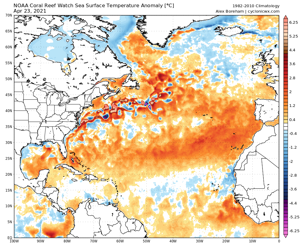
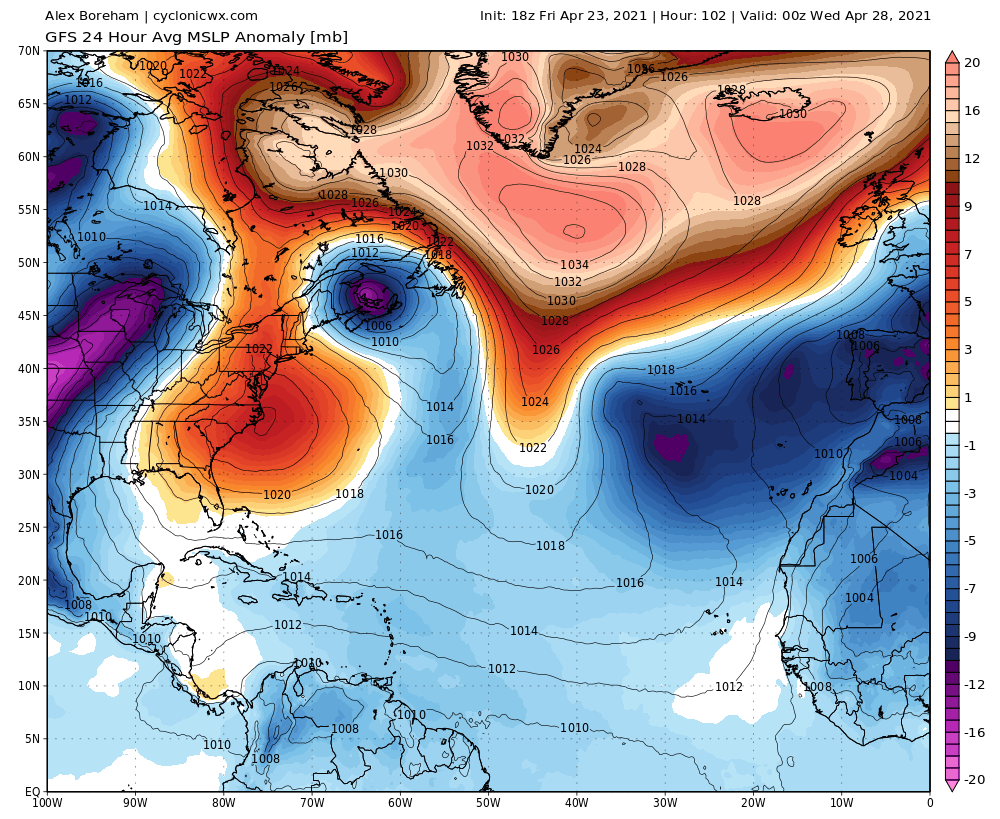
Just look at the similarity in location between the SSTAs and the low pressure! Seems to be some SST coupling here

Image

Image
0 likes   
This post was probably an opinion of mine, and in no way is official. Please refer to http://www.hurricanes.gov for official tropical analysis and advisories.

My website, with lots of tropical wx graphics, including satellite and recon: http://cyclonicwx.com

User avatar
cycloneye
Admin
Admin
Posts: 139080
Age: 67
Joined: Thu Oct 10, 2002 10:54 am
Location: San Juan, Puerto Rico

Re: 2021 Indicators: SST's / SAL / MSLP / Shear / Steering / Instability / Sat Images

#278 Postby cycloneye » Fri Apr 23, 2021 9:20 pm

1 likes   
Visit the Caribbean-Central America Weather Thread where you can find at first post web cams,radars
and observations from Caribbean basin members Click Here

Shell Mound
Category 5
Category 5
Posts: 2434
Age: 31
Joined: Thu Sep 07, 2017 3:39 pm
Location: St. Petersburg, FL → Scandinavia

Re: 2021 Indicators: SST's / SAL / MSLP / Shear / Steering / Instability / Sat Images

#279 Postby Shell Mound » Sat Apr 24, 2021 6:27 am

Image
Source

2021 has featured the ninth-highest ACE generation over the WPAC prior to 1 May. Of the top fifteen years on this spreadsheet, per ONI, nine ended up with El Niño: 1958, 1976, 1979, 1982, 1997, 2002, 2004, 2015, and (arguably) 2019. Three years—1956, 1962, and 1967—ended up with cool neutral ENSO. 1959 ended up with dead neutral ENSO, while 2003 ended up with warm neutral ENSO. So roughly two-thirds of the years ended up with either warm neutral or + ENSO. Therefore, I expect ENSO to play a role in counteracting the +AMO and active African monsoon by imparting convectively driven outflow and hence enhanced VWS, along with sinking air, over the Caribbean and westernmost MDR during ASO. However, the key is whether the warm anomalies in the equatorial Pacific will be concentrated in NINO 1/2 or NINO 3.4/4. If the latter, then VWS over the Caribbean and MDR would be much less. 1958, 2002, 2004, and 2019 each featured “Modoki”-type SST signatures in the equatorial Pacific during ASO. If one excludes these years as well as 2003 (whose warmest SST anomalies in the equatorial Pacific were also west-based) from the sample, then the remaining, east-based, + ENSO years—1976, 1979, 1982, 1997, and 2015—largely featured OTS MH tracks relative to the CONUS, aside from Frederic (1979). So east-based warm neutral or + ENSO is less favourable to MH landfalls and hyperactivity than west-based/“Modoki”-type warm neutral or + ENSO.
1 likes   
CVW / MiamiensisWx / Shell Mound
The posts in this forum are NOT official forecasts and should not be used as such. They are just the opinion of the poster and may or may not be backed by sound meteorological data. They are NOT endorsed by any professional institution or STORM2K. For official information, please refer to products from the NHC and NWS.

Shell Mound
Category 5
Category 5
Posts: 2434
Age: 31
Joined: Thu Sep 07, 2017 3:39 pm
Location: St. Petersburg, FL → Scandinavia

Re: 2021 Indicators: SST's / SAL / MSLP / Shear / Steering / Instability / Sat Images: IMME shows very favorable signal

#280 Postby Shell Mound » Sat Apr 24, 2021 6:52 am

jconsor wrote:Image

The +PMM signature, coupled with + anomalies in NINO 1/2, would likely favour more VWS, sinking air, and a stronger TUTT over the Caribbean and western MDR. As I mentioned previously, years with the warmest anomalies concentrated in NINO 1/2 also tend to feature fewer MH landfalls on the CONUS vs. west-based or “Modoki”-type warm neutral or + ENSO setups. So even with the active African monsoon and a +AMO in place (though the warm Gulf of Guinea is more of a -AMO look), the above configuration in the Pacific is not conducive to a highly impactful season in terms of MH impacts on the CONUS or the Caribbean. The Caribbean and southwestern Atlantic would be either hostile or blocked by a trough or both. 2018 did feature Michael and Florence, but it was a “Modoki”-type (west-based + ENSO) year, not an east-based warm neutral or + ENSO. A dangerous setup would be reversed, with the + anomalies in NINO 3.4/4 and the cool in NINO 1/2. (Incidentally, I don’t think a single Atlantic season with both ACE ≥ 150 and east-based warm neutral/+ ENSO has been registered since 1950. Yet CSU’s April forecast has consistently underestimated seasonal ACE since 2016, and this April’s forecast calls for hyperactivity and an ACE of 150.)
0 likes   
CVW / MiamiensisWx / Shell Mound
The posts in this forum are NOT official forecasts and should not be used as such. They are just the opinion of the poster and may or may not be backed by sound meteorological data. They are NOT endorsed by any professional institution or STORM2K. For official information, please refer to products from the NHC and NWS.


Return to “Talkin' Tropics”

Who is online

Users browsing this forum: Chris90, Dougiefresh, Google Adsense [Bot], tiger_deF and 182 guests