One year ago vs 2021.
https://twitter.com/philklotzbach/status/1450099687889928196
2021 Indicators: SST's / SAL / MSLP / Shear / Steering / Instability / Sat Images
Moderator: S2k Moderators
Forum rules

The posts in this forum are NOT official forecasts and should not be used as such. They are just the opinion of the poster and may or may not be backed by sound meteorological data. They are NOT endorsed by any professional institution or STORM2K. For official information, please refer to products from the National Hurricane Center and National Weather Service.
-
cycloneye

- Admin

- Posts: 139065
- Age: 67
- Joined: Thu Oct 10, 2002 10:54 am
- Location: San Juan, Puerto Rico
Re: 2021 Indicators: SST's / SAL / MSLP / Shear / Steering / Instability / Sat Images
1 likes
Visit the Caribbean-Central America Weather Thread where you can find at first post web cams,radars
and observations from Caribbean basin members Click Here
and observations from Caribbean basin members Click Here

Re: 2021 Indicators: SST's / SAL / MSLP / Shear / Steering / Instability / Sat Images
If I said in June that October would be dead in the Atlantic but have at least one EPac hurricane despite a La Niña, I would’ve been banned for trolling.
This makes no climo sense whatsoever. A La Niña with a favorable MJO phase in a season that has produced storms at near-record rates…you’d think that SOMETHING would form, even a little subtropical system that’s barely classifiable.
This makes no climo sense whatsoever. A La Niña with a favorable MJO phase in a season that has produced storms at near-record rates…you’d think that SOMETHING would form, even a little subtropical system that’s barely classifiable.
4 likes
Irene '11 Sandy '12 Hermine '16 5/15/2018 Derecho Fay '20 Isaias '20 Elsa '21 Henri '21 Ida '21
I am only a meteorology enthusiast who knows a decent amount about tropical cyclones. Look to the professional mets, the NHC, or your local weather office for the best information.
I am only a meteorology enthusiast who knows a decent amount about tropical cyclones. Look to the professional mets, the NHC, or your local weather office for the best information.
-
hurricanes1234
- Category 5

- Posts: 2903
- Joined: Sat Jul 28, 2012 6:19 pm
- Location: Trinidad and Tobago
Re: 2021 Indicators: SST's / SAL / MSLP / Shear / Steering / Instability / Sat Images
At this point, I would be genuinely surprised if we made it to the auxiliary list.
4 likes
PLEASE NOTE: With the exception of information from weather agencies that I may copy and paste here, my posts will NEVER be official, since I am NOT a meteorologist. They are solely my amateur opinion, and may or may not be accurate. Therefore, please DO NOT use them as official details, particularly when making important decisions. Thank you.
-
Category5Kaiju

- Category 5
- Posts: 3356
- Age: 22
- Joined: Thu Dec 24, 2020 12:45 pm
- Location: Seattle
Re: 2021 Indicators: SST's / SAL / MSLP / Shear / Steering / Instability / Sat Images
I am simply incapable of trying to make sense of what we are seeing now, not just the Atlantic but all three NH basins. I personally think there's something else aside from La Nina or MJO that is keeping all of these basins relatively quiet with no major strength cyclones capable of forming, and I don't know wtf that factor is. With regards to the Atlantic, even during an unfavorable MJO phase, you would expect at least one weak TS to occur, but that's not happening. You would also think that with a dead Atlantic the WPAC and EPAC would light up with activity and spit out tons of strong storms, but that has not been the case. In fact, as Phil Klotzbach showed, we have yet to see a major strength cyclone anywhere around the world since at least the first part of this month. And even with a La Nina, especially in October, the WPAC is usually capable of producing decent levels of activity (albeit west-based) and perhaps a strong storm or two as well, but that has not been the case either. In the Atlantic, it's not like the entire basin is under 25 knots of shear or more and blanketed with 2013-level dry air or a dearth of tropical waves. Storms simply are not forming, and I have zero idea as to why.
4 likes
Unless explicitly stated, all information covered in my posts is based on my opinions and observations. Please refer to a professional meteorologist or an accredited weather research agency otherwise, especially if serious decisions must be made in the event of a potentially life-threatening tropical storm or hurricane.
-
AlphaToOmega
- Category 5
- Posts: 1448
- Joined: Sat Jun 26, 2021 10:51 am
- Location: Somewhere in Massachusetts
Re: 2021 Indicators: SST's / SAL / MSLP / Shear / Steering / Instability / Sat Images
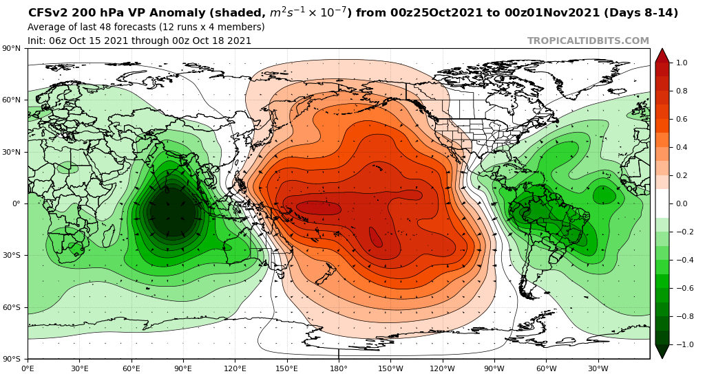
This is definitely something we need to consider: the CFSv2 is showing, as of now, very favorable VP patterns across the North Atlantic later this month.
We also need to consider some historical facts as regard to activity in October.
We also need to consider some historical facts as regard to activity in October.
- Ever since 2016, there has been at least one hurricane each October: Nicole (2016); Nate and Ophelia (2017); Michael and Oscar (2018); Pablo (2019); and Gamma, Delta, Epsilon, and Zeta (2020).
- Ever since 2017, every October has featured at least three storms: Nate, Ophelia, and Phillipe (2017); Michael, Nadine, and Oscar (2018); Melissa, Nestor, Olga, Pablo, and Rebekah (2019); and Gamma, Delta, Epsilon, and Zeta (2020).
- Every satellite-era +AMO season with -ENSO conditions not exceeding <-1.5 C (id est not a strong La Nina) featured a major hurricane in October: Roxanne (1995); Lili (1996); Iris (2001); Wilma and Beta (2005); Omar (2008); Rina (2011); Nichole (2016); Ophelia (2017); and Delta, Epsilon, and Zeta (2020).
1 likes
-
CyclonicFury

- Category 5
- Posts: 1975
- Age: 25
- Joined: Sun Jul 02, 2017 12:32 pm
- Location: NC
- Contact:
Re: 2021 Indicators: SST's / SAL / MSLP / Shear / Steering / Instability / Sat Images
AlphaToOmega wrote:This is definitely something we need to consider: the CFSv2 is showing, as of now, very favorable VP patterns across the North Atlantic later this month.
https://i.postimg.cc/K8vj4w95/cfs-avg-chi200-Mean-global-2.png
We also need to consider some historical facts as regard to activity in October.
- Ever since 2016, there has been at least one hurricane each October: Nicole (2016); Nate and Ophelia (2017); Michael and Oscar (2018); Pablo (2019); and Gamma, Delta, Epsilon, and Zeta (2020).
- Ever since 2017, every October has featured at least three storms: Nate, Ophelia, and Phillipe (2017); Michael, Nadine, and Oscar (2018); Melissa, Nestor, Olga, Pablo, and Rebekah (2019); and Gamma, Delta, Epsilon, and Zeta (2020).
- Every satellite-era +AMO season with -ENSO conditions not exceeding <-1.5 C (id est not a strong La Nina) featured a major hurricane in October: Roxanne (1995); Lili (1996); Iris (2001); Wilma and Beta (2005); Omar (2008); Rina (2011); Nichole (2016); Ophelia (2017); and Delta, Epsilon, and Zeta (2020).
I think it's also important to consider that aside from 2011, none of those years mentioned had no TC formations between October 1-18. It looks very unlikely we see anything form in the next five days, either. So there's an increasing chance we go all of the month without a named storm formation in the Atlantic. That would be incredibly unusual for a -ENSO year, especially a season that was on pace to get deep into the auxiliary list. I'd be very shocked if October had more than one storm at this point. It looks like there may be a narrow window for a Caribbean storm in late October/early November when shear is below average, but the models have not latched onto anything consistently.
4 likes
NCSU B.S. in Meteorology Class of 2021. Tropical weather blogger at http://www.cyclonicfury.com. My forecasts and thoughts are NOT official, for official forecasts please consult the National Hurricane Center.
-
Iceresistance

- Category 5
- Posts: 8911
- Age: 20
- Joined: Sat Oct 10, 2020 9:45 am
- Location: Tecumseh, OK/Norman, OK
Re: 2021 Indicators: SST's / SAL / MSLP / Shear / Steering / Instability / Sat Images
Category5Kaiju wrote:I am simply incapable of trying to make sense of what we are seeing now, not just the Atlantic but all three NH basins. I personally think there's something else aside from La Nina or MJO that is keeping all of these basins relatively quiet with no major strength cyclones capable of forming, and I don't know wtf that factor is. With regards to the Atlantic, even during an unfavorable MJO phase, you would expect at least one weak TS to occur, but that's not happening. You would also think that with a dead Atlantic the WPAC and EPAC would light up with activity and spit out tons of strong storms, but that has not been the case. In fact, as Phil Klotzbach showed, we have yet to see a major strength cyclone anywhere around the world since at least the first part of this month. And even with a La Nina, especially in October, the WPAC is usually capable of producing decent levels of activity (albeit west-based) and perhaps a strong storm or two as well, but that has not been the case either. In the Atlantic, it's not like the entire basin is under 25 knots of shear or more and blanketed with 2013-level dry air or a dearth of tropical waves. Storms simply are not forming, and I have zero idea as to why.
Nothing made sense anymore after what happened in 2020
But this has taken it to another level! Last Time I recall that the entire world was dead in TC activity for an extended period of time was in 2010
4 likes
Bill 2015 & Beta 2020
Winter 2020-2021
All observations are in Tecumseh, OK unless otherwise noted.
Winter posts are focused mainly for Oklahoma & Texas.
Take any of my forecasts with a grain of salt, refer to the NWS, SPC, and NHC for official information
Never say Never with weather! Because ANYTHING is possible!
Winter 2020-2021
All observations are in Tecumseh, OK unless otherwise noted.
Winter posts are focused mainly for Oklahoma & Texas.
Take any of my forecasts with a grain of salt, refer to the NWS, SPC, and NHC for official information
Never say Never with weather! Because ANYTHING is possible!

Re: 2021 Indicators: SST's / SAL / MSLP / Shear / Steering / Instability / Sat Images
Browsing satellite images of the Atlantic and there's a blob off the coast of South America, looked a bit closer and noticed a bit of movement. The area is low shear at the moment and ASCAT passes have shown 25 knot winds but with the place it's in it's most likely to move inland. The Atlantic isn't dead yet.
Source GOES-16 - https://col.st/VOKRU
Source GOES-16 - https://col.st/VOKRU
0 likes
Re: 2021 Indicators: SST's / SAL / MSLP / Shear / Steering / Instability / Sat Images
Perhaps something is changing with the global base state that’ll continue into 2022. Does anyone know how the THC is doing? I know THC collapse gets tossed around all the time and never happens, but with such an abnormal lull in activity that defies climo, it’s for once not totally out of the question.
0 likes
Irene '11 Sandy '12 Hermine '16 5/15/2018 Derecho Fay '20 Isaias '20 Elsa '21 Henri '21 Ida '21
I am only a meteorology enthusiast who knows a decent amount about tropical cyclones. Look to the professional mets, the NHC, or your local weather office for the best information.
I am only a meteorology enthusiast who knows a decent amount about tropical cyclones. Look to the professional mets, the NHC, or your local weather office for the best information.
-
AlphaToOmega
- Category 5
- Posts: 1448
- Joined: Sat Jun 26, 2021 10:51 am
- Location: Somewhere in Massachusetts
Re: 2021 Indicators: SST's / SAL / MSLP / Shear / Steering / Instability / Sat Images
The MJO is not very favorable for Atlantic tropical cyclogenesis. Need I say more?
Occam's Razor, people!
Occam's Razor, people!
0 likes
-
Category5Kaiju
- Category 5
- Posts: 3356
- Age: 22
- Joined: Thu Dec 24, 2020 12:45 pm
- Location: Seattle
Re: 2021 Indicators: SST's / SAL / MSLP / Shear / Steering / Instability / Sat Images
aspen wrote:Perhaps something is changing with the global base state that’ll continue into 2022. Does anyone know how the THC is doing? I know THC collapse gets tossed around all the time and never happens, but with such an abnormal lull in activity that defies climo, it’s for once not totally out of the question.
From my understanding, one could not have predicted a 2013 given how 2012 finished off, with major strength cyclones and fair amounts of activity seen in all 3 NH basins in October (in other words, 2012 ended and behaved like a typical year would have). The best analog I can think of for what we are seeing now is 2007, and even then activity was fairly decent in the WPAC while the EPAC and Atlantic were quiet. 2008 of course turned out to be a very active Atlantic year, with the WPAC and EPAC being below average but featuring their fair share of powerful storms. I think it's too early to say that what we are seeing now is going to lead to a 2013 repeat next year, and especially with individual hurricane/typhoon season behavior, because each year is so unique in the sequence of storms, their strengths, where they hit, etc., historical seasons can only go so far in serving as useful predictions for what to expect exactly in future seasons.
I think it is also important to understand that a THC collapse as severe and unexpected as 2013 should not be expected to occur during any given year. The way I see it is that the conditions that caused 2013 to occur were highly unique and fortuitious, and imho saying in a given year that another 2005 will happen or that another 2013 will happen are just things one should never say given how unlikely such extreme events are to occur in the first place in any year.
4 likes
Unless explicitly stated, all information covered in my posts is based on my opinions and observations. Please refer to a professional meteorologist or an accredited weather research agency otherwise, especially if serious decisions must be made in the event of a potentially life-threatening tropical storm or hurricane.

Re: 2021 Indicators: SST's / SAL / MSLP / Shear / Steering / Instability / Sat Images
Category5Kaiju wrote:and imho saying in a given year that another 2005 will happen or that another 2013 will happen are just things one should never say given how unlikely such extreme events are to occur in the first place in any year.
After what happened in 2021, we can add 2020 to the list. I know some weather enthusiasts here were at least somewhat disappointed with 2020 after it ended, given the relatively lackluster MDR season (by hyperactive standards), lack of an ultra-intense Cat 5, lots of weak storms, and lower ACE than one might expect for a season with 30 NS.
Well, I think now everyone knows that even with all these not-as-impressive issues, a season like 2020 is as extraordinary as one can get, especially its late season. 2021 was at one point on par to becoming a 2020 repeat, and we have now seen how that turned out (minus possible November and extreme late October activities).
0 likes
-
Category5Kaiju
- Category 5
- Posts: 3356
- Age: 22
- Joined: Thu Dec 24, 2020 12:45 pm
- Location: Seattle
Re: 2021 Indicators: SST's / SAL / MSLP / Shear / Steering / Instability / Sat Images
It’s also imho important to understand that even if this season just somehow abruptly ends with no more activity that occurs, it will be the 4th costliest season recorded and 3rd most active NS wise recorded, and much like Camille of 1969, Carmen of 1974, Anita of 1977, Allen of 1980, Hugo of 1989, Andrew of 1992, or Dorian of 2019, Ida will be 2021’s “flag-bearer.” Now hopefully there are no more major hurricane threats this season, although I as well as many others will be eating crow if this season decides to pull a dirty truck on us and generate a powerful November hurricane in the W Atlantic. 
1 likes
Unless explicitly stated, all information covered in my posts is based on my opinions and observations. Please refer to a professional meteorologist or an accredited weather research agency otherwise, especially if serious decisions must be made in the event of a potentially life-threatening tropical storm or hurricane.


Re: 2021 Indicators: SST's / SAL / MSLP / Shear / Steering / Instability / Sat Images
Category5Kaiju wrote:I am simply incapable of trying to make sense of what we are seeing now, not just the Atlantic but all three NH basins. I personally think there's something else aside from La Nina or MJO that is keeping all of these basins relatively quiet with no major strength cyclones capable of forming, and I don't know wtf that factor is. With regards to the Atlantic, even during an unfavorable MJO phase, you would expect at least one weak TS to occur, but that's not happening. You would also think that with a dead Atlantic the WPAC and EPAC would light up with activity and spit out tons of strong storms, but that has not been the case. In fact, as Phil Klotzbach showed, we have yet to see a major strength cyclone anywhere around the world since at least the first part of this month. And even with a La Nina, especially in October, the WPAC is usually capable of producing decent levels of activity (albeit west-based) and perhaps a strong storm or two as well, but that has not been the case either. In the Atlantic, it's not like the entire basin is under 25 knots of shear or more and blanketed with 2013-level dry air or a dearth of tropical waves. Storms simply are not forming, and I have zero idea as to why.
I guess there's a slight possibility the Cumbre Vieja eruption is playing a small part, but it really hasn't pumped that much sulfur dioxide into the atmosphere (relatively speaking).
1 likes
-
AlphaToOmega
- Category 5
- Posts: 1448
- Joined: Sat Jun 26, 2021 10:51 am
- Location: Somewhere in Massachusetts
Re: 2021 Indicators: SST's / SAL / MSLP / Shear / Steering / Instability / Sat Images
At this point, I feel like we forgot that the MJO exists. 
0 likes
-
Category5Kaiju
- Category 5
- Posts: 3356
- Age: 22
- Joined: Thu Dec 24, 2020 12:45 pm
- Location: Seattle
Re: 2021 Indicators: SST's / SAL / MSLP / Shear / Steering / Instability / Sat Images
AlphaToOmega wrote:At this point, I feel like we forgot that the MJO exists.
I, along with I am sure many others on Storm2k, are still very aware of the MJO. Like I said earlier, if we do see activity come back to life near the end of this month/early November, then I think this season's heavy MJO dependence can be blamed for the lack of October activity, much like we could say for why there were no named storms in most of July and very early August. But in the very unusual event that activity does not come back to life again later this month and in early November, then at that point I think we can shift the blame on the MJO dependence to something else that I personally am not aware of but seems to be defying climatology, which in itself is no easy task.
2 likes
Unless explicitly stated, all information covered in my posts is based on my opinions and observations. Please refer to a professional meteorologist or an accredited weather research agency otherwise, especially if serious decisions must be made in the event of a potentially life-threatening tropical storm or hurricane.
Re: 2021 Indicators: SST's / SAL / MSLP / Shear / Steering / Instability / Sat Images
AlphaToOmega wrote:At this point, I feel like we forgot that the MJO exists.
I think the atmosphere forgot the MJO exists lol
0 likes
Irene '11 Sandy '12 Hermine '16 5/15/2018 Derecho Fay '20 Isaias '20 Elsa '21 Henri '21 Ida '21
I am only a meteorology enthusiast who knows a decent amount about tropical cyclones. Look to the professional mets, the NHC, or your local weather office for the best information.
I am only a meteorology enthusiast who knows a decent amount about tropical cyclones. Look to the professional mets, the NHC, or your local weather office for the best information.

Re: 2021 Indicators: SST's / SAL / MSLP / Shear / Steering / Instability / Sat Images
Category5Kaiju wrote:aspen wrote:Perhaps something is changing with the global base state that’ll continue into 2022. Does anyone know how the THC is doing? I know THC collapse gets tossed around all the time and never happens, but with such an abnormal lull in activity that defies climo, it’s for once not totally out of the question.
From my understanding, one could not have predicted a 2013 given how 2012 finished off, with major strength cyclones and fair amounts of activity seen in all 3 NH basins in October (in other words, 2012 ended and behaved like a typical year would have). The best analog I can think of for what we are seeing now is 2007, and even then activity was fairly decent in the WPAC while the EPAC and Atlantic were quiet. 2008 of course turned out to be a very active Atlantic year, with the WPAC and EPAC being below average but featuring their fair share of powerful storms. I think it's too early to say that what we are seeing now is going to lead to a 2013 repeat next year, and especially with individual hurricane/typhoon season behavior, because each year is so unique in the sequence of storms, their strengths, where they hit, etc., historical seasons can only go so far in serving as useful predictions for what to expect exactly in future seasons.
I think it is also important to understand that a THC collapse as severe and unexpected as 2013 should not be expected to occur during any given year. The way I see it is that the conditions that caused 2013 to occur were highly unique and fortuitious, and imho saying in a given year that another 2005 will happen or that another 2013 will happen are just things one should never say given how unlikely such extreme events are to occur in the first place in any year.
Regarding the THC collapse, it's best not to use it as a prediction tool, and really impossible to determine 8-10 months out if it'll be a factor in next hurricane season. However it's a good question to ask as far as present conditions go--in 2013 it occurred during springtime, and had continuing effects into summer. I don't know what the SST pattern was that related to that, rather than other cycles, nor do I know where to find archival SST maps for this year, but it's certainly something that should would warrant after the fact investigating, especially given one of the more noticeable things outside of hurricane activity was the upper air pattern and fronts not matching with the seasons.
0 likes
The above post is not official and should not be used as such. It is the opinion of the poster and may or may not be backed by sound meteorological data. It is not endorsed by any professional institution or storm2k.org. For official information, please refer to the NHC and NWS products.

Re: 2021 Indicators: SST's / SAL / MSLP / Shear / Steering / Instability / Sat Images
Hammy wrote:Category5Kaiju wrote:aspen wrote:Perhaps something is changing with the global base state that’ll continue into 2022. Does anyone know how the THC is doing? I know THC collapse gets tossed around all the time and never happens, but with such an abnormal lull in activity that defies climo, it’s for once not totally out of the question.
From my understanding, one could not have predicted a 2013 given how 2012 finished off, with major strength cyclones and fair amounts of activity seen in all 3 NH basins in October (in other words, 2012 ended and behaved like a typical year would have). The best analog I can think of for what we are seeing now is 2007, and even then activity was fairly decent in the WPAC while the EPAC and Atlantic were quiet. 2008 of course turned out to be a very active Atlantic year, with the WPAC and EPAC being below average but featuring their fair share of powerful storms. I think it's too early to say that what we are seeing now is going to lead to a 2013 repeat next year, and especially with individual hurricane/typhoon season behavior, because each year is so unique in the sequence of storms, their strengths, where they hit, etc., historical seasons can only go so far in serving as useful predictions for what to expect exactly in future seasons.
I think it is also important to understand that a THC collapse as severe and unexpected as 2013 should not be expected to occur during any given year. The way I see it is that the conditions that caused 2013 to occur were highly unique and fortuitious, and imho saying in a given year that another 2005 will happen or that another 2013 will happen are just things one should never say given how unlikely such extreme events are to occur in the first place in any year.
Regarding the THC collapse, it's best not to use it as a prediction tool, and really impossible to determine 8-10 months out if it'll be a factor in next hurricane season. However it's a good question to ask as far as present conditions go--in 2013 it occurred during springtime, and had continuing effects into summer. I don't know what the SST pattern was that related to that, rather than other cycles, nor do I know where to find archival SST maps for this year, but it's certainly something that should would warrant after the fact investigating, especially given one of the more noticeable things outside of hurricane activity was the upper air pattern and fronts not matching with the seasons.
https://coralreefwatch.noaa.gov/product/5km/
Regarding archival SST maps. Scroll down on this page(from link above) to the Archive section. The section marked:
CoralTemp-derived Coral Bleaching Heat Stress Product Images
Will have SST anomalies and SST trend archive images for different regions. You can play around with it to see all the options it has.
There's another section above that that has just SSTs instead of anomalies and trends.
0 likes
Solar Aquarian
Lunar Cancerian
 Sagittarian
Lunar Cancerian