
I think Alpha is going to be right about 2021 rivaling 2005 and 2020 in NS count. This spike in activity does seem to be correlated with a weak Kelvin Wave, but it’s during a not very favorable MJO background state. That just makes the fact that we’re already at Sam and Teresa even more impressive, and is a concerning sign for later on.
The Euro VP anomaly map (which I don’t have on me but has been posted in the model thread) shows a HUGE enhanced phase in the western Atlantic for the middle third of October, with two other weak favorable Kelvin Waves during the next six weeks, one before and one after the mid October phase. Seeing how we’re gonna have a major within 24 hours, the activity spike coming up could be very significant. I’ll bet we get 1-2 more majors and the first storms of the new auxiliary list then.
2021 Indicators: SST's / SAL / MSLP / Shear / Steering / Instability / Sat Images
Moderator: S2k Moderators
Forum rules

The posts in this forum are NOT official forecasts and should not be used as such. They are just the opinion of the poster and may or may not be backed by sound meteorological data. They are NOT endorsed by any professional institution or STORM2K. For official information, please refer to products from the National Hurricane Center and National Weather Service.
Re: 2021 Indicators: SST's / SAL / MSLP / Shear / Steering / Instability / Sat Images
5 likes
Irene '11 Sandy '12 Hermine '16 5/15/2018 Derecho Fay '20 Isaias '20 Elsa '21 Henri '21 Ida '21
I am only a meteorology enthusiast who knows a decent amount about tropical cyclones. Look to the professional mets, the NHC, or your local weather office for the best information.
I am only a meteorology enthusiast who knows a decent amount about tropical cyclones. Look to the professional mets, the NHC, or your local weather office for the best information.
-
AlphaToOmega
- Category 5

- Posts: 1448
- Joined: Sat Jun 26, 2021 10:51 am
- Location: Somewhere in Massachusetts
Re: 2021 Indicators: SST's / SAL / MSLP / Shear / Steering / Instability / Sat Images
We are in a very similar place as we were with 2020. We are only 3 storms behind, 1 hurricane behind, and 1 major hurricane ahead.
2021 as of September 24: 19 storms, 7 hurricanes, and 3 major hurricanes
2020 as of September 24: 22 storms, 8 hurricanes, and 2 major hurricanes
2005 as of September 24: 17 storms, 9 hurricanes, and 5 major hurricanes
We will have a better idea of where this hurricane season will be come the end of October. The ECMWF indicates a favorable VP pattern throughout October, and the GFS indicates below-average MSLP throughout the tropical Atlantic during October, both of which favor Atlantic tropical cyclogenesis. October 2005 provided that season with a major quantity boost, and October 2020 provided that season with a major quality boost. What happens this October will determine if the season is just above-average, hyperactive, or historic.
October will also be a key month in terms of land impacts. Aside from Ida, there have not been any significant landfalling storms. However, because climatology favors Caribbean/Gulf of Mexico development during October, storms that do develop during October will pose greater threats to land than storms that do not. This hurricane season is proving to be very active, damaging, and deadly; and if the favorable pattern for October verifies, that trend would likely continue.
There is also the question of November and December, but that is a month away.
TL;DR: This season is no 1983.
4 likes
-
Category5Kaiju

- Category 5
- Posts: 3355
- Age: 22
- Joined: Thu Dec 24, 2020 12:45 pm
- Location: Seattle
Re: 2021 Indicators: SST's / SAL / MSLP / Shear / Steering / Instability / Sat Images
To be fair, with the expected activity for October, it would not surprise me to see at least one impactful and powerful major hurricane in the West Atlantic with an auxiliary list name. All the more reason to believe that the WMO’s decision to discontinue Greek naming earlier this year was a legitimately good choice.
0 likes
Unless explicitly stated, all information covered in my posts is based on my opinions and observations. Please refer to a professional meteorologist or an accredited weather research agency otherwise, especially if serious decisions must be made in the event of a potentially life-threatening tropical storm or hurricane.

Re: 2021 Indicators: SST's / SAL / MSLP / Shear / Steering / Instability / Sat Images
Category5Kaiju wrote:To be fair, with the expected activity for October, it would not surprise me to see at least one impactful and powerful major hurricane in the West Atlantic with an auxiliary list name. All the more reason to believe that the WMO’s decision to discontinue Greek naming earlier this year was a legitimately good choice.
Before they announced the auxiliary list earlier this year, I was expecting them to decide on making a new auxiliary list but not actually have the names ready for a year (like they do to WPac replacements), since getting 45 new names in such a short time span was not an easy task.
Now I'm really glad they managed to pull it off. Imagine if we get another bad Delta or Zeta this year...
0 likes
-
tolakram
- Admin

- Posts: 19165
- Age: 60
- Joined: Sun Aug 27, 2006 8:23 pm
- Location: Florence, KY (name is Mark)
Re: 2021 Indicators: SST's / SAL / MSLP / Shear / Steering / Instability / Sat Images
Storm count is meaningless, we're going to use up the names every year. If we can agree that X hurricanes is different from X tropical storms in the same period then we're on the same page.
Let me quote the prediction.
5 storms have formed since September 15th, Teresa being the latest, a subtropical storm. 6 days to go.
Let me quote the prediction.
tolakram wrote:AlphaToOmega wrote:Let me repeat it again: just because we do not see activity in the next few days DOES NOT mean September will be dead. As shown a few weeks ago, lots of storms can form within a very short amount of time (~2 weeks). I expect a couple storms (2-3) to form before September 15, but I think September 15-30 will see 5-8 storms. No matter how you slice it, you cannot fight against the climatological peak of hurricane season. Therefore, I still think September as a whole will be very active, just like in 2007, 2010, 2018, 2019, and 2020.
-snip- We are in peak season with a major hurricane in the Atlantic and models showing very little. What they did show they backed off on. Face it, every prognostication up to this point has been wrong. No strong hurricanes, no large hurricanes, season will be super busy! 5 to 8 storms in a 15 day period would be quite insane, and if you step back a second you will have to admit nearly impossible. Not every season is going to be mega hyper active, regardless of the indicators. There are multiple pieces of the puzzle we do not understand. What makes a season more or less active than we think it will be is what makes hurricanes seasons interesting, IMO. It will do what it will do, regardless.
5 storms have formed since September 15th, Teresa being the latest, a subtropical storm. 6 days to go.
2 likes
M a r k
- - - - -
Join us in chat: Storm2K Chatroom Invite. Android and IOS apps also available.
The posts in this forum are NOT official forecasts and should not be used as such. Posts are NOT endorsed by any professional institution or STORM2K.org. For official information and forecasts, please refer to NHC and NWS products.
-
AlphaToOmega
- Category 5
- Posts: 1448
- Joined: Sat Jun 26, 2021 10:51 am
- Location: Somewhere in Massachusetts
Re: 2021 Indicators: SST's / SAL / MSLP / Shear / Steering / Instability / Sat Images
tolakram wrote:Storm count is meaningless, we're going to use up the names every year. If we can agree that X hurricanes is different from X tropical storms in the same period then we're on the same page.
Let me quote the prediction.tolakram wrote:AlphaToOmega wrote:Let me repeat it again: just because we do not see activity in the next few days DOES NOT mean September will be dead. As shown a few weeks ago, lots of storms can form within a very short amount of time (~2 weeks). I expect a couple storms (2-3) to form before September 15, but I think September 15-30 will see 5-8 storms. No matter how you slice it, you cannot fight against the climatological peak of hurricane season. Therefore, I still think September as a whole will be very active, just like in 2007, 2010, 2018, 2019, and 2020.
-snip- We are in peak season with a major hurricane in the Atlantic and models showing very little. What they did show they backed off on. Face it, every prognostication up to this point has been wrong. No strong hurricanes, no large hurricanes, season will be super busy! 5 to 8 storms in a 15 day period would be quite insane, and if you step back a second you will have to admit nearly impossible. Not every season is going to be mega hyper active, regardless of the indicators. There are multiple pieces of the puzzle we do not understand. What makes a season more or less active than we think it will be is what makes hurricanes seasons interesting, IMO. It will do what it will do, regardless.
5 storms have formed since September 15th, Teresa being the latest, a subtropical storm. 6 days to go.
You have to admit that my prediction was correct, though.
7 likes
Re: 2021 Indicators: SST's / SAL / MSLP / Shear / Steering / Instability / Sat Images
I find it hard to believe that in a borderline La Nina there wont be in the W Caribbean at least one H, probably major especially with SST's there now the warmest of the season and now warming even further due to a lack of storminess expected there the next 10+ days:
9/23/21 SSTs: although it has cooled some along the N Gulf coast and off N FL due to the cooler air, it is now the warmest of the season W Caribbean to the FL Straits and also off SW FL:

9/23/21 SSTs: although it has cooled some along the N Gulf coast and off N FL due to the cooler air, it is now the warmest of the season W Caribbean to the FL Straits and also off SW FL:
1 likes
Personal Forecast Disclaimer:
The posts in this forum are NOT official forecasts and should not be used as such. They are just the opinion of the poster and may or may not be backed by sound meteorological data. They are NOT endorsed by any professional institution or storm2k.org. For official information, please refer to the NHC and NWS products.
The posts in this forum are NOT official forecasts and should not be used as such. They are just the opinion of the poster and may or may not be backed by sound meteorological data. They are NOT endorsed by any professional institution or storm2k.org. For official information, please refer to the NHC and NWS products.


Re: 2021 Indicators: SST's / SAL / MSLP / Shear / Steering / Instability / Sat Images
LarryWx wrote:I find it hard to believe that in a borderline La Nina there wont be in the W Caribbean at least one H, probably major especially with SST's there now the warmest of the season and now warming even further due to a lack of storminess expected there the next 10+ days:
9/23/21 SSTs: although it has cooled some along the N Gulf coast and off N FL due to the cooler air, it is now the warmest of the season W Caribbean to the FL Straits and also off SW FL:
https://i.imgur.com/ocllNd2.gif
I'm on the same train of thought. GFS fantasy land getting spicy which means nothing really except we are in a 2nd year La Nina and shear is going to be low over the Caribbean Sea as a result, not to mention the Atlantic is near record warm right now just following behind 2005. Something is coming I am sure of it. Where and when? Might as well throw a dart at a moving dart board in a dark room while blind folded.
1 likes
-
AlphaToOmega
- Category 5
- Posts: 1448
- Joined: Sat Jun 26, 2021 10:51 am
- Location: Somewhere in Massachusetts
Re: 2021 Indicators: SST's / SAL / MSLP / Shear / Steering / Instability / Sat Images
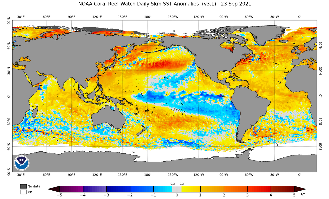
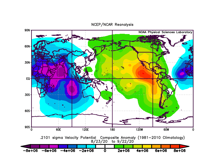
In a sense, the amount of storms, hurricanes, and major hurricanes this hurricane season has produced makes sense. SST patterns are certainly very conducive for tropical cyclogenesis in the North Atlantic. The MDR is close to record-breaking SSTAs; there is a strong negative PDO and a strong negative ENSO signal; and the IOD is negative.
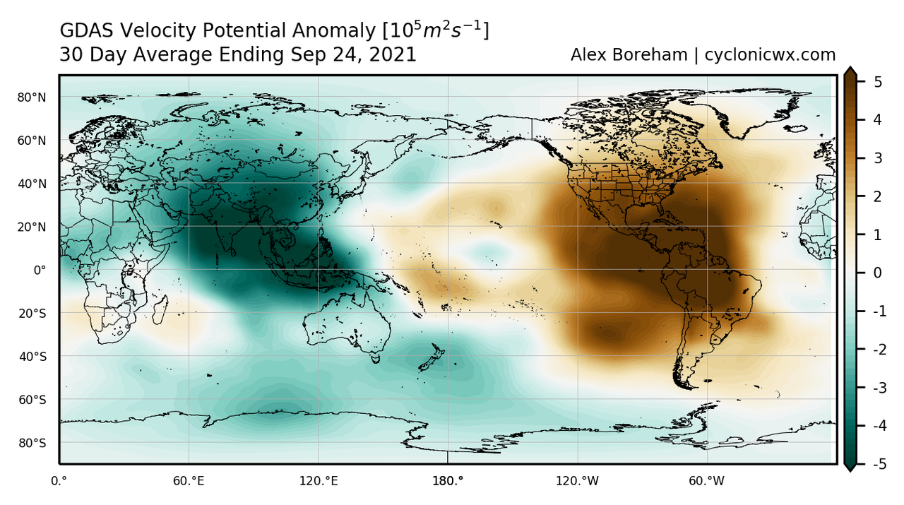
The forecasted VP pattern is also conducive for tropical cyclogenesis. Negative VP over Afro-Eurasia and Positive VP over the Americas is the most favorable pattern possible, which is what is shown here.
The forecasted VP pattern is also conducive for tropical cyclogenesis. Negative VP over Afro-Eurasia and Positive VP over the Americas is the most favorable pattern possible, which is what is shown here.
3 likes
-
AxaltaRacing24
- Category 5
- Posts: 1709
- Age: 23
- Joined: Wed Jul 27, 2016 11:14 am
- Location: Jupiter, FL
Re: 2021 Indicators: SST's / SAL / MSLP / Shear / Steering / Instability / Sat Images
AlphaToOmega wrote:In a sense, the amount of storms, hurricanes, and major hurricanes this hurricane season has produced makes sense. SST patterns are certainly very conducive for tropical cyclogenesis in the North Atlantic. The MDR is close to record-breaking SSTAs; there is a strong negative PDO and a strong negative ENSO signal; and the IOD is negative.
https://i.postimg.cc/jqv3kmFT/ct5km-ssta-v3-1-global-current.png
The forecasted VP pattern is also conducive for tropical cyclogenesis. Negative VP over Afro-Eurasia and Positive VP over the Americas is the most favorable pattern possible, which is what is shown here.
https://i.postimg.cc/cCmJQ0xr/vp-30day-anom.png
lol it is absolutely insane that we currently have a more favorable look than 2020 during this period.
0 likes
-
AlphaToOmega
- Category 5
- Posts: 1448
- Joined: Sat Jun 26, 2021 10:51 am
- Location: Somewhere in Massachusetts
Re: 2021 Indicators: SST's / SAL / MSLP / Shear / Steering / Instability / Sat Images
2021 and 2020 resemble each other a lot.
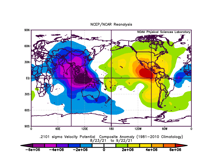
Here is the general pattern for 2021:
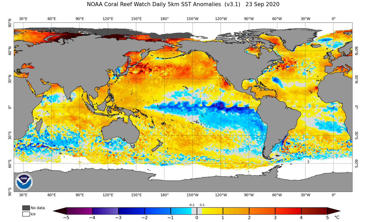
Here is the general pattern for 2020:
Here is the general pattern for 2021:
Here is the general pattern for 2020:
1 likes
-
AlphaToOmega
- Category 5
- Posts: 1448
- Joined: Sat Jun 26, 2021 10:51 am
- Location: Somewhere in Massachusetts
Re: 2021 Indicators: SST's / SAL / MSLP / Shear / Steering / Instability / Sat Images
I know many of you vehemently dislike using storm count as an indication of activity, but in terms of major hurricanes, 2021 is not doing that bad. This season has 4 major hurricanes and 19 storms so far. At this point, 2020 had 2 major hurricanes and 22 storms. At this point, 2005 had 5 major hurricanes and 17 storms. I feel comfortable comparing 2021 with 2020 and with 2005 because technology and naming standards are likely not that different among 2005, 2020, and 2021.
1 likes
-
Category5Kaiju
- Category 5
- Posts: 3355
- Age: 22
- Joined: Thu Dec 24, 2020 12:45 pm
- Location: Seattle
Re: 2021 Indicators: SST's / SAL / MSLP / Shear / Steering / Instability / Sat Images
AlphaToOmega wrote:I know many of you vehemently dislike using storm count as an indication of activity, but in terms of major hurricanes, 2021 is not doing that bad. This season has 4 major hurricanes and 19 storms so far. At this point, 2020 had 2 major hurricanes and 22 storms. At this point, 2005 had 5 major hurricanes and 17 storms. I feel comfortable comparing 2021 with 2020 and with 2005 because technology and naming standards are likely not that different among 2005, 2020, and 2021.
Even weak spin ups that get named as they fit the criteria for a TS during unfavorable MJO/CCKW phases means a lot more than the same happening and no NSs coming out of such. 2021's baseline state is extremely favorable as this shows; it also looks like 2021 is going to join 2005 and 2020's league of seasons with a mega count of NSs. I mean, this is not something many seasons in the recorded past have done, getting more than 20 NSs.
2 likes
Unless explicitly stated, all information covered in my posts is based on my opinions and observations. Please refer to a professional meteorologist or an accredited weather research agency otherwise, especially if serious decisions must be made in the event of a potentially life-threatening tropical storm or hurricane.
Re: 2021 Indicators: SST's / SAL / MSLP / Shear / Steering / Instability / Sat Images
AlphaToOmega wrote:I know many of you vehemently dislike using storm count as an indication of activity, but in terms of major hurricanes, 2021 is not doing that bad. This season has 4 major hurricanes and 19 storms so far. At this point, 2020 had 2 major hurricanes and 22 storms. At this point, 2005 had 5 major hurricanes and 17 storms. I feel comfortable comparing 2021 with 2020 and with 2005 because technology and naming standards are likely not that different among 2005, 2020, and 2021.
Agreed. 4 major hurricanes is already above average and we are not even through September yet. I'd be shocked if we didn't see 1-2 more majors.
1 likes
-
Category5Kaiju
- Category 5
- Posts: 3355
- Age: 22
- Joined: Thu Dec 24, 2020 12:45 pm
- Location: Seattle
Re: 2021 Indicators: SST's / SAL / MSLP / Shear / Steering / Instability / Sat Images
At this point I am solidly predicting 6 major hurricanes to come out of this season in the end. I even feel that only getting one more major after Sam is somewhat hard to believe. Heck, if we were to get 7 by the end, I cannot say that I'd be surprised.
1 likes
Unless explicitly stated, all information covered in my posts is based on my opinions and observations. Please refer to a professional meteorologist or an accredited weather research agency otherwise, especially if serious decisions must be made in the event of a potentially life-threatening tropical storm or hurricane.
-
AlphaToOmega
- Category 5
- Posts: 1448
- Joined: Sat Jun 26, 2021 10:51 am
- Location: Somewhere in Massachusetts
Re: 2021 Indicators: SST's / SAL / MSLP / Shear / Steering / Instability / Sat Images
Do not quote me on this, but here is how I think how the rest of September, October, November, and December will play out:
Forecasted season totals: 26-32 storms, 11-16 hurricanes, and 6-8 major hurricanes
- Rest of September (September 25-30): Another storm (Victor) will likely form during this time frame in MDR. Models indicate that the 0/50 AoI will become Tropical Storm/Hurricane Victor.
- Early October (October 1-10): Three or four storms will likely form during this time frame, with two or three being hurricanes, and one major hurricane. The CFS and ECMWF indicate favorable VP and MSLP patterns throughout October. October might be more active than August; for MDR SSTs typically peak in early October, and SAL is likely not going to be a factor. However, a less favorable climatology should prevent October from being more active than September.
- Mid October (October 11-20): Two or three storms will likely form during this time frame, with one or two being major hurricanes. The burst of activity will likely continue into mid-October. Climatology is still favorable during this time of year.
- Late October (October 21-31): Zero or one storm will likely form during this time frame; if it forms, this storm could become a hurricane. The ECMWF and CFS both suggest less favorable VP and MSLP patterns during this time period; and falling SSTs and a generally less favorable climatology should prevent late October from being very active.
- Early November (November 1-10): Zero storms will likely form during this time frame, for forecasted unfavorable VP patterns and climatology should stop any activity during this time frame.
- Mid November (November 11-20): Zero or one storm will likely form during this time frame, but it will likely not become a hurricane. This is based on the fact that 2021 is having a progression similar to 2016, with late November 2016 featuring storm formation.
- Late November (November 21-30): One or two storms will likely form during this time frame, with one or two being hurricanes, and zero or one being a major hurricane a là Major Hurricane Otto (2016).
- Early December (December 1-10): Zero or one storm will likely form during this time frame. Expected favorable conditions in late November could continue into December, fostering tropical cyclogenesis. However, an unfavorable climatology should prevent further activity in December.
- After December 10: No activity is expected.
Forecasted season totals: 26-32 storms, 11-16 hurricanes, and 6-8 major hurricanes
2 likes


Re: 2021 Indicators: SST's / SAL / MSLP / Shear / Steering / Instability / Sat Images
AlphaToOmega wrote:Do not quote me on this, but here is how I think how the rest of September, October, November, and December will play out:
- Rest of September (September 25-30): Another storm (Victor) will likely form during this time frame in MDR. Models indicate that the 0/50 AoI will become Tropical Storm/Hurricane Victor.
- Early October (October 1-10): Three or four storms will likely form during this time frame, with two or three being hurricanes, and one major hurricane. The CFS and ECMWF indicate favorable VP and MSLP patterns throughout October. October might be more active than August; for MDR SSTs typically peak in early October, and SAL is likely not going to be a factor. However, a less favorable climatology should prevent October from being more active than September.
- Mid October (October 11-20): Two or three storms will likely form during this time frame, with one or two being major hurricanes. The burst of activity will likely continue into mid-October. Climatology is still favorable during this time of year.
- Late October (October 21-31): Zero or one storm will likely form during this time frame; if it forms, this storm could become a hurricane. The ECMWF and CFS both suggest less favorable VP and MSLP patterns during this time period; and falling SSTs and a generally less favorable climatology should prevent late October from being very active.
- Early November (November 1-10): Zero storms will likely form during this time frame, for forecasted unfavorable VP patterns and climatology should stop any activity during this time frame.
- Mid November (November 11-20): Zero or one storm will likely form during this time frame, but it will likely not become a hurricane. This is based on the fact that 2021 is having a progression similar to 2016, with late November 2016 featuring storm formation.
- Late November (November 21-30): One or two storms will likely form during this time frame, with one or two being hurricanes, and zero or one being a major hurricane a là Major Hurricane Otto (2016).
- Early December (December 1-10): Zero or one storm will likely form during this time frame. Expected favorable conditions in late November could continue into December, fostering tropical cyclogenesis. However, an unfavorable climatology should prevent further activity in December.
- After December 10: No activity is expected.
Forecasted season totals: 26-32 storms, 11-16 hurricanes, and 6-8 major hurricanes
Seems feasible brah. Especially considering the fact that models are predicting an exceptionally favorable October, which could even rival the most active of Octobers.
So.... lemme work this out...
Minimum amount suggested in the above scenario:
- Rest of September (September 25-30): Victor
- Early October (October 1-10): Wanda/Adria/Braylen
- Mid October (October 11-20): Caridad/Deshawn
- Late October (October 21-31): None
- Early November (November 1-10): None
- Mid November (November 11-20): None
- Late November (November 21-30): Emery
- Early December (December 1-10): None
- After December 10: None
This seems reasonable, I personally expect the season to end at Deshawn give or take one.
Maximum amount suggested in that scenario:
- Rest of September (September 25-30): Victor
- Early October (October 1-10): Wanda/Adria/Braylen/Caridad
- Mid October (October 11-20): Deshawn/Emery/Foster
- Late October (October 21-31): Gemma
- Early November (November 1-10): None
- Mid November (November 11-20): Heath
- Late November (November 21-30): Isla/Jacobus
- Early December (December 1-10): Kenzie
- After December 10: None
Not sure if this season could rival 2020 in terms of named storms but it's definitely feasible.
I'm predicting we end at 26/11/6.
0 likes
blonde stacey (xe/xem/xir)
-
CyclonicFury

- Category 5
- Posts: 1975
- Age: 25
- Joined: Sun Jul 02, 2017 12:32 pm
- Location: NC
- Contact:
Re: 2021 Indicators: SST's / SAL / MSLP / Shear / Steering / Instability / Sat Images
I'd argue 2021 has the most impressive Cabo Verde season since 2017. So far the MDR has featured three hurricanes (Elsa, Larry and Sam), with Larry and Sam becoming major hurricanes. Sam is likely to become a Category 4. So far, Elsa was the only one to impact the Lesser Antilles and CONUS, though impacts were relatively minor. I don't think we can conclude this year that the MDR was unfavorable or lackluster. I feel like the hostile state of the MDR gets exaggerated every year; every year since 2017 has had at least one CV major.
9 likes
NCSU B.S. in Meteorology Class of 2021. Tropical weather blogger at http://www.cyclonicfury.com. My forecasts and thoughts are NOT official, for official forecasts please consult the National Hurricane Center.
Re: 2021 Indicators: SST's / SAL / MSLP / Shear / Steering / Instability / Sat Images
CyclonicFury wrote:I'd argue 2021 has the most impressive Cabo Verde season since 2017. So far the MDR has featured three hurricanes (Elsa, Larry and Sam), with Larry and Sam becoming major hurricanes. Sam is likely to become a Category 4. So far, Elsa was the only one to impact the Lesser Antilles and CONUS, though impacts were relatively minor. I don't think we can conclude this year that the MDR was unfavorable or lackluster. I feel like the hostile state of the MDR gets exaggerated every year; every year since 2017 has had at least one CV major.
Because some bros on here think a good CV season = 274288898723 Category 4 longtrackers. We've been spoiled since 2010/2017, tbh. And because of this, many people end up being disappointed by how "slow" the season seems to be, leading to impatient, sudden "season cancel" posts.
This season probably had the best CV season since 2018 tbh.
5 likes
blonde stacey (xe/xem/xir)

Re: 2021 Indicators: SST's / SAL / MSLP / Shear / Steering / Instability / Sat Images
Between two amplifying kelvin waves there will be a period of suppression (sometime in the first half of October). Don't be surprised if there is a short relative lull in TCG. Though, if any storm has well-established core by that point the suppression will do little to inhibit it.
Also looks like models are propagating the MJO again instead of stalling it out in the IO. Another active November possible.
Also looks like models are propagating the MJO again instead of stalling it out in the IO. Another active November possible.
3 likes
Kendall -> SLO -> PBC
Memorable Storms: Katrina (for its Florida landfall...) Wilma Matthew Irma
Memorable Storms: Katrina (for its Florida landfall...) Wilma Matthew Irma
Who is online
Users browsing this forum: Chris90, Christiana, Google [Bot], KirbyDude25 and 200 guests