2021 Indicators: SST's / SAL / MSLP / Shear / Steering / Instability / Sat Images
Moderator: S2k Moderators
Forum rules

The posts in this forum are NOT official forecasts and should not be used as such. They are just the opinion of the poster and may or may not be backed by sound meteorological data. They are NOT endorsed by any professional institution or STORM2K. For official information, please refer to products from the National Hurricane Center and National Weather Service.
-
AlphaToOmega
- Category 5

- Posts: 1448
- Joined: Sat Jun 26, 2021 10:51 am
- Location: Somewhere in Massachusetts
Re: 2021 Indicators: SST's / SAL / MSLP / Shear / Steering / Instability / Sat Images
Here is the situation: if we have a weak or moderate La Nina, we are almost guaranteed to see major hurricanes in October and/or November, especially with the +AMO. However, if we have a strong La Nina, the situation becomes more complicated; some strong La Nina years, such as 2010 and 2007, did not feature major hurricanes in either October or November.
0 likes
-
Stormybajan

- Category 1

- Posts: 428
- Joined: Thu May 20, 2021 3:21 pm
- Location: Windward Islands
Re: 2021 Indicators: SST's / SAL / MSLP / Shear / Steering / Instability / Sat Images
AlphaToOmega wrote:Here is the situation: if we have a weak or moderate La Nina, we are almost guaranteed to see major hurricanes in October and/or November, especially with the +AMO. However, if we have a strong La Nina, the situation becomes more complicated; some strong La Nina years, such as 2010 and 2007, did not feature major hurricanes in either October or November.
Yes...but 2010 had PLENTY of hurricanes in the October-November period... with 2 Cat 1s and 3 cat 2s ...I'm still thinking we have atleast ONE cat 2 before the season is out though
1 likes
Sad West Indies and Manchester United fan ⚽️
-
AlphaToOmega
- Category 5
- Posts: 1448
- Joined: Sat Jun 26, 2021 10:51 am
- Location: Somewhere in Massachusetts

Re: 2021 Indicators: SST's / SAL / MSLP / Shear / Steering / Instability / Sat Images
If somehow nothing develops for the rest of the year, 2021 will finish at 20/7/4/140 ACE, but will have been a strange mix of quantity>quality and high-quality storms.
If one last storm develops and becomes a Nina-fueled WCar beast, 2021 will be a slightly more impressive 21/8/5 year with 145-155 ACE.
If one last storm develops and becomes a Nina-fueled WCar beast, 2021 will be a slightly more impressive 21/8/5 year with 145-155 ACE.
0 likes
Irene '11 Sandy '12 Hermine '16 5/15/2018 Derecho Fay '20 Isaias '20 Elsa '21 Henri '21 Ida '21
I am only a meteorology enthusiast who knows a decent amount about tropical cyclones. Look to the professional mets, the NHC, or your local weather office for the best information.
I am only a meteorology enthusiast who knows a decent amount about tropical cyclones. Look to the professional mets, the NHC, or your local weather office for the best information.
-
CyclonicFury

- Category 5
- Posts: 1971
- Age: 25
- Joined: Sun Jul 02, 2017 12:32 pm
- Location: NC
- Contact:
Re: 2021 Indicators: SST's / SAL / MSLP / Shear / Steering / Instability / Sat Images
AlphaToOmega wrote:Trololololo
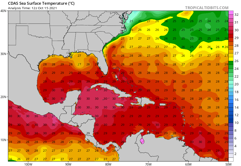
https://i.postimg.cc/8zD2yKMg/cdas-sflux-sst-watl-1.png
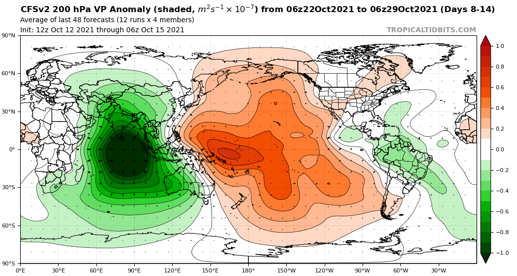
https://i.postimg.cc/FsjtV5fx/cfs-avg-chi200-Mean-global-2.png
Are you laughing that people are skeptical of additional activity? To be fair, it's October 15, late in the peak period, and NHC isn't expecting anything to develop for the next five days. The GFS has been inconsistent, and the ECMWF/EPS remain very quiet. I do think we'll likely see 2-3 more named storms before the season ends, and probably a hurricane. There definitely is a chance for something to form in the Caribbean in late October. However, we have reached the point of the season where strong hurricanes after this point are not an annual occurrence. Some active seasons like 2003, 2004 and 2017 had no hurricanes after this date. I think you are being a bit too bullish, you have been calling for constant hyperactivity all season. This late season clearly isn't a 2020 repeat.
4 likes
NCSU B.S. in Meteorology Class of 2021. Tropical weather blogger at http://www.cyclonicfury.com. My forecasts and thoughts are NOT official, for official forecasts please consult the National Hurricane Center.
-
Spacecoast

- Category 2

- Posts: 687
- Joined: Thu Aug 31, 2017 2:03 pm
Re: 2021 Indicators: SST's / SAL / MSLP / Shear / Steering / Instability / Sat Images
aspen wrote:If somehow nothing develops for the rest of the year, 2021 will finish at 20/7/4/140 ACE, but will have been a strange mix of quantity>quality and high-quality storms.
If one last storm develops and becomes a Nina-fueled WCar beast, 2021 will be a slightly more impressive 21/8/5 year with 145-155 ACE.
Either way, it looks like CSU / Phil K's seasonal forecast of 18 / 8 / 4 will be very close to accurate.
0 likes
Re: 2021 Indicators: SST's / SAL / MSLP / Shear / Steering / Instability / Sat Images
AlphaToOmega wrote:Trololololo
https://i.postimg.cc/8zD2yKMg/cdas-sflux-sst-watl-1.png
https://i.postimg.cc/FsjtV5fx/cfs-avg-chi200-Mean-global-2.png
We’re not getting any big burst in activity like previous MJO passes; it’s too late in the season. However, it does appear that the Atlantic might have just enough juice left over for one final notable system. While the OP/ensembles haven’t been very consistent or active depending on the model like CyclonicFury said, there is still potential for that wave sometime between 7-15 days out. After that, maybe 2021 will just barely get into the auxiliary list with a weak Adria somewhere in the subtropics, but as for land threats (either major or minor), this upcoming wave will probably be the last thing anyone has to worry about.
0 likes
Irene '11 Sandy '12 Hermine '16 5/15/2018 Derecho Fay '20 Isaias '20 Elsa '21 Henri '21 Ida '21
I am only a meteorology enthusiast who knows a decent amount about tropical cyclones. Look to the professional mets, the NHC, or your local weather office for the best information.
I am only a meteorology enthusiast who knows a decent amount about tropical cyclones. Look to the professional mets, the NHC, or your local weather office for the best information.

Re: 2021 Indicators: SST's / SAL / MSLP / Shear / Steering / Instability / Sat Images
Given how 2021 loves to surprise everyone, both in terms of unexpected activity and unexpected inactivity, I have a feeling that the season will put out one(maybe?) last surprise and the upcoming burst will be more substantial than people here expect.
Prepared to eat crow FWIW.
Prepared to eat crow FWIW.
0 likes
-
Category5Kaiju

- Category 5
- Posts: 3349
- Age: 22
- Joined: Thu Dec 24, 2020 12:45 pm
- Location: Seattle
Re: 2021 Indicators: SST's / SAL / MSLP / Shear / Steering / Instability / Sat Images
https://www.accuweather.com/en/hurricane/goodbye-hurricane-season-with-6-weeks-to-go-it-may-be-all-but-over/1033623
At least according to Dan Kottlowski, he seems to still be on board that the Atlantic can still churn up a few storms late season
At least according to Dan Kottlowski, he seems to still be on board that the Atlantic can still churn up a few storms late season
0 likes
Unless explicitly stated, all information covered in my posts is based on my opinions and observations. Please refer to a professional meteorologist or an accredited weather research agency otherwise, especially if serious decisions must be made in the event of a potentially life-threatening tropical storm or hurricane.


Re: 2021 Indicators: SST's / SAL / MSLP / Shear / Steering / Instability / Sat Images
Category5Kaiju wrote:aspen wrote:We’ll probably have a better idea of the season’s ending around the middle of next week. The tropical wave that could become a WCar system will be nearing the Lesser Antilles by then, and any development will fall into the slightly less uncertain 5-7 day range. If that wave is not developing despite the MJO slowly coming into a more favorable position, then the season is done for — it won’t be able to produce anything once the MJO leaves, seeing how activity in the NHem is so dependent on sub-seasonal forcings this year.
Imagine if the WPAC, the EPAC, and the Atlantic collectively fail to generate NSs this month, let alone at least one potent cyclone. That would certainly have nearly every met and weather enthusiast scratching their heads for answers.
Scratching??? I'm past that. My head's been bleeding for 2 weeks already.
6 likes
Personal Forecast Disclaimer:
The posts in this forum are NOT official forecast and should not be used as such. They are just the opinion of the poster and may or may not be backed by sound meteorological data. They are NOT endorsed by any professional institution or storm2k.org. For official information, please refer to the NHC and NWS products.
The posts in this forum are NOT official forecast and should not be used as such. They are just the opinion of the poster and may or may not be backed by sound meteorological data. They are NOT endorsed by any professional institution or storm2k.org. For official information, please refer to the NHC and NWS products.

Re: 2021 Indicators: SST's / SAL / MSLP / Shear / Steering / Instability / Sat Images
September and October really are behaving like 2007 save for the MDR being more favorable.
Gulf: Two Cat 1 hurricanes and a depression in the in 2007, one storm and one Cat 1 in 2021.
Caribbean: 2007 had Cat 5 Felix early in the month and then literally nothing until October 27. This year has gone without a storm in the Caribbean since late August.
Subtropics: Two short lived subtropical storms in 2007 with both transitioning; 2021 similarly only two short-lived subtropical storms, with neither transitioning fully.
MDR: 2007 saw 3/1/0. This was the biggest difference in performance, with 2021 producing 5/2/2.
East Pacific saw two Cat 1 hurricanes and a tropical storm in September and one tropical storm in October, while 2021 had a Cat 2 in September and Cat 1 in October.
Notably, the West Pacific was significantly less active this year than 2007, which may have contributed to Sam and Larry persisting in the manner they did.
It does lead to wondering if the warm pool in the East Pacific likely contributed to the reduction in Caribbean activity by allowing for more shear, given the EPac managed to produce a Cat 2 after August, which wasn't the case in 2007.
1 likes
The above post is not official and should not be used as such. It is the opinion of the poster and may or may not be backed by sound meteorological data. It is not endorsed by any professional institution or storm2k.org. For official information, please refer to the NHC and NWS products.
-
skyline385

- Category 5
- Posts: 2444
- Age: 33
- Joined: Wed Aug 26, 2020 11:15 pm
- Location: Palm Beach County FL
Re: 2021 Indicators: SST's / SAL / MSLP / Shear / Steering / Instability / Sat Images
Both the GFS operational and ensembles seem to suggest tropical waves coming off Africa even heading into November which just seems wrong, does anyone know of a time where the CV systems extended as far as late October or November?
0 likes
-
AlphaToOmega
- Category 5
- Posts: 1448
- Joined: Sat Jun 26, 2021 10:51 am
- Location: Somewhere in Massachusetts
Re: 2021 Indicators: SST's / SAL / MSLP / Shear / Steering / Instability / Sat Images
skyline385 wrote:Both the GFS operational and ensembles seem to suggest tropical waves coming off Africa even heading into November which just seems wrong, does anyone know of a time where the CV systems extended as far as late October or November?
No Cape Verde system has ever formed in November (at least since 1851). However, the Western MDR and the Caribbean are still open for business in November, and the tropical waves, should they develop, would probably develop in the Western MDR or the Caribbean.
0 likes
-
Category5Kaiju
- Category 5
- Posts: 3349
- Age: 22
- Joined: Thu Dec 24, 2020 12:45 pm
- Location: Seattle
Re: 2021 Indicators: SST's / SAL / MSLP / Shear / Steering / Instability / Sat Images
skyline385 wrote:Both the GFS operational and ensembles seem to suggest tropical waves coming off Africa even heading into November which just seems wrong, does anyone know of a time where the CV systems extended as far as late October or November?
I honestly do not have a clue, although there have been examples of notorious hurricanes that developed into a TD in the MDR during that timeframe such as the 1932 Cuba hurricane. Now as for if what the GFS showing is just wrong, it most likely is, although I will say that it would be very interesting to see if something like that does pan out (which, if in the very hypothetical sense it does, would most likely be thanks to the very potent Atlantic Nino this year).
0 likes
Unless explicitly stated, all information covered in my posts is based on my opinions and observations. Please refer to a professional meteorologist or an accredited weather research agency otherwise, especially if serious decisions must be made in the event of a potentially life-threatening tropical storm or hurricane.
-
AlphaToOmega
- Category 5
- Posts: 1448
- Joined: Sat Jun 26, 2021 10:51 am
- Location: Somewhere in Massachusetts
Re: 2021 Global Model Runs Discussion (Out thru day 16)
Hammy wrote:Category5Kaiju wrote:http://tropic.ssec.wisc.edu/real-time/atlantic/winds/wg8shr.GIF
Based on the instantaneous wind shear map in the Atlantic now, one would think that it is quite typical of what would be seen in mid-October in a La Nina year. The ssts are plenty warm, especially in the GoM and the Caribbean. Sahara dust outbreaks are not what you see this time of the year. So that begs the question, is there something else that some of these models are seeing that make them refuse to show activity anytime soon in the Atlantic?
40-50kt shear over the NW Caribbean is not at all typical of La Nina October. It seems the entire upper air pattern is south of where it should be by 5-10 degrees, the bigger question is what's behind this pattern in the first place.
Probably referring to the Gulf of Mexico and MDR pattern rather than the Caribbean pattern
0 likes

Re: 2021 Global Model Runs Discussion (Out thru day 16)
AlphaToOmega wrote:Hammy wrote:Category5Kaiju wrote:http://tropic.ssec.wisc.edu/real-time/atlantic/winds/wg8shr.GIF
Based on the instantaneous wind shear map in the Atlantic now, one would think that it is quite typical of what would be seen in mid-October in a La Nina year. The ssts are plenty warm, especially in the GoM and the Caribbean. Sahara dust outbreaks are not what you see this time of the year. So that begs the question, is there something else that some of these models are seeing that make them refuse to show activity anytime soon in the Atlantic?
40-50kt shear over the NW Caribbean is not at all typical of La Nina October. It seems the entire upper air pattern is south of where it should be by 5-10 degrees, the bigger question is what's behind this pattern in the first place.
Probably referring to the Gulf of Mexico and MDR pattern rather than the Caribbean pattern
There is relatively low shear over central Gulf, and high shear over the W Caribbean, in association with an upper-level trough. Upper level winds will become reestablished over the Gulf following frontal passage and a Caribbean anticyclone is forecast to develop and persist into November.
^ A typical late season pattern in "normal" hurricane seasons. Generally supportive of Caribbean activity (just unlikely to send anything towards the CONUS).
So why are models not developing in lieu of this pattern change? Here are some reasons individual ensemble members do not have development:
- Low latitude tropical waves buried into South America.
- Troughiness over the Caribbean stringing out disturbances.
- Broad monsoonal gyres take an extended period to 'spin up.'
- Waves driven into the Pacific (ridging) and develop there, or driven into the Gulf and sheared out (often into a hybrid low over the SEUS).
I still think it is very likely we see a Caribbean TC in November if not late October.
4 likes
Kendall -> SLO -> PBC
Memorable Storms: Katrina (for its Florida landfall...) Wilma Matthew Irma
Memorable Storms: Katrina (for its Florida landfall...) Wilma Matthew Irma
-
Category5Kaiju
- Category 5
- Posts: 3349
- Age: 22
- Joined: Thu Dec 24, 2020 12:45 pm
- Location: Seattle
Re: 2021 Indicators: SST's / SAL / MSLP / Shear / Steering / Instability / Sat Images
So this is some very recent info (updated yesterday) directly from the CPC Climate Hazards and Benefits website, and here is their take on what we could see going forward soon, quoted verbatim:
"Since the original outlook, a La Nina Advisory was issued, with a forecast 87% chance of La Nina conditions during boreal winter. The intraseasonal perspective from the original forecast remains on track, with the Madden-Julian Oscillation (MJO) likely being further east of where the RMM places it (barely over the West Pacific). This disparity is likely due to the RMM index being biased towards RMM phases 4 and 5 (and away from the Western Hemisphere phases 8 and 1) due to the persistent convective dipole over the Maritime Continent and West Pacific from the building La Nina. Looking at the velocity potential-based MJO index, there is obvious eastward progression of the enhanced convection over the Maritime Continent in recent days, while objective wavenumber-frequency filtering of 200-hPa velocity potential places the enhanced MJO envelope near 150W.
No tropical cyclones (TCs) have formed since the initial outlook, and both the Joint Typhoon Warning Center and the National Hurricane Center are not monitoring any disturbances for possible genesis at present. The MJO state favors increasing TC formation potential over the East Pacific in the near-term, and Caribbean Sea later in the forecast period. The ECMWF model forecasts a pair of atmospheric Kelvin waves to have their suppressed phase cross the East Pacific and Atlantic during Week-2 though, which through destructive interference with the favorable MJO environment may limit TC genesis potential to brief windows. For the East Pacific, that genesis window appears to be late in the week of the 17th, with the moderate confidence for TC formation area along 10N during Week-2 maintained from the initial outlook. In the Atlantic, genesis is possible across the southern Caribbean very late in Week-2 tied to equatorial Rossby wave activity. Moderate confidence for TC formation is added here during Week-2 based on the GEFS perspective, although the ECMWF is further south and instead brings the prospective disturbance into South America. Areas forecast to experience above- or below-normal rainfall over the next two weeks are updated to reflect the latest ensemble guidance from the CFS, GEFS, and ECMWF models."
1 likes
Unless explicitly stated, all information covered in my posts is based on my opinions and observations. Please refer to a professional meteorologist or an accredited weather research agency otherwise, especially if serious decisions must be made in the event of a potentially life-threatening tropical storm or hurricane.
-
Category5Kaiju
- Category 5
- Posts: 3349
- Age: 22
- Joined: Thu Dec 24, 2020 12:45 pm
- Location: Seattle
Re: 2021 Indicators: SST's / SAL / MSLP / Shear / Steering / Instability / Sat Images
https://twitter.com/philklotzbach/status/1449470310932090882
Ok, now this is just weird. Perhaps the root reason why we are seeing with the dead Atlantic, whatever it is, is also causing the WPAC and EPAC to be relative weak and inactive? Something tells me that the MJO progression may not be to entirely blame given if that were the case then all of that rising motion in the WPAC should have been capable of allowing the basin to produce some decent storms and activity (but it did not).
Ok, now this is just weird. Perhaps the root reason why we are seeing with the dead Atlantic, whatever it is, is also causing the WPAC and EPAC to be relative weak and inactive? Something tells me that the MJO progression may not be to entirely blame given if that were the case then all of that rising motion in the WPAC should have been capable of allowing the basin to produce some decent storms and activity (but it did not).
0 likes
Unless explicitly stated, all information covered in my posts is based on my opinions and observations. Please refer to a professional meteorologist or an accredited weather research agency otherwise, especially if serious decisions must be made in the event of a potentially life-threatening tropical storm or hurricane.
-
Iceresistance

- Category 5
- Posts: 8910
- Age: 20
- Joined: Sat Oct 10, 2020 9:45 am
- Location: Tecumseh, OK/Norman, OK
Re: 2021 Indicators: SST's / SAL / MSLP / Shear / Steering / Instability / Sat Images
Category5Kaiju wrote:https://twitter.com/philklotzbach/status/1449470310932090882
Ok, now this is just weird. Perhaps the root reason why we are seeing with the dead Atlantic, whatever it is, is also causing the WPAC and EPAC to be relative weak and inactive? Something tells me that the MJO progression may not be to entirely blame given if that were the case then all of that rising motion in the WPAC should have been capable of allowing the basin to produce some decent storms and activity (but it did not).
More dry air & higher Wind Shear around the world than usual?
0 likes
Bill 2015 & Beta 2020
Winter 2020-2021
All observations are in Tecumseh, OK unless otherwise noted.
Winter posts are focused mainly for Oklahoma & Texas.
Take any of my forecasts with a grain of salt, refer to the NWS, SPC, and NHC for official information
Never say Never with weather! Because ANYTHING is possible!
Winter 2020-2021
All observations are in Tecumseh, OK unless otherwise noted.
Winter posts are focused mainly for Oklahoma & Texas.
Take any of my forecasts with a grain of salt, refer to the NWS, SPC, and NHC for official information
Never say Never with weather! Because ANYTHING is possible!
-
AlphaToOmega
- Category 5
- Posts: 1448
- Joined: Sat Jun 26, 2021 10:51 am
- Location: Somewhere in Massachusetts
Re: 2021 Indicators: SST's / SAL / MSLP / Shear / Steering / Instability / Sat Images
Iceresistance wrote:Category5Kaiju wrote:https://twitter.com/philklotzbach/status/1449470310932090882
Ok, now this is just weird. Perhaps the root reason why we are seeing with the dead Atlantic, whatever it is, is also causing the WPAC and EPAC to be relative weak and inactive? Something tells me that the MJO progression may not be to entirely blame given if that were the case then all of that rising motion in the WPAC should have been capable of allowing the basin to produce some decent storms and activity (but it did not).
More dry air & higher Wind Shear around the world than usual?
It is a combination of conflicting factors: -ENSO and -PDO, which would typically support the Atlantic, but +RMM2, which hinders development in the Atlantic. Once the RMM2 goes into the negatives, the Atlantic will likely see development, especially with -ENSO and -PDO.
0 likes
Who is online
Users browsing this forum: AnnularCane, Hurricaneman, Teban54 and 82 guests