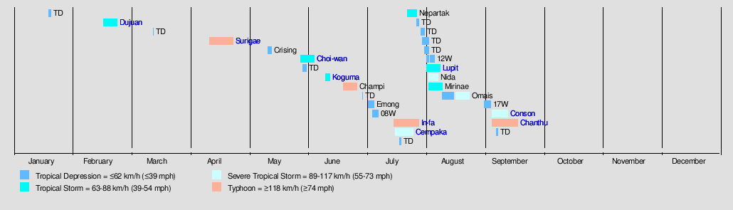
2021 Indicators: SST's / SAL / MSLP / Shear / Steering / Instability / Sat Images

This is the general tropical discussion area. Anyone can take their shot at predicting a storms path.

Moderator: S2k Moderators

Forum rules

The posts in this forum are NOT official forecasts and should not be used as such. They are just the opinion of the poster and may or may not be backed by sound meteorological data. They are NOT endorsed by any professional institution or STORM2K. For official information, please refer to products from the National Hurricane Center and National Weather Service.

Help Support Storm2K
Message
Author
AlphaToOmega
Category 5
Category 5
Posts: 1448
Joined: Sat Jun 26, 2021 10:51 am
Location: Somewhere in Massachusetts

Re: 2021 Indicators: SST's / SAL / MSLP / Shear / Steering / Instability / Sat Images

#3421 Postby AlphaToOmega » Sat Sep 18, 2021 9:47 am

SFLcane wrote:Other then a few weak storms it’s been a lackluster September no doubt. That could always change in October but we’ll see.

Major Hurricane Larry formed this month. I would not say September has been lackluster. By that logic, September 2020 could be considered lackluster.
1 likes   

User avatar
SFLcane
S2K Supporter
S2K Supporter
Posts: 9606
Age: 46
Joined: Sat Jun 05, 2010 1:44 pm
Location: Lake Worth Florida

Re: 2021 Indicators: SST's / SAL / MSLP / Shear / Steering / Instability / Sat Images

#3422 Postby SFLcane » Sat Sep 18, 2021 9:56 am

AlphaToOmega wrote:
SFLcane wrote:Other then a few weak storms it’s been a lackluster September no doubt. That could always change in October but we’ll see.

Major Hurricane Larry formed this month. I would not say September has been lackluster. By that logic, September 2020 could be considered lackluster.


Yea lol forgot about fish food Larry. :sleeping:
1 likes   

AxaltaRacing24
Category 5
Category 5
Posts: 1709
Age: 23
Joined: Wed Jul 27, 2016 11:14 am
Location: Jupiter, FL

Re: 2021 Indicators: SST's / SAL / MSLP / Shear / Steering / Instability / Sat Images

#3423 Postby AxaltaRacing24 » Sat Sep 18, 2021 10:23 am

SFLcane wrote:Other then a few weak storms it’s been a lackluster September no doubt. That could always change in October but we’ll see.

all it takes is 2 more majors, and we’re 1 short of 2017. 3 more, and we are 1 short of the all time record. this season has had its lulls, but the quality department isn’t lacking when you look at the overall totals so far. if october is active, we could end with 5 or 6 majors.
2 likes   

User avatar
Woofde
Category 1
Category 1
Posts: 266
Joined: Tue Jul 06, 2021 11:33 am

Re: RE: Re: 2021 Indicators: SST's / SAL / MSLP / Shear / Steering / Instability / Sat Images

#3424 Postby Woofde » Sat Sep 18, 2021 12:03 pm

Shell Mound wrote:
Weather Dude wrote:
Teban54 wrote:https://twitter.com/philklotzbach/status/1438963130957107203?s=20
Regardless of how you judge the intensity of storms this season, it has really been quite impressive quantity wise.

It really hasn't been that bad quality wise either. Already at 3 majors, so we'll probably end up around 4-5.

Would be nice if those majors wouldn't plow into land though

I respectfully disagree. One would have expected higher ACE during peak season, given -ENSO/-PDO/+IOD/-VE.
ACE is useless at telling how active the season has been considering two of the Majors peaked as they were landfalling. Was Larry really a better indication that this season is active than Ida was?
4 likes   

User avatar
Category5Kaiju
Category 5
Category 5
Posts: 3351
Age: 22
Joined: Thu Dec 24, 2020 12:45 pm
Location: Seattle

Re: RE: Re: 2021 Indicators: SST's / SAL / MSLP / Shear / Steering / Instability / Sat Images

#3425 Postby Category5Kaiju » Sat Sep 18, 2021 12:06 pm

Woofde wrote:
Shell Mound wrote:
Weather Dude wrote:It really hasn't been that bad quality wise either. Already at 3 majors, so we'll probably end up around 4-5.

Would be nice if those majors wouldn't plow into land though

I respectfully disagree. One would have expected higher ACE during peak season, given -ENSO/-PDO/+IOD/-VE.
ACE is useless at telling how active the season has been considering two of the Majors peaked as they were landfalling. Was Larry really a better indication that this season is active than Ida was?


This is why I would love to see a way implemented that measures hurricane season activity with a combination of not only ACE but impact/destruction level. Like an Ida or Michael-like storm would have more of such "points" than say a Larry or Lorenzo-like storm. With that being said, a season like 2008 would be considered much more active than 2010, for example.
0 likes   
Unless explicitly stated, all information covered in my posts is based on my opinions and observations. Please refer to a professional meteorologist or an accredited weather research agency otherwise, especially if serious decisions must be made in the event of a potentially life-threatening tropical storm or hurricane.

User avatar
CyclonicFury
Category 5
Category 5
Posts: 1971
Age: 25
Joined: Sun Jul 02, 2017 12:32 pm
Location: NC
Contact:

Re: 2021 Indicators: SST's / SAL / MSLP / Shear / Steering / Instability / Sat Images

#3426 Postby CyclonicFury » Sat Sep 18, 2021 12:07 pm

ACE is still above average FWIW (current ACE is around 79, mean through this date is around 65).
6 likes   
NCSU B.S. in Meteorology Class of 2021. Tropical weather blogger at http://www.cyclonicfury.com. My forecasts and thoughts are NOT official, for official forecasts please consult the National Hurricane Center.

User avatar
Ubuntwo
Category 5
Category 5
Posts: 1089
Age: 30
Joined: Thu Oct 05, 2017 10:41 pm

Re: RE: Re: 2021 Indicators: SST's / SAL / MSLP / Shear / Steering / Instability / Sat Images

#3427 Postby Ubuntwo » Sat Sep 18, 2021 12:26 pm

Category5Kaiju wrote:
Woofde wrote:ACE is useless at telling how active the season has been considering two of the Majors peaked as they were landfalling. Was Larry really a better indication that this season is active than Ida was?


This is why I would love to see a way implemented that measured hurricane season activity with a combination of not only ACE but impact/destruction level. Like an Ida or Michael-like storm would have more of such "points" than say a Larry or Lorenzo-like storm.

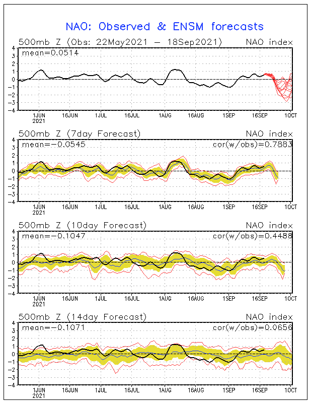
'Destruction' in a season has little to do with overall favorability. Dead years have had huge hits, and hyperactive ones nothing. One could argue RI to landfall is indicative of only a small favorable pocket, vs. a long track major suggesting a vast swath of good conditions. ACE is not perfect but it's the best metric we've got.

To shell mound's point:
Shell Mound wrote:I respectfully disagree. One would have expected higher ACE during peak season, given -ENSO/-PDO/+IOD/-VE.

A suppressive period lined up with climo peak. With the base state there are/were plenty of disturbances, most have just struggled with stability & upper level winds tied to that suppression. Intraseasonal variation is probably the weak link in long-range forecasting.

As many have already suggested, this season is looking like another backloaded one. Maybe more of a bimodal peak.
7 likes   
Kendall -> SLO -> PBC

Memorable Storms: Katrina (for its Florida landfall...) Wilma Matthew Irma

User avatar
gatorcane
S2K Supporter
S2K Supporter
Posts: 23499
Age: 46
Joined: Sun Mar 13, 2005 3:54 pm
Location: Boca Raton, FL

Re: 2021 Indicators: SST's / SAL / MSLP / Shear / Steering / Instability / Sat Images

#3428 Postby gatorcane » Sat Sep 18, 2021 12:41 pm

NDG wrote:And here I was about a week ago thinking that the second half of September was going to be a fairly busy time with threats to the US, didn't see this -NAO coming and neither the long range GEFS and EPS.


Indeed it looks to be tanking:

Image
0 likes   

AlphaToOmega
Category 5
Category 5
Posts: 1448
Joined: Sat Jun 26, 2021 10:51 am
Location: Somewhere in Massachusetts

Re: 2021 Indicators: SST's / SAL / MSLP / Shear / Steering / Instability / Sat Images

#3429 Postby AlphaToOmega » Sat Sep 18, 2021 12:42 pm

gatorcane wrote:
NDG wrote:And here I was about a week ago thinking that the second half of September was going to be a fairly busy time with threats to the US, didn't see this -NAO coming and neither the long range GEFS and EPS.


Indeed it looks to be tanking:

https://i.postimg.cc/Nfx51gKQ/nao-sprd2.gif


That means nothing for October; because most activity from October and beyond will likely be Western Atlantic based, there will likely be land impacts regardless of NAO.
1 likes   

psyclone
S2K Supporter
S2K Supporter
Posts: 4487
Joined: Wed Aug 24, 2005 9:04 pm
Location: palm harbor fl

Re: 2021 Indicators: SST's / SAL / MSLP / Shear / Steering / Instability / Sat Images

#3430 Postby psyclone » Sat Sep 18, 2021 12:49 pm

we have been under seemingly endless gloom here in the east gulf region thanks to Nick and all the other storms this year. The net effect is this cloud cover and rain is sucking the warmth out of the sea...at a time of the year where the sun angle is getting too low to compensate when (if ever) the sun returns. Lot of low to mid 80's sea temps now. Of course this is still plenty warm for a TC, but it is not the dangerous flash fuel we have seen in years past. In fact, I suspect the east gulf is cooler now than it was when Michael transited in October 2018...3 weeks later in the season...it definitely is here locally.
1 likes   

User avatar
Category5Kaiju
Category 5
Category 5
Posts: 3351
Age: 22
Joined: Thu Dec 24, 2020 12:45 pm
Location: Seattle

Re: 2021 Indicators: SST's / SAL / MSLP / Shear / Steering / Instability / Sat Images

#3431 Postby Category5Kaiju » Sat Sep 18, 2021 12:53 pm

The Atlantic so far:
Image

The EPAC so far:
Image

The WPAC so far:
Image

If you may notice, it's quite stunning to see how the Atlantic has already tied or beaten the NS count of both basins. Regardless of ACE, we are doing extremely well with NSs, and honestly if I had to pick which basin of the 3 has been performing the best compared to normal, it would be the Atlantic. With 95L and 97L, more NSs will likely happen soon. Again, to reiterate my point, this is something you do not see every year. Well, aside from 2005 or 2020 from our known record books, that is.
0 likes   
Unless explicitly stated, all information covered in my posts is based on my opinions and observations. Please refer to a professional meteorologist or an accredited weather research agency otherwise, especially if serious decisions must be made in the event of a potentially life-threatening tropical storm or hurricane.

User avatar
Ubuntwo
Category 5
Category 5
Posts: 1089
Age: 30
Joined: Thu Oct 05, 2017 10:41 pm

Re: 2021 Indicators: SST's / SAL / MSLP / Shear / Steering / Instability / Sat Images

#3432 Postby Ubuntwo » Sat Sep 18, 2021 2:44 pm

Category5Kaiju wrote:So I know this should be in the models section and it’s fantasy land, but what if CV season did not end as early as we are used to or know of it ending given recent seasons being more backloaded? The GFS seems to want a bona fide, potent CV storm on its most recent run steered directly toward the islands under a very powerful HP ridge. And this is October 1ish. I mean, we did get Lorenzo as a strong late September CV storm, and Matthew formed before the islands…

MJO Phase 3 generally means stronger waves coming off Africa, without necessarily inducing favorable conditions in the basin. So development should be especially tied to kelvin wave passage. Waves coming off in favorable periods might develop in the MDR and recurve as CV cyclones. And waves coming off in suppressive periods may become sleepers, posing a threat to the western basin.

At least that's my take :P
3 likes   
Kendall -> SLO -> PBC

Memorable Storms: Katrina (for its Florida landfall...) Wilma Matthew Irma

AlphaToOmega
Category 5
Category 5
Posts: 1448
Joined: Sat Jun 26, 2021 10:51 am
Location: Somewhere in Massachusetts

Re: 2021 Indicators: SST's / SAL / MSLP / Shear / Steering / Instability / Sat Images

#3433 Postby AlphaToOmega » Sat Sep 18, 2021 3:31 pm

Image
3 likes   

User avatar
Hammy
Category 5
Category 5
Posts: 5594
Age: 40
Joined: Fri May 25, 2012 5:25 pm
Contact:

Re: 2021 Indicators: SST's / SAL / MSLP / Shear / Steering / Instability / Sat Images

#3434 Postby Hammy » Sat Sep 18, 2021 5:31 pm

Can't help but wonder if we end up hurricane-free the rest of September at this rate. Models seem to just spin up storms and then fizzle the closer it gets.
0 likes   
The above post is not official and should not be used as such. It is the opinion of the poster and may or may not be backed by sound meteorological data. It is not endorsed by any professional institution or storm2k.org. For official information, please refer to the NHC and NWS products.

User avatar
Category5Kaiju
Category 5
Category 5
Posts: 3351
Age: 22
Joined: Thu Dec 24, 2020 12:45 pm
Location: Seattle

Re: 2021 Indicators: SST's / SAL / MSLP / Shear / Steering / Instability / Sat Images

#3435 Postby Category5Kaiju » Sat Sep 18, 2021 5:38 pm

Hammy wrote:Can't help but wonder if we end up hurricane-free the rest of September at this rate. Models seem to just spin up storms and then fizzle the closer it gets.


Last week of September should be interesting, the GFS and CMC have really loved the idea of an MDR storm that is a fish storm but looks to become a hurricane. I can't help but imagine too, although we still have 13 days until the month ends, and 13 days as we have seen various times in the past is a lot of time for things to change in the tropics.
3 likes   
Unless explicitly stated, all information covered in my posts is based on my opinions and observations. Please refer to a professional meteorologist or an accredited weather research agency otherwise, especially if serious decisions must be made in the event of a potentially life-threatening tropical storm or hurricane.

User avatar
aspen
Category 5
Category 5
Posts: 8056
Joined: Sat Oct 12, 2019 7:10 pm
Location: Connecticut, USA

Re: 2021 Indicators: SST's / SAL / MSLP / Shear / Steering / Instability / Sat Images

#3436 Postby aspen » Sat Sep 18, 2021 6:22 pm

Hammy wrote:Can't help but wonder if we end up hurricane-free the rest of September at this rate. Models seem to just spin up storms and then fizzle the closer it gets.

Even if we do get at least one more hurricane this month, whether it be 97L over-achieving or that MDR system the models really want to form this upcoming week, 95L will still be one of the worst model busts in the last few years — unless it finds a way to blow up into a Cat 2-3. Then it wouldn’t be nearly as bad, but still a far cry from what the Euro was showing.
0 likes   
Irene '11 Sandy '12 Hermine '16 5/15/2018 Derecho Fay '20 Isaias '20 Elsa '21 Henri '21 Ida '21

I am only a meteorology enthusiast who knows a decent amount about tropical cyclones. Look to the professional mets, the NHC, or your local weather office for the best information.

AlphaToOmega
Category 5
Category 5
Posts: 1448
Joined: Sat Jun 26, 2021 10:51 am
Location: Somewhere in Massachusetts

Re: 2021 Indicators: SST's / SAL / MSLP / Shear / Steering / Instability / Sat Images

#3437 Postby AlphaToOmega » Sat Sep 18, 2021 8:15 pm

So far, the bearish posts about September are not aging well. This activity is in spite of a suppressive CCKW in the Atlantic. Four storms have formed already, and two more are likely to form next morning. Once a favorable CCKW comes into the Atlantic later this month, we could see a burst of activity then. I guess we have shown that it is very difficult to fight the climatological peak of hurricane season.
1 likes   

User avatar
Ubuntwo
Category 5
Category 5
Posts: 1089
Age: 30
Joined: Thu Oct 05, 2017 10:41 pm

Re: 2021 Indicators: SST's / SAL / MSLP / Shear / Steering / Instability / Sat Images

#3438 Postby Ubuntwo » Sat Sep 18, 2021 9:18 pm

AlphaToOmega wrote:So far, the bearish posts about September are not aging well. This activity is in spite of a suppressive CCKW in the Atlantic. Four storms have formed already, and two more are likely to form next morning. Once a favorable CCKW comes into the Atlantic later this month, we could see a burst of activity then. I guess we have shown that it is very difficult to fight the climatological peak of hurricane season.

Said posts were arguing against a hyperactive September, not an active one. The month is currently average in terms of ACE with no major land threats (we got lucky). With a favorable base state plenty potent disturbances formed. Most have just struggled beyond that.

By the end of sept, monthly ACE could be above average. Major land threats will probably have to wait.
4 likes   
Kendall -> SLO -> PBC

Memorable Storms: Katrina (for its Florida landfall...) Wilma Matthew Irma

tolakram
Admin
Admin
Posts: 19165
Age: 60
Joined: Sun Aug 27, 2006 8:23 pm
Location: Florence, KY (name is Mark)

Re: 2021 Indicators: SST's / SAL / MSLP / Shear / Steering / Instability / Sat Images

#3439 Postby tolakram » Sat Sep 18, 2021 10:02 pm

Ubuntwo wrote:
AlphaToOmega wrote:So far, the bearish posts about September are not aging well. This activity is in spite of a suppressive CCKW in the Atlantic. Four storms have formed already, and two more are likely to form next morning. Once a favorable CCKW comes into the Atlantic later this month, we could see a burst of activity then. I guess we have shown that it is very difficult to fight the climatological peak of hurricane season.

Said posts were arguing against a hyperactive September, not an active one. The month is currently average in terms of ACE with no major land threats (we got lucky). With a favorable base state plenty potent disturbances formed. Most have just struggled beyond that.

By the end of sept, monthly ACE could be above average. Major land threats will probably have to wait.


Yea, I'm a little shocked anyone would consider September to be very active when in fact it's been fairly calm for September. I see we finally have TD 16, let's see how long it lasts.
5 likes   
M a r k
- - - - -
Join us in chat: Storm2K Chatroom Invite. Android and IOS apps also available.

The posts in this forum are NOT official forecasts and should not be used as such. Posts are NOT endorsed by any professional institution or STORM2K.org. For official information and forecasts, please refer to NHC and NWS products.

LarryWx
Category 5
Category 5
Posts: 5698
Joined: Sun Sep 07, 2003 2:04 pm
Location: GA

Re: 2021 Indicators: SST's / SAL / MSLP / Shear / Steering / Instability / Sat Images

#3440 Postby LarryWx » Sun Sep 19, 2021 3:37 am

psyclone wrote:we have been under seemingly endless gloom here in the east gulf region thanks to Nick and all the other storms this year. The net effect is this cloud cover and rain is sucking the warmth out of the sea...at a time of the year where the sun angle is getting too low to compensate when (if ever) the sun returns. Lot of low to mid 80's sea temps now. Of course this is still plenty warm for a TC, but it is not the dangerous flash fuel we have seen in years past. In fact, I suspect the east gulf is cooler now than it was when Michael transited in October 2018...3 weeks later in the season...it definitely is here locally.


Here is the comparison between a few days before Michael and now (careful with the blues as they represent different temps though the greens are the same temp of 29-30 C):

Just before Michael: NE GOM solidly warmer than normal like midsummer..that's why Michael was so powerful even well into October as there was no cooler air that had reached the GOM:
Image

Now:
Image

Indeed, much of the NE GOM, is ~2 F cooler as it averaged 85 then vs 83 now (including Panama City) although this says your area changed little at 84. Key West was 84 then and is now 86.
Last edited by LarryWx on Sun Sep 19, 2021 11:58 am, edited 1 time in total.
3 likes   
Personal Forecast Disclaimer:
The posts in this forum are NOT official forecasts and should not be used as such. They are just the opinion of the poster and may or may not be backed by sound meteorological data. They are NOT endorsed by any professional institution or storm2k.org. For official information, please refer to the NHC and NWS products.


Return to “Talkin' Tropics”

Who is online

Users browsing this forum: AnnularCane, Christiana, Google Adsense [Bot], KirbyDude25, tolakram, zzzh and 62 guests