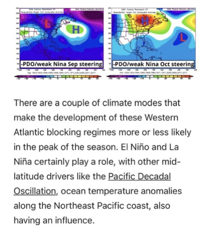
2021 Indicators: SST's / SAL / MSLP / Shear / Steering / Instability / Sat Images

This is the general tropical discussion area. Anyone can take their shot at predicting a storms path.

Moderator: S2k Moderators

Forum rules

The posts in this forum are NOT official forecasts and should not be used as such. They are just the opinion of the poster and may or may not be backed by sound meteorological data. They are NOT endorsed by any professional institution or STORM2K. For official information, please refer to products from the National Hurricane Center and National Weather Service.

Help Support Storm2K
Message
Author
User avatar
SFLcane
S2K Supporter
S2K Supporter
Posts: 9606
Age: 46
Joined: Sat Jun 05, 2010 1:44 pm
Location: Lake Worth Florida

Re: 2021 Indicators: SST's / SAL / MSLP / Shear / Steering / Instability / Sat Images

#3381 Postby SFLcane » Thu Sep 16, 2021 7:48 pm

aspen wrote:
Ubuntwo wrote:EPS does not propagate the MJO. Has several kelvin waves passing across the basin. Verbatim, this would be an active mid-late October following a pause earlier that month.
https://twitter.com/AndyHazelton/status/1438612786385498113

October looks nasty. The western to central Atlantic will be enhanced by -VP anomalies from roughly October 10th through 26th, plenty of time to produce several storms and probably at least one major.


Indeed… should be a cane fest in the Caribbean come October.
2 likes   

User avatar
gatorcane
S2K Supporter
S2K Supporter
Posts: 23499
Age: 46
Joined: Sun Mar 13, 2005 3:54 pm
Location: Boca Raton, FL

Re: 2021 Indicators: SST's / SAL / MSLP / Shear / Steering / Instability / Sat Images

#3382 Postby gatorcane » Thu Sep 16, 2021 8:25 pm

:uarrow: October could get interesting but hoping these indicators bust as bad as they did for those which showed blocking highs and SE Canada ridging to steer Cape Verde storms into Florida and the CONUS during the peak of the season which hasn’t happened.
4 likes   

User avatar
Steve
S2K Supporter
S2K Supporter
Posts: 8605
Joined: Sat Apr 05, 2003 11:41 pm
Location: Not a state-caster

Re: 2021 Indicators: SST's / SAL / MSLP / Shear / Steering / Instability / Sat Images

#3383 Postby Steve » Thu Sep 16, 2021 9:03 pm

gatorcane wrote::uarrow: October could get interesting but hoping these indicators bust as bad as they did for those which showed blocking highs and SE Canada ridging to steer Cape Verde storms into Florida and the CONUS during the peak of the season which hasn’t happened.


?

https://www.weather.gov/oun/sfcmaps

Charts don’t lie. It’s not static but still.
4 likes   

User avatar
toad strangler
S2K Supporter
S2K Supporter
Posts: 4162
Joined: Sun Jul 28, 2013 3:09 pm
Location: Earth
Contact:

Re: 2021 Indicators: SST's / SAL / MSLP / Shear / Steering / Instability / Sat Images

#3384 Postby toad strangler » Thu Sep 16, 2021 9:06 pm

gatorcane wrote::uarrow: October could get interesting but hoping these indicators bust as bad as they did for those which showed blocking highs and SE Canada ridging to steer Cape Verde storms into Florida and the CONUS during the peak of the season which hasn’t happened.


None of this showed steering into FLORIDA specifically. It showed steering that threatened the EAST COAST. Gigantic difference there. Florida is just the southern tip of the East Coast.
But yes, that's been a fail. Anomalous output like that would be suspect every year no matter what. It's easy to ride the climo train. Not so much trying to point out things that could deviate from the beaten trail.
3 likes   

User avatar
Ubuntwo
Category 5
Category 5
Posts: 1089
Age: 30
Joined: Thu Oct 05, 2017 10:41 pm

Re: 2021 Indicators: SST's / SAL / MSLP / Shear / Steering / Instability / Sat Images

#3385 Postby Ubuntwo » Fri Sep 17, 2021 1:23 am

gatorcane wrote::uarrow: October could get interesting but hoping these indicators bust as bad as they did for those which showed blocking highs and SE Canada ridging to steer Cape Verde storms into Florida and the CONUS during the peak of the season which hasn’t happened.

Like Steve said, there is currently a blocking high over SE Canada. 96L opens the trapdoor north, not an upper-latitude trough. Right place at the right time.
5 likes   
Kendall -> SLO -> PBC

Memorable Storms: Katrina (for its Florida landfall...) Wilma Matthew Irma

User avatar
SFLcane
S2K Supporter
S2K Supporter
Posts: 9606
Age: 46
Joined: Sat Jun 05, 2010 1:44 pm
Location: Lake Worth Florida

Re: 2021 Indicators: SST's / SAL / MSLP / Shear / Steering / Instability / Sat Images

#3386 Postby SFLcane » Fri Sep 17, 2021 6:13 am

gatorcane wrote::uarrow: October could get interesting but hoping these indicators bust as bad as they did for those which showed blocking highs and SE Canada ridging to steer Cape Verde storms into Florida and the CONUS during the peak of the season which hasn’t happened.


The worrisome thing though Dr. Ryan predicted this capeverde recurve pattern weeks ago and it panned to the point. Amazing call. See images below from early August.

Image

Image
2 likes   

User avatar
Category5Kaiju
Category 5
Category 5
Posts: 3354
Age: 22
Joined: Thu Dec 24, 2020 12:45 pm
Location: Seattle

Re: 2021 Indicators: SST's / SAL / MSLP / Shear / Steering / Instability / Sat Images

#3387 Postby Category5Kaiju » Fri Sep 17, 2021 6:16 am

So I know this should be in the models section and it’s fantasy land, but what if CV season did not end as early as we are used to or know of it ending given recent seasons being more backloaded? The GFS seems to want a bona fide, potent CV storm on its most recent run steered directly toward the islands under a very powerful HP ridge. And this is October 1ish. I mean, we did get Lorenzo as a strong late September CV storm, and Matthew formed before the islands…
0 likes   
Unless explicitly stated, all information covered in my posts is based on my opinions and observations. Please refer to a professional meteorologist or an accredited weather research agency otherwise, especially if serious decisions must be made in the event of a potentially life-threatening tropical storm or hurricane.

otowntiger
Category 5
Category 5
Posts: 1787
Joined: Tue Aug 31, 2004 7:06 pm
Location: Orlando

Re: 2021 Indicators: SST's / SAL / MSLP / Shear / Steering / Instability / Sat Images

#3388 Postby otowntiger » Fri Sep 17, 2021 7:08 am

gatorcane wrote::uarrow: October could get interesting but hoping these indicators bust as bad as they did for those which showed blocking highs and SE Canada ridging to steer Cape Verde storms into Florida and the CONUS during the peak of the season which hasn’t happened.
yes, my thoughts exactly. It seemed that significant impacts for southeast/ East coast CONUS were a near certainty back then. I for one am glad the dire predictions busted. Here’s hoping the good fortune continues.
0 likes   

zzh
Category 1
Category 1
Posts: 375
Joined: Fri Aug 27, 2021 2:18 pm

Re: 2021 Indicators: SST's / SAL / MSLP / Shear / Steering / Instability / Sat Images

#3389 Postby zzh » Fri Sep 17, 2021 7:30 am

Image
:double:
0 likes   

User avatar
aspen
Category 5
Category 5
Posts: 8056
Joined: Sat Oct 12, 2019 7:10 pm
Location: Connecticut, USA

Re: 2021 Indicators: SST's / SAL / MSLP / Shear / Steering / Instability / Sat Images

#3390 Postby aspen » Fri Sep 17, 2021 8:12 am

It's been a season of wildly varying extremes so far, and with the suppressive MJO phase for late September followed by a likely very enhanced mid-October, that's only going to continue.
Image
16 likes   
Irene '11 Sandy '12 Hermine '16 5/15/2018 Derecho Fay '20 Isaias '20 Elsa '21 Henri '21 Ida '21

I am only a meteorology enthusiast who knows a decent amount about tropical cyclones. Look to the professional mets, the NHC, or your local weather office for the best information.

User avatar
kevin
Category 5
Category 5
Posts: 1767
Age: 25
Joined: Wed Aug 28, 2019 4:35 am

Re: 2021 Indicators: SST's / SAL / MSLP / Shear / Steering / Instability / Sat Images

#3391 Postby kevin » Fri Sep 17, 2021 8:53 am

aspen wrote:It's been a season of wildly varying extremes so far, and with the suppressive MJO phase for late September followed by a likely very enhanced mid-October, that's only going to continue.
https://i.imgur.com/gUlbfP2.png


Haha, nice one. I hope this doesn't mean we get a 'strong dog' again in October. September is usually the most active month, but October (at least that's how it feels to me) is the month where those once-in-a-generation storms form (Wilma, Patrica, Tip, Mitch, Nora etc.).
0 likes   

User avatar
Category5Kaiju
Category 5
Category 5
Posts: 3354
Age: 22
Joined: Thu Dec 24, 2020 12:45 pm
Location: Seattle

Re: 2021 Indicators: SST's / SAL / MSLP / Shear / Steering / Instability / Sat Images

#3392 Postby Category5Kaiju » Fri Sep 17, 2021 9:47 am

Hurricane trackers after September 2021:
Image

Hurricane trackers after October 2021:
Image
8 likes   
Unless explicitly stated, all information covered in my posts is based on my opinions and observations. Please refer to a professional meteorologist or an accredited weather research agency otherwise, especially if serious decisions must be made in the event of a potentially life-threatening tropical storm or hurricane.

User avatar
Category5Kaiju
Category 5
Category 5
Posts: 3354
Age: 22
Joined: Thu Dec 24, 2020 12:45 pm
Location: Seattle

Re: 2021 Indicators: SST's / SAL / MSLP / Shear / Steering / Instability / Sat Images

#3393 Postby Category5Kaiju » Fri Sep 17, 2021 12:42 pm

https://coralreefwatch.noaa.gov/product/5km/index_5km_ssta.php

If this sst anomaly profile signature isn't convincing enough that activity this year's activity could last and be quite potent in October and beyond, then I don't know what is.
0 likes   
Unless explicitly stated, all information covered in my posts is based on my opinions and observations. Please refer to a professional meteorologist or an accredited weather research agency otherwise, especially if serious decisions must be made in the event of a potentially life-threatening tropical storm or hurricane.

User avatar
Teban54
Category 5
Category 5
Posts: 1957
Joined: Sat May 19, 2018 1:19 pm

Re: 2021 Indicators: SST's / SAL / MSLP / Shear / Steering / Instability / Sat Images

#3394 Postby Teban54 » Fri Sep 17, 2021 12:58 pm

Category5Kaiju wrote:https://coralreefwatch.noaa.gov/product/5km/index_5km_ssta.php

If this sst anomaly profile signature isn't convincing enough that activity this year's activity could last and be quite potent in October and beyond, then I don't know what is.

Posting the image here:
Image
Also, here's the SST trend:
Image
SSTs in the Eastern Caribbean continue to rise rapidly, while Western Caribbean and Gulf (aside from Nicholas' cold wake) are also slowly warming. I wonder if the heat in ECar will be transferred to WCar and the Gulf Stream later.

IMO there's a good chance we see a Matthew-like storm that becomes strong in ECar with this setup, rather than the 2020 late-season majors that developed in ECar and reached their peak in WCar.
0 likes   

User avatar
Category5Kaiju
Category 5
Category 5
Posts: 3354
Age: 22
Joined: Thu Dec 24, 2020 12:45 pm
Location: Seattle

Re: 2021 Indicators: SST's / SAL / MSLP / Shear / Steering / Instability / Sat Images

#3395 Postby Category5Kaiju » Fri Sep 17, 2021 1:08 pm

Teban54 wrote:
Category5Kaiju wrote:https://coralreefwatch.noaa.gov/product/5km/index_5km_ssta.php

If this sst anomaly profile signature isn't convincing enough that activity this year's activity could last and be quite potent in October and beyond, then I don't know what is.

Posting the image here:
https://i.imgur.com/TzfUwlT.png
Also, here's the SST trend:
https://i.imgur.com/Rq2yxbA.png
SSTs in the Eastern Caribbean continue to rise rapidly, while Western Caribbean and Gulf (aside from Nicholas' cold wake) are also slowly warming. I wonder if the heat in ECar will be transferred to WCar and the Gulf Stream later.

IMO there's a good chance we see a Matthew-like storm that becomes strong in ECar with this setup, rather than the 2020 late-season majors that developed in ECar and reached their peak in WCar.


Yeah, that is most definitely a concern that I have. In fact, in terms of ACE, while most large ACE producers are strong CV storms that occur earlier, as we saw with storms like the 1915 Louisiana hurricane, 1932 Cuba hurricane, Mitch, or Matthew, you could have a predominantly W Atlantic storm that, if it is able to maintain a ton of strength and move slowly, can generate a lot of ACE points. I just have this feeling that we're going to see at least one of that kind of system later this fall.
0 likes   
Unless explicitly stated, all information covered in my posts is based on my opinions and observations. Please refer to a professional meteorologist or an accredited weather research agency otherwise, especially if serious decisions must be made in the event of a potentially life-threatening tropical storm or hurricane.

AlphaToOmega
Category 5
Category 5
Posts: 1448
Joined: Sat Jun 26, 2021 10:51 am
Location: Somewhere in Massachusetts

Re: 2021 Indicators: SST's / SAL / MSLP / Shear / Steering / Instability / Sat Images

#3396 Postby AlphaToOmega » Fri Sep 17, 2021 3:28 pm

With Tropical Storm Odette forming today, that is a fourth storm for this September. Some more activity is expected between now and September 30.
0 likes   

User avatar
Teban54
Category 5
Category 5
Posts: 1957
Joined: Sat May 19, 2018 1:19 pm

Re: 2021 Indicators: SST's / SAL / MSLP / Shear / Steering / Instability / Sat Images

#3397 Postby Teban54 » Fri Sep 17, 2021 3:47 pm

 https://twitter.com/philklotzbach/status/1438963130957107203


Regardless of how you judge the intensity of storms this season, it has really been quite impressive quantity wise.
0 likes   

User avatar
Category5Kaiju
Category 5
Category 5
Posts: 3354
Age: 22
Joined: Thu Dec 24, 2020 12:45 pm
Location: Seattle

Re: 2021 Indicators: SST's / SAL / MSLP / Shear / Steering / Instability / Sat Images

#3398 Postby Category5Kaiju » Fri Sep 17, 2021 3:54 pm

Well, it looks like regardless of our final total ACE that we are likely going to have a very high NS count in the end. We only need 5 more NSs to tie for third most active season on record, and 7 to hit Adria.
0 likes   
Unless explicitly stated, all information covered in my posts is based on my opinions and observations. Please refer to a professional meteorologist or an accredited weather research agency otherwise, especially if serious decisions must be made in the event of a potentially life-threatening tropical storm or hurricane.

User avatar
ElectricStorm
Category 5
Category 5
Posts: 4526
Age: 23
Joined: Tue Aug 13, 2019 11:23 pm
Location: Skiatook, OK / Norman, OK

Re: 2021 Indicators: SST's / SAL / MSLP / Shear / Steering / Instability / Sat Images

#3399 Postby ElectricStorm » Fri Sep 17, 2021 4:12 pm

Teban54 wrote:https://twitter.com/philklotzbach/status/1438963130957107203?s=20
Regardless of how you judge the intensity of storms this season, it has really been quite impressive quantity wise.

It really hasn't been that bad quality wise either. Already at 3 majors, so we'll probably end up around 4-5.

Would be nice if those majors wouldn't plow into land though
0 likes   
I am in no way a professional. Take what I say with a grain of salt as I could be totally wrong. Please refer to the NHC, NWS, or SPC for official information.

Boomer Sooner!

User avatar
Hammy
Category 5
Category 5
Posts: 5594
Age: 40
Joined: Fri May 25, 2012 5:25 pm
Contact:

Re: 2021 Indicators: SST's / SAL / MSLP / Shear / Steering / Instability / Sat Images

#3400 Postby Hammy » Fri Sep 17, 2021 5:00 pm

CFS performed remarkably well 2-3 months out for September, showing 1-2 long trackers (as we could still have a second) with mostly weaker storms over the open Atlantic (no clue on GoM as the maps consistently wouldn't load)

Interesting that this year is behaving similarly to 2007, another La Nina year, with having a short period of rapidly intensifying storms in the western basin (Dean/Felix and Grace/Ida) and a storm rapidly intensifying to hurricane close to Texas (Humberto/Nicholas) with most of the Atlantic itself featuring shorter-lived, highly sheared systems--with Larry being a glaring difference.

Did 2007 feature similar below-normal global activity?
1 likes   
The above post is not official and should not be used as such. It is the opinion of the poster and may or may not be backed by sound meteorological data. It is not endorsed by any professional institution or storm2k.org. For official information, please refer to the NHC and NWS products.


Return to “Talkin' Tropics”

Who is online

Users browsing this forum: Google Adsense [Bot] and 84 guests