2021 Indicators: SST's / SAL / MSLP / Shear / Steering / Instability / Sat Images

This is the general tropical discussion area. Anyone can take their shot at predicting a storms path.

Moderator: S2k Moderators

Forum rules

The posts in this forum are NOT official forecasts and should not be used as such. They are just the opinion of the poster and may or may not be backed by sound meteorological data. They are NOT endorsed by any professional institution or STORM2K. For official information, please refer to products from the National Hurricane Center and National Weather Service.

Help Support Storm2K
Message
Author
User avatar
WiscoWx02
Category 1
Category 1
Posts: 340
Age: 21
Joined: Sat Jul 31, 2021 8:09 pm
Location: Minnesota

Re: 2021 Indicators: SST's / SAL / MSLP / Shear / Steering / Instability / Sat Images

#3921 Postby WiscoWx02 » Mon Oct 11, 2021 8:55 am

Category5Kaiju wrote:
WiscoWx02 wrote:
toad strangler wrote:
Nobody is ignoring anything. Come on. This place will always be active with a storm in the basin. Please don’t over react to those who are weighing in on their specific area of interest.

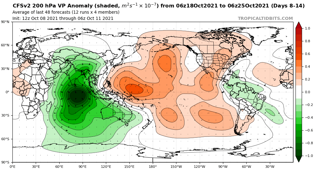
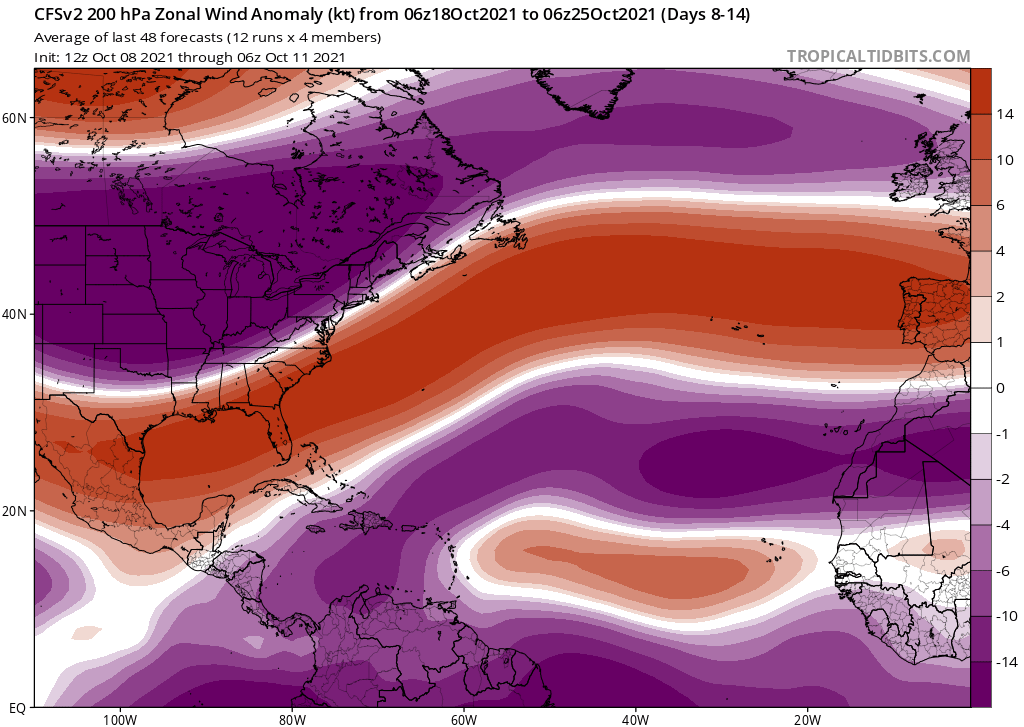
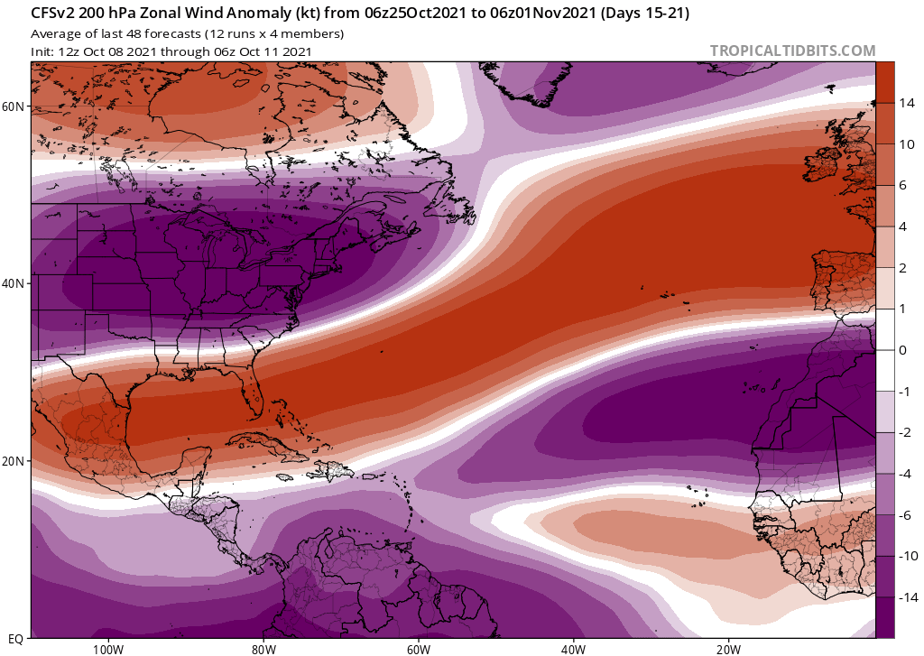
The facts right now are that models are showing what is very likely the end to the season where an overwhelming majority of members reside. That’s what’s on the docket. That season end does NOT mean zero CONUS activity. It's been very well laid out that it's a Cat 1 minimum landfall on up we are talking about.


I have definitely never ignored Central America, that is impossible after last year or Nate (2017), Otto (2016) etc......Although I seriously doubt their going to see any hurricane impacts either at this point for the remainder of the season. Maybe some messy monsoonal gyre stuff that barely takes a name but even that seems a bit of a stretch at this point. In terms of the models, we are done. I don't believe them 100% and still wouldn't be shocked to see one or two more named storms but would would be quite shocked to see a hurricane anywhere in the basin. I don't want to suggest however, that a weak, sloppy storm can't cause a lot of damage in Central America cause they certainly can with all the terrain and landslides and whatnot. But in regards to major hurricanes that some are counting on, the big activity is going to have to weight until next year more likely than not, or maybe even 2023.


I will caution though that the models still do not see out into November, and there have been a handful of La Nina years (1999, 2001, 2008, 2020 as examples) that featured strong hurricanes during then. Not saying it will happen this year, but you may never know (with time being the only solution). Also I feel like given the ENSO state's uncertainty for 2022 and 2023, saying that "major hurricanes that some are counting on, the big activity is going to have to wait until next year more likely than not, or maybe even 2023" is a bit early to say; as you may know predicting ENSO before May or June is really hard to efficiently do


Yeah your 100% right. I'll save that argument for the 2022 thread lol. Speaking of November...I don't have subscriptions to any of those big sites most of you get your model data from, all I have is tropicaltidbits. Is there a way to look back to 2017 and see what models were predicting in terms of the MJO for the October and November time frame of that year? Figure it would be interesting to see.

Edit: Actually, where could I go to get that info since it’s my question after all
0 likes   

User avatar
Category5Kaiju
Category 5
Category 5
Posts: 3352
Age: 22
Joined: Thu Dec 24, 2020 12:45 pm
Location: Seattle

Re: 2021 Indicators: SST's / SAL / MSLP / Shear / Steering / Instability / Sat Images

#3922 Postby Category5Kaiju » Mon Oct 11, 2021 10:05 am

WiscoWx02 wrote:
Category5Kaiju wrote:
WiscoWx02 wrote:
I have definitely never ignored Central America, that is impossible after last year or Nate (2017), Otto (2016) etc......Although I seriously doubt their going to see any hurricane impacts either at this point for the remainder of the season. Maybe some messy monsoonal gyre stuff that barely takes a name but even that seems a bit of a stretch at this point. In terms of the models, we are done. I don't believe them 100% and still wouldn't be shocked to see one or two more named storms but would would be quite shocked to see a hurricane anywhere in the basin. I don't want to suggest however, that a weak, sloppy storm can't cause a lot of damage in Central America cause they certainly can with all the terrain and landslides and whatnot. But in regards to major hurricanes that some are counting on, the big activity is going to have to weight until next year more likely than not, or maybe even 2023.


I will caution though that the models still do not see out into November, and there have been a handful of La Nina years (1999, 2001, 2008, 2020 as examples) that featured strong hurricanes during then. Not saying it will happen this year, but you may never know (with time being the only solution). Also I feel like given the ENSO state's uncertainty for 2022 and 2023, saying that "major hurricanes that some are counting on, the big activity is going to have to wait until next year more likely than not, or maybe even 2023" is a bit early to say; as you may know predicting ENSO before May or June is really hard to efficiently do


Yeah your 100% right. I'll save that argument for the 2022 thread lol. Speaking of November...I don't have subscriptions to any of those big sites most of you get your model data from, all I have is tropicaltidbits. Is there a way to look back to 2017 and see what models were predicting in terms of the MJO for the October and November time frame of that year? Figure it would be interesting to see.

Edit: Actually, where could I go to get that info since it’s my question after all


To be honest I do not have subscriptions to those sites and typically just use Tropical Tidbits (which is free and easy to navigate) as well, but perhaps some of the more longtime and experienced users on this board could have better insight into your question (like maybe wxman57, cycloneye, hammy, or Shell Mound?)
0 likes   
Unless explicitly stated, all information covered in my posts is based on my opinions and observations. Please refer to a professional meteorologist or an accredited weather research agency otherwise, especially if serious decisions must be made in the event of a potentially life-threatening tropical storm or hurricane.

User avatar
CyclonicFury
Category 5
Category 5
Posts: 1973
Age: 25
Joined: Sun Jul 02, 2017 12:32 pm
Location: NC
Contact:

Re: 2021 Indicators: SST's / SAL / MSLP / Shear / Steering / Instability / Sat Images

#3923 Postby CyclonicFury » Mon Oct 11, 2021 1:02 pm

No TCs have formed in the Atlantic yet this month. 2021 is the first year with no Atlantic TCs to form between October 1 and 11 since 2015. With 93L becoming less likely to develop, and the other AOI only having a low chance with minimal model support, the next 7-10 days are likely to be fairly quiet as well. For the Atlantic to not have an unusually quiet October, it's going to have to have a burst of activity when climo is trending less favorable, and I am not completely convinced that will happen. Definitely seems unusually quiet for a -ENSO October, and there's even a recurving storm in the EPAC more typical of El Niño Octobers. Very odd
1 likes   
NCSU B.S. in Meteorology Class of 2021. Tropical weather blogger at http://www.cyclonicfury.com. My forecasts and thoughts are NOT official, for official forecasts please consult the National Hurricane Center.

AlphaToOmega
Category 5
Category 5
Posts: 1448
Joined: Sat Jun 26, 2021 10:51 am
Location: Somewhere in Massachusetts

Re: 2021 Indicators: SST's / SAL / MSLP / Shear / Steering / Instability / Sat Images

#3924 Postby AlphaToOmega » Mon Oct 11, 2021 1:04 pm

CyclonicFury wrote:No TCs have formed in the Atlantic yet this month. 2021 is the first year with no Atlantic TCs to form between October 1 and 11 since 2015. With 93L becoming less likely to develop, and the other AOI only having a low chance with minimal model support, the next 7-10 days are likely to be fairly quiet as well. For the Atlantic to not have an unusually quiet October, it's going to have to have a burst of activity when climo is trending less favorable, and I am not completely convinced that will happen. Definitely seems unusually quiet for a -ENSO October, and there's even a recurving storm in the EPAC more typical of El Niño Octobers. Very odd

Given how CCKWs move west to east, activity in the East Pacific probably means upcoming activity in the Atlantic.
1 likes   

User avatar
Category5Kaiju
Category 5
Category 5
Posts: 3352
Age: 22
Joined: Thu Dec 24, 2020 12:45 pm
Location: Seattle

Re: 2021 Indicators: SST's / SAL / MSLP / Shear / Steering / Instability / Sat Images

#3925 Postby Category5Kaiju » Mon Oct 11, 2021 1:07 pm

CyclonicFury wrote:No TCs have formed in the Atlantic yet this month. 2021 is the first year with no Atlantic TCs to form between October 1 and 11 since 2015. With 93L becoming less likely to develop, and the other AOI only having a low chance with minimal model support, the next 7-10 days are likely to be fairly quiet as well. For the Atlantic to not have an unusually quiet October, it's going to have to have a burst of activity when climo is trending less favorable, and I am not completely convinced that will happen. Definitely seems unusually quiet for a -ENSO October, and there's even a recurving storm in the EPAC more typical of El Niño Octobers. Very odd


What I find especially odd is how models (like the GFS) are not very excited on WPAC and EPAC activity post-Pamela, it’s almost as if they see all three basins inactive for the rest of this month (which I just find incredible and cannot fathom a plausible reason for how it’s even possible)
5 likes   
Unless explicitly stated, all information covered in my posts is based on my opinions and observations. Please refer to a professional meteorologist or an accredited weather research agency otherwise, especially if serious decisions must be made in the event of a potentially life-threatening tropical storm or hurricane.

AlphaToOmega
Category 5
Category 5
Posts: 1448
Joined: Sat Jun 26, 2021 10:51 am
Location: Somewhere in Massachusetts

Re: 2021 Indicators: SST's / SAL / MSLP / Shear / Steering / Instability / Sat Images

#3926 Postby AlphaToOmega » Mon Oct 11, 2021 1:11 pm

Favorable MJO phase coming up soon
Image
4 likes   

User avatar
WiscoWx02
Category 1
Category 1
Posts: 340
Age: 21
Joined: Sat Jul 31, 2021 8:09 pm
Location: Minnesota

Re: 2021 Indicators: SST's / SAL / MSLP / Shear / Steering / Instability / Sat Images

#3927 Postby WiscoWx02 » Mon Oct 11, 2021 1:34 pm

Category5Kaiju wrote:
CyclonicFury wrote:No TCs have formed in the Atlantic yet this month. 2021 is the first year with no Atlantic TCs to form between October 1 and 11 since 2015. With 93L becoming less likely to develop, and the other AOI only having a low chance with minimal model support, the next 7-10 days are likely to be fairly quiet as well. For the Atlantic to not have an unusually quiet October, it's going to have to have a burst of activity when climo is trending less favorable, and I am not completely convinced that will happen. Definitely seems unusually quiet for a -ENSO October, and there's even a recurving storm in the EPAC more typical of El Niño Octobers. Very odd


What I find especially odd is how models (like the GFS) are not very excited on WPAC and EPAC activity post-Pamela, it’s almost as if they see all three basins inactive for the rest of this month (which I just find incredible and cannot fathom a plausible reason for how it’s even possible)


You know what guys, I have been really looking at this all wrong. I have been model hugging which is a no no. Time to be realistic. The MJO is coming sooner or later more likely than not, it may not be this month, heck, it might not be until the end of November, but it is coming and we really should expect at least something in the Caribbean Sea. I doubt it is a US problem or will be, but Central America, especially Nicaragua and Costa Rica need to keep monitoring well into November. You guys have been also presenting more and more historical facts that state 9/10 times the Caribbean Sea sees something in October or November during a La Nina year. Maybe it's a Michelle, a Otto, a Paloma, who knows, but if we do not see anything and my unrealistic downplaying until now actually ends up being right, whoever said extensive research would need to be done on this year if that happened is someone I agree with.

Add on: Yeah! You would think that the GFS would be showing Pacific activity up the wazoo but it's crickets in the medium and long range....perhaps they think a null phase but that doesn't mean Kelvin Waves won't still be out there. Another interesting question is how well does the GFS actually resolve Kelvin Waves. I don't even think the GFS interprets them as existing when you look a the VP anomalies forecast on tropical tidbits for the GFS. It's totally random and doesn't seem to register Kelvin Waves or represent how they truly propagate. Maybe that is the issue?
0 likes   

tolakram
Admin
Admin
Posts: 19165
Age: 60
Joined: Sun Aug 27, 2006 8:23 pm
Location: Florence, KY (name is Mark)

Re: 2021 Indicators: SST's / SAL / MSLP / Shear / Steering / Instability / Sat Images

#3928 Postby tolakram » Mon Oct 11, 2021 2:17 pm

All I know is up here in Cincinnati we're stuck in a summer pattern of high humidity and well above normal temps. This could indicate a delayed October, as far as activity, or not. I've always wondered if stable ENSO is more indicative of activity than transitioning, with neutral actually being the most active.

Regardless, ignore all the charts, I think they are meaningless, including the ones showing favorable conditions. We won't know until this pattern clears or it becomes late enough in the season that it won't matter.

Image
1 likes   
M a r k
- - - - -
Join us in chat: Storm2K Chatroom Invite. Android and IOS apps also available.

The posts in this forum are NOT official forecasts and should not be used as such. Posts are NOT endorsed by any professional institution or STORM2K.org. For official information and forecasts, please refer to NHC and NWS products.

User avatar
Category5Kaiju
Category 5
Category 5
Posts: 3352
Age: 22
Joined: Thu Dec 24, 2020 12:45 pm
Location: Seattle

Re: 2021 Indicators: SST's / SAL / MSLP / Shear / Steering / Instability / Sat Images

#3929 Postby Category5Kaiju » Mon Oct 11, 2021 2:43 pm

So while the Atlantic remains quiet for now, Pamela in the EPAC is currently getting blasted with dry air intrusions with a little bit of unexpectedly high shear as well, and at this point while things can change and she could get her act together, I cannot say that I am as confident that a major, super strong Cat 4/5 hurricane will indeed hit Mexico as anticipated by the models several days or so ago. So what's the significance of this? Well, it just shows how the baseline conditions in the EPAC have not been very kind to storms and have caused them to underperform in numerous occasions this year, and with the solid La Nina look to the EPAC now I cannot say that this kind of event is all that stunning. Imho, the Atlantic is very likely going to see at least a few NSs before the season's end, and if Pamela does indeed end up underperforming up until landfall, then that may given some reason to believe that with an EPAC that is not defying odds and generating powerful storms in a moderate La Nina in October, that the Atlantic will not defy odds and eventually churn up a late season major or two as climo and thermodynamics would suggest as a likely outcome.
1 likes   
Unless explicitly stated, all information covered in my posts is based on my opinions and observations. Please refer to a professional meteorologist or an accredited weather research agency otherwise, especially if serious decisions must be made in the event of a potentially life-threatening tropical storm or hurricane.

User avatar
Ubuntwo
Category 5
Category 5
Posts: 1089
Age: 30
Joined: Thu Oct 05, 2017 10:41 pm

Re: 2021 Indicators: SST's / SAL / MSLP / Shear / Steering / Instability / Sat Images

#3930 Postby Ubuntwo » Mon Oct 11, 2021 2:52 pm

WiscoWx02 wrote:You know what guys, I have been really looking at this all wrong. I have been model hugging which is a no no. Time to be realistic. The MJO is coming sooner or later more likely than not, it may not be this month, heck, it might not be until the end of November, but it is coming and we really should expect at least something in the Caribbean Sea. I doubt it is a US problem or will be, but Central America, especially Nicaragua and Costa Rica need to keep monitoring well into November. You guys have been also presenting more and more historical facts that state 9/10 times the Caribbean Sea sees something in October or November during a La Nina year. Maybe it's a Michelle, a Otto, a Paloma, who knows, but if we do not see anything and my unrealistic downplaying until now actually ends up being right, whoever said extensive research would need to be done on this year if that happened is someone I agree with.

Add on: Yeah! You would think that the GFS would be showing Pacific activity up the wazoo but it's crickets in the medium and long range....perhaps they think a null phase but that doesn't mean Kelvin Waves won't still be out there. Another interesting question is how well does the GFS actually resolve Kelvin Waves. I don't even think the GFS interprets them as existing when you look a the VP anomalies forecast on tropical tidbits for the GFS. It's totally random and doesn't seem to register Kelvin Waves or represent how they truly propagate. Maybe that is the issue?

The GFS can resolve Kelvin waves just fine. Kelvin wave activity is sorta null in the Atlantic right now, but mid-late October will see the passage of a suppressive CCKW which IMO is why models are not enthusiastic on any development. By the end of the month into early November there will be some amplification, and the MJO could be in phase. That’s really late for hurricane CONUS hits so it is easy to see why many are moving on.
2 likes   
Kendall -> SLO -> PBC

Memorable Storms: Katrina (for its Florida landfall...) Wilma Matthew Irma

User avatar
Hammy
Category 5
Category 5
Posts: 5594
Age: 40
Joined: Fri May 25, 2012 5:25 pm
Contact:

Re: 2021 Indicators: SST's / SAL / MSLP / Shear / Steering / Instability / Sat Images

#3931 Postby Hammy » Mon Oct 11, 2021 3:37 pm

Image

Image

CFS trending away from development, and now we see why. Wouldn't surprise me if we have to look to the subtropics (or potentially MDR) for development the rest of the season.
0 likes   
The above post is not official and should not be used as such. It is the opinion of the poster and may or may not be backed by sound meteorological data. It is not endorsed by any professional institution or storm2k.org. For official information, please refer to the NHC and NWS products.

AlphaToOmega
Category 5
Category 5
Posts: 1448
Joined: Sat Jun 26, 2021 10:51 am
Location: Somewhere in Massachusetts

Re: 2021 Indicators: SST's / SAL / MSLP / Shear / Steering / Instability / Sat Images

#3932 Postby AlphaToOmega » Mon Oct 11, 2021 3:43 pm

Hammy wrote:https://i.imgur.com/SqceY5c.png

https://i.imgur.com/w8BuL6M.png

CFS trending away from development, and now we see why. Wouldn't surprise me if we have to look to the subtropics (or potentially MDR) for development the rest of the season.


The October 25 to November 1 VP anomaly map seems like one that would favor the Atlantic, though.
0 likes   

User avatar
CyclonicFury
Category 5
Category 5
Posts: 1973
Age: 25
Joined: Sun Jul 02, 2017 12:32 pm
Location: NC
Contact:

Re: 2021 Indicators: SST's / SAL / MSLP / Shear / Steering / Instability / Sat Images

#3933 Postby CyclonicFury » Mon Oct 11, 2021 3:47 pm

AlphaToOmega wrote:
Hammy wrote:https://i.imgur.com/SqceY5c.png

https://i.imgur.com/w8BuL6M.png

CFS trending away from development, and now we see why. Wouldn't surprise me if we have to look to the subtropics (or potentially MDR) for development the rest of the season.


The October 25 to November 1 VP anomaly map seems like one that would favor the Atlantic, though.

Velocity potential anomalies are just one piece of the puzzle. We're getting later and later into the season where climatology becomes much less favorable. During that timeframe the CFS seems to show a strong jet over the Gulf of Mexico and western Atlantic, which would likely reduce the chances of a U.S. threat should something develop in the Caribbean. The later we get into the season, the less likely a favorable -VP pattern is to produce a burst of activity. I still expect to see about 2-3 more named storms before the end of the season, but nothing like last October/November.
4 likes   
NCSU B.S. in Meteorology Class of 2021. Tropical weather blogger at http://www.cyclonicfury.com. My forecasts and thoughts are NOT official, for official forecasts please consult the National Hurricane Center.

AlphaToOmega
Category 5
Category 5
Posts: 1448
Joined: Sat Jun 26, 2021 10:51 am
Location: Somewhere in Massachusetts

Re: 2021 Indicators: SST's / SAL / MSLP / Shear / Steering / Instability / Sat Images

#3934 Postby AlphaToOmega » Mon Oct 11, 2021 4:50 pm

October of 2020 seemed to have pretty high wind shear across the Atlantic (1 meter per second = 1.94 knots):
Image
0 likes   

User avatar
CyclonicFury
Category 5
Category 5
Posts: 1973
Age: 25
Joined: Sun Jul 02, 2017 12:32 pm
Location: NC
Contact:

Re: 2021 Indicators: SST's / SAL / MSLP / Shear / Steering / Instability / Sat Images

#3935 Postby CyclonicFury » Mon Oct 11, 2021 5:05 pm

AlphaToOmega wrote:October of 2020 seemed to have pretty high wind shear across the Atlantic (1 meter per second = 1.94 knots):
https://i.postimg.cc/T3Y9zX6Y/compday-ustku-Kx-M1-P.gif

It was well below normal across the Caribbean and Gulf though, at least based on the climatology period used:
Image

Thus far this month, wind shear has been much greater than average over the Caribbean and Gulf of Mexico.
Image

This is likely primarily a result of intraseasonal variation and should decrease a bit later in the month. There have also been Octobers (like 2007 and 2019) which had fairly low shear but did not have any significant hurricanes, as well as Octobers with fairly high shear that had significant activity (like 2018). It's important to remember that the October/November we saw last year was very anomalous (5 major hurricanes after October 1, when the previous record was only 2).
9 likes   
NCSU B.S. in Meteorology Class of 2021. Tropical weather blogger at http://www.cyclonicfury.com. My forecasts and thoughts are NOT official, for official forecasts please consult the National Hurricane Center.

User avatar
InfernoFlameCat
Category 5
Category 5
Posts: 1966
Age: 21
Joined: Mon Dec 14, 2020 10:52 am
Location: Buford, GA

Re: 2021 Indicators: SST's / SAL / MSLP / Shear / Steering / Instability / Sat Images

#3936 Postby InfernoFlameCat » Mon Oct 11, 2021 5:07 pm

CyclonicFury wrote:
AlphaToOmega wrote:October of 2020 seemed to have pretty high wind shear across the Atlantic (1 meter per second = 1.94 knots):
https://i.postimg.cc/T3Y9zX6Y/compday-ustku-Kx-M1-P.gif

It was well below normal across the Caribbean and Gulf though, at least based on the climatology period used:
https://i.imgur.com/n3sZD98_d.webp?maxwidth=640&shape=thumb&fidelity=medium

Thus far this month, wind shear has been much greater than average over the Caribbean and Gulf of Mexico.
https://i.imgur.com/cJVJWpj_d.webp?maxwidth=640&shape=thumb&fidelity=medium

This is likely primarily a result of intraseasonal variation and should decrease a bit later in the month. There have also been Octobers (like 2007 and 2019) which had fairly low shear but did not have any significant hurricanes, as well as Octobers with fairly high shear that had significant activity (like 2018). It's important to remember that the October/November we saw last year was very anomalous (5 major hurricanes after October 1, when the previous record was only 2).

October 2020 put September 2020 to shame. 2021 does not look like a repeat IMO.
1 likes   
I am by no means a professional. DO NOT look at my forecasts for official information or make decisions based on what I post.

Goal: to become a registered expert over tropical and subtropical cyclones.

User avatar
CyclonicFury
Category 5
Category 5
Posts: 1973
Age: 25
Joined: Sun Jul 02, 2017 12:32 pm
Location: NC
Contact:

Re: 2021 Indicators: SST's / SAL / MSLP / Shear / Steering / Instability / Sat Images

#3937 Postby CyclonicFury » Mon Oct 11, 2021 5:07 pm

InfernoFlameCat wrote:
CyclonicFury wrote:
AlphaToOmega wrote:October of 2020 seemed to have pretty high wind shear across the Atlantic (1 meter per second = 1.94 knots):
https://i.postimg.cc/T3Y9zX6Y/compday-ustku-Kx-M1-P.gif

It was well below normal across the Caribbean and Gulf though, at least based on the climatology period used:
https://i.imgur.com/n3sZD98_d.webp?maxwidth=640&shape=thumb&fidelity=medium

Thus far this month, wind shear has been much greater than average over the Caribbean and Gulf of Mexico.
https://i.imgur.com/cJVJWpj_d.webp?maxwidth=640&shape=thumb&fidelity=medium

This is likely primarily a result of intraseasonal variation and should decrease a bit later in the month. There have also been Octobers (like 2007 and 2019) which had fairly low shear but did not have any significant hurricanes, as well as Octobers with fairly high shear that had significant activity (like 2018). It's important to remember that the October/November we saw last year was very anomalous (5 major hurricanes after October 1, when the previous record was only 2).

October 2020 put September 2020 to shame. 2021 does not look like a repeat IMO.

I agree, last October was crazy. This October looks much more "normal" even if it is quieter than recent years.
5 likes   
NCSU B.S. in Meteorology Class of 2021. Tropical weather blogger at http://www.cyclonicfury.com. My forecasts and thoughts are NOT official, for official forecasts please consult the National Hurricane Center.

User avatar
Hammy
Category 5
Category 5
Posts: 5594
Age: 40
Joined: Fri May 25, 2012 5:25 pm
Contact:

Re: 2021 Indicators: SST's / SAL / MSLP / Shear / Steering / Instability / Sat Images

#3938 Postby Hammy » Mon Oct 11, 2021 5:15 pm

AlphaToOmega wrote:October of 2020 seemed to have pretty high wind shear across the Atlantic (1 meter per second = 1.94 knots):
https://i.postimg.cc/T3Y9zX6Y/compday-ustku-Kx-M1-P.gif


Worth noting that there was little shear over the NW Caribbean, where most of last October's storms originated.
0 likes   
The above post is not official and should not be used as such. It is the opinion of the poster and may or may not be backed by sound meteorological data. It is not endorsed by any professional institution or storm2k.org. For official information, please refer to the NHC and NWS products.

User avatar
aspen
Category 5
Category 5
Posts: 8056
Joined: Sat Oct 12, 2019 7:10 pm
Location: Connecticut, USA

Re: 2021 Indicators: SST's / SAL / MSLP / Shear / Steering / Instability / Sat Images

#3939 Postby aspen » Mon Oct 11, 2021 6:06 pm

Seeing how Pamela is set to become one of the biggest under-achievers in recent years despite a favorable CCKW and some highly favorable environmental factors (extremely high SSTs and good outflow) shows that the EPac’s base state is still garbage due to the -ENSO, and it gives some hope for the Atlantic to do something cool — hopefully OTS.
2 likes   
Irene '11 Sandy '12 Hermine '16 5/15/2018 Derecho Fay '20 Isaias '20 Elsa '21 Henri '21 Ida '21

I am only a meteorology enthusiast who knows a decent amount about tropical cyclones. Look to the professional mets, the NHC, or your local weather office for the best information.

AlphaToOmega
Category 5
Category 5
Posts: 1448
Joined: Sat Jun 26, 2021 10:51 am
Location: Somewhere in Massachusetts

Re: 2021 Indicators: SST's / SAL / MSLP / Shear / Steering / Instability / Sat Images

#3940 Postby AlphaToOmega » Mon Oct 11, 2021 6:07 pm

Image
Image
1 likes   


Return to “Talkin' Tropics”

Who is online

Users browsing this forum: cycloneye, Google Adsense [Bot], KirbyDude25, NotSparta, TheAustinMan, tolakram and 88 guests