2021 Global Model Runs Discussion (Out thru day 16)
Moderator: S2k Moderators
Forum rules

The posts in this forum are NOT official forecasts and should not be used as such. They are just the opinion of the poster and may or may not be backed by sound meteorological data. They are NOT endorsed by any professional institution or STORM2K. For official information, please refer to products from the National Hurricane Center and National Weather Service.

Re: 2021 Global Model Runs Discussion (Out thru day 16)
These two possible Caribbean systems remind me of Gamma and Delta: consecutive WCar systems with one forming very close to the Yucatán before making landfall, then a second forming in the central Caribbean from an AEW and moving into the WCar after the first system.
0 likes
Irene '11 Sandy '12 Hermine '16 5/15/2018 Derecho Fay '20 Isaias '20 Elsa '21 Henri '21 Ida '21
I am only a meteorology enthusiast who knows a decent amount about tropical cyclones. Look to the professional mets, the NHC, or your local weather office for the best information.
I am only a meteorology enthusiast who knows a decent amount about tropical cyclones. Look to the professional mets, the NHC, or your local weather office for the best information.
-
gatorcane

- S2K Supporter

- Posts: 23499
- Age: 46
- Joined: Sun Mar 13, 2005 3:54 pm
- Location: Boca Raton, FL
Re: 2021 Global Model Runs Discussion (Out thru day 16)
SFLcane wrote:18z Gefs did increase though…
Saved loop, getting more active:
2 likes
-
SFLcane

- S2K Supporter
- Posts: 9606
- Age: 46
- Joined: Sat Jun 05, 2010 1:44 pm
- Location: Lake Worth Florida
Re: 2021 Global Model Runs Discussion (Out thru day 16)
Something is potentially coming to SFL whether it’s some rain or a Cat 1 hurricane which seems to be the ceiling here who knows.
Again gfs is solo here
Again gfs is solo here
0 likes
-
SFLcane
- S2K Supporter
- Posts: 9606
- Age: 46
- Joined: Sat Jun 05, 2010 1:44 pm
- Location: Lake Worth Florida
Re: 2021 Global Model Runs Discussion (Out thru day 16)
Could form in 5-6 days “ IF “ the Gefs and gfs are right which again I remain very skeptical.
0 likes
Re: 2021 Global Model Runs Discussion (Out thru day 16)
If both systems remains on the ensembles or operational models or both by this time Friday, and the time frames haven’t shifted to later in the month, it’ll probably be safe to say that at least one of them isn’t a phantom. Or maybe both do attempt to develop, but the first one remains too close to land and fails to become a TC.
0 likes
Irene '11 Sandy '12 Hermine '16 5/15/2018 Derecho Fay '20 Isaias '20 Elsa '21 Henri '21 Ida '21
I am only a meteorology enthusiast who knows a decent amount about tropical cyclones. Look to the professional mets, the NHC, or your local weather office for the best information.
I am only a meteorology enthusiast who knows a decent amount about tropical cyclones. Look to the professional mets, the NHC, or your local weather office for the best information.

Re: 2021 Global Model Runs Discussion (Out thru day 16)
Getting married in islamorada next Saturday 
Reschedule from 2020
Reschedule from 2020
1 likes
-
skyline385

- Category 5

- Posts: 2444
- Age: 33
- Joined: Wed Aug 26, 2020 11:15 pm
- Location: Palm Beach County FL
2021 Global Model Runs Discussion (Out thru day 16)
SFLcane wrote:Something is potentially coming to SFL whether it’s some rain or a Cat 1 hurricane which seems to be the ceiling here who knows.
Again gfs is solo here
https://i.postimg.cc/hP4YdbGs/5-F38-FE3 ... F0-CAB.jpg
Doesn't GFS still have the ghost CAG system issue? Also there still aren't many ensemble members showing it and i think a majority seem to dodge SFL
0 likes
Re: 2021 Global Model Runs Discussion (Out thru day 16)
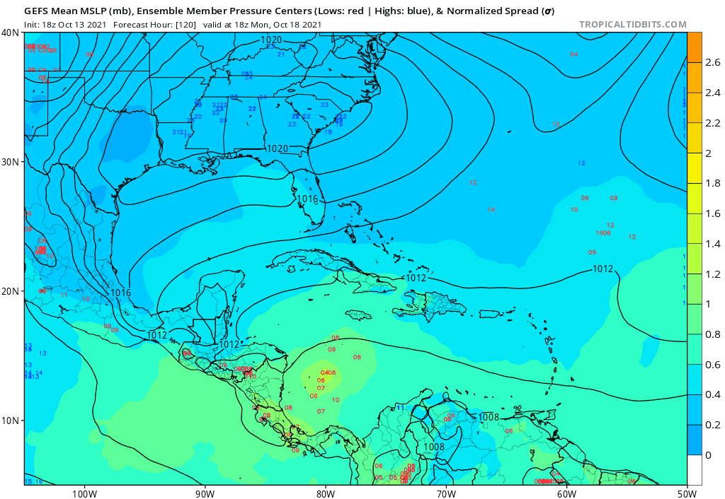
0Z GEFS still has a moderate signal for a potential W Caribbean genesis mid to late next week that then heads NE.
1 likes
Personal Forecast Disclaimer:
The posts in this forum are NOT official forecasts and should not be used as such. They are just the opinion of the poster and may or may not be backed by sound meteorological data. They are NOT endorsed by any professional institution or storm2k.org. For official information, please refer to the NHC and NWS products.
The posts in this forum are NOT official forecasts and should not be used as such. They are just the opinion of the poster and may or may not be backed by sound meteorological data. They are NOT endorsed by any professional institution or storm2k.org. For official information, please refer to the NHC and NWS products.
Re: 2021 Global Model Runs Discussion (Out thru day 16)
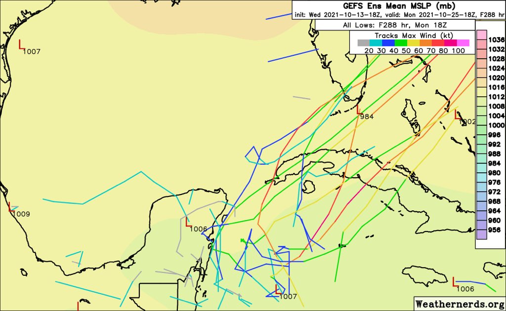
00z GFS has even more EPac bias, with two TCs consolidating on the Pacific side of Central America. This solution can be tossed out.
The precursor wave to the second Caribbean system is quite strong on the 06z GFS, but it gets very close to South America and the GFS finds a way to rip it apart after 240hrs. The time frame remains constant (Oct22-23), however.
The precursor wave to the second Caribbean system is quite strong on the 06z GFS, but it gets very close to South America and the GFS finds a way to rip it apart after 240hrs. The time frame remains constant (Oct22-23), however.
0 likes
Irene '11 Sandy '12 Hermine '16 5/15/2018 Derecho Fay '20 Isaias '20 Elsa '21 Henri '21 Ida '21
I am only a meteorology enthusiast who knows a decent amount about tropical cyclones. Look to the professional mets, the NHC, or your local weather office for the best information.
I am only a meteorology enthusiast who knows a decent amount about tropical cyclones. Look to the professional mets, the NHC, or your local weather office for the best information.
-
SFLcane
- S2K Supporter
- Posts: 9606
- Age: 46
- Joined: Sat Jun 05, 2010 1:44 pm
- Location: Lake Worth Florida
Re: 2021 Global Model Runs Discussion (Out thru day 16)
Inconsistency with the gfs continues quite honestly I am not onboard with anything developing yet let alone it’s the only model with this idea.
0 likes
-
Blown Away

- S2K Supporter
- Posts: 9861
- Joined: Wed May 26, 2004 6:17 am
Re: 2021 Global Model Runs Discussion (Out thru day 16)

06z GEFS... Still showing some activity, one Major skimming SFL...
0 likes
Hurricane Eye Experience: David 79, Irene 99, Frances 04, Jeanne 04, Wilma 05...
Hurricane Brush Experience: Andrew 92, Erin 95, Floyd 99, Matthew 16, Irma 17, Ian 22, Nicole 22…
Hurricane Brush Experience: Andrew 92, Erin 95, Floyd 99, Matthew 16, Irma 17, Ian 22, Nicole 22…
-
Category5Kaiju

- Category 5
- Posts: 3351
- Age: 22
- Joined: Thu Dec 24, 2020 12:45 pm
- Location: Seattle
Re: 2021 Global Model Runs Discussion (Out thru day 16)
Subject to change of course, but some of the long range GEFS ensemble members with that very powerful WCAR system zeroing in on Cuba and originating in the MDR kind of remind me of the 1932 Cuba Hurricane, especially with regards to track and time of year.
0 likes
Unless explicitly stated, all information covered in my posts is based on my opinions and observations. Please refer to a professional meteorologist or an accredited weather research agency otherwise, especially if serious decisions must be made in the event of a potentially life-threatening tropical storm or hurricane.
-
SFLcane
- S2K Supporter
- Posts: 9606
- Age: 46
- Joined: Sat Jun 05, 2010 1:44 pm
- Location: Lake Worth Florida
Re: 2021 Global Model Runs Discussion (Out thru day 16)
GFS definitely backing off any development. Looks like your typical Caribbean convective bias.
0 likes
-
Category5Kaiju
- Category 5
- Posts: 3351
- Age: 22
- Joined: Thu Dec 24, 2020 12:45 pm
- Location: Seattle
Re: 2021 Global Model Runs Discussion (Out thru day 16)
SFLcane wrote:GFS definitely backing off any development. Looks like your typical Caribbean convective bias.
Yeah well it’s also spinning a detectable vorticity right off the Central American coast on the EPAC side, so I’m pretty sure there’s some convective EPAC bias going on here though. GFS otherwise has been consistent with the general idea that a gyre or broad area of spin would set up around next week, I personally do not think that has changed
2 likes
Unless explicitly stated, all information covered in my posts is based on my opinions and observations. Please refer to a professional meteorologist or an accredited weather research agency otherwise, especially if serious decisions must be made in the event of a potentially life-threatening tropical storm or hurricane.
-
CourierPR

- Category 5
- Posts: 1325
- Age: 70
- Joined: Tue Aug 31, 2004 7:53 pm
- Location: Pompano Beach, Florida
Re: 2021 Global Model Runs Discussion (Out thru day 16)
Here is a very recent tweet by Meteorologist Joe Bastardi.
"the 3 month period we are is inthe most active 90 days of the year. to see a complete shutdown in mid October is extreme, Pacifc basins well below ave this year I do not believe we are done in the atlantic. JMA VV and week 2 precip indicate carribean Fla/Bahamas place to watch"
"the 3 month period we are is inthe most active 90 days of the year. to see a complete shutdown in mid October is extreme, Pacifc basins well below ave this year I do not believe we are done in the atlantic. JMA VV and week 2 precip indicate carribean Fla/Bahamas place to watch"
0 likes
Re: 2021 Global Model Runs Discussion (Out thru day 16)
The GFS continues to show the precursor wave next weekend, but still tries to shut down the Atlantic and develop at least one TC on the EPac side of Central America. Clearly it’s suffering from severe bias. We’re now officially in a La Niña atmosphere so any EPac development is next to impossible.
1 likes
Irene '11 Sandy '12 Hermine '16 5/15/2018 Derecho Fay '20 Isaias '20 Elsa '21 Henri '21 Ida '21
I am only a meteorology enthusiast who knows a decent amount about tropical cyclones. Look to the professional mets, the NHC, or your local weather office for the best information.
I am only a meteorology enthusiast who knows a decent amount about tropical cyclones. Look to the professional mets, the NHC, or your local weather office for the best information.

Re: 2021 Global Model Runs Discussion (Out thru day 16)
aspen wrote:The GFS continues to show the precursor wave next weekend, but still tries to shut down the Atlantic and develop at least one TC on the EPac side ofCentral America. Clearly it’s suffering from severe bias. We’re now officially in a La Niña atmosphere so any EPac development is next to impossible.
Not really sure it can be tied to a bias. The past few runs have had stronger ridging driving the wave into Central America and the Pacific. Even without development Pacific side, that would limit Atlantic development. The euro has a similar progression.
0 likes
Kendall -> SLO -> PBC
Memorable Storms: Katrina (for its Florida landfall...) Wilma Matthew Irma
Memorable Storms: Katrina (for its Florida landfall...) Wilma Matthew Irma
-
Category5Kaiju
- Category 5
- Posts: 3351
- Age: 22
- Joined: Thu Dec 24, 2020 12:45 pm
- Location: Seattle
Re: 2021 Global Model Runs Discussion (Out thru day 16)
Ubuntwo wrote:aspen wrote:The GFS continues to show the precursor wave next weekend, but still tries to shut down the Atlantic and develop at least one TC on the EPac side ofCentral America. Clearly it’s suffering from severe bias. We’re now officially in a La Niña atmosphere so any EPac development is next to impossible.
Not really sure it can be tied to a bias. The past few runs have had stronger ridging driving the wave into Central America and the Pacific. Even without development Pacific side, that would limit Atlantic development. The euro has a similar progression.
But that is precisely the issue though, the GFS has a robustly strengthening EPAC system next week or so merely miles off the west coast of Guatemala and Mexico. I personally find this to not be realistic
0 likes
Unless explicitly stated, all information covered in my posts is based on my opinions and observations. Please refer to a professional meteorologist or an accredited weather research agency otherwise, especially if serious decisions must be made in the event of a potentially life-threatening tropical storm or hurricane.
Re: 2021 Global Model Runs Discussion (Out thru day 16)
The wave won’t reach the Lesser Antilles for another 8-10 days. We’ve got plenty of time to watch this. It could get shoved too far south, or the models could trend to weaker ridging and a developing storm. If we do get a TC from this wave, it might not be until the last week of the month.
0 likes
Irene '11 Sandy '12 Hermine '16 5/15/2018 Derecho Fay '20 Isaias '20 Elsa '21 Henri '21 Ida '21
I am only a meteorology enthusiast who knows a decent amount about tropical cyclones. Look to the professional mets, the NHC, or your local weather office for the best information.
I am only a meteorology enthusiast who knows a decent amount about tropical cyclones. Look to the professional mets, the NHC, or your local weather office for the best information.
Re: 2021 Global Model Runs Discussion (Out thru day 16)
Category5Kaiju wrote:But that is precisely the issue though, the GFS has a robustly strengthening EPAC system next week or so merely miles off the west coast of Guatemala and Mexico. I personally find this to not be realistic
From the same wave earlier runs developed in the Western Caribbean. The wave only ends up in the Pacific stronger ridging is modeled. Hard for a wave outside tbe basin to develop Atlantic side
Last edited by Ubuntwo on Thu Oct 14, 2021 12:03 pm, edited 1 time in total.
0 likes
Kendall -> SLO -> PBC
Memorable Storms: Katrina (for its Florida landfall...) Wilma Matthew Irma
Memorable Storms: Katrina (for its Florida landfall...) Wilma Matthew Irma
Who is online
Users browsing this forum: CFLHurricane, USTropics, zzzh and 93 guests