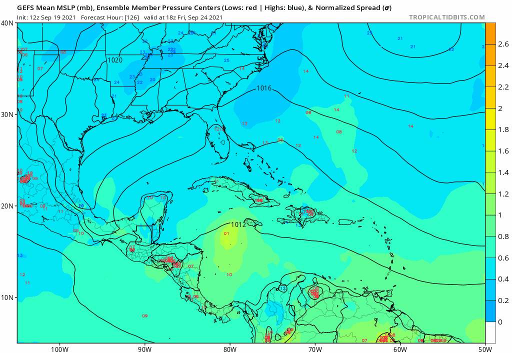
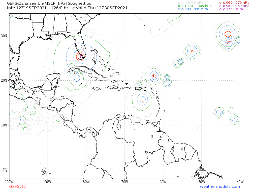
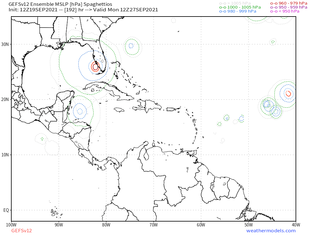
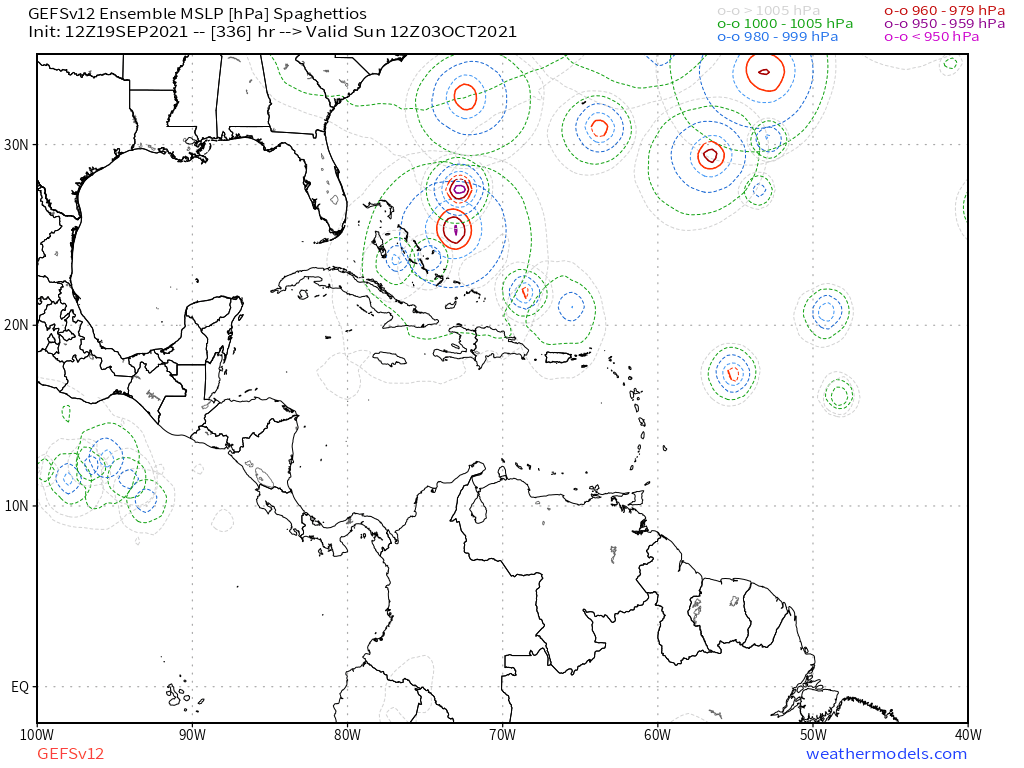
2021 Global Model Runs Discussion (Out thru day 16)

This is the general tropical discussion area. Anyone can take their shot at predicting a storms path.

Moderator: S2k Moderators

Forum rules

The posts in this forum are NOT official forecasts and should not be used as such. They are just the opinion of the poster and may or may not be backed by sound meteorological data. They are NOT endorsed by any professional institution or STORM2K. For official information, please refer to products from the National Hurricane Center and National Weather Service.

Help Support Storm2K
Message
Author
User avatar
Teban54
Category 5
Category 5
Posts: 1952
Joined: Sat May 19, 2018 1:19 pm

Re: 2021 Global Model Runs Discussion (Out thru day 16)

#1621 Postby Teban54 » Fri Sep 17, 2021 5:54 pm

kevin wrote:
kevin wrote:GFS seems to have the same MDR storm around +150 as the 12z Euro. As other people rightfully said earlier in this thread it's still way too soon to say something about this AOI with any real value, but at the very least it's a noteworthy development in the models. I guess I'll wait until it at least enters the +90 region before I really pay a lot of attention to it.

Follow-up to this, happy hour GFS lives up to its name.

https://i.imgur.com/vurVudk.png

At least this time it's not just the Euro! /s

Seriously though, I don't remember the operational GFS ever making 95L this strong at a low latitude when Euro was consistent with a MDR major run to run (though GEFS had some strong members). IIRC GFS was also pretty bearish with 93L. This is more likely than not a one-off thing, though.
1 likes   

User avatar
Category5Kaiju
Category 5
Category 5
Posts: 3351
Age: 22
Joined: Thu Dec 24, 2020 12:45 pm
Location: Seattle

Re: 2021 Global Model Runs Discussion (Out thru day 16)

#1622 Postby Category5Kaiju » Fri Sep 17, 2021 6:04 pm

If the most recent GFS were to verify, then all this talk of this September being inactive and underperforming will bust tremendously. Just sayin'.
1 likes   
Unless explicitly stated, all information covered in my posts is based on my opinions and observations. Please refer to a professional meteorologist or an accredited weather research agency otherwise, especially if serious decisions must be made in the event of a potentially life-threatening tropical storm or hurricane.

IcyTundra
Category 3
Category 3
Posts: 885
Joined: Mon Jun 07, 2021 9:32 pm
Location: Dickinson, Texas

Re: 2021 Global Model Runs Discussion (Out thru day 16)

#1623 Postby IcyTundra » Fri Sep 17, 2021 6:08 pm

Last week of September should be more favorable than it is right now wouldn't surprise me if the GFS is right about two more storms forming in the MDR in the last days of September.
0 likes   

otowntiger
Category 5
Category 5
Posts: 1787
Joined: Tue Aug 31, 2004 7:06 pm
Location: Orlando

Re: 2021 Global Model Runs Discussion (Out thru day 16)

#1624 Postby otowntiger » Fri Sep 17, 2021 7:27 pm

kevin wrote:
kevin wrote:GFS seems to have the same MDR storm around +150 as the 12z Euro. As other people rightfully said earlier in this thread it's still way too soon to say something about this AOI with any real value, but at the very least it's a noteworthy development in the models. I guess I'll wait until it at least enters the +90 region before I really pay a lot of attention to it.


Follow-up to this, happy hour GFS lives up to its name.

https://i.imgur.com/vurVudk.png
I’m sure it will be very different on the very next run.
4 likes   

User avatar
aspen
Category 5
Category 5
Posts: 8056
Joined: Sat Oct 12, 2019 7:10 pm
Location: Connecticut, USA

Re: 2021 Global Model Runs Discussion (Out thru day 16)

#1625 Postby aspen » Sat Sep 18, 2021 11:04 am

The 12z ICON is a full-on fish party by next weekend — ex-Odette, 95L/Rose, 97L/Peter, and another MDR system are all active at that time.
0 likes   
Irene '11 Sandy '12 Hermine '16 5/15/2018 Derecho Fay '20 Isaias '20 Elsa '21 Henri '21 Ida '21

I am only a meteorology enthusiast who knows a decent amount about tropical cyclones. Look to the professional mets, the NHC, or your local weather office for the best information.

User avatar
Category5Kaiju
Category 5
Category 5
Posts: 3351
Age: 22
Joined: Thu Dec 24, 2020 12:45 pm
Location: Seattle

Re: 2021 Global Model Runs Discussion (Out thru day 16)

#1626 Postby Category5Kaiju » Sat Sep 18, 2021 11:34 am

aspen wrote:The 12z ICON is a full-on fish party by next weekend — ex-Odette, 95L/Rose, 97L/Peter, and another MDR system are all active at that time.


That new MDR system could use all of its fish power to boost the ACE of the Atlantic and satisfy those who are worried about ACE
3 likes   
Unless explicitly stated, all information covered in my posts is based on my opinions and observations. Please refer to a professional meteorologist or an accredited weather research agency otherwise, especially if serious decisions must be made in the event of a potentially life-threatening tropical storm or hurricane.

User avatar
Ubuntwo
Category 5
Category 5
Posts: 1089
Age: 30
Joined: Thu Oct 05, 2017 10:41 pm

Re: 2021 Global Model Runs Discussion (Out thru day 16)

#1627 Postby Ubuntwo » Sat Sep 18, 2021 11:53 am

GFS has an active late September - crossing into October. Putting the Kelvin wave to work.
Image
1 likes   
Kendall -> SLO -> PBC

Memorable Storms: Katrina (for its Florida landfall...) Wilma Matthew Irma

psyclone
S2K Supporter
S2K Supporter
Posts: 4487
Joined: Wed Aug 24, 2005 9:04 pm
Location: palm harbor fl

Re: 2021 Global Model Runs Discussion (Out thru day 16)

#1628 Postby psyclone » Sat Sep 18, 2021 11:57 am

any low near the western tip of Cuba in late sept/early october will wake everyone up
9 likes   

User avatar
cajungal
Category 5
Category 5
Posts: 2203
Age: 47
Joined: Sun Mar 14, 2004 9:34 pm
Location: Schriever, Louisiana (60 miles southwest of New Orleans)

Re: 2021 Global Model Runs Discussion (Out thru day 16)

#1629 Postby cajungal » Sat Sep 18, 2021 1:23 pm

psyclone wrote:any low near the western tip of Cuba in late sept/early october will wake everyone up


After Ida looking at that is already giving me severe anxiety
2 likes   

User avatar
aspen
Category 5
Category 5
Posts: 8056
Joined: Sat Oct 12, 2019 7:10 pm
Location: Connecticut, USA

Re: 2021 Global Model Runs Discussion (Out thru day 16)

#1630 Postby aspen » Sat Sep 18, 2021 5:26 pm

Another MDR storm begins forming by Wednesday afternoon on the 18z GFS, and it also appears on the 18z ICON.
0 likes   
Irene '11 Sandy '12 Hermine '16 5/15/2018 Derecho Fay '20 Isaias '20 Elsa '21 Henri '21 Ida '21

I am only a meteorology enthusiast who knows a decent amount about tropical cyclones. Look to the professional mets, the NHC, or your local weather office for the best information.

User avatar
aspen
Category 5
Category 5
Posts: 8056
Joined: Sat Oct 12, 2019 7:10 pm
Location: Connecticut, USA

Re: 2021 Global Model Runs Discussion (Out thru day 16)

#1631 Postby aspen » Sun Sep 19, 2021 5:34 am

All of the global models are now showing another MDR system developing late this week or the weekend. It should probably be on the TWO soon.
1 likes   
Irene '11 Sandy '12 Hermine '16 5/15/2018 Derecho Fay '20 Isaias '20 Elsa '21 Henri '21 Ida '21

I am only a meteorology enthusiast who knows a decent amount about tropical cyclones. Look to the professional mets, the NHC, or your local weather office for the best information.

User avatar
wxman57
Moderator-Pro Met
Moderator-Pro Met
Posts: 22480
Age: 66
Joined: Sat Jun 21, 2003 8:06 pm
Location: Houston, TX (southwest)

Re: 2021 Global Model Runs Discussion (Out thru day 16)

#1632 Postby wxman57 » Sun Sep 19, 2021 9:16 am

The MDR has been quite hostile all season, particularly the western part east of the Caribbean. Like 2020, the eastern MDR has allowed for some significant development (Larry). Models indicate the first real cold front of the season arriving this week, after which time the Gulf may be dominated by strong westerly wind shear for quite a while. This is quite different from last season. The Gulf may be closing for business soon, with the exception of the SE Gulf & Florida late season.

High shear from later this week through Oct. 5th in the latest GFS:
https://www.tropicaltidbits.com/analysis/models/gfs/2021091906/gfs_shear_atl_65.png
8 likes   

User avatar
Category5Kaiju
Category 5
Category 5
Posts: 3351
Age: 22
Joined: Thu Dec 24, 2020 12:45 pm
Location: Seattle

Re: 2021 Global Model Runs Discussion (Out thru day 16)

#1633 Postby Category5Kaiju » Sun Sep 19, 2021 10:08 am

wxman57 wrote:The MDR has been quite hostile all season, particularly the western part east of the Caribbean. Like 2020, the eastern MDR has allowed for some significant development (Larry). Models indicate the first real cold front of the season arriving this week, after which time the Gulf may be dominated by strong westerly wind shear for quite a while. This is quite different from last season. The Gulf may be closing for business soon, with the exception of the SE Gulf & Florida late season.

High shear from later this week through Oct. 5th in the latest GFS:
https://www.tropicaltidbits.com/analysis/models/gfs/2021091906/gfs_shear_atl_65.png


Interestingly enough, the GFS also shows below average shear in the equatorial EPAC. During a La Nina? I find that very strange personally.
3 likes   
Unless explicitly stated, all information covered in my posts is based on my opinions and observations. Please refer to a professional meteorologist or an accredited weather research agency otherwise, especially if serious decisions must be made in the event of a potentially life-threatening tropical storm or hurricane.

User avatar
Category5Kaiju
Category 5
Category 5
Posts: 3351
Age: 22
Joined: Thu Dec 24, 2020 12:45 pm
Location: Seattle

Re: 2021 Global Model Runs Discussion (Out thru day 16)

#1634 Postby Category5Kaiju » Sun Sep 19, 2021 12:13 pm

GFS's most recent run should raise eyebrows. 8-)

Classic late September WCAR system. Takes it into Florida.
4 likes   
Unless explicitly stated, all information covered in my posts is based on my opinions and observations. Please refer to a professional meteorologist or an accredited weather research agency otherwise, especially if serious decisions must be made in the event of a potentially life-threatening tropical storm or hurricane.

User avatar
SFLcane
S2K Supporter
S2K Supporter
Posts: 9606
Age: 46
Joined: Sat Jun 05, 2010 1:44 pm
Location: Lake Worth Florida

Re: 2021 Global Model Runs Discussion (Out thru day 16)

#1635 Postby SFLcane » Sun Sep 19, 2021 1:17 pm

Image

Image

Image

Image

Image
Last edited by SFLcane on Sun Sep 19, 2021 1:46 pm, edited 2 times in total.
2 likes   

User avatar
Category5Kaiju
Category 5
Category 5
Posts: 3351
Age: 22
Joined: Thu Dec 24, 2020 12:45 pm
Location: Seattle

Re: 2021 Global Model Runs Discussion (Out thru day 16)

#1636 Postby Category5Kaiju » Sun Sep 19, 2021 1:20 pm


Definitely keeping an eye on that. Looks like late September/early October is going to be quite threatening should that actually happen.
0 likes   
Unless explicitly stated, all information covered in my posts is based on my opinions and observations. Please refer to a professional meteorologist or an accredited weather research agency otherwise, especially if serious decisions must be made in the event of a potentially life-threatening tropical storm or hurricane.

User avatar
SFLcane
S2K Supporter
S2K Supporter
Posts: 9606
Age: 46
Joined: Sat Jun 05, 2010 1:44 pm
Location: Lake Worth Florida

Re: 2021 Global Model Runs Discussion (Out thru day 16)

#1637 Postby SFLcane » Sun Sep 19, 2021 1:32 pm

That east system is nonsense ain’t nothing make it that far west. The Caribbean well that’s something to keep an eye on. Well see if signal there a week from now.
0 likes   

psyclone
S2K Supporter
S2K Supporter
Posts: 4487
Joined: Wed Aug 24, 2005 9:04 pm
Location: palm harbor fl

Re: 2021 Global Model Runs Discussion (Out thru day 16)

#1638 Postby psyclone » Sun Sep 19, 2021 1:42 pm

A tortuga to treasure coast track would be oh so climo. WX Tiger said a 1 in 3 shot of a huurricane risk to FL in October. Might be more like a 1 in 2 coin toss. Things might get interesting quickly.
1 likes   

User avatar
SFLcane
S2K Supporter
S2K Supporter
Posts: 9606
Age: 46
Joined: Sat Jun 05, 2010 1:44 pm
Location: Lake Worth Florida

Re: 2021 Global Model Runs Discussion (Out thru day 16)

#1639 Postby SFLcane » Sun Sep 19, 2021 1:56 pm

psyclone wrote:A tortuga to treasure coast track would be oh so climo. WX Tiger said a 1 in 3 shot of a huurricane risk to FL in October. Might be more like a 1 in 2 coin toss. Things might get interesting quickly.


GFS ensemble always shows a few things like that this time of year. It's good enough now that if it's a real signal it'll be a lot more obvious and a lot further up in time.
2 likes   

ChrisH-UK
Category 1
Category 1
Posts: 422
Joined: Sat May 29, 2021 8:22 am

Re: 2021 Global Model Runs Discussion (Out thru day 16)

#1640 Postby ChrisH-UK » Sun Sep 19, 2021 2:27 pm


I noticed earlier that there is a small area of rotation near Jamaica, that correlates to that first depression that hits Florida. Going to have to keep an eye on it.
0 likes   


Return to “Talkin' Tropics”

Who is online

Users browsing this forum: Lizzytiz1, revjohn, tolakram and 142 guests