2021 Global Model Runs Discussion (Out thru day 16)
Moderator: S2k Moderators
Forum rules

The posts in this forum are NOT official forecasts and should not be used as such. They are just the opinion of the poster and may or may not be backed by sound meteorological data. They are NOT endorsed by any professional institution or STORM2K. For official information, please refer to products from the National Hurricane Center and National Weather Service.
-
SFLcane

- S2K Supporter

- Posts: 9606
- Age: 46
- Joined: Sat Jun 05, 2010 1:44 pm
- Location: Lake Worth Florida
Re: 2021 Global Model Runs Discussion (Out thru day 16)
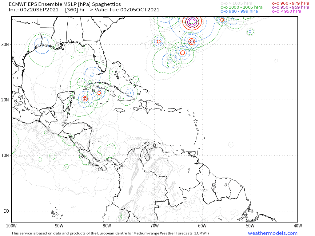
A little more Caribbean long range support. Well see what it looks like in a week.
0 likes
-
AutoPenalti
- Category 5

- Posts: 3949
- Age: 27
- Joined: Mon Aug 17, 2015 4:16 pm
- Location: Ft. Lauderdale, Florida
Re: 2021 Global Model Runs Discussion (Out thru day 16)
I remember last year we had the same thing happen where models began to pinpoint something developing heading towards SFL only for it to move towards the Gulf again.
3 likes
The posts in this forum are NOT official forecasts and should not be used as such. They are just the opinion of the poster and may or may not be backed by sound meteorological data. They are NOT endorsed by any professional institution or STORM2K. For official information, please refer to products from the NHC and NWS.
Model Runs Cheat Sheet:
GFS (5:30 AM/PM, 11:30 AM/PM)
HWRF, GFDL, UKMET, NAVGEM (6:30-8:00 AM/PM, 12:30-2:00 AM/PM)
ECMWF (1:45 AM/PM)
TCVN is a weighted averaged

Re: 2021 Global Model Runs Discussion (Out thru day 16)
AutoPenalti wrote:I remember last year we had the same thing happen where models began to pinpoint something developing heading towards SFL only for it to move towards the Gulf again.
That would probably be Gamma and/or Delta.
If this Caribbean storm forms but the possible MDR system behind 98L forms first, this will get the name Victor. That sounds more fitting for a possible late-season Caribbean major than Teresa.
1 likes
Irene '11 Sandy '12 Hermine '16 5/15/2018 Derecho Fay '20 Isaias '20 Elsa '21 Henri '21 Ida '21
I am only a meteorology enthusiast who knows a decent amount about tropical cyclones. Look to the professional mets, the NHC, or your local weather office for the best information.
I am only a meteorology enthusiast who knows a decent amount about tropical cyclones. Look to the professional mets, the NHC, or your local weather office for the best information.
Re: 2021 Global Model Runs Discussion (Out thru day 16)
Category5Kaiju wrote:Latest GEFS is wild; has many members have 98L develop into a potent hurricane that may miss the islands by a very small margin, has a signature for a Charley-tracked WCAR storm, and has another MDR signature for an early October system after 98L passes. Perhaps this is the "true" peak season for this year? At the end of September?
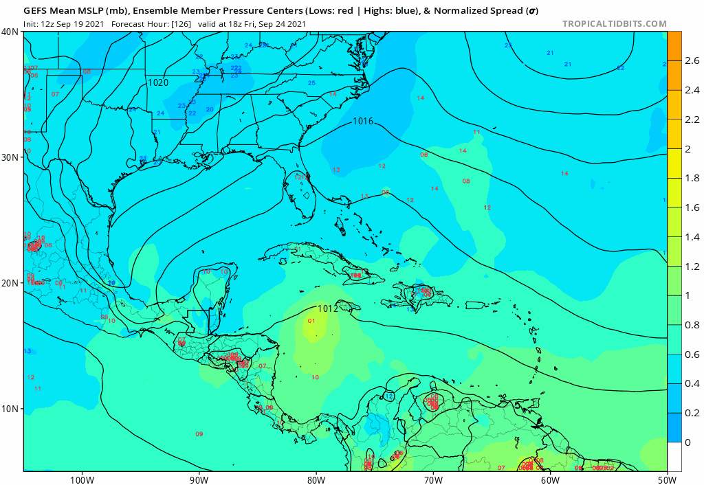
The 6Z GEFS WCAR signal is still pretty weak. But that’s the area most of us will be looking at for the most likely next genesis area for the next potential CONUS threat based on climo. Climo doesn’t say there will be a threat from there but rather that becomes the area most likely to spawn a CONUS threat in early to mid October if there is going to be one. And of course the Gulf as a secondary area. In addition, the area from just E of the Lesser Antilles to north of the Greater Antilles can’t be ignored. But of course, hopefully there will be no more hits this season although I wouldn’t bet on that.
1 likes
Personal Forecast Disclaimer:
The posts in this forum are NOT official forecasts and should not be used as such. They are just the opinion of the poster and may or may not be backed by sound meteorological data. They are NOT endorsed by any professional institution or storm2k.org. For official information, please refer to the NHC and NWS products.
The posts in this forum are NOT official forecasts and should not be used as such. They are just the opinion of the poster and may or may not be backed by sound meteorological data. They are NOT endorsed by any professional institution or storm2k.org. For official information, please refer to the NHC and NWS products.
-
wxman57

- Moderator-Pro Met

- Posts: 22480
- Age: 66
- Joined: Sat Jun 21, 2003 8:06 pm
- Location: Houston, TX (southwest)
Re: 2021 Global Model Runs Discussion (Out thru day 16)
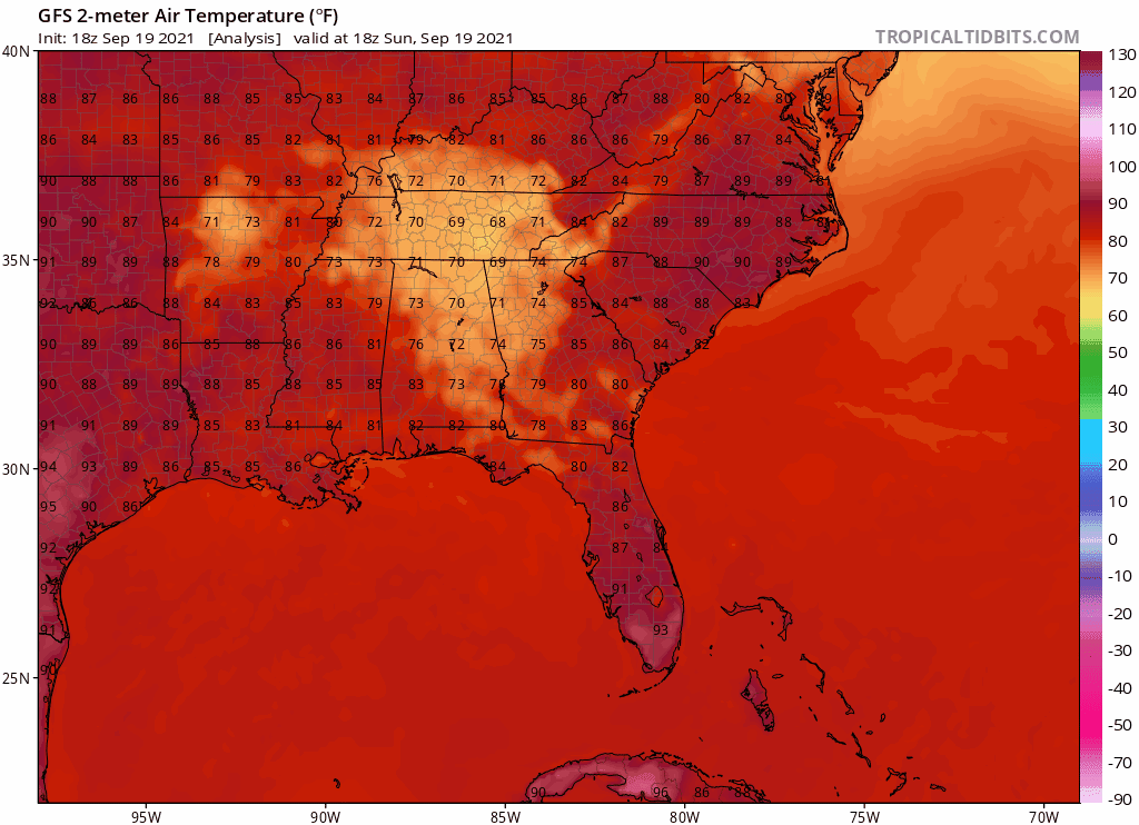
gatorcane wrote:wxman57 wrote:The MDR has been quite hostile all season, particularly the western part east of the Caribbean. Like 2020, the eastern MDR has allowed for some significant development (Larry). Models indicate the first real cold front of the season arriving this week, after which time the Gulf may be dominated by strong westerly wind shear for quite a while. This is quite different from last season. The Gulf may be closing for business soon, with the exception of the SE Gulf & Florida late season.
High shear from later this week through Oct. 5th in the latest GFS:
https://www.tropicaltidbits.com/analysis/models/gfs/2021091906/gfs_shear_atl_65.png
Indeed a very strong front for this time of year which should really put a dent into the warmer SSTs across the northern Gulf:
https://i.postimg.cc/YCtc9ptg/gfs-T2m-seus-fh0-162.gif
It's not the small dent in the SSTs that matters, it's a signal that the jet stream is digging southward into the Gulf, bring lots of westerly shear.
2 likes
-
emeraldislenc
- Category 2

- Posts: 524
- Joined: Fri Aug 24, 2012 4:49 pm
- Location: Emerald Isle NC
Re: 2021 Global Model Runs Discussion (Out thru day 16)
I agree one cold fronts start appearing in the southern states on a regular basis it signals to me that things are changing. I agree with the weather expert on that!
0 likes
-
otowntiger
- Category 5
- Posts: 1787
- Joined: Tue Aug 31, 2004 7:06 pm
- Location: Orlando
Re: 2021 Global Model Runs Discussion (Out thru day 16)
Probabably waaay different.SFLcane wrote:A little more Caribbean long range support. Well see what it looks like in a week.
https://i.postimg.cc/RZgnqXDg/2-FFB5568-5-AD3-4-C64-AB81-54-B035-D2289-E.png
0 likes
-
gatorcane

- S2K Supporter
- Posts: 23499
- Age: 46
- Joined: Sun Mar 13, 2005 3:54 pm
- Location: Boca Raton, FL
Re: 2021 Global Model Runs Discussion (Out thru day 16)
What I find remarkable this season is the compete lack of model canes plowing through Florida particularly in the peak ASO (August/September/October) months so far. In a typical season, you get a handful of runs which level Florida making great fodder and endless speculation for this thread and the model invest threads. This year nothing, even the GFS (Giving Florida Storms) has been crickets. I am certainly not complaining but I think it is surprising some others as well. We will see if it will give us some of that in October, with the so-called “trick or treat” GFS runs. 
4 likes
-
ElectricStorm

- Category 5
- Posts: 4530
- Age: 23
- Joined: Tue Aug 13, 2019 11:23 pm
- Location: Skiatook, OK / Norman, OK
Re: 2021 Global Model Runs Discussion (Out thru day 16)
If the GFS is right, we may have to watch a wave behind 98L for development. It's been on the last few runs, but this is the first one to really develop it.
0 likes
I am in no way a professional. Take what I say with a grain of salt as I could be totally wrong. Please refer to the NHC, NWS, or SPC for official information.
Boomer Sooner!
Boomer Sooner!
-
Stormybajan

- Category 1

- Posts: 428
- Joined: Thu May 20, 2021 3:21 pm
- Location: Windward Islands
Re: 2021 Global Model Runs Discussion (Out thru day 16)
Definitely not a fan of that 0z cmc run tonight. Misses Barbuda by like an inch to prevent a direct hit. Also has a low rider system developing at 240 hours. Hopefully this trend doesnt continue
2 likes
Sad West Indies and Manchester United fan ⚽️
-
Shell Mound
- Category 5
- Posts: 2434
- Age: 31
- Joined: Thu Sep 07, 2017 3:39 pm
- Location: St. Petersburg, FL → Scandinavia
Re: 2021 Global Model Runs Discussion (Out thru day 16)
Category5Kaiju wrote:wxman57 wrote:The MDR has been quite hostile all season, particularly the western part east of the Caribbean. Like 2020, the eastern MDR has allowed for some significant development (Larry). Models indicate the first real cold front of the season arriving this week, after which time the Gulf may be dominated by strong westerly wind shear for quite a while. This is quite different from last season. The Gulf may be closing for business soon, with the exception of the SE Gulf & Florida late season.
High shear from later this week through Oct. 5th in the latest GFS:
https://www.tropicaltidbits.com/analysis/models/gfs/2021091906/gfs_shear_atl_65.png
Interestingly enough, the GFS also shows below average shear in the equatorial EPAC. During a La Nina? I find that very strange personally.
EPAC warm pool at work? N of the Equator SST have been AN in the EPAC.
0 likes
CVW / MiamiensisWx / Shell Mound
The posts in this forum are NOT official forecasts and should not be used as such. They are just the opinion of the poster and may or may not be backed by sound meteorological data. They are NOT endorsed by any professional institution or STORM2K. For official information, please refer to products from the NHC and NWS.
Re: 2021 Global Model Runs Discussion (Out thru day 16)
There’s a single 06z GEFS ensemble member that is essentially a Maria repeat, and it comes from the wave behind 98L. Hopefully 98L is the end of MDR threats.
0 likes
Irene '11 Sandy '12 Hermine '16 5/15/2018 Derecho Fay '20 Isaias '20 Elsa '21 Henri '21 Ida '21
I am only a meteorology enthusiast who knows a decent amount about tropical cyclones. Look to the professional mets, the NHC, or your local weather office for the best information.
I am only a meteorology enthusiast who knows a decent amount about tropical cyclones. Look to the professional mets, the NHC, or your local weather office for the best information.
-
Category5Kaiju

- Category 5
- Posts: 3357
- Age: 22
- Joined: Thu Dec 24, 2020 12:45 pm
- Location: Seattle
Re: 2021 Global Model Runs Discussion (Out thru day 16)
aspen wrote:There’s a single 06z GEFS ensemble member that is essentially a Maria repeat, and it comes from the wave behind 98L. Hopefully 98L is the end of MDR threats.
Yeah no thanks, I really hope that does not happen at all. Having another Cat 4 hit Puerto Rico would lead to ungodly horrific ramifications that I choose to not think of.
1 likes
Unless explicitly stated, all information covered in my posts is based on my opinions and observations. Please refer to a professional meteorologist or an accredited weather research agency otherwise, especially if serious decisions must be made in the event of a potentially life-threatening tropical storm or hurricane.
-
storminabox
- Category 1
- Posts: 260
- Joined: Sun Jul 09, 2017 10:50 pm
Re: 2021 Global Model Runs Discussion (Out thru day 16)
Imagine if the peak of MDR season is in late September (what most models showing with the potential for two strong systems)?! Would be pretty wild!
7 likes
Re: 2021 Global Model Runs Discussion (Out thru day 16)
That second MDR system appears on the 12z ICON. If it forms, it’ll be named Teresa.
0 likes
Irene '11 Sandy '12 Hermine '16 5/15/2018 Derecho Fay '20 Isaias '20 Elsa '21 Henri '21 Ida '21
I am only a meteorology enthusiast who knows a decent amount about tropical cyclones. Look to the professional mets, the NHC, or your local weather office for the best information.
I am only a meteorology enthusiast who knows a decent amount about tropical cyclones. Look to the professional mets, the NHC, or your local weather office for the best information.
Re: 2021 Global Model Runs Discussion (Out thru day 16)
Significant increase in W Caribbean on 12Z GEFS for 9/28+ fwiw.
0 likes
Personal Forecast Disclaimer:
The posts in this forum are NOT official forecasts and should not be used as such. They are just the opinion of the poster and may or may not be backed by sound meteorological data. They are NOT endorsed by any professional institution or storm2k.org. For official information, please refer to the NHC and NWS products.
The posts in this forum are NOT official forecasts and should not be used as such. They are just the opinion of the poster and may or may not be backed by sound meteorological data. They are NOT endorsed by any professional institution or storm2k.org. For official information, please refer to the NHC and NWS products.

Re: 2021 Global Model Runs Discussion (Out thru day 16)
Category5Kaiju wrote:
Definitely keeping an eye on that. Looks like late September/early October is going to be quite threatening should that actually happen.
Looks like the tropics fire a shotgun, to my untrained eye . . . I assume all those red dots are not, in fact, rotating on the inside?
Also, a generic question about models and verification . . . I know there's an overall assessment of accuracy by the NHC regarding their forecasts at large, but has anyone ever done such a thing regarding model forecasts for hurricanes in the GoM, specifically? I mean, overall accuracy regarding storms that inconvenience the fish in the mid-Atlantic is important, too, but if a model was notably better at Gulf storms, that tidbit would be of interest.
1 likes
Baton Rouge area cyclone dilettante, PSWAGGER* tropical weather & hydrology model developer
(* Pseudo-Scientific Wild-A** Guesses Generally Expressed Ridiculously)
The GFDL would've had all this figured out by now.
(* Pseudo-Scientific Wild-A** Guesses Generally Expressed Ridiculously)
The GFDL would've had all this figured out by now.

Re: 2021 Global Model Runs Discussion (Out thru day 16)
LARanger wrote:Category5Kaiju wrote:
Definitely keeping an eye on that. Looks like late September/early October is going to be quite threatening should that actually happen.
Looks like the tropics fire a shotgun, to my untrained eye . . . I assume all those red dots are not, in fact, rotating on the inside?
Also, a generic question about models and verification . . . I know there's an overall assessment of accuracy by the NHC regarding their forecasts at large, but has anyone ever done such a thing regarding model forecasts for hurricanes in the GoM, specifically? I mean, overall accuracy regarding storms that inconvenience the fish in the mid-Atlantic is important, too, but if a model was notably better at Gulf storms, that tidbit would be of interest.
Less observations out in the MDR which leads to more guess work the models have to do.
0 likes

Re: 2021 Global Model Runs Discussion (Out thru day 16)
I know all eyes are on 98L for good reasons, but regarding the wave behind it, seems like recent GFS runs finally agreed with the other models in not immediately sending it straight north on a Rose-like track. Instead, now all models agree on the wave moving west at a rather low latitude, either as a TC or some vorticity. Could be something to watch down the road.
3 likes
Re: 2021 Global Model Runs Discussion (Out thru day 16)
The second wave very quickly develops into Tropical Storm Teresa after moving off the coast of Africa next week on the 12z ICON. Other models are not as consistent or strong, however.
0 likes
Irene '11 Sandy '12 Hermine '16 5/15/2018 Derecho Fay '20 Isaias '20 Elsa '21 Henri '21 Ida '21
I am only a meteorology enthusiast who knows a decent amount about tropical cyclones. Look to the professional mets, the NHC, or your local weather office for the best information.
I am only a meteorology enthusiast who knows a decent amount about tropical cyclones. Look to the professional mets, the NHC, or your local weather office for the best information.
Who is online
Users browsing this forum: Cpv17, NotSparta, pepecool20, StPeteMike, TheAustinMan, Zeta and 222 guests