2021 Personal Forecasts, Discussions

This is the general tropical discussion area. Anyone can take their shot at predicting a storms path.

Moderator: S2k Moderators

Forum rules

The posts in this forum are NOT official forecasts and should not be used as such. They are just the opinion of the poster and may or may not be backed by sound meteorological data. They are NOT endorsed by any professional institution or STORM2K. For official information, please refer to products from the National Hurricane Center and National Weather Service.

Help Support Storm2K
Message
Author
Shell Mound
Category 5
Category 5
Posts: 2434
Age: 31
Joined: Thu Sep 07, 2017 3:39 pm
Location: St. Petersburg, FL → Scandinavia

2021 Personal Forecasts, Discussions

#1 Postby Shell Mound » Thu Mar 11, 2021 3:38 am

aspen wrote:
cycloneye wrote:Crownweather Services is up with 16/8/4 and a repeat of 2017?

https://i.imgur.com/acy6hGg.png

Hopefully the below-average forecast for the WCar holds. Central America really needs a break after Gamma, Delta, Zeta, Eta, and Iota all within 6 weeks.

I’m a bit skeptical about the FL peninsula being at or near the centre of the “high-risk” zone. The FL peninsula is always or nearly always listed as being “high-risk,” but more often than not tends to go unscathed, or nearly so. Of course, exceptions do happen, Irma among them, but I’ve seen—and made—far more “peninsular” seasonal forecasts than have actually verified. This year I think New England and the central Gulf Coast will be the top targets, not the FL peninsula. Given NMME’s forecast(s), a high concentration of early genesis off West Africa, along with poleward steering, means that any CV system that “deviates” westward is more likely to strike Long Island than, say, Miami or even Cape Hatteras. 1954 and 2011 also featured some impacts to the central Gulf Coast, so in that respect 2021 might resemble 2020, albeit on a lesser scale.
3 likes   
CVW / MiamiensisWx / Shell Mound
The posts in this forum are NOT official forecasts and should not be used as such. They are just the opinion of the poster and may or may not be backed by sound meteorological data. They are NOT endorsed by any professional institution or STORM2K. For official information, please refer to products from the NHC and NWS.

User avatar
chaser1
S2K Supporter
S2K Supporter
Posts: 4680
Age: 63
Joined: Sat Oct 15, 2005 5:59 pm
Location: Longwood, Fl

Re: Expert forecasts for 2021 North Atlantic Hurricane Season: Crownweather Services is up

#2 Postby chaser1 » Thu Mar 11, 2021 8:42 am

Shell Mound wrote:
aspen wrote:
cycloneye wrote:Crownweather Services is up with 16/8/4 and a repeat of 2017?

https://i.imgur.com/acy6hGg.png

Hopefully the below-average forecast for the WCar holds. Central America really needs a break after Gamma, Delta, Zeta, Eta, and Iota all within 6 weeks.

I’m a bit skeptical about the FL peninsula being at or near the centre of the “high-risk” zone. The FL peninsula is always or nearly always listed as being “high-risk,” but more often than not tends to go unscathed, or nearly so. Of course, exceptions do happen, Irma among them, but I’ve seen—and made—far more “peninsular” seasonal forecasts than have actually verified. This year I think New England and the central Gulf Coast will be the top targets, not the FL peninsula. Given NMME’s forecast(s), a high concentration of early genesis off West Africa, along with poleward steering, means that any CV system that “deviates” westward is more likely to strike Long Island than, say, Miami or even Cape Hatteras. 1954 and 2011 also featured some impacts to the central Gulf Coast, so in that respect 2021 might resemble 2020, albeit on a lesser scale.


Unfortunately, I do not share your skepticism regarding what could be a year posing an increased threat to the Sunshine State. Though still a bit early for me to already be anticipating this, past history has no bearing on future risk. Mid level steering over the far W. Atlantic and S.E. CONUS certainly does. As to the thought that a poleward (south to north) steering may portend to an increased risk to more northern regions of the E. Seaboard ... this seems reasonable enough of a potential solution. That however could be uncomfortably close for those one or two errant tracks that might just threaten Florida under anomalous strong mid level heights at a point of approach. The other obvious risk to Florida should a cluster of more polar oriented tracks occur between 70-80W, are those tracks originating from the West Central Caribbean. Sure, if one buys fully into the NMME forecast then this would not seem a particularly high risk. Having said that, making such a long range forecast from one forecast tool and proclaiming this guidance removes likelihood of one or two storms tracking or developing over the W. Caribbean would be essentially comical.
1 likes   
Personal Forecast Disclaimer:
The posts in this forum are NOT official forecast and should not be used as such. They are just the opinion of the poster and may or may not be backed by sound meteorological data. They are NOT endorsed by any professional institution or storm2k.org. For official information, please refer to the NHC and NWS products.


Nuno
Category 2
Category 2
Posts: 529
Joined: Fri Aug 30, 2019 8:35 am
Location: Coral Gables, FL

Re: Expert forecasts for 2021 North Atlantic Hurricane Season: Crownweather Services is up

#3 Postby Nuno » Thu Mar 11, 2021 2:07 pm

chaser1 wrote:
Shell Mound wrote:
aspen wrote:Hopefully the below-average forecast for the WCar holds. Central America really needs a break after Gamma, Delta, Zeta, Eta, and Iota all within 6 weeks.

I’m a bit skeptical about the FL peninsula being at or near the centre of the “high-risk” zone. The FL peninsula is always or nearly always listed as being “high-risk,” but more often than not tends to go unscathed, or nearly so. Of course, exceptions do happen, Irma among them, but I’ve seen—and made—far more “peninsular” seasonal forecasts than have actually verified. This year I think New England and the central Gulf Coast will be the top targets, not the FL peninsula. Given NMME’s forecast(s), a high concentration of early genesis off West Africa, along with poleward steering, means that any CV system that “deviates” westward is more likely to strike Long Island than, say, Miami or even Cape Hatteras. 1954 and 2011 also featured some impacts to the central Gulf Coast, so in that respect 2021 might resemble 2020, albeit on a lesser scale.


Unfortunately, I do not share your skepticism regarding what could be a year posing an increased threat to the Sunshine State. Though still a bit early for me to already be anticipating this, past history has no bearing on future risk. Mid level steering over the far W. Atlantic and S.E. CONUS certainly does. As to the thought that a poleward (south to north) steering may portend to an increased risk to more northern regions of the E. Seaboard ... this seems reasonable enough of a potential solution. That however could be uncomfortably close for those one or two errant tracks that might just threaten Florida under anomalous strong mid level heights at a point of approach. The other obvious risk to Florida should a cluster of more polar oriented tracks occur between 70-80W, are those tracks originating from the West Central Caribbean. Sure, if one buys fully into the NMME forecast then this would not seem a particularly high risk. Having said that, making such a long range forecast from one forecast tool and proclaiming this guidance removes likelihood of one or two storms tracking or developing over the W. Caribbean would be essentially comical.


Honestly chaser, you just described like 95% of FL-approaching storms in the last 30 years that just recurved over the Bahamas and instead swiped the OBX or went OTS :P

You're not wrong, of course. Just that "risk" is so normal for SFLoridians that it doesn't even register as such.
0 likes   
Andrew (1992), Irene (1999), Frances (2004), Katrina (2005), Wilma (2005), Fay (2008), Irma (2017), Eta (2020), Ian (2022)

ClarCari
Category 2
Category 2
Posts: 578
Joined: Thu Aug 13, 2020 11:02 am

Re: 2021 Indicators: SST's / SAL / MSLP / Shear / Steering / Instability / Sat Images

#4 Postby ClarCari » Fri Mar 12, 2021 5:09 am

So with what were seeing now, I’m predicting a 2004/2017 like season with long-tracking storms keeping more to the northern-Caribbean with a possible storm or two becoming monsters like Katrina and Rita in the eastern GOM due to the anomalously high loop current SST’s. Also the increasingly anomalous high SST’s by the NE coast is going to potentially put New York City at the worst risk of a major hurricane impact in around a century.

I think the Gulf Stream/Loop Current will play HUGE role in both the GOM and NE U.S., both of which have seen anomalously high SST’s lately.
I mean imagine a season where we see storms such as the Long Island Express and Katrina/Rita in the same year!! Not that unrealistic. :eek:

PLUS+++

I think there very well may be a decent chance of double dipping into the Greeks for the second year in a row, unlike 2004 and 2017. No matter how one’s views on AMO or climate change may be, seasons such as 2018 and 2019 (who’s less cold/warmer ENSO’s were closer to 2006’s ENSO than what 2021’s ENSO is very likely to be!) prove that seasons with 17+ named storms may be more common than it was during 2005 and past decades.

This is just my prediction. But we are only becoming better at predicting these things over time and even though I doubt humanity will ever 100% be able to predict weather, the 2021 hurricane season is one that I already don’t trust no more than a toxic ex coming back into my life after getting comfortable with a new lover. :lol:
2 likes   

Shell Mound
Category 5
Category 5
Posts: 2434
Age: 31
Joined: Thu Sep 07, 2017 3:39 pm
Location: St. Petersburg, FL → Scandinavia

Re: 2021 Indicators: SST's / SAL / MSLP / Shear / Steering / Instability / Sat Images

#5 Postby Shell Mound » Fri Mar 12, 2021 6:10 am

ClarCari wrote:So with what were seeing now, I’m predicting a 2004/2017 like season with long-tracking storms keeping more to the northern-Caribbean with a possible storm or two becoming monsters like Katrina and Rita in the eastern GOM due to the anomalously high loop current SST’s. Also the increasingly anomalous high SST’s by the NE coast is going to potentially put New York City at the worst risk of a major hurricane impact in around a century.

I think the Gulf Stream/Loop Current will play HUGE role in both the GOM and NE U.S., both of which have seen anomalously high SST’s lately.
I mean imagine a season where we see storms such as the Long Island Express and Katrina/Rita in the same year!! Not that unrealistic. :eek:

PLUS+++

I think there very well may be a decent chance of double dipping into the Greeks for the second year in a row, unlike 2004 and 2017. No matter how one’s views on AMO or climate change may be, seasons such as 2018 and 2019 (who’s less cold/warmer ENSO’s were closer to 2006’s ENSO than what 2021’s ENSO is very likely to be!) prove that seasons with 17+ named storms may be more common than it was during 2005 and past decades.

This is just my prediction. But we are only becoming better at predicting these things over time and even though I doubt humanity will ever 100% be able to predict weather, the 2021 hurricane season is one that I already don’t trust no more than a toxic ex coming back into my life after getting comfortable with a new lover. :lol:

Personally, I don’t really count most of the short-lived systems that have been classified since 2005. I think (M)H activity and ACE are far better indicators of activity than total NS. 2020, tied alongside seven other seasons, had the second-highest number of major hurricanes on record, six in all; with thirteen, 2020 also featured the second-highest number of hurricanes on record. It will be extremely difficult to top 2020’s statistics in these areas, and extraordinary to do so in a consecutive season. On the other hand, even with a lower NS total, ACE may well be higher in 2021 vs. 2020 if the CV season ends up being active, which seems quite plausible at this point. Regarding 2004 and 2017 as analogs, I don’t think those years exactly match your Gulf-and-Northeast-centric outlook, given that most of the landfalling hurricanes in these seasons ended up striking the Florida peninsula, with only a smattering deviating into the Gulf or the Carolinas. Nothing impacted the Northeastern U.S. during either of those seasons. 2004 and 2017 are actually somewhat closer, albeit remotely, to CrownWeather’s analogs in terms of tracks. 1938 featured a completely different steering regime from that of 2004/‘17.
0 likes   
CVW / MiamiensisWx / Shell Mound
The posts in this forum are NOT official forecasts and should not be used as such. They are just the opinion of the poster and may or may not be backed by sound meteorological data. They are NOT endorsed by any professional institution or STORM2K. For official information, please refer to products from the NHC and NWS.

tolakram
Admin
Admin
Posts: 19165
Age: 60
Joined: Sun Aug 27, 2006 8:23 pm
Location: Florence, KY (name is Mark)

2021 personal forecasts, seasonal thoughts

#6 Postby tolakram » Fri Mar 12, 2021 8:35 am

Please post your thoughts on the season here. Give reasoning please, rather than just simple statements. Use this thread as a place to discuss your ideas on the season rather than filling multiple 2021 threads with the same ideas.
4 likes   
M a r k
- - - - -
Join us in chat: Storm2K Chatroom Invite. Android and IOS apps also available.

The posts in this forum are NOT official forecasts and should not be used as such. Posts are NOT endorsed by any professional institution or STORM2K.org. For official information and forecasts, please refer to NHC and NWS products.

User avatar
Iceresistance
Category 5
Category 5
Posts: 8909
Age: 20
Joined: Sat Oct 10, 2020 9:45 am
Location: Tecumseh, OK/Norman, OK

Re: 2021 personal forecasts, seasonal thoughts

#7 Postby Iceresistance » Fri Mar 12, 2021 8:42 am

I'll not do any personal forecasts until at least April becasue the La Nina that is expected to restrengthen may not happen at all, like in 2018 when the expected El Nino that was supposed to form never did . . .

But I'm thinking an above-Average Season for 2021, even though that it's unlikely that it will rival 2020 or 2005 . . .

My personal forecast in 2020 would be 30-11-3-1 (TS-C1-C3-C5) with ACE of 170 (How did I get that thought right!? What are the odds!?? :eek:), but I did not know S2K existed until October 2020!

Would I be banned or looked down upon if I posted my 2020 Personal Forecast Last April? :lol:
0 likes   
Bill 2015 & Beta 2020

Winter 2020-2021 :cold:

All observations are in Tecumseh, OK unless otherwise noted.

Winter posts are focused mainly for Oklahoma & Texas.

Take any of my forecasts with a grain of salt, refer to the NWS, SPC, and NHC for official information

Never say Never with weather! Because ANYTHING is possible!

User avatar
Category5Kaiju
Category 5
Category 5
Posts: 3346
Age: 22
Joined: Thu Dec 24, 2020 12:45 pm
Location: Seattle

Re: 2021 Personal Forecasts, Discussions

#8 Postby Category5Kaiju » Sun Mar 14, 2021 4:43 pm

I think it is still a bit early to give out numbers, although if conditions become favorable as predicted (warm sst anomalies, weak Nina, etc.) a hyperactive or at the very least a very active season cannot be ruled out. I do think this season has the potential to be a bad one, and especially for Gulf residents, I hope they understand that in recent years Gulf storms have not been weakening until landfall as easily as before.
0 likes   
Unless explicitly stated, all information covered in my posts is based on my opinions and observations. Please refer to a professional meteorologist or an accredited weather research agency otherwise, especially if serious decisions must be made in the event of a potentially life-threatening tropical storm or hurricane.

User avatar
cycloneye
Admin
Admin
Posts: 139011
Age: 67
Joined: Thu Oct 10, 2002 10:54 am
Location: San Juan, Puerto Rico

Re: 2021 Personal Forecasts, Discussions

#9 Postby cycloneye » Sun Mar 14, 2021 4:50 pm

A reminder that the 2021 Storm2k numbers poll will begin on April 1 so get ready for that.
0 likes   
Visit the Caribbean-Central America Weather Thread where you can find at first post web cams,radars
and observations from Caribbean basin members Click Here

BadLarry95
Tropical Depression
Tropical Depression
Posts: 94
Joined: Thu Apr 28, 2016 9:40 pm

Re: 2021 Personal Forecasts, Discussions

#10 Postby BadLarry95 » Sun Mar 14, 2021 6:49 pm

Preliminary ranged forecast:

16-19 NS
7-9 H
3-5 MH

3 retired:
Ida, Larry, Peter
0 likes   

User avatar
aspen
Category 5
Category 5
Posts: 8054
Joined: Sat Oct 12, 2019 7:10 pm
Location: Connecticut, USA

Re: 2021 Personal Forecasts, Discussions

#11 Postby aspen » Sun Mar 14, 2021 7:08 pm

I’m not feeling very aggressive with my numbers so far.

Named storms: 12-17
Hurricanes: 4-7
Majors: 2-4
ACE: 90-140
ICE: 300-500 (mean: 388)

While ENSO will be anything from neutral to cool by ASO based on recent forecasts, so far I’m not seeing that much that makes me confidently say “yes, we’re going to have another crazy season this year”. I’m playing it safe with average to “normal” above-average numbers, nothing crazy and nothing near the madness of 2020.

Signs I’m basing this on:
—Likely double-dip into cool ENSO
—Standing wave and lots of moisture over Africa like in 2020 (active AEW train)
—Potentially drier-than-normal W Caribbean
—Currently cooler MDR and Caribbean SST anomalies compared to 2020 at this time
Last edited by aspen on Sun Mar 14, 2021 7:19 pm, edited 1 time in total.
0 likes   
Irene '11 Sandy '12 Hermine '16 5/15/2018 Derecho Fay '20 Isaias '20 Elsa '21 Henri '21 Ida '21

I am only a meteorology enthusiast who knows a decent amount about tropical cyclones. Look to the professional mets, the NHC, or your local weather office for the best information.

tolakram
Admin
Admin
Posts: 19165
Age: 60
Joined: Sun Aug 27, 2006 8:23 pm
Location: Florence, KY (name is Mark)

Re: 2021 Personal Forecasts, Discussions

#12 Postby tolakram » Sun Mar 14, 2021 7:14 pm

Please don't use this as a numbers thread :) Forecasts and discussions please.
1 likes   
M a r k
- - - - -
Join us in chat: Storm2K Chatroom Invite. Android and IOS apps also available.

The posts in this forum are NOT official forecasts and should not be used as such. Posts are NOT endorsed by any professional institution or STORM2K.org. For official information and forecasts, please refer to NHC and NWS products.

User avatar
Hurricaneman
Category 5
Category 5
Posts: 7280
Age: 43
Joined: Tue Aug 31, 2004 3:24 pm
Location: central florida

Re: 2021 Personal Forecasts, Discussions

#13 Postby Hurricaneman » Sun Mar 14, 2021 11:36 pm

My Forecast for the 2021 season

I Also feel like we may need to watch the Eastern seaboard in April

I feel like May will have a system most likely off the eastern seaboard

June will have a system or 2 in the eastern GOM

July may be similar to June

August may have quick developments in the MDR but dry air might be a problem if the - Tripole continues but if anything gets north of the Antilles especially late in the month with low shear the SE US may have problems especially looking at possible pressure patterns

September will probably have a big one that rides from just off the Florida Coast all the way to the NE US

October will be quiet IMO with maybe a system at the end of the month

November\December will be quiet

What is the Basis for this forecast?

- Atlantic Tripole\Warm North of 20
Low Shear
Dry stable Air in the Caribbean
wet African Monsoon
-ENSO
Steering has storms moving close to North America if they develop later but out to sea if the develop early

Ill Give my numbers 14\6\2 but will be updated on the numbers thread on April 1st and may 1st
0 likes   

User avatar
aspen
Category 5
Category 5
Posts: 8054
Joined: Sat Oct 12, 2019 7:10 pm
Location: Connecticut, USA

Re: 2021 Personal Forecasts, Discussions

#14 Postby aspen » Mon Mar 15, 2021 8:10 am

After thinking it over, I’m going to up my March forecast range.

NS: 14-18
H: 5-8
MH: 3-5
ACE: 110-150
ICE: 400-550

While the Caribbean could be far less active in 2021 and the tropics might not be as warm as they were in 2020, overall, the setup for this season is looking solid — active AEW train, moist MDR, potential for long tracking storms, rising branch over Africa/IO, neutral to cool ENSO, etc. It seems highly unlikely for this season to produce anything below average numbers. While I’m not convinced of a truly hyperactive year like 2017 (in terms of ACE) or 2020 (in terms of NS), we could still get a pretty active season, and if this is a more MDR-focused year like 2010 or 2011, perhaps we could see a higher percentage of quality, high-ACE (>15-20) storms as compared to 2020.

At the minimum, I think we could set a season on the high end of average (14/5/3, 110 ACE). The maximum is probably a borderline hyperactive season in terms of ACE and possibly comparable to 2017 or 2019 in terms of storm numbers (18/8/5, 150 ACE).
0 likes   
Irene '11 Sandy '12 Hermine '16 5/15/2018 Derecho Fay '20 Isaias '20 Elsa '21 Henri '21 Ida '21

I am only a meteorology enthusiast who knows a decent amount about tropical cyclones. Look to the professional mets, the NHC, or your local weather office for the best information.

User avatar
InfernoFlameCat
Category 5
Category 5
Posts: 1966
Age: 21
Joined: Mon Dec 14, 2020 10:52 am
Location: Buford, GA

Re: 2021 Personal Forecasts, Discussions

#15 Postby InfernoFlameCat » Mon Mar 15, 2021 8:58 am

Here is mine and I am using 2011 as an analog.

19 NS
8 H
4 MH
1 C5 :wink:
150 ACE
0 likes   
I am by no means a professional. DO NOT look at my forecasts for official information or make decisions based on what I post.

Goal: to become a registered expert over tropical and subtropical cyclones.

Wampadawg
Tropical Storm
Tropical Storm
Posts: 194
Joined: Wed Oct 14, 2020 10:28 am
Location: South Texas

Re: 2021 Personal Forecasts, Discussions

#16 Postby Wampadawg » Sat Apr 17, 2021 12:44 pm

Still a storm newbie what does everyone thing about a storm hitting the Texas area !
I am reading lots of articles, lots of information
But lots of contradictions :double:
I guess wait and see.nothing scientific, but I can’t shake this feeling that i have we will get hit hard.
14 named
6-8 hurricanes
4 major
0 likes   
Harvey,Hanna,Beta,Texas Winter storm2021,Nicholas

Shell Mound
Category 5
Category 5
Posts: 2434
Age: 31
Joined: Thu Sep 07, 2017 3:39 pm
Location: St. Petersburg, FL → Scandinavia

Re: 2021 Personal Forecasts, Discussions

#17 Postby Shell Mound » Mon May 03, 2021 8:40 am

Image
Image
Image
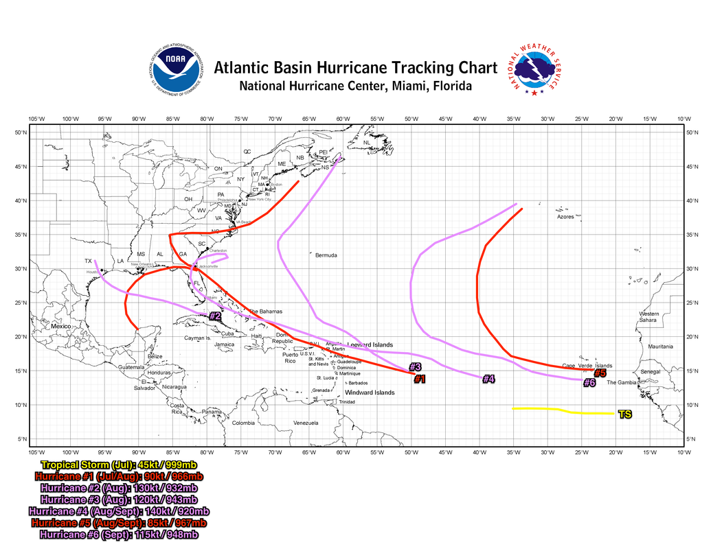
Possible scenario for 2021 (top, middle) vs. verified tracks (bottom) in 2020 (bottom), based on a few isolated runs—not a (finalised) forecast
  • To verify, ENSO would need to be cool neutral and east-based, coupled with +AMO and active African monsoon
  • Example (adjusted EC forecast): Image
Last edited by Shell Mound on Tue May 04, 2021 6:05 am, edited 1 time in total.
2 likes   
CVW / MiamiensisWx / Shell Mound
The posts in this forum are NOT official forecasts and should not be used as such. They are just the opinion of the poster and may or may not be backed by sound meteorological data. They are NOT endorsed by any professional institution or STORM2K. For official information, please refer to products from the NHC and NWS.

User avatar
Hypercane_Kyle
Category 5
Category 5
Posts: 2899
Joined: Sat Mar 07, 2015 7:58 pm
Location: Cape Canaveral, FL

Re: 2021 Personal Forecasts, Discussions

#18 Postby Hypercane_Kyle » Mon May 03, 2021 9:03 am

I'm going with

18 named
8 hurricanes
4 majors
0 likes   
My posts are my own personal opinion, defer to the National Hurricane Center (NHC) and other NOAA products for decision making during hurricane season.

User avatar
Iceresistance
Category 5
Category 5
Posts: 8909
Age: 20
Joined: Sat Oct 10, 2020 9:45 am
Location: Tecumseh, OK/Norman, OK

Re: 2021 Personal Forecasts, Discussions

#19 Postby Iceresistance » Mon May 03, 2021 9:25 am

Shell Mound wrote:https://i.postimg.cc/FFxbpFqB/2021scenario.png
https://upload.wikimedia.org/wikipedia/commons/thumb/3/3c/2020_Atlantic_hurricane_season_summary_map.png/600px-2020_Atlantic_hurricane_season_summary_map.png
Possible scenario for 2021 (top) vs. verified tracks in 2020 (bottom), based on a few isolated runs—not a (finalised) forecast


Oh no, I hope that's not the case for Florida!
0 likes   
Bill 2015 & Beta 2020

Winter 2020-2021 :cold:

All observations are in Tecumseh, OK unless otherwise noted.

Winter posts are focused mainly for Oklahoma & Texas.

Take any of my forecasts with a grain of salt, refer to the NWS, SPC, and NHC for official information

Never say Never with weather! Because ANYTHING is possible!

User avatar
FireRat
Category 5
Category 5
Posts: 1138
Age: 36
Joined: Sun Sep 26, 2010 11:38 pm
Location: North Carolina

Re: 2021 Personal Forecasts, Discussions

#20 Postby FireRat » Mon May 10, 2021 12:29 am

FireRat's take on 2021 Atlantic Hurricane Season... Using the Chinese Zodiac:
Sup guys, was thinking of making a separate thread for 2021 like I did for 2020 using the Chinese Zodiac lol, but figured I'd give a quick preview here on my thinking.

Since this zodiac is actually 12 year (and 60 year cycles, when we take the 5 elements into account), the 2021 season may have things in common with the following seasons based on this alone...

2009, 1997, 1985, 1973, 1961, 1949, 1937, 1925, 1913, 1901, 1889, 1877 and so on.

The sixty year cycle (Metal Ox year) puts 2021 alongside 1961, 1901, 1841 and 1781. The biggest year here would be 1961, the year of Hurricane Carla.

Most of the other 'years of the Ox' like 2009, 1997 and 1925 were quite slow. This makes me think that 2021 could end up being slower than many are anticipating, and this could be welcome news based on this esoteric 'crystal ball' method.

I might go with 12 to 15 named storms, 4-6 hurricanes, and 2-3 majors.... somewhat average if not just a little below the new 1991 - 2020 average. A possible similarity to 1961 and the sheer numbers being predicted by the experts skews my expectations a bit upwards.

This doesn't rule out a monster hurricane or severe landfall though. Some of the Ox Years like 1985, 1961 and 1949 featured strong landfalls. Most likely locations to be struck by a significant, Cat 2+ hurricane in 2021 based on past Ox years would be the MS to Central FL Gulf Coast, the Texas Coast, and to a lower extent Central America and perhaps NC which has been brushed on several of those years.

South Florida in particular, has only been struck twice during an Ox year since record keeping began, one in 1865 and one in 1949. The Bahamas were similarly lucky. The Greater Antilles and Lesser Antilles were even luckier with few, if any, strong landfalls during this year cycle.

In 2021 we could see a Cat 2+ hurricane or two strike along the Gulf Coast, most likely near where Carla came ashore in 1961 and also between MS and FL about where Danny came ashore in 1997. North Carolina's outer banks might also get a brush or two.
Central America could see a hurricane later in the season, especially Yucatan south to Honduras.

The year of the Ox is one of the most uneventful ones in the Atlantic historically, so my 2 cents is that the season will be slower than anticipated and hopefully this is good news after such a disastrous 2020 season. 8-)

If you're in the West Pacific however, oh boy!
Big difference right there, 2021 could be a huuuge season, much like 2009 and 1997. :eek:
3 likes   
Georges '98, Irene '99, Frances '04, Jeanne '04, Katrina '05, Wilma '05, Gustav '08, Isaac '12, Matthew '16, Florence '18, Michael '18, Ian '22


Return to “Talkin' Tropics”

Who is online

Users browsing this forum: Beef Stew, Iceresistance and 65 guests