Strong Tropical Wave to emerge from West Africa today (Is Invest 95L)
Moderator: S2k Moderators
Forum rules

The posts in this forum are NOT official forecasts and should not be used as such. They are just the opinion of the poster and may or may not be backed by sound meteorological data. They are NOT endorsed by any professional institution or STORM2K. For official information, please refer to products from the National Hurricane Center and National Weather Service.


Re: Strong Tropical Wave to emerge from West Africa early this week
Just thinking out loud here, but I noticed that the area of thunderstorms behind the area the NHC has been focusing on seems far more robust than the one in front of it. Perhaps this is why the models just suddenly went slack on it, because they are readjusting to the idea of the other wave being more dominant? It looks pretty darn good to me and definitely has rotation.
0 likes
Re: Strong Tropical Wave to emerge from West Africa early this week
12Z EPS 240: much less active than prior runs leading to a good bit further west mean though most of these should still recurve well OTS from the CONUS. Let's see what the later maps of this run show:
240:

240:
1 likes
Personal Forecast Disclaimer:
The posts in this forum are NOT official forecasts and should not be used as such. They are just the opinion of the poster and may or may not be backed by sound meteorological data. They are NOT endorsed by any professional institution or storm2k.org. For official information, please refer to the NHC and NWS products.
The posts in this forum are NOT official forecasts and should not be used as such. They are just the opinion of the poster and may or may not be backed by sound meteorological data. They are NOT endorsed by any professional institution or storm2k.org. For official information, please refer to the NHC and NWS products.
-
Spacecoast

- Category 2

- Posts: 687
- Joined: Thu Aug 31, 2017 2:03 pm
Re: Strong Tropical Wave to emerge from West Africa early this week
LarryWx wrote:12Z EPS 240: much less active than prior runs leading to a good bit further west mean though most of these should still recurve well OTS from the CONUS. Let's see what the later maps of this run show:
240:
https://i.imgur.com/60FnEfh.png
How much of that further west is due to quicker movement? idk
The ensemble mean still passes east of 25N, 65W, and has been that way for quite a while, right?
1 likes
-
AutoPenalti
- Category 5

- Posts: 3949
- Age: 27
- Joined: Mon Aug 17, 2015 4:16 pm
- Location: Ft. Lauderdale, Florida
Re: Strong Tropical Wave to emerge from West Africa on Monday
12z Euro doesn’t surprise me considering this is still inland.
0 likes
The posts in this forum are NOT official forecasts and should not be used as such. They are just the opinion of the poster and may or may not be backed by sound meteorological data. They are NOT endorsed by any professional institution or STORM2K. For official information, please refer to products from the NHC and NWS.
Model Runs Cheat Sheet:
GFS (5:30 AM/PM, 11:30 AM/PM)
HWRF, GFDL, UKMET, NAVGEM (6:30-8:00 AM/PM, 12:30-2:00 AM/PM)
ECMWF (1:45 AM/PM)
TCVN is a weighted averaged


Re: Strong Tropical Wave to emerge from West Africa early this week
Category5Kaiju wrote:WiscoWx02 wrote:It's not just the EURO that poofs it either. HWRF run totally dropped it too. Will be interesting to see the next set of runs but doubt they will show anything either if past experience means anything. Wonder why all the models just decided to jump off the cliff on this one.....
Operational runs that is. EPS/GFS ensemble will be the real indicator if we have been chasing a ghost this whole time or not.
Many GEPS and GEFS members still show this system.
That may change also. Wave and model watching this season has been downright maddening.
0 likes
Re: Strong Tropical Wave to emerge from West Africa early this week
LarryWx wrote:12Z EPS 240: much less active than prior runs leading to a good bit further west mean though most of these should still recurve well OTS from the CONUS. Let's see what the later maps of this run show:
240:
https://i.imgur.com/60FnEfh.png
Followup: ~10% of the members end up a CONUS threat or a close miss. Here's the end of the run:

1 likes
Personal Forecast Disclaimer:
The posts in this forum are NOT official forecasts and should not be used as such. They are just the opinion of the poster and may or may not be backed by sound meteorological data. They are NOT endorsed by any professional institution or storm2k.org. For official information, please refer to the NHC and NWS products.
The posts in this forum are NOT official forecasts and should not be used as such. They are just the opinion of the poster and may or may not be backed by sound meteorological data. They are NOT endorsed by any professional institution or storm2k.org. For official information, please refer to the NHC and NWS products.
-
otowntiger
- Category 5
- Posts: 1787
- Joined: Tue Aug 31, 2004 7:06 pm
- Location: Orlando
Re: Strong Tropical Wave to emerge from West Africa early this week
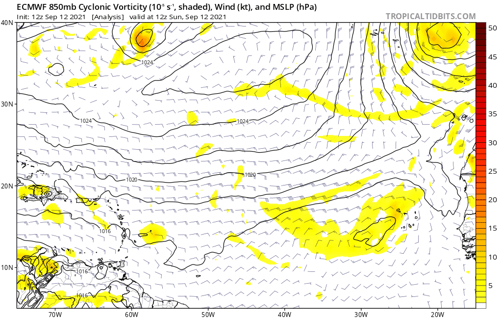
yep- it does take it much further west, but practically dissipates it as it depicts it steadily weakening the further west it gets. Models currently not too enthused about anything over the next couple weeks it looks like. Seems kinda weird for this time of year.gatorcane wrote:Weak on the 12Z Euro may = much more west.
https://i.postimg.cc/8zts8jcM/ecmwf-uv850-vort-eatl-fh0-120.gif
0 likes
-
Category5Kaiju

- Category 5
- Posts: 3351
- Age: 22
- Joined: Thu Dec 24, 2020 12:45 pm
- Location: Seattle
Re: Strong Tropical Wave to emerge from West Africa early this week
otowntiger wrote:yep- it does take it much further west, but practically dissipates it as it depicts it steadily weakening the further west it gets. Models currently not too enthused about anything over the next couple weeks it looks like. Seems kinda weird for this time of year.gatorcane wrote:Weak on the 12Z Euro may = much more west.
https://i.postimg.cc/8zts8jcM/ecmwf-uv850-vort-eatl-fh0-120.gif
The models are not enthused about anything in the EPAC either, and when have the models been very and consistently enthused about Atlantic development this season honestly? Especially earlier in the season with all of that EPAC ghost storms and Atlantic nothingness…either way, my point is I am honestly not shocked that the models are not enthused about peak Atlantic season development. Obviously I find it very unlikely that the Atlantic and the EPAC for what it’s worth will be as quiet as the models think this month.
1 likes
Unless explicitly stated, all information covered in my posts is based on my opinions and observations. Please refer to a professional meteorologist or an accredited weather research agency otherwise, especially if serious decisions must be made in the event of a potentially life-threatening tropical storm or hurricane.
Re: Strong Tropical Wave to emerge from West Africa early this week
Category5Kaiju wrote:otowntiger wrote:yep- it does take it much further west, but practically dissipates it as it depicts it steadily weakening the further west it gets. Models currently not too enthused about anything over the next couple weeks it looks like. Seems kinda weird for this time of year.gatorcane wrote:Weak on the 12Z Euro may = much more west.
https://i.postimg.cc/8zts8jcM/ecmwf-uv850-vort-eatl-fh0-120.gif
The models are not enthused about anything in the EPAC either, and when have the models been very and consistently enthused about Atlantic development this season honestly? Especially earlier in the season with all of that EPAC ghost storms and Atlantic nothingness…either way, my point is I am honestly not shocked that the models are not enthused about peak Atlantic season development. Obviously I find it very unlikely that the Atlantic and the EPAC for what it’s worth will be as quiet as the models think this month.
No matter what, September will not end up quiet as it has already had Larry, Mindy and Nicholas and it is only Sept 12 with 2 additional pretty strong candidates for genesis!
0 likes
Personal Forecast Disclaimer:
The posts in this forum are NOT official forecasts and should not be used as such. They are just the opinion of the poster and may or may not be backed by sound meteorological data. They are NOT endorsed by any professional institution or storm2k.org. For official information, please refer to the NHC and NWS products.
The posts in this forum are NOT official forecasts and should not be used as such. They are just the opinion of the poster and may or may not be backed by sound meteorological data. They are NOT endorsed by any professional institution or storm2k.org. For official information, please refer to the NHC and NWS products.

Re: Strong Tropical Wave to emerge from West Africa early this week
LarryWx wrote:LarryWx wrote:12Z EPS 240: much less active than prior runs leading to a good bit further west mean though most of these should still recurve well OTS from the CONUS. Let's see what the later maps of this run show:
240:
https://i.imgur.com/60FnEfh.png
Followup: ~10% of the members end up a CONUS threat or a close miss. Here's the end of the run:
https://i.imgur.com/yCSqwhE.png
A good amount of those members get into the large swath of high OHC and 29.5-30C SSTs north of the Greater Antilles. Even if this system remains weak for the entirety of its trek in the MDR, I am very concerned about the possibility of RI into a powerful major once it gets into that region.
1 likes
Irene '11 Sandy '12 Hermine '16 5/15/2018 Derecho Fay '20 Isaias '20 Elsa '21 Henri '21 Ida '21
I am only a meteorology enthusiast who knows a decent amount about tropical cyclones. Look to the professional mets, the NHC, or your local weather office for the best information.
I am only a meteorology enthusiast who knows a decent amount about tropical cyclones. Look to the professional mets, the NHC, or your local weather office for the best information.
-
toad strangler

- S2K Supporter

- Posts: 4162
- Joined: Sun Jul 28, 2013 3:09 pm
- Location: Earth
- Contact:
Re: Strong Tropical Wave to emerge from West Africa early this week
otowntiger wrote:yep- it does take it much further west, but practically dissipates it as it depicts it steadily weakening the further west it gets. Models currently not too enthused about anything over the next couple weeks it looks like. Seems kinda weird for this time of year.gatorcane wrote:Weak on the 12Z Euro may = much more west.
https://i.postimg.cc/8zts8jcM/ecmwf-uv850-vort-eatl-fh0-120.gif
Models will be inaccurate in this regards
0 likes
-
ElectricStorm

- Category 5
- Posts: 4523
- Age: 23
- Joined: Tue Aug 13, 2019 11:23 pm
- Location: Skiatook, OK / Norman, OK
Re: Strong Tropical Wave to emerge from West Africa on Monday
Models are generally bad when it comes to waves still over Africa, however if the Euro does end up verifying and it stays weaker, it will likely be more if a concern further west down the road. It would be better if this gets going earlier so it goes further north
2 likes
I am in no way a professional. Take what I say with a grain of salt as I could be totally wrong. Please refer to the NHC, NWS, or SPC for official information.
Boomer Sooner!
Boomer Sooner!
-
SFLcane

- S2K Supporter
- Posts: 9606
- Age: 46
- Joined: Sat Jun 05, 2010 1:44 pm
- Location: Lake Worth Florida
Re: Strong Tropical Wave to emerge from West Africa on Monday
Noticed some of these Eps members hooking west and some even wsw. Quite the spread

1 likes
-
Category5Kaiju
- Category 5
- Posts: 3351
- Age: 22
- Joined: Thu Dec 24, 2020 12:45 pm
- Location: Seattle
Re: Strong Tropical Wave to emerge from West Africa on Monday
SFLcane wrote:Noticed some of these Eps members hooking west and some even wsw. Quite the spread
https://i.postimg.cc/bvzmhT69/320977-DC-7-FB1-463-E-96-DF-258-AED116785.png
So at this point in time we know two definitive things:
1. Contrary to the GFS and Euro operational runs, the ensembles are still keen on this AOI becoming a named storm.
2. Unlike Larry, there is a chance that this treks more westward, so it at this point in time is not a slam dunk OTS fish storm (as there are also a myriad of volatile factors that could come into play and influence troughing and ridging).
0 likes
Unless explicitly stated, all information covered in my posts is based on my opinions and observations. Please refer to a professional meteorologist or an accredited weather research agency otherwise, especially if serious decisions must be made in the event of a potentially life-threatening tropical storm or hurricane.
Re: Strong Tropical Wave to emerge from West Africa on Monday
Category5Kaiju wrote:SFLcane wrote:Noticed some of these Eps members hooking west and some even wsw. Quite the spread
https://i.postimg.cc/bvzmhT69/320977-DC-7-FB1-463-E-96-DF-258-AED116785.png
So at this point in time we know two definitive things:
1. Contrary to the GFS and Euro operational runs, the ensembles are still keen on this AOI becoming a named storm.
2. Unlike Larry, there is a chance that this treks more westward, so it at this point in time is not a slam dunk OTS fish storm (as there are also a myriad of volatile factors that could come into play and influence troughing and ridging).
Anyone saying "Slam dunk OTS fish storm" now with regard to this AEW isn't knowlegable about the tropics and its climo.
6 likes
Personal Forecast Disclaimer:
The posts in this forum are NOT official forecasts and should not be used as such. They are just the opinion of the poster and may or may not be backed by sound meteorological data. They are NOT endorsed by any professional institution or storm2k.org. For official information, please refer to the NHC and NWS products.
The posts in this forum are NOT official forecasts and should not be used as such. They are just the opinion of the poster and may or may not be backed by sound meteorological data. They are NOT endorsed by any professional institution or storm2k.org. For official information, please refer to the NHC and NWS products.
-
Category5Kaiju
- Category 5
- Posts: 3351
- Age: 22
- Joined: Thu Dec 24, 2020 12:45 pm
- Location: Seattle
Re: Strong Tropical Wave to emerge from West Africa on Monday
LarryWx wrote:Category5Kaiju wrote:SFLcane wrote:Noticed some of these Eps members hooking west and some even wsw. Quite the spread
https://i.postimg.cc/bvzmhT69/320977-DC-7-FB1-463-E-96-DF-258-AED116785.png
So at this point in time we know two definitive things:
1. Contrary to the GFS and Euro operational runs, the ensembles are still keen on this AOI becoming a named storm.
2. Unlike Larry, there is a chance that this treks more westward, so it at this point in time is not a slam dunk OTS fish storm (as there are also a myriad of volatile factors that could come into play and influence troughing and ridging).
Anyone saying "Slam dunk OTS fish storm" now with regard to this AEW isn't knowlegable about the tropics and its climo.
I know; but it seems as if especially with these kinds of storms that have not even left Africa yet but have models that take them close to land only to recurve, many individuals seem to be tempted to jump to conclusions and say "FISH" when in reality there are a lot more nuances that dictate exact path going forward.
1 likes
Unless explicitly stated, all information covered in my posts is based on my opinions and observations. Please refer to a professional meteorologist or an accredited weather research agency otherwise, especially if serious decisions must be made in the event of a potentially life-threatening tropical storm or hurricane.
-
Spacecoast
- Category 2
- Posts: 687
- Joined: Thu Aug 31, 2017 2:03 pm
Re: Strong Tropical Wave to emerge from West Africa on Monday
Comparing the last two Euro Ens runs...
Definitely weaker, more of a spread, but (IMHO) only moderately more westward. (I focus in on the 20N,60W coordinate as a bifurcation point).


Definitely weaker, more of a spread, but (IMHO) only moderately more westward. (I focus in on the 20N,60W coordinate as a bifurcation point).
5 likes
-
Blown Away

- S2K Supporter
- Posts: 9861
- Joined: Wed May 26, 2004 6:17 am
Re: Strong Tropical Wave to emerge from West Africa on Monday
Euro seems to show a slightly farther W Nicholas dissipating over TX/LA and doesn't enhance the low over Bahamas as much which may be allowing the ridging over Atlantic to build in stronger. Reasonable solution to me.
0 likes
Hurricane Eye Experience: David 79, Irene 99, Frances 04, Jeanne 04, Wilma 05...
Hurricane Brush Experience: Andrew 92, Erin 95, Floyd 99, Matthew 16, Irma 17, Ian 22, Nicole 22…
Hurricane Brush Experience: Andrew 92, Erin 95, Floyd 99, Matthew 16, Irma 17, Ian 22, Nicole 22…
Re: Strong Tropical Wave to emerge from West Africa on Monday
18z ICON is still a fan, and has a moderate TS going due W by 120hr.
1 likes
Irene '11 Sandy '12 Hermine '16 5/15/2018 Derecho Fay '20 Isaias '20 Elsa '21 Henri '21 Ida '21
I am only a meteorology enthusiast who knows a decent amount about tropical cyclones. Look to the professional mets, the NHC, or your local weather office for the best information.
I am only a meteorology enthusiast who knows a decent amount about tropical cyclones. Look to the professional mets, the NHC, or your local weather office for the best information.
Re: Strong Tropical Wave to emerge from West Africa on Monday
Happy Hour GFS doing Happy Hour things??
0 likes
Personal Forecast Disclaimer:
The posts in this forum are NOT official forecasts and should not be used as such. They are just the opinion of the poster and may or may not be backed by sound meteorological data. They are NOT endorsed by any professional institution or storm2k.org. For official information, please refer to the NHC and NWS products.
The posts in this forum are NOT official forecasts and should not be used as such. They are just the opinion of the poster and may or may not be backed by sound meteorological data. They are NOT endorsed by any professional institution or storm2k.org. For official information, please refer to the NHC and NWS products.
Who is online
Users browsing this forum: No registered users and 86 guests