Low pressure to form near the SE Bahamas (Is Invest 96L)
Moderator: S2k Moderators
Forum rules

The posts in this forum are NOT official forecasts and should not be used as such. They are just the opinion of the poster and may or may not be backed by sound meteorological data. They are NOT endorsed by any professional institution or STORM2K. For official information, please refer to products from the National Hurricane Center and National Weather Service.
-
InfernoFlameCat

- Category 5

- Posts: 1966
- Age: 21
- Joined: Mon Dec 14, 2020 10:52 am
- Location: Buford, GA
Re: Low pressure to form near the SE Bahamas
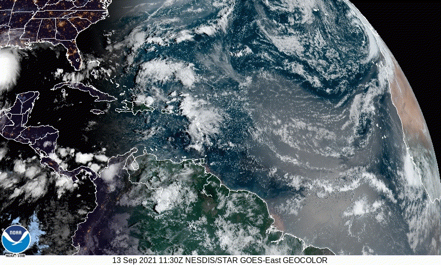
Hmm, I am seeing some organization with the system. At the very least there is an increase in convection.
0 likes
I am by no means a professional. DO NOT look at my forecasts for official information or make decisions based on what I post.
Goal: to become a registered expert over tropical and subtropical cyclones.
Goal: to become a registered expert over tropical and subtropical cyclones.
-
ouragans

- Category 1

- Posts: 464
- Age: 52
- Joined: Sun Jun 12, 2011 12:09 pm
- Location: Abymes, Guadeloupe F.W.I
- Contact:
Re: Low pressure to form near the SE Bahamas
2. An area of low pressure is forecast to form by midweek a couple of
hundred miles north of the southeastern or central Bahamas as a
tropical wave interacts with an upper-level trough. Some gradual
development of this system is possible thereafter, and a tropical
depression could form later this week while the system moves
north-northwestward or northward across the western Atlantic.
* Formation chance through 48 hours...low...10 percent.
* Formation chance through 5 days...medium...50 percent.
0 likes
Personal forecast disclaimer
This post is just a personal point of view, not an information. Please refer to official statements for life-threatening decisions.
David '79, Frederic '79, Hugo '89, Iris '95, Luis '95, Marilyn '95, Georges '98, Lenny '99, Dean '07, Irma '17, Maria '17, Fiona '22
16°13'33.3,"6N -61°36'39.5"W
This post is just a personal point of view, not an information. Please refer to official statements for life-threatening decisions.
David '79, Frederic '79, Hugo '89, Iris '95, Luis '95, Marilyn '95, Georges '98, Lenny '99, Dean '07, Irma '17, Maria '17, Fiona '22
16°13'33.3,"6N -61°36'39.5"W
-
Sciencerocks
- Category 5
- Posts: 7282
- Age: 38
- Joined: Thu Jul 06, 2017 1:51 am
-
emeraldislenc
- Category 2

- Posts: 524
- Joined: Fri Aug 24, 2012 4:49 pm
- Location: Emerald Isle NC
Re: Low pressure to form near the SE Bahamas
Any thoughts on conditions along the NC coast later thus week?
0 likes
-
Sciencerocks
- Category 5
- Posts: 7282
- Age: 38
- Joined: Thu Jul 06, 2017 1:51 am
Re: Low pressure to form near the SE Bahamas
An area of low pressure is expected to form by midweek a couple of
hundred miles north of the southeastern or central Bahamas as a
tropical wave interacts with an upper-level trough. Some gradual
development of this system is forecast thereafter, and a tropical
depression could form later this week while the system moves
north-northwestward or northward across the western Atlantic.
* Formation chance through 48 hours...low...30 percent.
* Formation chance through 5 days...medium...60 percent.
0 likes

Re: Low pressure to form near the SE Bahamas
emeraldislenc wrote:Any thoughts on conditions along the NC coast later thus week?
Most models take this system east of NC now, but could still bring high surf and rain to coastal areas by the end of the week.
0 likes
Kendall -> SLO -> PBC
Memorable Storms: Katrina (for its Florida landfall...) Wilma Matthew Irma
Memorable Storms: Katrina (for its Florida landfall...) Wilma Matthew Irma
-
cycloneye

- Admin

- Posts: 139019
- Age: 67
- Joined: Thu Oct 10, 2002 10:54 am
- Location: San Juan, Puerto Rico
Re: Low pressure to form near the SE Bahamas (Is Invest 96L)
0 likes
Visit the Caribbean-Central America Weather Thread where you can find at first post web cams,radars
and observations from Caribbean basin members Click Here
and observations from Caribbean basin members Click Here
Who is online
Users browsing this forum: ColbyP06, Dougiefresh, MetroMike, pepecool20, zzzh and 53 guests