Low Pressure / Tropical Wave WSW of Cabo Verde (is Invest 95L)

This is the general tropical discussion area. Anyone can take their shot at predicting a storms path.

Moderator: S2k Moderators

Forum rules

The posts in this forum are NOT official forecasts and should not be used as such. They are just the opinion of the poster and may or may not be backed by sound meteorological data. They are NOT endorsed by any professional institution or STORM2K. For official information, please refer to products from the National Hurricane Center and National Weather Service.

Help Support Storm2K
Message
Author
User avatar
abajan
S2K Supporter
S2K Supporter
Posts: 4175
Joined: Sun Sep 07, 2003 5:10 am
Location: Barbados

Re: Tropical Wave SW of Cabo Verde

#41 Postby abajan » Thu Jul 20, 2023 3:24 pm

LarryWx wrote:
Teban54 wrote:
LarryWx wrote:
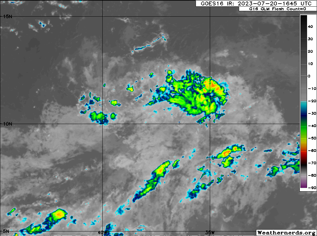
Luis and zzzh are focusing on what looks to me like a clearcut circulation based on satellite loops and ASCAT, which is near 11N, 38-39W. However, the NHC has (as shown by the TWO posted just above this) the yellow "X" near 11N, 30W (right or wrong, NHC is not focusing on the same specific area):

https://www.nhc.noaa.gov/gtwo.php?basin=atlc&fdays=2

All the models that do develop this show the circulation at 38W consolidating as well.

Meanwhile, the circ is now covered by a tiny bit of convection:
https://i.postimg.cc/zG2stLhV/90088070.gif


The models are kind of unusual with how they develop this. As Luis said and you seem to be implying, the LLC now near 38W retrogrades a little E over the next 24 hours while energy from a AEW now near 30W moves W and reaches the LLC tomorrow. They sort of collide. That must be why the yellow "X" in the TWO is at 30W. It is on the AEW rather than on the LLC. Then some models develop the LLC more.

The AEW now near 30W is mentioned in the latest TWD:

...TROPICAL WAVES...

A far eastern Atlantic tropical wave is west of the Cabo Verde Islands with its axis stretching from near 19N28W to 05N31W. It is moving westward around 10 kt. Scattered moderate convection is within 60 nm east of the wave from 07N to 10N.

The convection has been expanding. Should be interesting to see if it continues to do so (and possibly intensify) as Dmax approaches before daybreak at that location tomorrow.

Image
2 likes   

User avatar
Jr0d
S2K Supporter
S2K Supporter
Posts: 1174
Joined: Tue Aug 27, 2019 10:52 am
Location: Cayo Hueso

Re: Tropical Wave SW of Cabo Verde

#42 Postby Jr0d » Thu Jul 20, 2023 3:51 pm

Ianswfl wrote:Well, the 12 Euro ensembles has a nasty member with a cat4 heading right for Dade County after going over Haiti and bombs out over the hot waters in the Bahamas.


While highly unlikely, this is a worst case scenario of those of us in S.Florida, the Florida Keys. This system if it develops wil likely stay weak, however with the water being so hot, if a vigorous wave can stay together until it approaches the Bahamas, then find favorable conditions, it could really pop quick. Especially if the storm is small in size. Historically many of our worst storms have been relatively small but intensified as they were making landfall.
1 likes   

User avatar
Spacecoast
Category 2
Category 2
Posts: 687
Joined: Thu Aug 31, 2017 2:03 pm

Re: Tropical Wave SW of Cabo Verde

#43 Postby Spacecoast » Thu Jul 20, 2023 6:18 pm

Jr0d wrote:
Ianswfl wrote:Well, the 12 Euro ensembles has a nasty member with a cat4 heading right for Dade County after going over Haiti and bombs out over the hot waters in the Bahamas.


While highly unlikely, this is a worst case scenario of those of us in S.Florida, the Florida Keys. This system if it develops wil likely stay weak, however with the water being so hot, if a vigorous wave can stay together until it approaches the Bahamas, then find favorable conditions, it could really pop quick. Especially if the storm is small in size. Historically many of our worst storms have been relatively small but intensified as they were making landfall.


That member ends up with MH riding the East coast of Fl, doing a loop off the Georgia coast, then heads towards Jax, Fl.
There's only ~2-4% chance of this occurring....
Glass half full, I prefer to think 96% chance this doesn't happen.
0 likes   

User avatar
cycloneye
Admin
Admin
Posts: 139086
Age: 67
Joined: Thu Oct 10, 2002 10:54 am
Location: San Juan, Puerto Rico

Re: Tropical Wave SW of Cabo Verde

#44 Postby cycloneye » Thu Jul 20, 2023 6:32 pm

Up to 10%/30%.

1. Central Tropical Atlantic:
An area of low pressure has formed within the Intertropical
Convergence Zone, located several hundred miles west-southwest of
the Cabo Verde Islands. This system is also interacting with a
tropical wave located farther east, and their combination is
producing an elongated area of showers and thunderstorms over the
eastern and central tropical Atlantic. While environmental
conditions appear only somewhat favorable due to the proximity of
dry air to the north, some slow development of this system is
possible through early next week, as it begins to move westward
across the central tropical Atlantic.
* Formation chance through 48 hours...low...10 percent.
* Formation chance through 7 days...low...30 percent.


Image
2 likes   
Visit the Caribbean-Central America Weather Thread where you can find at first post web cams,radars
and observations from Caribbean basin members Click Here

User avatar
abajan
S2K Supporter
S2K Supporter
Posts: 4175
Joined: Sun Sep 07, 2003 5:10 am
Location: Barbados

Re: Tropical Wave SW of Cabo Verde

#45 Postby abajan » Thu Jul 20, 2023 6:52 pm

cycloneye wrote:Up to 10%/30%.

1. Central Tropical Atlantic:
An area of low pressure has formed within the Intertropical
Convergence Zone, located several hundred miles west-southwest of
the Cabo Verde Islands.
This system is also interacting with a
tropical wave located farther east, and their combination is
producing an elongated area of showers and thunderstorms over the
eastern and central tropical Atlantic. While environmental
conditions appear only somewhat favorable due to the proximity of
dry air to the north, some slow development of this system is
possible through early next week, as it begins to move westward
across the central tropical Atlantic.
* Formation chance through 48 hours...low...10 percent.
* Formation chance through 7 days...low...30 percent.


https://i.imgur.com/WxwbF0b.png


Indeed. I'd expected those increases in formation chances to be posted 6 hours earlier, in the previous outlook. And I see they've also shifted the area of interest from the wave to the circulation you earlier indicated. Good catch! :wink:
1 likes   

BobHarlem
Category 5
Category 5
Posts: 1665
Joined: Thu Oct 20, 2005 6:11 pm

Re: Low Pressure / Tropical Wave WSW of Cabo Verde

#46 Postby BobHarlem » Thu Jul 20, 2023 7:27 pm

Invest 95L?
AL, 95, 2023072100, , BEST, 0, 113N, 387W, 25, 1014, LO, 34, NEQ, 0, 0, 0, 0, 1016, 100, 40, 0, 0, L, 0, , 0, 0, INVEST, S, 0, , 0, 0, 0, 0, genesis-num, 014, SPAWNINVEST, al752023 to al952023,
0 likes   

tolakram
Admin
Admin
Posts: 19165
Age: 60
Joined: Sun Aug 27, 2006 8:23 pm
Location: Florence, KY (name is Mark)

Re: Low Pressure / Tropical Wave WSW of Cabo Verde

#47 Postby tolakram » Thu Jul 20, 2023 7:30 pm

BobHarlem wrote:Invest 95L?
AL, 95, 2023072100, , BEST, 0, 113N, 387W, 25, 1014, LO, 34, NEQ, 0, 0, 0, 0, 1016, 100, 40, 0, 0, L, 0, , 0, 0, INVEST, S, 0, , 0, 0, 0, 0, genesis-num, 014, SPAWNINVEST, al752023 to al952023,


You had your chance to start the topic :)

Invest 95L - https://www.storm2k.org/phpbb2/viewtopi ... 9&t=123487
1 likes   
M a r k
- - - - -
Join us in chat: Storm2K Chatroom Invite. Android and IOS apps also available.

The posts in this forum are NOT official forecasts and should not be used as such. Posts are NOT endorsed by any professional institution or STORM2K.org. For official information and forecasts, please refer to NHC and NWS products.


Return to “Talkin' Tropics”

Who is online

Users browsing this forum: Blown Away, Christiana, duilaslol, Google Adsense [Bot], KirbyDude25 and 245 guests